
Lakeshore West is one of the seven train lines of the GO Transit system in the Greater Toronto Area, Ontario, Canada. It extends from Union Station in Toronto to Hamilton, along the shore of Lake Ontario. Some train trips extend past Hamilton to St. Catharines and Niagara Falls.
The Relief Line was a proposed rapid transit line for the Toronto subway system, intended to provide capacity relief to the Yonge segment of Line 1 and Bloor–Yonge station and extend subway service coverage in the city's east end. Several plans for an east–west downtown subway line date back to the early 20th century, most of which ran along Queen Street.

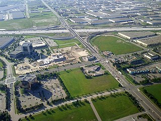
The Mississauga Transitway is a bus rapid transit (BRT) system in Mississauga, Ontario, Canada. It comprises a series of purpose-constructed bus-only roadways, as well as reserved lanes on existing city streets and portions of Highway 403, that together form a continuous 18 km (11 mi) route spanning most of the city from Winston Churchill Boulevard in the west to the junction of Highways 401 and 427 in the east on the border with Toronto. Service on the Transitway is provided by MiWay and GO Transit, with some stations providing connections to Brampton Transit and Toronto Transit Commission (TTC) bus services.

The Big Move is the regional transportation plan (RTP) published by Metrolinx for the Greater Toronto and Hamilton Area (GTHA) in Ontario, Canada. It makes specific recommendations for transit projects, resulting from seven "green papers" and two "white papers" released for public discussion. A draft RTP was released alongside draft investment strategy in September 2008. After a series of stakeholder consultations and public meetings, the final RTP was approved and published by Metrolinx on 28 November 2008.

Metrolinx is a Crown agency of the Government of Ontario that manages and integrates road and public transport in the Greater Toronto and Hamilton Area (GTHA), which comprises much of Ontario's Golden Horseshoe region. Headquartered at Union Station in Toronto, the agency was created as the Greater Toronto Transportation Authority on June 22, 2006. The agency adopted its present name as a brand name in 2007 and eventually as the legal name in 2009.

Transit City was a plan for developing public transport in Toronto, Ontario, Canada. It was first proposed and announced on 16 March 2007 by Toronto mayor David Miller and Toronto Transit Commission (TTC) chair Adam Giambrone. The plan called for the construction of seven new light rail lines along the streets of seven priority transit corridors, which would have eventually been integrated with existing rapid transit, streetcar, and bus routes. Other transit improvements outlined in the plan included upgrading and extending the Scarborough RT line, implementing new bus rapid transit lines, and improving frequency and timing of 21 key bus routes. The plan integrated public transportation objectives outlined in the City of Toronto Official Plan, the TTC Ridership Growth Strategy and Miller's 2006 election platform.
The Don Mills LRT was a proposed light rail line in Toronto, Ontario, Canada. It was part of the Transit City proposal announced March 16, 2007, to be operated by the Toronto Transit Commission (TTC). It was expected to cost approximately $675 million, with construction to begin in 2012, and an expected opening in 2016. It would have been the fifth of the seven Transit City lines to be complete after the Sheppard East, Finch West, Waterfront West, and Eglinton lines. Ridership was estimated to be 21.2 million trips in 2021.
The Waterfront West LRT (WWLRT) is a proposed streetcar line in Toronto, Ontario, Canada. The WWLRT is currently part of a City project called the Waterfront Transit Reset which also includes the East Bayfront LRT. The WWLRT was initially proposed as part of the Transit City plan to expand transit services offered by the Toronto Transit Commission that was announced March 16, 2007. The new line was to use existing parts of the Toronto streetcar system, extending from Union station to Long Branch Loop via Exhibition Place.
MoveOntario 2020 was a 2007 plan proposed by the Government of Ontario that would fund 52 rapid-transit projects throughout the Greater Toronto and Hamilton Area in Ontario, Canada. It was succeeded by The Big Move and GO Transit's Go 2020.
The Hurontario LRT is a light rail line under construction in the cities of Mississauga and Brampton, Ontario, Canada. The line will run along Hurontario Street from Mississauga's Port Credit neighbourhood north to Steeles Avenue in Brampton. The line will be built and operated as a public-private partnership by Mobilinx, a consortium of private European and Japanese companies, with provincial transit agency Metrolinx retaining ownership of the line. It will be the only street railway operating in the Greater Toronto Area outside Toronto proper.
The Hamilton LRT is a planned light rail line in Hamilton, Ontario, Canada, to operate along Main Street, King Street, and Queenston Road. It is one of five planned rapid transit lines which form Hamilton's proposed BLAST network. The 14 km (8.7 mi), 17-stop route is planned to extend from McMaster University to Eastgate Square via downtown Hamilton.

The BLAST network is a plan for a frequent rapid transit system in the city of Hamilton, Ontario, Canada. The system is planned to include five routes, with two light rail transit (LRT) lines, and three bus rapid transit (BRT) lines.

Renforth, referred to during planning as Renforth Gateway, is a bus station on the border of the cities of Mississauga and Toronto, in Ontario, Canada. Located at Eglinton Avenue and Renforth Drive, it is the eastern terminus of the Mississauga Transitway and is close to the interchange between Highway 401 and Highway 427.
Dundas Street bus rapid transit is a proposed bus rapid transit (BRT) corridor proposed by Metrolinx for the western part of the Greater Toronto and Hamilton Area in Southern Ontario, Canada. It is part of the regional transportation plan The Big Move. Metrolinx currently refers to the project as Dundas bus rapid transit without the word "Street". The City of Mississauga used the brand Dundas Connects during the development phase.
A rapid transit corridor is proposed along Steeles Avenue in Toronto, Ontario, Canada, which would be operated by the Toronto Transit Commission. It has not been determined if this corridor would be a bus rapid transit or a light rail transit line. It is identified by Metrolinx in its regional transportation plan The Big Move as a project to be completed in its 25-year plan. In February 2016, City of Toronto and TTC planners recommended implementing the Steeles BRT/LRT within a 15-year horizon. At a meeting on February 20, 2020, the Metrolinx board of directors endorsed a prioritization framework for a proposed Frequent Rapid Transit Network that included a proposed BRT from Pioneer Village station to McCowan Road. The proposed 20.8 km line along Steeles Avenue had a forecasted ridership of 11,700 in 2031. The project scored 'high' with a preliminary benefit-cost ratio of over 0.90. The TTC released their 2020-2024 5-year Service Plan and 10-year Outlook, which discussed the implementation of exclusive bus lanes, stop consolidation, all-door boarding and other transit priority measures to speed up bus service on Steeles Avenue West between Pioneer Village Station and the future Steeles Station that will be constructed as part of the Yonge North Subway Extension. Currently, the implementation timeframe is to be determined following feedback on the RapidTO Eglinton East Bus Lanes and public consultation with the surrounding community.
A bus rapid transit (BRT) corridor is proposed on Highway 427 as part of Metrolinx's regional transportation plan for the Greater Toronto and Hamilton Area, The Big Move. This BRT line would be established in two separate segments. The southern segment would begin at the Toronto Transit Commission's Kipling Station on Line 2 and proceed north along Highway 427 to Renforth station, the eastern terminus of the Mississauga Transitway. This southern segment would help augment the existing 900 Airport Rocket bus service. The northern segment would start at Toronto Pearson International Airport, and proceed non-stop to bus rapidways on Highway 7 in York Region and Queen Street in Brampton.
The Big Move is a regional transportation plan (RTP) published in 2008 and consisting of 62 rapid transit projects to be implemented across the Greater Toronto and Hamilton Area (GTHA). These rapid transit projects are intended to form a seamlessly integrated regional rapid transit network, which is the first priority action in the regional transportation plan. These projects form two long-term templates with 15 and 25 year horizons. These templates outline broad projects; specific details about technology, alignment, stations and service levels for each project are subsequently determined though a cost–benefit analysis or an environmental assessment process.

GO Expansion, previously known as GO Regional Express Rail (RER), is a project to improve GO Transit train service by adding all-day, two-way service to the inner portions of the Barrie line, Kitchener line and the Stouffville line, and by increasing frequency of train service on various lines to every 15 minutes or better on five of the corridors. This would be achieved with the electrification of at least part of the Lakeshore East line, Lakeshore West line, Barrie line, Kitchener line and Stouffville line. GO Expansion is one of the Big Move rapid transit projects.
Urban rail transit in Canada encompasses a broad range of rail mass transit systems, including commuter rail, rapid transit, light rail, and streetcar systems.
Durham–Scarborough bus rapid transit (DSBRT) is a future bus rapid transit corridor proposed by Metrolinx for the eastern part of the Greater Toronto Area in Southern Ontario, Canada. The 36-kilometre (22 mi) bus corridor will run from downtown Oshawa to Scarborough Town Centre in Toronto, mainly along Durham Region Highway 2 in Durham Region and Ellesmere Road in the Scarborough district of Toronto. Dedicated bus lanes will be used where feasible. Buses of the Toronto Transit Commission, Durham Region Transit and GO Transit would use the busway. Metrolinx has indicated that the BRT could be easily converted to LRT in the future if required.

