The South West Coast Path is England's longest waymarked long-distance footpath and a National Trail. It stretches for 630 miles (1,014 km), running from Minehead in Somerset, along the coasts of Devon and Cornwall, to Poole Harbour in Dorset. Because it rises and falls with every river mouth, it is also one of the more challenging trails. The total height climbed has been calculated to be 114,931 ft (35,031 m), almost four times the height of Mount Everest. It has been voted 'Britain's Best Walking route' twice in a row by readers of The Ramblers' Walk magazine, and regularly features in lists of the world's best walks.

Exmoor is loosely defined as an area of hilly open moorland in west Somerset and north Devon in South West England. It is named after the River Exe, the source of which is situated in the centre of the area, two miles north-west of Simonsbath. Exmoor is more precisely defined as the area of the former ancient royal hunting forest, also called Exmoor, which was officially surveyed 1815–1818 as 18,810 acres (7,610 ha) in extent. The moor has given its name to a National Park, which includes the Brendon Hills, the East Lyn Valley, the Vale of Porlock and 55 km (34 mi) of the Bristol Channel coast. The total area of the Exmoor National Park is 692.8 km2 (267.5 sq mi), of which 71% is in Somerset and 29% in Devon.

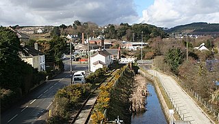
Lynton is a town on the Exmoor coast in the North Devon district in the county of Devon, England, approximately 17 miles (27 km) north-east of Barnstaple and 18 miles (29 km) west of Minehead, and close to the confluence of the West Lyn and East Lyn rivers.

North Devon is a local government district in Devon, England. North Devon Council is based in Barnstaple. Other towns and villages in the North Devon District include Braunton, Fremington, Ilfracombe, Instow, South Molton, Lynton and Lynmouth. The district was formed on 1 April 1974 as a merger of the Barnstaple municipal borough, the Ilfracombe and Lynton urban districts, and the Barnstaple and South Molton rural districts.

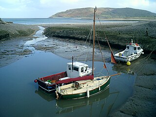
Lynmouth is a village in Devon, England, on the northern edge of Exmoor. The village straddles the confluence of the West Lyn and East Lyn rivers, in a gorge 700 feet (210 m) below Lynton, which was the only place to expand to once Lynmouth became as built-up as possible. The villages are connected by the Lynton and Lynmouth Cliff Railway, which works two cable-connected cars by gravity, using water tanks.
Porlock is a coastal village in Somerset, England, 5 miles (8 km) west of Minehead. At the 2011 census, the village had a population of 1,440.
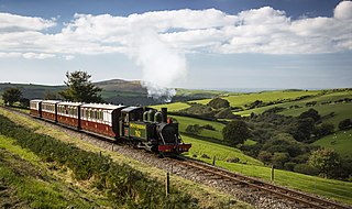
The Lynton and Barnstaple Railway (L&B) opened as an independent railway in May 1898. It was a single track, 1 ft 11+1⁄2 in narrow gauge railway and was slightly over 19 miles (31 km) long running through the rugged and picturesque area bordering Exmoor in North Devon, England. Although opened after the Light Railways Act 1896 came into force, it was authorised and constructed prior to that act. Therefore, as with all other railways, it was authorised under its own Act of Parliament and built to higher standards than similar railways of the time. In the United Kingdom it was notable as being the only narrow gauge line required to use main-line standard signalling. For a short period the line earned a modest return for shareholders, but for most of its life the L&B made a loss. In 1923, the L&B was taken over by the Southern Railway, and eventually closed in September 1935.
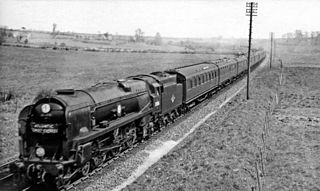
The Atlantic Coast Express (ACE) is an express passenger train in England that has operated at various times between London and seaside resorts in the South West England. It is currently operated as a summer only service by Great Western Railway between London Paddington and Newquay.

The Tarka Trail is a series of footpaths and cyclepaths around north Devon, England that follow the route taken by the fictional Tarka the Otter in the book of that name. It covers a total of 180 miles (290 km) in a figure-of-eight route, centred on Barnstaple.

Woody Bay is a bay on the North Devon coast of England, 3 miles (4.8 km) west of Lynton and 8 miles (13 km) east of Combe Martin with a stony beach. It lies in the civil parish of Martinhoe at the edge of the Exmoor National Park and is a waypoint on the South West Coast Path. There were once plans to develop the area to become a holiday resort.

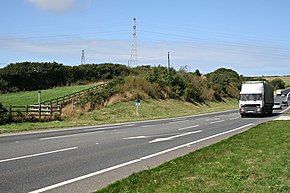
Porlock Hill is a road west of Porlock, Somerset. It is part of the A39, connecting Porlock to Lynmouth and Barnstaple in Devon and is the steepest A-road in the United Kingdom, approaching 1 in 4 (25%) in places. A parallel toll road is available which travels the same route at an easier gradient.
Caffyns Halt was a halt on the Lynton and Barnstaple Railway, a narrow gauge line that ran through Exmoor, England, from Barnstaple to Lynton and Lynmouth in North Devon. The station primarily served Caffyns Golf Links, as well as the rural area near the hamlet of Dean. It opened in 1907, and closed on 29 September 1935. From 1923 until closure the line was operated by the Southern Railway.

The Lynton and Lynmouth Cliff Railway is a water-powered funicular railway joining the twin towns of Lynton and Lynmouth on the rugged coast of North Devon in southwest England.
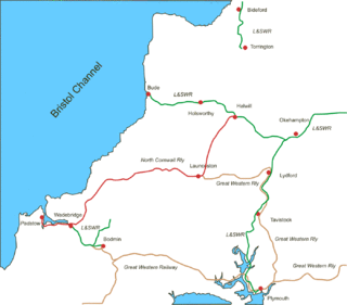
The North Cornwall Railway was a railway line running from Halwill in Devon to Padstow in Cornwall via Launceston, Camelford and Wadebridge, a distance of 49 miles 67 chains. Opened in the last decade of the nineteenth century, it was part of a drive by the London and South Western Railway (LSWR) to develop holiday traffic to Cornwall. The LSWR had opened a line connecting Exeter with Holsworthy in 1879, and by encouraging the North Cornwall Railway it planned to create railway access to previously inaccessible parts of the northern coastal area.
The evolution of transport in Cornwall has been shaped by the county's strong maritime, mining and industrial traditions and much of the transport infrastructure reflects this heritage.

Quantock Motor Services is a privately owned bus operator in Bishops Lydeard, Somerset, England. The company operates a substantial heritage fleet for private hire and on route 300.
Lynmouth Lifeboat Station was the base for Royal National Lifeboat Institution (RNLI) search and rescue operations at Lynmouth, Devon in England from 1869 until 1944. Its best known action was in 1899 when the lifeboat was taken 15 miles (24 km) across Exmoor before being launched to assist a ship in trouble.

The Exmoor Group is a late Devonian to early Carboniferous lithostratigraphic group in southwest England whose outcrop extends from Croyde in north Devon east across Exmoor to Minehead in west Somerset. The group comprises the following formations the:

Lynton and Lynmouth, also known as Little Switzerland, is the scenic landscape in and around the villages of Lynton and Lynmouth in Devon, which resembles the landscapes of Switzerland. It includes the surrounding coast and countryside: Valley of Rocks, Watersmeet and Heddon Valley. The resemblance was popularised by the Romantic Movement poets Wordsworth, Coleridge, Shelley and Southey:
From the Summerhouse Hill between the two is a prospect most magnificent - on either hand, combes and river; before, the beautiful little village, which, I am assured by one who is familiar with Switzerland, resembles a Swiss village".
The geology of Exmoor National Park in south-west England contributes significantly to the character of Exmoor, a landscape which was designated as a national park in 1954. The bedrock of the area consists almost wholly of a suite of sedimentary rocks deposited during the Devonian, a period named for the English county of Devon in which the western half of the park sits. The eastern part lies within Somerset and it is within this part of the park that limited outcrops of Triassic and Jurassic age rocks are to be found.