A465 road

Last updated

UK road A465.svg
A465
The Heads of the Valleys Road A465 road (2012).jpg
Route information
Maintained by English local authorities and South Wales Trunk Road Agency
Length66 mi (106 km)
Major junctions
West end Llandarcy
51°38′57″N3°50′55″W / 51.6492°N 3.8486°W / 51.6492; -3.8486 (A465 road (western end))
Major intersectionsUK-Motorway-M4.svg M4 Junction 43
A48
UK road A474.svg A474
UK road A4230.svg A4230
UK road A4109.svg A4109
UK road A4061.svg A4061
UK road A4059.svg A4059
UK road A470.svg A470
UK road A4054.svg A4054
UK road A4060.svg A4060
UK road A469.svg A469
UK road A4048.svg A4048
UK road A4046.svg A4046
UK road A4047.svg A4047
UK road A467.svg A467
UK road A4077.svg A4077
UK road A4143.svg A4143
UK road A4042.svg A4042
A40
A49
East end Bromyard, Herefordshire
52°11′13″N2°30′50″W / 52.1870°N 2.5139°W / 52.1870; -2.5139 (A465 road (eastern end))
Location
Country United Kingdom
Primary
destinations
Neath
Merthyr Tydfil
Abergavenny
Hereford
Road network
UK road A464.svg A464 UK road A466.svg A466

The A465 is a trunk road that runs from Bromyard in Herefordshire, England to Llandarcy near Swansea in south Wales. The western half in Wales is known officially as the Neath to Abergavenny Trunk Road, [1] but the section from Abergavenny to the Vale of Neath is more commonly referred to as the Heads of the Valleys Road because it links the northern heads of the South Wales Valleys. Approximately following the southern boundary of the Brecon Beacons National Park, the Ordnance Survey Pathfinder guide describes it as the unofficial border between rural and industrial South Wales. [2] The A465 provides an alternative route between England and the counties in South West Wales and to the ferries to Ireland. [3]

Contents

Route

The A465 runs south-west from Bromyard towards the River Lugg, from where it runs concurrently with the A4103 for a short distance before entering Hereford. After a short distance on the A49, it crosses the River Wye, the River Monnow and the border into Wales. The A465 meets the A40 trunk road in Abergavenny and continues west through the 'Heads of the Valleys' region past Brynmawr, Ebbw Vale, Tredegar, Rhymney, Merthyr Tydfil, Hirwaun, Glynneath and Aberdulais.

Dowlais Top Route of former Abergavenny - Merthyr railway being incorporated in new A465 Heads of Valley road 1736770 6a95992b.jpg
The A465 runs over the former Merthyr, Tredegar and Abergavenny Railway line (1965)
Highest point on the Heads of the Valleys Road - geograph.org.uk - 2952406.jpg
Highest point of the A465 road

Even before the construction of the Heads of the Valleys road began in the 1960s, there were concerns and complaints regarding the capacity and safety of a single carriageway, three-lane design. The Abergavenny Neath trunk road opened in 1964. [4]

Until 1996, the A465 ran for most of its length between Glynneath and Aberdulais along a narrow single carriageway road, now redesignated as the B4242. The high collision rate on this stretch was the main factor in leading to the construction of the dual carriageway between these points. The section of the A465 from Hirwaun to Llandarcy is all dual carriageway. [5] [6]

The highest point (signposted) of 1,350 feet (410 m) is on the Ebbw Vale section which is now dual carriageway and slip roads between Dowlais Top and Tredegar via Rhymney. At Dowlais Top there are link roads such as the A4060, which runs down to the south end of Merthyr Tydfil and links with the A470, and the A4054 which goes through Merthyr Vale and Aberfan. Another link is the A4102 which leads into Dowlais and Merthyr Tydfil town centre. The A465 passes Prince Charles Hospital in Merthyr Tydfil and then continues to Cefn-coed-y-cymmer and the A470 link. It then continues down the floor of the Vale of Neath, bypassing Resolven, Neath and Skewen, before terminating at junction 43 of the M4 at Llandarcy.

Major upgrade

In 1990, a regional traffic study identified the need for improvements to the A465. In 1994, alternatives were presented for public consultation for the improvement of the 25-mile length between Abergavenny and Hirwaun, connecting the existing A465 dual carriageway link from Swansea to the A40, which is an important part of the route to the M50. In July 1995 the then Secretary of State for Wales announced the preferred route. This mainly consisted of widening the existing road to provide a dual carriageway standard with grade-separated junctions (and extra climbing lanes on certain hills) between Abergavenny and Hirwaun. The design was developed and a draft line order was published in 1997. This was tested at public local inquiry in 1998 after which the Secretary of State for Wales announced the decision to proceed with the scheme in 1999.

Much of the land on the route is undulating, but despite this, the preferred route alignment is considered to be of high standard and as such allows most of the route to have the national speed limit. [7]

Initially, the upgrade was split into seven sections. Later, sections 6 and 7 were combined into a single scheme for the purposes of construction.

A465 upgrade sections are
SectionFrom / ToCommencement dateCompletion dateStatusFinal Cost
1 Abergavenny to Gilwern February 2005May 2008Complete£57m [8]
2 Gilwern to Brynmawr December 2014 [9] December 2021 [10] Complete£336.2m [8]
3 Brynmawr to Tredegar January 2013September 2015Complete£163.3m [8]
4 Tredegar to Dowlais Top March 2002November 2004Complete£57.8m [8]
5 & 6 Dowlais Top to Hirwaun Early 2021 [11] Due by mid-2025 [11] Under construction£590m [12]
(estimated)

The A465 between Llandarcy and Hirwaun was initially constructed to dual carriageway standard, and as such will not see a major upgrade. Construction work began on section 4 (Tredegar to Dowlais Top) in early spring 2002, and was completed by November 2004.

Construction of section 1 (Abergavenny to Gilwern) began in February 2005. This was primarily an on-line upgrade of the existing single-carriageway road, and was completed on 22 May 2008.

The contract for Section 3 (Brynmawr to Tredegar) was awarded to Carillion in March 2010. In August 2012, it was announced that approval for the scheme to commence had been given and that construction would commence by the end of 2012. [13]

Planning for Section 2 (Gilwern to Brynmawr) started in June 2011, with construction beginning in January 2015. [14] The project saw several delays and cost overruns, and was completed in December 2021. [15]

On 10 November 2020, the Welsh Government announced that the contract for Section 5 & 6 (Dowlais Top to Hirwaun) had been awarded to Future Valleys Construction, a consortium which 'comprises large international construction companies alongside established financial investors'. [16] Site clearance works began shortly thereafter, and major construction work commenced in May 2021. Completion of the scheme is programmed for mid-2025. [17]

Taf Fawr on the A465.jpg
The junction of the A470 and A465 during construction in 2023

See also

Related Research Articles

<span class="mw-page-title-main">A40 road</span> Road in Great Britain, connecting London to Wales

The A40 is a trunk road which runs between London and Goodwick (Fishguard), Wales, and officially called The London to Fishguard Trunk Road (A40) in all legal documents and Acts. Much of its length within England has been superseded by motorways, such as the M40, and has lost its trunk road status, though it retains it west of Gloucester, including its length within Wales. It is approximately 260 miles (420 km) long. The eastern section from Denham, Buckinghamshire to Wheatley, Oxfordshire is better served by the M40 and its former function of linking London with Cheltenham and Gloucester has been taken by the M4, A419 and A417 via Swindon.

<span class="mw-page-title-main">A470 road</span> Major long-distance road in Wales

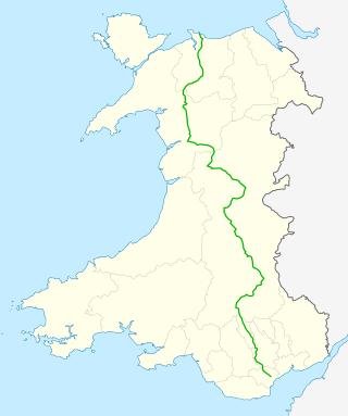
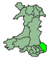
The A470 is a trunk road in Wales. It is the country's longest road at 186 miles (299 km) and links the capital Cardiff on the south coast to Llandudno on the north coast. While previously one had to navigate the narrow roads of Llanidloes and Dolgellau, both these market towns are now bypassed due to extensive road modernisation. The 26 miles (42 km) from Cardiff Bay to Merthyr Tydfil are mainly dual carriageway, but most of the route from north of Merthyr to Llandudno is single carriageway.

The Brecon and Merthyr Tydfil Junction Railway (B&MR) was a railway company in Wales. It was originally intended to link the towns in its name. Finding its access to Merthyr difficult at first, it acquired the Rumney Railway, an old plateway, and this gave it access to Newport docks. This changed its emphasis from rural line to mineral artery.

<span class="mw-page-title-main">South Wales Valleys</span> Group of industrialised peri-urban valleys in South Wales

The South Wales Valleys are a group of industrialised peri-urban valleys in South Wales. Most of the valleys run north–south, roughly parallel to each other. Commonly referred to as "The Valleys", they stretch from Carmarthenshire in the west to Monmouthshire in the east; to the edge of the pastoral country of the Vale of Glamorgan and the coastal plain near the cities of Swansea, Cardiff, and Newport.

<span class="mw-page-title-main">Merthyr line</span> Commuter railway line in South Wales

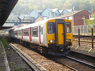
The Merthyr line is a commuter railway line in South Wales from central Cardiff to Merthyr Tydfil and Aberdare. The line is part of the Cardiff urban rail network, known as the Valley Lines.

<span class="mw-page-title-main">Transport in Wales</span> Overview of the transportation system in Wales

Transport in Wales is heavily influenced by the country's geography. Wales is predominantly hilly or mountainous, and the main settlements lie on the coasts of north and south Wales, while mid Wales and west Wales are lightly populated. The main transport corridors are east–west routes, many continuing eastwards into England.

<span class="mw-page-title-main">Rhigos</span> Human settlement in Wales

Rhigos is a small village on the saddle of higher ground between the Vale of Neath and the Cynon Valley. It was part of the old Neath Rural district Council under Glamorgan until 1974. The village then came under the jurisdiction of The Cynon Valley Borough which subsequently became Rhondda Cynon Taf, South Wales in 1996. It lies just off the old Aberdare road that was the main link between Aberdare and Glynneath, before the A465 road was extended in the 1960s. The hamlets of Cefn Rhigos and Cwm-Hwnt lie to the west of the main village.

<span class="mw-page-title-main">Blaengwrach</span> Human settlement in Wales

Blaengwrach is a community near Glynneath and Resolven in the county borough of Neath Port Talbot, Wales. It is also the name of an electoral ward of Neath Port Talbot county borough, which is a larger area than the Community. The principal settlement is Cwmgwrach, a village on the south side of the Neath valley, of which the eastern end is called Blaengwrach, which sometimes causes confusion.

The Vale of Neath Railway (VoNR) was a broad gauge railway company, that built a line from Merthyr Tydfil and Aberdare to Neath, in Wales, mostly to transport the products of the Merthyr iron industries to ports on Swansea Bay.

Clydach is a village in Monmouthshire, Wales. Its nearest neighbours are the village of Gilwern and town of Abergavenny.

<span class="mw-page-title-main">Gilwern</span> Village in Monmouthshire, Wales

Gilwern is a village within the Brecon Beacons National Park in Monmouthshire, Wales. Historically in Brecknockshire, it extends to either side of the River Clydach on the south side of the Usk valley. Its position beside the Monmouthshire and Brecon Canal led to it being an important industrial centre at one time.

The Merthyr, Tredegar and Abergavenny Railway, also known as the Heads of the Valleys line, was a railway line which operated between 1860 and 1958 between the Monmouthshire town of Abergavenny and the Glamorgan town of Merthyr Tydfil in South East Wales.

<span class="mw-page-title-main">A4060 road</span> Road in Wales

The A4060, also known as the East of Abercynon to East of Dowlais Trunk Road, is a trunk road in Wales.

The Clydach Gorge is a steep-sided valley in south-east Wales down which the River Clydach flows to the River Usk. It runs for 5.6 kilometres (3.5 mi) from the vicinity of Brynmawr in Blaenau Gwent eastwards and northeastwards to Gilwern in Monmouthshire. The Gorge was one of the first locations in the region to be industrialised though it still retains its natural environment. It has long been an important transport corridor between Abergavenny and the lowlands of Monmouthshire and the northeastern quarter of the South Wales Coalfield. It is now exploited by the A465 Heads of the Valleys trunk road which runs between Abergavenny and Swansea and which serves the Heads of the Valleys sub-region.

The Newport, Abergavenny and Hereford Railway was a railway company formed to connect the places in its name. When it sought Parliamentary authorisation, it was denied the southern section, and obliged to use the Monmouthshire Railway between Pontypool and Newport.

The Vale of Neath, one of the South Wales Valleys, encompasses the upper reaches of the River Neath in southwest Wales. In addition to the River Neath, it is traversed by the Neath Canal and the A465 dual carriageway.

<span class="mw-page-title-main">Nantybwch railway station</span> Former railway station in Monmouthshire, Wales

Nantybwch railway station was a station on the London and North Western Railway's Heads of the Valleys line serving the village of Nantybwch in the Welsh county of Monmouthshire.

Trevil Halt railway station was a station on the London and North Western Railway's Heads of the Valleys line serving the village of Trefil in the Welsh county of Monmouthshire.

<span class="mw-page-title-main">Gilwern Halt railway station</span> Former railway station in Wales

Gilwern Halt railway station was a station on the London and North Western Railway's Heads of the Valleys line near the village of Gilwern in the Welsh county of Brecknockshire.

<span class="mw-page-title-main">Dowlais Top (LNWR) railway station</span> Disused railway station in Dowlais, Merthyr Tydfil

Dowlais Top (LNWR) railway station served the village of Dowlais, Merthyr Tydfil, Wales from 1862 to 1962 on the Merthyr, Tredegar and Abergavenny Railway. The station consisted of two platforms with services to both Brecon and Newport. The station closed in 1962 along with the line and has since been demolished. The site now occupied by an industrial estate and trackbed forms part of a one way lane for the Heads of the Valley Road. The old station building has survived as an office.

References

  1. "A465 HEADS OF THE VALLEYS DUALLING SECTION 3: BRYNMAWR TO TREDEGAR" (PDF). Carillion plc. Archived from the original (PDF) on 2 April 2015. Retrieved 10 March 2015.
  2. OS Pathfinder Guide, Brecon Beacons and Glamorgan. Ordnance Survey 1994.
  3. Welsh Government – A465 (Heads of the Valleys Road) – Dualling Scheme Archived 16 May 2013 at the Wayback Machine
  4. "Heads of the Valleys Road". Parliamentary Debates (Hansard) . 17 February 1960.
  5. "A465". Parliamentary Debates (Hansard) . 8 June 1992.
  6. "Cymdeithas Hanes Resolfen History Society: Where is Resolfen?".
  7. "New higher speed limits for lorries in England and Wales". THE HIGHWAY CODE.
  8. 1 2 3 4 "Request for Information - ATISN 18667" (PDF). Welsh Government. 26 July 2023. Retrieved 8 March 2024.
  9. "Green light for next stage of widening project | A465 Section 2". Archived from the original on 21 February 2015. Retrieved 21 February 2015.
  10. "Written Statement: A465 Dualling Section 2 (Gilwern to Brynmawr) Project Update". Welsh Government . Retrieved 1 March 2021.
  11. 1 2 "A465 section 5 and 6 Dowlais Top to Hirwaun". Welsh Government . Retrieved 21 December 2019.
  12. "A465 section 5 and 6 Dowlais Top to Hirwaun". Welsh Government. 7 December 2023. Retrieved 8 March 2024.
  13. "A465 Road Dualling Scheme Brynmawr to Tredegar". Archived from the original on 16 June 2016. Retrieved 6 June 2020.
  14. "A465 Section 2 Project Website". Archived from the original on 9 January 2013. Retrieved 7 October 2012.
  15. "Heads of the Valleys road section opens three years late". BBC. 30 December 2021.
  16. "A465: Contract awarded for A465 improvements". 10 November 2021 via gov.wales.
  17. "A465: Section 5 & 6 Dowlais Top to Hirwaun Overview". 8 July 2021 via gov.wales.

51°50′39″N3°00′00″W / 51.8442°N 2.9999°W / 51.8442; -2.9999 (A465 road)