
A natural disaster is the highly harmful impact on a society or community following a natural hazard event. Some examples of natural hazard events include: flooding, drought, earthquake, tropical cyclone, lightning, tsunami, volcanic activity, wildfire. A natural disaster can cause loss of life or damage property, and typically leaves economic damage in its wake. The severity of the damage depends on the affected population's resilience and on the infrastructure available. Scholars have been saying that the term natural disaster is unsuitable and should be abandoned. Instead, the simpler term disaster could be used, while also specifying the category of hazard. A disaster is a result of a natural or human-made hazard impacting a vulnerable community. It is the combination of the hazard along with exposure of a vulnerable society that results in a disaster.
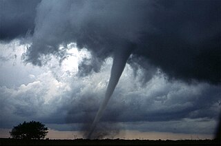
Extreme weather includes unexpected, unusual, severe, or unseasonal weather; weather at the extremes of the historical distribution—the range that has been seen in the past. Extreme events are based on a location's recorded weather history. They are defined as lying in the most unusual ten percent. The main types of extreme weather include heat waves, cold waves and heavy precipitation or storm events, such as tropical cyclones. The effects of extreme weather events are economic costs, loss of human lives, droughts, floods, landslides. Severe weather is a particular type of extreme weather which poses risks to life and property.

Tropical Storm Allison was a tropical storm that devastated southeast Texas in June of the 2001 Atlantic hurricane season. An arguable example of the "brown ocean effect", Allison lasted unusually long for a June storm, remaining tropical or subtropical for 16 days, most of which was when the storm was over land dumping torrential rainfall. The storm developed from a tropical wave in the northern Gulf of Mexico on June 4, 2001, and struck the upper Texas coast shortly thereafter. It drifted northward through the state, turned back to the south, and re-entered the Gulf of Mexico. The storm continued to the east-northeast, made landfall on Louisiana, then moved across the southeast United States and Mid-Atlantic. Allison was the first storm since Tropical Storm Frances in 1998 to strike the northern Texas coastline.

Pineapple Express is a specific recurring atmospheric river both in the waters immediately northeast of the Hawaiian Islands and extending northeast to any location along the Pacific coast of North America. It is a non-technical term and a meteorological phenomenon. It is characterized by a strong and persistent large-scale flow of warm moist air, and the associated heavy precipitation. A Pineapple Express is an example of an atmospheric river, which is a more general term for such relatively narrow corridors of enhanced water vapor transport at mid-latitudes around the world.

Hurricane Ivan was a large, long-lived, Cape Verde hurricane that caused widespread damage in the Caribbean and United States. The cyclone was the ninth named storm, the sixth hurricane and the fourth major hurricane of the active 2004 Atlantic hurricane season.
The National Flood Insurance Program (NFIP) is a program created by the Congress of the United States in 1968 through the National Flood Insurance Act of 1968. The NFIP has two purposes: to share the risk of flood losses through flood insurance and to reduce flood damages by restricting floodplain development. The program enables property owners in participating communities to purchase insurance protection, administered by the government, against losses from flooding, and requires flood insurance for all loans or lines of credit that are secured by existing buildings, manufactured homes, or buildings under construction, that are located in the Special Flood Hazard Area in a community that participates in the NFIP. U.S. Congress limits the availability of National Flood Insurance to communities that adopt adequate land use and control measures with effective enforcement provisions to reduce flood damages by restricting development in areas exposed to flooding.

Typhoon Vera, also known as the Isewan Typhoon, was an exceptionally intense tropical cyclone that struck Japan in September 1959, becoming the strongest and deadliest typhoon on record to make landfall on the country as a Category 5 equivalent storm. The storm's intensity resulted in catastrophic damage of unparalleled severity and extent, and was a major setback to the Japanese economy, which was still recovering from World War II. In the aftermath of Vera, Japan's disaster management and relief systems were significantly reformed, and the typhoon's effects would set a benchmark for future storms striking the country.
The Climate Change Science Program (CCSP) was the program responsible for coordinating and integrating research on global warming by U.S. government agencies from February 2002 to June 2009. Toward the end of that period, CCSP issued 21 separate climate assessment reports that addressed climate observations, changes in the atmosphere, expected climate change, impacts and adaptation, and risk management issues. Shortly after President Obama took office, the program's name was changed to U.S. Global Change Research Program (USGCRP) which was also the program's name before 2002. Nevertheless, the Obama Administration generally embraced the CCSP products as sound science providing a basis for climate policy. Because those reports were mostly issued after the Fourth Assessment Report of the Intergovernmental Panel on Climate Change (IPCC), and in some cases focused specifically on the United States, they were generally viewed within the United States as having an importance and scientific credibility comparable to the IPCC assessments for the first few years of the Obama Administration.

All types of floods can occur in California, though 90 percent of them are caused by river flooding in lowland areas. Such flooding generally occurs as a result of excessive rainfall, excessive snowmelt, excessive runoff, levee failure, poor planning or built infrastructure, or a combination of these factors. Below is a list of flood events that were of significant impact to California.
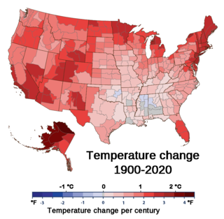
Climate change has led to the United States warming by 2.6 °F since 1970. The climate of the United States is shifting in ways that are widespread and varied between regions. From 2010 to 2019, the United States experienced its hottest decade on record. Extreme weather events, invasive species, floods and droughts are increasing. Climate change's impacts on tropical cyclones and sea level rise also affects regions of the country.

Flood control methods are used to reduce or prevent the detrimental effects of flood waters. Flooding can be caused by a mix of both natural processes, such as extreme weather upstream, and human changes to waterbodies and runoff. Flood control methods can be either of the structural type and of the non-structural type. Structural methods hold back floodwaters physically, while non-structural methods do not. Building hard infrastructure to prevent flooding, such as flood walls, is effective at managing flooding. However, best practice within landscape engineering is more and more to rely on soft infrastructure and natural systems, such as marshes and flood plains, for handling the increase in water.

The Great Flood of 1862 was the largest flood in the recorded history of California, Oregon, and Nevada, inundating the western United States and portions of British Columbia and Mexico. It was preceded by weeks of continuous rains and snows that began in Oregon in November 1861 and continued into January 1862. This was followed by a record amount of rain from January 9–12, and contributed to a flood that extended from the Columbia River southward in western Oregon, and through California to San Diego, and extended as far inland as (now) Idaho in the Washington Territory, (now) Nevada and Utah in the Utah Territory, and (now) Arizona in the western New Mexico Territory. The event dumped an equivalent of 10 feet (3.0 m) of water in California, in the form of rain and snow, over a period of 43 days. Immense snowfalls in the mountains of far western North America caused more flooding in Idaho, Arizona, New Mexico, as well as in Baja California and Sonora, Mexico the following spring and summer, as the snow melted.

An atmospheric river (AR) is a narrow corridor or filament of concentrated moisture in the atmosphere. Other names for this phenomenon are tropical plume, tropical connection, moisture plume, water vapor surge, and cloud band.
The California flood of 1605 was a massive flood that submerged large portions of present-day California. The megaflood was a result of sustained major rain storms across the region, enhanced by an unusually powerful atmospheric river. The flooding affected the indigenous peoples of California, in pre-industrial advancement populations.

Hurricane Andrew was a compact, but very powerful and destructive Category 5 Atlantic hurricane that struck the Bahamas, Florida, and Louisiana in August 1992. It is the most destructive hurricane to ever hit Florida in terms of structures damaged or destroyed, and remained the costliest in financial terms until Hurricane Irma surpassed it 25 years later. Andrew was also the strongest landfalling hurricane in the United States in decades and the costliest hurricane to strike anywhere in the country, until it was surpassed by Katrina in 2005. In addition, Andrew is one of only four tropical cyclones to make landfall in the continental United States as a Category 5, alongside the 1935 Labor Day hurricane, 1969's Camille, and 2018's Michael. While the storm also caused major damage in the Bahamas and Louisiana, the greatest impact was felt in South Florida, where the storm made landfall as a Category 5 hurricane, with 1-minute sustained wind speeds as high as 165 mph (266 km/h) and a gust as high as 174 mph (280 km/h). Passing directly through the cities of Cutler Bay and Homestead in Dade County, the hurricane stripped many homes of all but their concrete foundations and caused catastrophic damage. In total, Andrew destroyed more than 63,500 houses, damaged more than 124,000 others, caused $27.3 billion in damage, and left 65 people dead.
Flooding in 2017 affected parts of California in the first half of the year. Northern California saw its wettest winter in almost a century, breaking the record set in 1982–83. The same storm systems also flooded parts of western Nevada and southern Oregon. The damage was estimated at $1.55 billion ($1,926,663,046 today), including damage to California roads and highways estimated at more than $1.05 billion.

Climate change is having serious impacts in the Philippines such as increased frequency and severity of natural disasters, sea level rise, extreme rainfall, resource shortages, and environmental degradation. All of these impacts together have greatly affected the Philippines' agriculture, water, infrastructure, human health, and coastal ecosystems and they are projected to continue having devastating damages to the economy and society of the Philippines.

Climate change is affecting Austrian temperatures, weather, ecosystems and biodiversity. Since 1950 temperatures have risen by 1.8 °C, and in the past 150 years glaciers have melted, losing a significant amount of their volume. Changed precipitation patterns, increased temperatures, reduced snowfall, melting glaciers and more frequent extreme weather phenomenon, such as droughts, are expected effects from climate change. Ecosystems and biodiversity in Austria are facing changes due to increasing temperatures and the spread of thermophile species, heat and drought stress on animals and plants, an increase in alien and invasive species and an increase in pathogenic organisms and the spread of disease.

