Abbotts Lagoon

Last updated

Abbotts Lagoon
Abbotts Lagoon, October 2012.jpg
Relief map of California.png
Red pog.svg
Abbotts Lagoon
Usa edcp relief location map.png
Red pog.svg
Abbotts Lagoon
Location Marin County, California
Coordinates 38°7′3″N122°57′12″W / 38.11750°N 122.95333°W / 38.11750; -122.95333 Coordinates: 38°7′3″N122°57′12″W / 38.11750°N 122.95333°W / 38.11750; -122.95333 [1]
Type lagoon
Primary outflows Pacific Ocean
Basin  countriesUnited States
Surface elevationsea level

Abbotts Lagoon is a two-stage lagoon on the northwestern coast of the Point Reyes National Seashore, southwest of Tomales Point, in California, United States. The upper lagoon is a freshwater impoundment that overflows into a lower brackish level with occasional winter tidal exchange. [2] The eastern shore of the lagoon is covered with old growth northern coastal scrub including coyote bush, yellow bush lupine, sword fern and California blackberry. [3]

Contents

Geology

Abbotts Lagoon is usually separated from the Pacific Ocean by dune sand to the west. The eastern side of the lagoon is bordered by Miocene marine sediments to the north and Pliocene marine sediments to the south from sedimentary rock formations on the western side of the San Andreas Fault. [4] Santa Margarita Sandstone atop the Monterey Formation forms a ridge along the southern side of the valley containing the upper lagoon, and is exposed along the eastern shoreline of the lower lagoon. [5]

History

Coast Miwok lived in the area before 19th-century European colonization. The lagoon land was used for cattle and dairy ranching by the 1870s. [5] Abbotts Lagoon was variously identified as Abbott's Lagoon Bombing Target, Abbott's Lagoon Target Area, Abbott's Lagoon Bombing Range, and Bombing Range Number Two while used as a dive bomber practice area by pilots from Alameda Naval Air Station and Santa Rosa outlying field from 1941 to 1952. [6] The lagoon was designated part of Point Reyes National Seashore in 1962. [5]

Recreation

Walking trails provide access to observe the birds and wildflowers of the locally unique habitats surrounding Abbotts Lagoon. [7] Brush rabbits, black-tailed jackrabbits, pocket gophers, muskrats, river otter and black-tailed deer may be seen around the lagoon. Coyote, bobcat, gray fox, long-tailed weasel, striped skunk, raccoon, badger, and cougar are rarely seen. [8]

Birding

Great blue heron at Abbotts Lagoon Abbott's Lagoon (37375p).jpg
Great blue heron at Abbotts Lagoon

Bird species observed at Abbotts Lagoon include:

Flora

Abbotts Lagoon is the location of the single remaining natural population of the endangered plant species Sonoma spineflower (Chorizanthe valida). [21]

See also

Related Research Articles

Birds of North American boreal forests

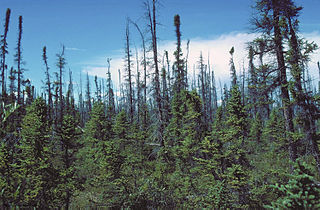
The boreal forest or taiga of the North American continent stretches through a majority of Canada and most of central Alaska, extending spottily into the beginning of the Rocky Mountain range in Northern Montana and into New England and the Adirondack Mountains of New York. This habitat extends as far north as the tree line and discontinues in mixed deciduous-coniferous forests to the south. The "taiga", as it is called there, of Eurasia occupies a similar range on those continents. Throughout the Northern Hemisphere, the boreal forest covers 2.3 million square miles, a larger area than the remaining Brazilian Amazon rain forest. Although it is largely forest, the boreal forests include a network of lakes, river valleys, wetlands, peat lands and semi-open tundra.

<span class="mw-page-title-main">Fauna of Toronto</span>

The fauna of Toronto include a variety of different species situated within the city limits. Toronto contains a mosaic of ecosystems that includes forests, rivers and streams, and wetlands, which allows it to support a large variety of fauna. Approximately 90 per cent of animals that inhabit the city reside within the Toronto ravine system. A number of other animals have also adapted to the Toronto's urban environment, parks, and the creeks and rivers that run throughout the city.

<span class="mw-page-title-main">Shollenberger Park</span>

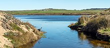
Shollenberger Park is a 165-acre (0.67 km2) wetland park located in Petaluma, California. Together with the 80-acre (320,000 m2) Alman Marsh, and 260-acre (1.1 km2) Ellis Creek which opened to the public in July 2009, a total of 505 acres (2.04 km2) are accessible to the public. The entirety is referred to as the "Petaluma Wetlands".

References

  1. "Abbotts Lagoon". Geographic Names Information System . United States Geological Survey, United States Department of the Interior.
  2. "Abbotts Lagoon". Great Outdoor Recreation Pages. Archived from the original on 9 September 2010. Retrieved 23 August 2011.
  3. Stallcup, Rich & Pitkin, Melissa Discovering Birds at Point Reyes (2007) Point Reyes National Seashore Association ISBN   0-9607890-6-5 pp. 35–37
  4. Koenig, James B. Geologic Map of California:Santa Rosa Sheet (1976) State of California Resources Agency
  5. 1 2 3 "Geology at Point Reyes National Seashore and Vicinity, California" (PDF). United States Geological Survey. Retrieved 23 August 2011.
  6. "Tomales Bay Abbotts Lagoon Bombing Range, California (J09CA7292)". Army Corps of Engineers. Archived from the original on 31 March 2012. Retrieved 23 August 2011.
  7. 1 2 3 Bay Area Hiker: Abbotts Lagoon
  8. Stallcup, Rich & Pitkin, Melissa Discovering Birds at Point Reyes (2007) Point Reyes National Seashore Association ISBN   0-9607890-6-5 p.39
  9. 1 2 3 4 5 6 7 8 9 10 11 12 13 14 15 16 17 18 19 20 21 22 23 24 25 26 27 28 29 30 31 32 33 34 35 36 37 38 39 40 41 42 43 44 45 46 47 48 49 50 51 52 53 54 55 56 57 58 59 60 61 62 63 64 65 66 67 68 69 70 71 72 73 74 75 76 77 78 79 80 81 82 83 84 85 86 87 88 89 90 91 92 93 94 95 96 97 98 99 100 101 Stallcup, Rich & Pitkin, Melissa Discovering Birds at Point Reyes (2007) Point Reyes National Seashore Association ISBN   0-9607890-6-5 pp. 36–37
  10. 1 2 3 4 5 6 7 "CalPhoto.com Arnel Guanlao". Archived from the original on 21 March 2009. Retrieved 8 December 2009.
  11. 1 2 3 4 5 6 7 8 9 10 11 Adam Paul Archived 22 December 2010 at the Wayback Machine
  12. 1 2 3 4 5 6 7 8 9 10 11 12 13 14 15 Point Reyes Light [ permanent dead link ]
  13. 1 2 3 4 5 6 7 8 9 10 SurfBirds.com Daniel Edelstein 25 October 2009
  14. 1 2 3 point Reyes National Seashore
  15. 1 2 "Biohere". Archived from the original on 23 July 2011. Retrieved 8 December 2009.
  16. 1 2 3 Rockskipper
  17. "Panoramio". Archived from the original on 13 October 2016. Retrieved 29 October 2017.
  18. Sutton Center Archived 7 July 2008 at the Wayback Machine
  19. Valentino, Silas (2 June 2022). "Access to Point Reyes beach denied so plover birds can thrive". SFGATE. Retrieved 3 June 2022.
  20. Fog Archived 29 August 2008 at the Wayback Machine
  21. USFWS. Chorizanthe valida Five-year Review. August 2010.