Abemama

Last updated

Abemama
8 Map of Abemama, Kiribati.jpg
Map of Abemama
GilbertIslandsPos.png
Kiribati location map.svg
Red pog.svg
Abemama
Micronesia regions map.png
Red pog.svg
Abemama
Oceania laea location map.svg
Red pog.svg
Abemama
Pacific Ocean laea location map.svg
Red pog.svg
Abemama
Geography
Location Pacific Ocean
Coordinates 0°24′N173°52′E / 0.400°N 173.867°E / 0.400; 173.867 (Abemama)
Archipelago Gilbert Islands
Area27.37 km2 (10.57 sq mi)
Highest elevation3 m (10 ft)
Administration
Largest settlementKariatebike
Demographics
Population3,262 (2015 Census)
Pop. density117/km2 (303/sq mi)
Ethnic groups I-Kiribati 98.8%

Abemama (Apamama) [1] is an atoll, one of the Gilberts group in Kiribati, and is located 152 kilometres (94 miles) southeast of Tarawa and just north of the Equator. Abemama has an area of 27.37 square kilometres (10.57 square miles) and a population of 3,299 as of 2015. The islets surround a deep lagoon. The eastern part of the atoll of Abemama is linked together by causeways making automobile traffic possible between the different islets. The outlying islands of Abatiku and Biike are situated on the southwestern side of the atoll. [2]

Contents

The village of Kariatebike serves as the government center for the atoll [1] which includes an administration building, the police station and a hospital.

Abemama was formerly known as Roger Simpson Island, [3] Dundas Island, Hopper Island, or Simpson Island. [4]

Geography

Abemama atoll from the air Kiribati Abemama Atoll.jpg
Abemama atoll from the air

Abemama has a land area of 27.39 square kilometres (11 square miles) with a width varying from 50 metres (160 feet) to 2 kilometres (1.2 miles). The island has 3 main islets; the largest and main islet has 11 villages and is home to most of the population. Abatiku, an islet located at the north-western reef, and Biike just south of it, have much smaller populations. [2]

The island has a lagoon area and an abundance of lagoon fish, shellfish, and worms. There are also some seaweed farms. Causeways were constructed to link all villages on the main islet. The island resembles an incomplete “G” letter, with two reef passages; one is located in between Abatiku and Tabiang village at the north-western end. The other is between Biike and Kenna, the latter being the southernmost end of the main islet. The island is surrounded with an exposed reef at the windward side and submerged reef at the leeward side where Biike and Abatiku are situated. Most of the important food crops in Kiribati such as coconut, giant taro, pandanus and breadfruit grow well in Abemama. [2]

Villages

Abemama: Population and Land Area
Census AreaPopulation 2010 [5] Land area by islet [5] Density (people per hectare)
Abatiku150279.2 hectares (690 acres)0.5
Tabiang4872,425.2 hectares (5,993 acres)1.3
Tanimainiku182
Tekatirirake250
Kauma74
Baretoa387
Tabontebike380
Kariatebike505
Bangotantekabaia79
Tebanga62
Manoku170
Kabangaki474
Biike1332.3 hectares (80 acres)0.4
Abemama total32132,736.7 hectares (6,763 acres)1.2

History

Royal flag of Abemama Royal Flag of the Kingdom of Abemama (c. 1889-1892).svg
Royal flag of Abemama
Declaration of a protectorate on Abemama by Captain Davis, 27 May 1892 Declaration of a protectorate on Abemama by Captain Davis, 27th May 1892.JPG
Declaration of a protectorate on Abemama by Captain Davis, 27 May 1892

Captain Charles Bishop happened upon Abemama in 1799 and referred to it on his map as Roger Simpson Island, after one of his friends. [1]

The island was surveyed in 1841 by the US Exploring Expedition. [6]

In the mid to late 19th Century, Abemama was ruled by a single paramount chief. This contrasts with the Northern Gilbert Islands where groups of families or kainga would have their own separate leaders, and the Southern Gilberts (from Nonouti southwards) where the old men or unimwane collectively would meet in the maneaba to govern. [7] Some European sources describe the chiefly family of Abemama as "the Gilbert Islands ruling family" [8] but local sources recognise that the unimwane wield much of the power even on Abemama, and governing the whole of the Gilbert Islands as a single unit is a logistical challenge even in modern times.[ citation needed ]

Abemama is known as the island where the declaration of a British Protectorate was first proclaimed by Captain Edward Davis of HMS Royalist (1883) on 27 May 1892. [1]

Abemama Post Office opened around 1910. [9]

Robert Louis Stevenson, Fanny Vandegrift Stevenson and her son Lloyd Osbourne spent 2 months on Abemama in 1889. Near Tabontebike is the tomb of tyrant-chief Tem Binoka, who was immortalized by Stevenson in his account of the 1889 voyage of the Equator published as In the South Seas [10] Robert Louis Stevenson, Fanny Vandegrift Stevenson and Lloyd Osbourne returned to Abemama in July 1890 during their cruise on the trading steamer the Janet Nicoll. [11]

World War II

Japan occupied the Gilberts on 9 December 1941. [12]

On 21 November 1943, the American submarine USS Nautilus landed a company of 78 U.S. Marine Corps Amphibious Reconnaissance Scouts with Australian Army Lt George Hand formerly of the Ocean Island Defence Force acting as an interpreter [13] to seize the island. They defeated the Japanese garrison with fire support from Nautilus. On the morning of 25 November, a native reported to the Marines that the remaining Japanese committed suicide. The US Navy built Naval Base Abemama on the island and departed in the fall of 1944. [14]

Tourism

Abemama is close to the capital of South Tarawa. Abemama Atoll Airport is located on the north end of Abemama near the village of Tabiang. It has regular connections with the international airport in Tarawa twice weekly, on Wednesday and Sunday.

There are three guest houses on Abemama; the Island Council guest house, Chevalier College guest house, and one private lodge. [15]

Education

The island has the following Christian senior high schools: [16]

King George V School, a secondary school for boys which opened in Bairiki in 1922, moved to Abemama, and then to Bikenibeu in 1953. [17]

Related Research Articles

<span class="mw-page-title-main">Kiribati</span> Country in the central Pacific Ocean

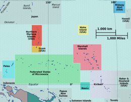
Kiribati, officially the Republic of Kiribati, is an island country in the Micronesia subregion of Oceania in the central Pacific Ocean. Its permanent population is over 119,000 as of the 2020 census, with more than half living on Tarawa atoll. The state comprises 32 atolls and one remote raised coral island, Banaba. Its total land area is 811 km2 (313 sq mi) dispersed over 3,441,810 km2 (1,328,890 sq mi) of ocean.

<span class="mw-page-title-main">History of Kiribati</span> Historical development of Kiribati

The islands which now form the Republic of Kiribati have been inhabited for at least seven hundred years, and possibly much longer. The initial Austronesian peoples’ population, which remains the overwhelming majority today, was visited by Polynesian and Melanesian invaders before the first European sailors visited the islands in the 17th century. For much of the subsequent period, the main island chain, the Gilbert Islands, was ruled as part of the British Empire. The country gained its independence in 1979 and has since been known as Kiribati.

<span class="mw-page-title-main">Gilbert Islands</span> 1976–1979 British colony in the Pacific

The Gilbert Islands are a chain of sixteen atolls and coral islands in the Pacific Ocean, about halfway between Papua New Guinea and Hawaii. They constitute the main part of the nation of Kiribati.

<span class="mw-page-title-main">Abaiang</span> Atoll of Kiribati

Abaiang, also known as Apaiang, Apia, and in the past, Charlotte Island, in the Northern Gilbert Islands, is a coral atoll of Kiribati, located in the west-central Pacific Ocean. Abaiang was the island of the first missionary to arrive in the Gilberts, Hiram Bingham II. Abaiang has a population of 5,872.

<span class="mw-page-title-main">Tabiteuea</span> Atoll in the Gilbert Islands, Kiribati

Tabiteuea is an atoll in the Gilbert Islands, Kiribati, farther south of Tarawa. This atoll is the second largest and the most populated of the Gilbert Islands after Tarawa. The atoll consists of one main island, Aanikai in the north, and several smaller islets in between along the eastern rim of the atoll. The atoll has a total land area of 38 km2 (15 sq mi), while the lagoon measures 365 km2 (141 sq mi). The population numbered 5,261 in 2015. The islanders have customary fishing practices related to the lagoon and the open ocean.

<span class="mw-page-title-main">Butaritari</span> Atoll in the Pacific Ocean island nation of Kiribati

Butaritari is an atoll in the Pacific Ocean island nation of Kiribati. The atoll is roughly four-sided. The south and southeast portion of the atoll comprises a nearly continuous islet. The atoll reef is continuous but almost without islets along the north side. Bikati and Bikatieta islets occupy a corner of the reef at the extreme northwest tip of the atoll. Small islets are found on reef sections between channels on the west side. The lagoon of Butaritari is deep and can accommodate large ships, though the entrance passages are relatively narrow. It is the most fertile of the Gilbert Islands, with relatively good soils and high rainfall. Butaritari atoll has a land area of 13.49 km2 (5.21 sq mi) and a population of 3,224 as of 2015. During World War II, Butaritari was known by United States Armed Forces as Makin Atoll, and was the site of the Battle of Makin. Locally, Makin is the name of a separate but closest atoll, 3 kilometres to the northeast of Butaritari, but close enough to be seen. These two atolls share a dialect of the Gilbertese language.

<span class="mw-page-title-main">Tarawa</span> Atoll in the South Pacific

Tarawa is an atoll and the capital of the Republic of Kiribati, in the Micronesia region of the central Pacific Ocean. It comprises North Tarawa, which has 6,629 inhabitants and much in common with other more remote islands of the Gilbert group, and South Tarawa, which has 56,388 inhabitants as of 2015, half of the country's total population. The atoll was the site of the Battle of Tarawa during World War II.

<span class="mw-page-title-main">South Tarawa</span> Island of the Republic of Kiribati

South Tarawa is the capital and hub of the Republic of Kiribati and home to more than half of Kiribati's population. The South Tarawa population centre consists of all the small islets from Betio in the west to Bonriki and Tanaea in the north-east, connected by the South Tarawa main road, with a population of 63,439 as of 2020.

<span class="mw-page-title-main">Betio</span> Town in Gilbert Islands, Kiribati

Betio is the largest township of Kiribati's capital city, South Tarawa, and the country's main port. The settlement is located on a separate islet at the extreme southwest of the atoll.

<span class="mw-page-title-main">Aranuka</span>

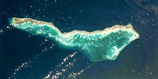
Aranuka is an atoll of Kiribati, located just north of the equator, in the Gilbert Islands. It has an area of 11.6 square kilometres and a population of 1,057 in 2010. By local tradition, Aranuka is the central island of the Gilbert group.

<span class="mw-page-title-main">Beru (atoll)</span>

Beru is an atoll in the Southern Gilbert Islands in the Pacific Ocean, part of the Republic of Kiribati. Beru was previously known as Eliza, Francis Island, Maria, Peroat, Peru Island or Sunday. It's part of a larger reef with the Nuka Lagoon at its center, and the nearest island is Nikunau. The Tabiang Lagoon is present in the north. Beru is home to 2,051 inhabitants. Due to sea surges, the atoll is experiencing coastal erosion along with damages to seawalls.

<span class="mw-page-title-main">Kuria (atoll)</span> Atoll in Central Gilbert Islands, Kiribati

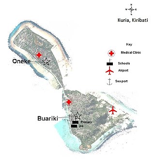
Kuria is an atoll, formed by a pair of islets, in the Central Gilbert Islands in Kiribati, northwest of Aranuka. The two islets, Buariki and Oneeke, are separated by a 20 metre wide channel on a shallow water platform, which is crossed by a bridge of the connecting road. The islands are surrounded by fringing reef which is broadest on the eastern side of Kuria. The population of Kuria was 1,046 in 2015.

<span class="mw-page-title-main">Maiana</span> Atoll in Gilbert Islands, Kiribati

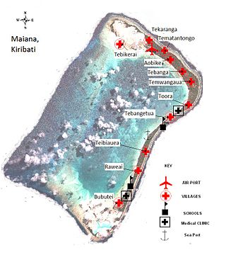
Maiana is an atoll in Kiribati and is one of the Central Gilbert Islands. Maiana is 44 kilometres (27 mi) south of the capital island of South Tarawa and has a population of 1,982 as of 2015. The northern and eastern sides of the atoll are a single island, whilst the western edge consists of submerged reefs and many uninhabited islets, all surrounding a lagoon. The atoll is 14 kilometres (8.7 mi) long and is very narrow, with an average width of less than 1 kilometre (0.62 mi) and a total land area of 16.72 square kilometres (6.46 sq mi).

<span class="mw-page-title-main">Nonouti</span>

Nonouti is an atoll and district of Kiribati. The atoll is located in the Southern Gilbert Islands, 38 km north of Tabiteuea, and 250 km south of Tarawa. The atoll is the third largest in the Gilbert Islands and is the island where the Roman Catholic religion was first established in Kiribati, in 1888.

<span class="mw-page-title-main">Onotoa</span>

Onotoa is an atoll of Kiribati. It is situated in the Gilbert Islands in the Pacific Ocean, 65 km (40 mi) from Tamana, the smallest island in the Gilberts. The population of Onotoa in the 2015 census was 1,393.

<span class="mw-page-title-main">Makin (atoll)</span>

Makin is the name of an atoll, chain of islands, located in the Pacific Ocean island nation of Kiribati. Makin is the northernmost of the Gilbert Islands, with a population of 1,990.

<span class="mw-page-title-main">Bikenibeu</span> Place in Gilbert Islands, Kiribati

Bikenibeu is a settlement in Kiribati. It is located close to the southeastern corner of the Tarawa atoll, part of the island country of Kiribati. It is part of a nearly continuous chain of settlements along the islands of South Tarawa, which are now linked by causeways. The low-lying atoll is vulnerable to sea level rise. Rapid population growth has caused some environmental problems. Kiribati's main government high school, King George V and Elaine Bernachi School, is located in Bikenibeu, as well as the Ministries of Environment and Education.

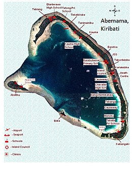
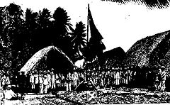
Tembinok', or Tem Binoka, was the Uea of Abemama, Aranuka and Kuria, in the Gilbert Islands, during the late 19th century.

<span class="mw-page-title-main">North Tarawa</span> A string of islets in Kiribati governed by the Eutan Tarawa Council

North Tarawa or in Gilbertese Tarawa Ieta, in the Republic of Kiribati, is the string of islets from Buariki at the northern tip of Tarawa atoll to Buota in the South, with a combined population of 6,629 as of 2015. It is administratively separate from neighbouring South Tarawa, and is governed by the Eutan Tarawa Council (ETC), based at Abaokoro.

<span class="mw-page-title-main">Coral reefs of Kiribati</span> Pacific Ocean Island chain

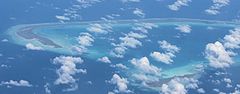
The Coral reefs of Kiribati consists of 32 atolls and one raised coral island, Banaba, which is an isolated island between Nauru and the Gilbert Islands. The islands of Kiribati are dispersed over 3.5 million km2 (1.4 million sq mi) of the Pacific Ocean and straddle the equator and the 180th meridian, extending into the eastern and western hemispheres, as well as the northern and southern hemispheres. 21 of the 33 islands are inhabited. The groups of islands of Kiribati are:

References

  1. 1 2 3 4 Hoiberg, Dale H., ed. (2010). "Abemama Atoll". Encyclopædia Britannica. Vol. I: A-ak Bayes (15th ed.). Chicago, IL: Encyclopædia Britannica Inc. pp.  27. ISBN   978-1-59339-837-8.
  2. 1 2 3 "8. Abemama" (PDF). Office of Te Beretitent - Republic of Kiribati Island Report Series. 2012. Retrieved 28 April 2015.
  3. Canby. Historic Places. p. 2
  4. "Geody.com, Abemama" . Retrieved 25 April 2013.
  5. 1 2 "Kiribati Census Report 2010 Volume 1" (PDF). National Statistics Office, Ministry of Finance and Economic Development, Government of Kiribati. Archived from the original (PDF) on 30 September 2013.
  6. Stanton, William (1975). The Great United States Exploring Expedition. Berkeley: University of California Press. pp.  245. ISBN   0520025571.
  7. Resture, Jane. "Abemama". Archived from the original on 6 June 2013. Retrieved 25 April 2013.
  8. Canby, Courtlandt. The Encyclopedia of Historic Places. (New York: Facts of File Publications, 1984) p. 2
  9. Premier Postal History. "Post Office List". Premier Postal Auctions. Retrieved 5 July 2013.
  10. In the South Seas (1896) & (1900) Chatto & Windus; republished by The Hogarth Press (1987)
  11. Fanny Stevenson incorrectly names the ship in The Cruise of the Janet Nichol among the South Sea Islands A Diary by Mrs Robert Louis Stevenson (first published 1914), republished 2004, editor, Roslyn Jolly (U. of Washington Press/U. of New South Wales Press)
  12. p.3 JAPANESE LAND ON ISLANDS IN GILBERT GROUPThe Mail (Adelaide, SA) Saturday 27 December 1941
  13. p. 179 Morison, Samuel Eliot History of United States Naval Operations in World War II: Aleutians, Gilberts and Marshalls, June 1942-April 1944 University of Illinois Press, 2001
  14. p.30 Rottman, Gordon L. US Special Warfare Units in the Pacific Theatre 1941-1945 Ospery Publishing 2005
  15. "Abemama Fact Sheet" (PDF). Government of Kiribati.[ permanent dead link ]
  16. "TABITEUEA NORTH 2008 Socio-Economic Profile" Part 2 of 4 Archived 14 September 2018 at the Wayback Machine . Strengthening Decentralized Governance in Kiribati Project , Ministry of Internal and Social Affairs (Kiribati). p. 48 (PDF p. 13/15). Part 1 is here Archived 14 September 2018 at the Wayback Machine .
  17. Talu, Alaima. "Towards Quality in Education" (Chapter 21, in Part IV: Social Issues). In: Van Trease, Howard (editor). Atoll Politics: The Republic of Kiribati. University of Canterbury MacMillan Brown Centre for Pacific Studies and University of the South Pacific, 1993. ISBN   095833000X, 9780958330008. p. 241