
Vesta is one of the largest objects in the asteroid belt, with a mean diameter of 525 kilometres (326 mi). It was discovered by the German astronomer Heinrich Wilhelm Matthias Olbers on 29 March 1807 and is named after Vesta, the virgin goddess of home and hearth from Roman mythology.

Tethys, or Saturn III, is the fifth-largest moon of Saturn, measuring about 1,060 km (660 mi) across. It was discovered by Giovanni Domenico Cassini in 1684, and is named after the titan Tethys of Greek mythology.
Tholins are a wide variety of organic compounds formed by solar ultraviolet or cosmic ray irradiation of simple carbon-containing compounds such as carbon dioxide, methane or ethane, often in combination with nitrogen or water. Tholins are disordered polymer-like materials made of repeating chains of linked subunits and complex combinations of functional groups, typically nitriles and hydrocarbons, and their degraded forms such as amines and phenyls. Tholins do not form naturally on modern-day Earth, but they are found in great abundance on the surfaces of icy bodies in the outer Solar System, and as reddish aerosols in the atmospheres of outer Solar System planets and moons.

Dawn is a retired space probe that was launched by NASA in September 2007 with the mission of studying two of the three known protoplanets of the asteroid belt: Vesta and Ceres. In the fulfillment of that mission—the ninth in NASA's Discovery Program—Dawn entered orbit around Vesta on July 16, 2011, and completed a 14-month survey mission before leaving for Ceres in late 2012. It entered orbit around Ceres on March 6, 2015. In 2017, NASA announced that the planned nine-year mission would be extended until the probe's hydrazine fuel supply was depleted. On November 1, 2018, NASA announced that Dawn had depleted its hydrazine, and the mission was ended. The derelict probe remains in a stable orbit around Ceres.
Christopher Thomas Russell is head of the Space Physics Center at the Institute of Geophysics and Planetary Physics (IGPP) at UCLA, professor in UCLA's Department of Earth, Planetary, and Space Sciences, and Director of the UCLA Branch of the California Space Grant Consortium. He received a B.Sc. from the University of Toronto in 1964 and a Ph.D. from UCLA in 1968. In 1977 he was awarded the James B. Macelwane Medal and in 2003 the John Adam Fleming Medal by the American Geophysical Union (AGU). He is also a Fellow of the AGU. Asteroid 21459 Chrisrussell was named after him in 2008. In 2017, he was awarded the NASA Distinguished Public Service Medal. He has three grandchildren.

Ceres is a dwarf planet in the middle main asteroid belt between the orbits of Mars and Jupiter. It was the first known asteroid, discovered on 1 January 1801 by Giuseppe Piazzi at Palermo Astronomical Observatory in Sicily, and announced as a new planet. Ceres was later classified as an asteroid and then a dwarf planet, the only one inside Neptune's orbit.

Isidis Planitia is a plain located within a giant impact basin on Mars, located partly in the Syrtis Major quadrangle and partly in the Amenthes quadrangle. At approximately 1,900 km (1,200 mi) in diameter, it is the third-largest confirmed impact structure on the planet, after the Hellas and Utopia basins. Isidis was likely the last major basin to be formed on Mars, having formed approximately 3.9 billion years ago during the Noachian period. Due to dust coverage, it typically appears bright in telescopic views, and was mapped as a classical albedo feature, Isidis Regio, visible by telescope in the pre-spacecraft era.

Crater counting is a method for estimating the age of a planet's surface based upon the assumptions that when a piece of planetary surface is new, then it has no impact craters; impact craters accumulate after that at a rate that is assumed known. Consequently, counting how many craters of various sizes there are in a given area allows determining how long they have accumulated and, consequently, how long ago the surface has formed. The method has been calibrated using the ages obtained by radiometric dating of samples returned from the Moon by the Luna and Apollo missions. It has been used to estimate the age of areas on Mars and other planets that were covered by lava flows, on the Moon of areas covered by giant mares, and how long ago areas on the icy moons of Jupiter and Saturn flooded with new ice.

Almost all water on Mars today exists as ice, though it also exists in small quantities as vapor in the atmosphere. What was thought to be low-volume liquid brines in shallow Martian soil, also called recurrent slope lineae, may be grains of flowing sand and dust slipping downhill to make dark streaks. While most water ice is buried, it is exposed at the surface across several locations on Mars. In the mid-latitudes, it is exposed by impact craters, steep scarps and gullies. Additionally, water ice is also visible at the surface at the north polar ice cap. Abundant water ice is also present beneath the permanent carbon dioxide ice cap at the Martian south pole. More than 5 million km3 of ice have been detected at or near the surface of Mars, enough to cover the whole planet to a depth of 35 meters (115 ft). Even more ice might be locked away in the deep subsurface. Some liquid water may occur transiently on the Martian surface today, but limited to traces of dissolved moisture from the atmosphere and thin films, which are challenging environments for known life. No evidence of present-day liquid water has been discovered on the planet's surface because under typical Martian conditions, warming water ice on the Martian surface would sublime at rates of up to 4 meters per year. Before about 3.8 billion years ago, Mars may have had a denser atmosphere and higher surface temperatures, potentially allowing greater amounts of liquid water on the surface, possibly including a large ocean that may have covered one-third of the planet. Water has also apparently flowed across the surface for short periods at various intervals more recently in Mars' history. Aeolis Palus in Gale Crater, explored by the Curiosity rover, is the geological remains of an ancient freshwater lake that could have been a hospitable environment for microbial life. The present-day inventory of water on Mars can be estimated from spacecraft images, remote sensing techniques, and surface investigations from landers and rovers. Geologic evidence of past water includes enormous outflow channels carved by floods, ancient river valley networks, deltas, and lakebeds; and the detection of rocks and minerals on the surface that could only have formed in liquid water. Numerous geomorphic features suggest the presence of ground ice (permafrost) and the movement of ice in glaciers, both in the recent past and present. Gullies and slope lineae along cliffs and crater walls suggest that flowing water continues to shape the surface of Mars, although to a far lesser degree than in the ancient past.

A planetary surface is where the solid or liquid material of certain types of astronomical objects contacts the atmosphere or outer space. Planetary surfaces are found on solid objects of planetary mass, including terrestrial planets, dwarf planets, natural satellites, planetesimals and many other small Solar System bodies (SSSBs). The study of planetary surfaces is a field of planetary geology known as surface geology, but also a focus on a number of fields including planetary cartography, topography, geomorphology, atmospheric sciences, and astronomy. Land is the term given to non-liquid planetary surfaces. The term landing is used to describe the collision of an object with a planetary surface and is usually at a velocity in which the object can remain intact and remain attached.

Several bright surface features were discovered on the dwarf planet Ceres by the Dawn spacecraft in 2015.

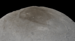
Ahuna Mons is the largest mountain on the dwarf planet and asteroid Ceres. It protrudes above the cratered terrain, is not an impact feature, and is the only mountain of its kind on Ceres. Bright streaks run top to bottom on its slopes which are thought to be salt, similar to the better known Cererian bright spots, and likely resulted from cryovolcanic activity from Ceres's interior. It is named after the traditional post-harvest festival Ahuna of the Sümi Naga people of India. In July 2018, NASA released a comparison of physical features, including Ahuna Mons, found on Ceres with similar ones present on Earth.

Occator is an impact crater located on Ceres, the largest object in the main asteroid belt that lies between the orbits of Mars and Jupiter, that contains "Spot 5", the brightest of the bright spots observed by the Dawn spacecraft. It was known as "Region A" in ground-based images taken by the W. M. Keck Observatory on Mauna Kea.
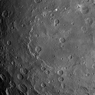
Kerwan is the largest confirmed crater and one of the largest geological features on Ceres. It was discovered on February 19, 2015 from Dawn images as it approached Ceres. The crater is distinctly shallow for its size, and lacks a central peak. A central peak might have been destroyed by a 15-kilometer-wide crater at the center of Kerwan. The crater is likely to be young relative to the rest of Ceres's surface, as Kerwan has largely obliterated the cratering in the southern part of Vendimia Planitia.
Yalode is the second-largest confirmed crater on Ceres, after Kerwan. It is adjacent to another large crater, Urvara and serves as the namesake for the Yalode Quadrange. Yalode named after the Dahomeyan (Fon) deity of the yam harvest, Yalodé; the name Yalode was officially approved by the International Astronomical Union (IAU) on 3 July 2015.

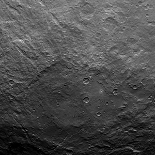
Coniraya is a large, shallow crater on the dwarf planet Ceres. It is the namesake for the Coniraya Quadrangle.

Northeast Syrtis is a region of Mars once considered by NASA as a landing site for the Mars 2020 rover mission. This landing site failed in the competition with Jezero crater, another landing site dozens of kilometers away from Northeast Syrtis. It is located in the northern hemisphere of Mars at coordinates 18°N,77°E in the northeastern part of the Syrtis Major volcanic province, within the ring structure of Isidis impact basin as well. This region contains diverse morphological features and minerals, indicating that water once flowed here. It may be an ancient habitable environment; microbes could have developed and thrived here.
Roger Jay Phillips was an American geophysicist, planetary scientist, and professor emeritus at the Washington University in St. Louis. His research interests included the geophysical structure of planets, and the use of radar and gravity to investigate the surfaces and interiors of the planets.

Brett W. Denevi is a Planetary Geologist at the Johns Hopkins University Applied Physics Laboratory. She is currently serving as the Deputy Principal Investigator for the Lunar Reconnaissance Orbiter Camera. In 2014, Asteroid 9026 was named Denevi in her honor. She is the recipient of seven NASA group achievement awards and in 2014 she was awarded a NASA Early Career Fellowship. In 2015, she received a Maryland Academy of Sciences Outstanding Young Scientist Award.


