Related Research Articles

The Northwest Territories is a federal territory of Canada. At a land area of approximately 1,144,000 km2 (442,000 sq mi) and a 2016 census population of 41,790, it is the second-largest and the most populous of the three territories in Northern Canada. Its estimated population as of 2020 is 45,161. Yellowknife is the capital, most populous community, and only city in the territory with a population of 19,569 as of the 2016 census. It became the territorial capital in 1967, following recommendations by the Carrothers Commission.

Victoria Island is a large island in the Arctic Archipelago that straddles the boundary between Nunavut and the Northwest Territories of Canada. It is the eighth largest island in the world, and at 217,291 km2 (83,897 sq mi) in area, it is Canada's second largest island. It is nearly double the size of Newfoundland (111,390 km2 [43,008 sq mi]), and is slightly larger than the island of Great Britain (209,331 km2 [80,823 sq mi]) but smaller than Honshu (225,800 km2 [87,182 sq mi]). It contains the world's largest island within an island within an island. The western third of the island lies in the Inuvik Region of the Northwest Territories; the remainder is part of Nunavut's Kitikmeot Region.
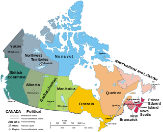
The provinces and territories of Canada are sub-national divisions within the geographical areas of Canada under the jurisdiction of the Canadian Constitution. In the 1867 Canadian Confederation, three provinces of British North America—New Brunswick, Nova Scotia, and the Province of Canada —were united to form a federated colony, becoming a sovereign nation in the next century. Over its history, Canada's international borders have changed several times, and the country has grown from the original four provinces to the current ten provinces and three territories. Together, the provinces and territories make up the world's second-largest country by total area.

Northern Canada, colloquially the North, is the vast northernmost region of Canada variously defined by geography and politics. Politically, the term refers to three territories of Canada: Yukon, Northwest Territories, and Nunavut. Similarly, the Far North may refer to the Canadian Arctic: the portion of Canada that lies north of the Arctic Circle, east of Alaska and west of Greenland. This area covers about 39% of Canada's total land area, but has less than 1% of Canada's population.

Rupert's Land, or Prince Rupert's Land, was a territory in British North America comprising the Hudson Bay drainage basin, a territory in which a commercial monopoly was operated by the Hudson's Bay Company for 200 years from 1670 to 1870. The area once known as Rupert's Land is now mainly a part of Canada, but a small portion is now in the United States. It was named after Prince Rupert of the Rhine, a nephew of Charles I and the first Governor of the Hudson's Bay Company (HBC). In December 1821, the HBC monopoly was extended from Rupert's Land to the Pacific coast.

British North America comprised the British Empire's colonial territories in North America from 1783 to 1907, not including the Caribbean. The Atlantic island of Bermuda was grouped with the Maritimes from 1783 until the formation of the Canadian dominion, and thereafter generally with the colonies in the British West Indies, although the Church of England continued to place Bermuda under the Bishop of Newfoundland until 1919. The term was first used informally in 1783, but it was uncommon before the Report on the Affairs of British North America (1839), called the Durham Report. These territories today form modern-day Canada and the Pacific Northwest of the United States.
The North-Western Territory was a region of British North America extant until 1870 and named for where it lay in relation to Rupert's Land.

Events from the year 1880 in Canada.
Crown-Indigenous Relations and Northern Affairs Canada is the department of the Government of Canada responsible for Canada's northern lands and territories, and one of two departments with responsibility for policies relating to Indigenous peoples in Canada.

John Hornby (1880–1927) was an English explorer, best known for his expeditions in the Arctic region of northern Canada, notably in the "Barren Lands" in the Northwest Territories of Canada. Hornby was born to a wealthy family in England; his father, A. N. Hornby, twice captained England in Test cricket. John migrated to Canada in 1904.
The British Arctic territories, now known as the Arctic Archipelago were claimed by the United Kingdom in North America. The region was part of British North America.
The history of the Northwest Territories covers the period from thousands of years ago to the present day. Prior to European colonization, the lands that encompass present-day Northwest Territories were inhabited for millennia by several First Nations. European explorers and fur traders began to explore the region since the late-16th century. By the 17th century, the British laid claim to both the North-Western Territory and Rupert's Land; and granted the Hudson's Bay Company a commercial fur trade monopoly over the latter region.

The history of post-confederation Canada began on July 1, 1867, when the British North American colonies of Canada, New Brunswick, and Nova Scotia were united to form a single Dominion within the British Empire. Upon Confederation, the United Province of Canada was immediately split into the provinces of Ontario and Quebec. The colonies of Prince Edward Island and British Columbia joined shortly after, and Canada acquired the vast expanse of the continent controlled by the Hudson's Bay Company, which was eventually divided into new territories and provinces. Canada evolved into a fully sovereign state by 1982.
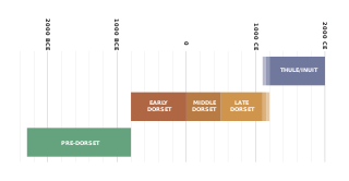
The history of Nunavut covers the period from the arrival of the Paleo-Eskimo thousands of years ago to present day. Prior to the colonization of the continent by Europeans, the lands encompassing present-day Nunavut were inhabited by several historical cultural groups, including the Pre-Dorset, the Dorsets, the Thue and their descendants, the Inuit.

Nunavut is the newest, largest, and most northerly territory of Canada. It was separated officially from the Northwest Territories on April 1, 1999, via the Nunavut Act and the Nunavut Land Claims Agreement Act, though the boundaries had been drawn in 1993. The creation of Nunavut resulted in the first major change to Canada's political map since incorporating the province of Newfoundland in 1949.
The Nunavut Land Claim Agreement was signed on May 25, 1993, in Iqaluit, by representatives of the Tunngavik Federation of Nunavut, the Government of Canada and the Government of the Northwest Territories. This agreement gave the Inuit of the central and eastern Northwest Territories a separate territory called Nunavut. It is the largest Aboriginal land claim settlement in Canadian history. The NLCA consists of 42 chapters, which addresses a broad range of political and environmental rights and concerns including wildlife management and harvesting rights, land, water and environmental management regimes, parks and conservation areas, heritage resources, public sector employment and contracting, and a range of other issues. The agreement indicates two areas that are the focus of the agreement: the first area consists of the Arctic islands and the mainland eastern Arctic, and their adjacent marine areas; the second area includes the Belcher Islands, its associated islands and adjacent marine areas.

The 1763 Treaty of Paris ended the major war known by Americans as the French and Indian War and by Canadians as the Seven Years' War / Guerre de Sept Ans, or by French-Canadians, La Guerre de la Conquête. It was signed by Great Britain, France and Spain, with Portugal in agreement. Preferring to keep Guadeloupe, France gave up Canada and all of its claims to territory east of the Mississippi River to Britain. With France out of North America this dramatically changed the European political scene on the continent.
A number of states and polities formerly claimed colonies and territories in Canada prior to the evolution of the current provinces and territories under the federal system. North America prior to colonization was occupied by a variety of indigenous groups consisting of band societies typical of the sparsely populated North, to loose confederacies made up of numerous hunting bands from a variety of ethnic groups, to more structured confederacies of sedentary farming villages, to stratified hereditary structures centred on a fishing economy. The colonization of Canada by Europeans began in the 10th century, when Norsemen explored and, ultimately unsuccessfully, attempted to settle areas of the northeastern fringes of North America. Early permanent European settlements in what is now Canada included the late 16th and 17th century French colonies of Acadia and Canada, the English colonies of Newfoundland (island) and Rupert's Land, the Scottish colonies of Nova Scotia and Port Royal.
The Arctic policy of Canada includes both the foreign policy of Canada in regard to the Arctic region and Canada's domestic policy towards its Arctic territories. This includes the devolution of powers to the territories. Canada's Arctic policy includes the plans and provisions of these regional governments. It encompasses the exercise of sovereignty, social and economic development, the protection of the environment, and the improving and devolving of governance.

The Deed of Surrender or Rupert's Land and North-Western Territory Order was an 1870 British order-in-council that transferred ownership of Rupert's Land and the North-Western Territory from the Hudson's Bay Company (HBC) to the newly created Dominion of Canada. The Deed ended just over 200 years of HBC control over the lands and began western Canadian expansion. While the Deed of Surrender was actually only a schedule in the order, the name "Deed of Surrender" is generally understood to refer to the document on whole. Often confused with Rupert's Land Act, 1868, the Deed is different as the act only expressed that the United Kingdom and Canada permitted the transfer but did not settle on the details of exchange with HBC which were outline in the Deed of Surrender.
References
- ↑ "Adjacent Territories Order". July 31, 1880. Retrieved December 28, 2020.
- ↑ Rothwell, Donald. "The Canadian-U.S. Northwest Passage Dispute: A Reassessment" (PDF). core.ac.uk. Cornell University. Retrieved December 26, 2020.
- ↑ Smith, Gordon. "The Transfer of Arctic Territories from Great Britain to Canada in 1880, and some Related Matters, as seen in Official Correspondence" (PDF). caid.ca. Christian Aboriginal Infrastructure Developments. Retrieved December 26, 2020.
| | This Canadian history article is a stub. You can help Wikipedia by expanding it. |