Administrative divisions of Nazi Germany

Last updated

De facto administrative divisions of Nazi Germany in 1944. NS administrative Gliederung 1944.png
De facto administrative divisions of Nazi Germany in 1944.
De jure administrative divisions of Nazi Germany in 1944 KarteDesGrossdeutschenReichesJan1944.png
De jure administrative divisions of Nazi Germany in 1944
Lander (states) of Weimar Germany, 1919-1937. Karte des Deutschen Reiches, Weimarer Republik-Drittes Reich 1919-1937.svg
Länder (states) of Weimar Germany, 1919–1937.
Map of NS administrative division in 1944 Greater German Reich NS Administration 1944 Variant.png
Map of NS administrative division in 1944
Gaue of the Nazi Party in 1926, 1928, 1933, 1937, 1939 and 1943. Nsdap gaue english.png
Gaue of the Nazi Party in 1926, 1928, 1933, 1937, 1939 and 1943.

The Gaue (singular: Gau) were the main administrative divisions of Nazi Germany from 1934 to 1945.

Contents

The Gaue were formed in 1926 as Nazi Party regional districts in Weimar Germany based on the territorial changes after the First World War. [1] The Gau system was established in 1934 as part of the Gleichschaltung process, replacing the de jure system of Länder (states) and Prussian provinces, which held no administrative purpose since the Enabling Act of 1933 and were reduced to rudimentary bodies. Each Gau was headed by an administrative leader, the Gauleiter , a high-ranking Nazi Party official with near-autocratic powers.

Germany consisted of 32 Gaue in 1934, eventually peaking at 42 Gaue with regions occupied in 1938 to early 1939 (Austria, Sudetenland, Memelland) and conquered during the Second World War incorporated into existing Gaue or organised as Reichsgaue , a special type of Gau where the Gauleiter also carried the position of Reichsstatthalter . [1] [2] The Gaue system was dissolved on May 8, 1945, following the surrender of Nazi Germany.

Etymology

Gau is an archaic Germanic term for a region within a country, often a former or actual province, and used in Medieval times as roughly corresponding to an English shire. The term was revived by the Nazi Party in the 1920s as the name given to the regional associations of the party in Weimar Germany, based mainly along state and district lines.

Gaue, Reichsgaue and Länder

The Gaue existed parallel to the German states, the Länder, and Prussian provinces throughout the Nazi period. Pro forma, the Administrative divisions of Weimar Germany were left in place. The plan to abolish the Länder was ultimately given up because Hitler shrank away from structural reforms, a so-called Reichsreform, fearing it would upset local party leaders. For the same reason, the borders of the Gaue remained unchanged within Germany throughout this time. The Gaue were only enlarged through the adding of occupied territories after 1938. [3] While the Länder continued to exist, the real power on local level did lie with the Gauleiters, not the Minister Presidents of the German states. The Gauleiters were directly appointed by Hitler and only answerable to him. In practice, interference from above was rare and their power almost absolute. [1]

Gaue established in 1934

English nameGerman nameHeadquartersEstablishedNotes
Baden Baden Karlsruhe 1934Formed from the state of Baden; in 1940-45 the Gau included the former French départements of Bas-Rhin and Haut-Rhin and was renamed Baden-Elsaß
Bayreuth Bayreuth Bayreuth 1934Formed from the eastern part of the state of Bavaria; originally named Bayrische Ostmark, renamed Gau Bayreuth in 1942; also incorporated parts of Czechoslovakia from 1938
Cologne-Aachen Köln-Aachen Cologne 1934Formed from the north-central part of the Prussian province of the Rhine
Düsseldorf Düsseldorf Düsseldorf 1934Formed from the northern half of the Prussian province of the Rhine
East Prussia Ostpreußen Königsberg 1934Formed from the Prussian Province of East Prussia; from 1939 also included territories annexed from Poland
Eastern Hanover Ost-Hannover Lüneburg 1934Formed from the northern, central, and eastern parts of the Prussian Province of Hanover
Electoral Hesse Kurhessen Kassel 1934Formed from the northern half of the Prussian province of Hesse-Nassau
Essen Essen Essen 1934Formed from the northern tip of the Prussian province of the Rhine
Franconia Franken Nuremberg 1934Formed from the central part of the state of Bavaria
Greater Berlin Groß-Berlin Berlin 1934Formed from the Prussian province of Greater Berlin
Halle-Merseburg Halle-Merseburg Halle 1934Formed from the southern half of the Prussian Province of Saxony
Hamburg Hamburg Hamburg 1934Formed from the Free Hanseatic City of Hamburg
Hesse-Nassau Hessen-Nassau Frankfurt am Main 1934Formed from the People's State of Hesse and the southern half of the Prussian province of Hesse-Nassau
Koblenz-Trier Koblenz-Trier Koblenz 1934Formed from the southern half of the Prussian province of the Rhine; renamed Gau Moselland in 1942, following the incorporation of the formerly independent country of Luxembourg
Magdeburg-Anhalt Magdeburg-Anhalt Dessau 1934Formed from the Free State of Anhalt and the northern half of the Prussian Province of Saxony
Main-Franconia Mainfranken Würzburg 1934Formed from the northwestern part of the state of Bavaria
March of Brandenburg Mark Brandenburg Berlin 1934Formed from the Prussian province of Province of Brandenburg
Mecklenburg Mecklenburg Schwerin 1934Formed from the Free State of Mecklenburg-Strelitz and the Free State of Mecklenburg-Schwerin
Munich-Upper Bavaria München-Oberbayern Munich 1934Formed from the southeastern part of the state of Bavaria
Pomerania Pommern Stettin 1934Formed from the Prussian Province of Pomerania
Saar-Palatinate Saarpfalz Neustadt an der Weinstraße 1934Formed from the Bavarian Palatinate and the Prussian Saarland; renamed Gau Westmark in 1940 after the incooperation of parts of Lorraine
Saxony Sachsen Dresden 1934Formed from the state of Saxony
Schleswig-Holstein Schleswig-Holstein Kiel 1934Formed from the Prussian Province of Schleswig-Holstein, the Free City of Lübeck and territory belonging to the Free State of Oldenburg
Silesia Schlesien Breslau 1934Formed from the Prussian provinces of Upper Silesia (with annexed parts of Poland since 1939) and Lower Silesia. In 1938 the provinces were also united into one; in 1941 both the province and the Gau were split in two.
Southern Hanover-Brunswick Südhannover-Braunschweig Hanover 1934Formed from the Free State of Brunswick and the southern and western parts of the Province of Hanover
Swabia Schwaben Augsburg 1934Formed from the southwestern part of the state of Bavaria
Thuringia Thüringen Weimar 1934Formed from the state of Thuringia and adjacent territory from the Prussian Province of Saxony
Weser-Ems Weser-Ems Oldenburg 1934Formed from the Free State of Oldenburg (excluding outlying territories), the state Free Hanseatic City of Bremen and the far western part of the Prussian Province of Hanover
Westphalia-North Westfalen-Nord Münster 1934Formed from the Free State of Lippe, the Free State of Schaumburg-Lippe and the northern half of the Prussian Province of Westphalia
Westphalia-South Westfalen-Süd Dortmund 1934Formed from the southern half of the Prussian Province of Westphalia
Württemberg-Hohenzollern Württemberg-Hohenzollern Stuttgart 1934Formed from the Free People's State of Württemberg and the Prussian Province of Hohenzollern

Reichsgaue established in the 1930s

New Reichsgaue were established after the Anschluss of Austria and the incorporation of Sudetenland following the Munich Agreement. Southern parts of Czechoslovakia also gained by the Munich Agreement were not made part of Reichsgau Sudetenland, but incorporated into the northern Reichsgaue of former Austria.

English nameGerman nameHeadquartersEstablishedNotes
Carinthia Kärnten Klagenfurt 1938Formed from the former Austrian federal state of Carinthia and Eastern Tyrol, included from 1941 was Upper Carniola (German : Oberkrain), Slovenia
Lower Danube Niederdonau Krems an der Donau 1938Formed from the former Austrian federal state of Niederösterreich and northern Burgenland; included from 1939 were parts of southern Moravia. In 1943 Hitler toured the Gau and told Gauleiter Hugo Jury that the capital would be Brünn (Brno) in the near future. [4]
Salzburg Salzburg Salzburg 1938Formed from the former Austrian federal state of Salzburg
Styria Steiermark Graz 1938Formed from the former Austrian federal state of Styria and southern part of Burgenland; included from 1941 was Lower Styria, Slovenia.
Sudetenland Sudetenland Reichenberg 1938Formed from the predominantly German speaking parts of Czechoslovakia which were ceded to Germany after the Munich Agreement
Tyrol-Vorarlberg Tirol-Vorarlberg Innsbruck 1938Formed from the former Austrian federal state of Vorarlberg and the northern part of Tyrol
Upper Danube Oberdonau Linz 1938Formed from the former Austrian federal state of Oberösterreich and Ausseerland, a part of Styria; included from 1939 were parts of southern Bohemia
Vienna Wien Vienna 1938Formed from the former Austrian federal state of Vienna and surrounding parts of former Niederösterreich

Reichsgaue established during the Second World War

Of the territories annexed from Poland and the Free City of Danzig in 1939, Reichsgau Wartheland and Reichsgau Danzig-West Prussia were created. Annexed territories of pre-war Poland not within these two Reichsgaue were incorporated into the neighboring Gaue East Prussia and Silesia. The Grand Duchy of Luxembourg as well as Alsace-Lorraine, annexed from pre-war France in 1940, were attached to the bordering Southwestern Gaue of Nazi Germany.

English nameGerman nameHeadquartersEstablishedNotes
Danzig–West Prussia Danzig–Westpreußen Danzig 1939Formed in the Free City of Danzig and the Polish region of the Pomeranian Voivodeship, which were both occupied by Germany in 1939, as well as the pre-1939 German Governorate of West Prussia within then East Prussia
Wartheland Wartheland Posen 1939Formed primarily in the Polish region of the Poznań Voivodeship and incorporated areas of surrounding Voivodeships after the German occupation of Poland. Called Reichsgau Posen until January 1940, when it was renamed for the Warthe (Warta) river.

Auslandsgau

There was also an extraterritorial Gau named Auslandsorganisation for party members overseas. Its headquarters were in Berlin. This Auslandsgau was considered to be the 43rd Gau of Nazi Germany.

Protectorate of Bohemia and Moravia

Government districts within the protectorate. Protectorate Of Bohemia and Moravia.png
Government districts within the protectorate.

On 15 March 1939, German troops invaded and occupied the rump state of Czechoslovakia that had existed after the Sudetenland had been annexed by Germany following the Munich Conference. On 16 March, Hitler signed a decree declaring the German-occupied territories of Bohemia and Moravia to be incorporated into "Greater Germany". They were not formally annexed, but were placed under the protection of Germany as the Protectorate of Bohemia and Moravia. Ethnic Germans living in the area became citizens of Germany. A separate native government was retained, but a German Reichsprotektor was appointed who wielded effective executive control over the territory. [5]

Two separate structures for its territorial administration existed within the protectorate. [6] Administration of the government of the protectorate was divided into two Länder (states): Bohemia and Moravia, which were in turn sub-divided into a number of smaller units. The Nazi Party divided the area into four separate party districts but, instead of creating four new Gaue, they were assigned organizationally to the surrounding Party districts: Gau Bayreuth, Reichsgau Sudetenland, Reichsgau Lower Danube and Reichsgau Upper Danube. [6] These two separate government and party divisions continued to co-exist in the protectorate for the entire duration of its existence. [6]

General Government

The General Government in August 1941. General Government for the occupied Polish territories.png
The General Government in August 1941.

Following the German invasion and conquest of Poland, Hitler signed a decree on 12 October 1939, declaring that the Polish territories occupied by the Germans would be placed under the administration of a Governor-General and would be known as the General Government of the Occupied Polish Territories. This came into effect on 26 October. On 22 July 1941, following the German invasion of the Soviet Union and the occupation of Eastern Galicia, Hitler signed a decree declaring that the region would be administered by the Governor-General of Poland from 1 August. [7]

While theoretically outside the boundaries of the Reich proper, the General Government was considered part of "Greater Germany" by Nazi officials as an "autonomous" region (i.e., not directly subordinated to the Berlin government). [8] It was not a protectorate, but a colony, outside the Reich and its law. Its Polish inhabitants were effectively stateless and without rights. [9]

It was sub-divided into four Distrikte (districts).

After the invasion of the Soviet Union in 1941, a fifth district was added, created out of former territories of Austrian Galicia:

Operational Zones

After the overthrow of Benito Mussolini, the Italian government secretly began negotiations with the Allies about Italy switching sides to the Allied camp. In retaliation the Germans occupied large parts of Italy, freed Mussolini, and re-installed him as the puppet ruler of a new fascist state in those parts that were occupied by the German Army. While officially in control over all the areas held by erstwhile Fascist Italy, large parts in the northeast located between Switzerland and the Adriatic were re-organized as Operational Zones (Operationszonen). These were informally annexed by Germany, and attached to adjacent Gaue of the Reich. There were two such Operational Zones:

English nameGerman nameHeadquartersEstablishedNotes
Operational Zone of the Adriatic Littoral Operationszone Adriatisches Küstenland (OZAK) Triest 1943Formed out of the Italian-occupied areas of Yugoslav Slovenia, the Istrian peninsula, Rijeka (Fiume), Friuli and Gorizia provinces. Attached (not incorporated) to Reichsgau Carinthia.
Operational Zone of the Alpine Foothills Operationszone Alpenvorland (OZAV) Bozen 1943Formed out of former South Tyrol, Italian Trentino, and adjacent smaller parts of northeastern Italy. Attached (not incorporated) to Reichsgau Tirol-Vorarlberg.

In a supplementary OKW order dated 10 September 1943, Hitler decrees on the establishment of further Operational Zones in Northern Italy, which were to stretch all the way to the French border. [11] Unlike Alpenvorland and Küstenland, these zones did not immediately receive high commissioners (oberster kommissar) as civilian advisors, but were military regions where the commander was to exercise power on behalf of Army Group B. [11] Operation zone Nordwest-Alpen (Northwest Alps) or Schweizer Grenze (Swiss Frontier) was located between the Stelvio Pass and Monte Rosa and was to contain wholly the Italian provinces of Sondrio and Como and parts of the provinces of Brescia, Varese, Novara and Vercelli. [12] The zone of Französische Grenze (French Frontier) was to encompass areas west of Monte Rosa and was to incorporate the province of Aosta and a part of the province of Turin, and presumably also the provinces of Cuneo and Imperia. [12]

Planned future districts

The Nazi government openly pursued and practiced aggressive territorial expansionism, intending to further extend the already greatly increased territorial base of the German state. [13] In anticipation of these expected future territorial enlargements, potential new districts were theorized upon at length by Nazi ideologists, government officials, and territorial planning departments. These expansions were intended to take place in two distinct ways:

Territorial expansion into Eastern Europe

To expand the Lebensraum of the German people, the Slavic populations of Eastern Europe were intended to be wiped out through a combined process of extermination, expulsion, starvation, and enslavement that would effectively Germanize these territories in the long run. [14] Nazi racial offices planned that the colonization with Germanic peoples of these conquered eastern territories was to proceed most intensively in the three so-called Siedlungsmarken (Settlement marches) or Reichsmarken of Ingermannland (Ingria), the Memel-Narew area, and the Southern Ukraine and the Crimean peninsula. [15] The latter of these was intended to be newly re-organized as a Gotengau (Gau of the Goths), in honour of the Crimean Goths who had at one point dwelled there. [15] Of the Baltic countries, Peipusland was proposed as a replacement-name for Estonia, and Dünaland for Latvia. [16]

In a conference on July 16, 1941, discussing the future organization of the conquered Soviet territories, Hitler stated his intention to turn not only the areas mentioned above but also the entire Baltic region (Reichskommissariat Ostland), the Volga German colony, and the Baku district into future Reichsgebieten (Reich territories). [17] On 3 November 1941, he also elaborated on the toponymic aspect of Germanizing the east:

In the eastern territories I will replace the Slavic geographic names with German names. The Crimea could, for instance, be called Gotenland. [...] We need names that will confirm our rights which go back for two thousand years.

Adolf Hitler, [18]
Envisaged territory of a Prinz-Eugen-Gau. South german buffer state 1941.png
Envisaged territory of a Prinz-Eugen-Gau.

The central and upper Vistula valley within the General Government were variously discussed as having to become either a single Vandalengau (Gau of the Vandals) or 3-5 other new Reichsgaue. [19] An earlier proposal from 1939 also advocated for the creation of a Reichsgau Beskidenland , which was to stretch from the area to the west of Kraków to the San river in the east. [20] In Axis-occupied Yugoslavia, Sepp Janko, Nazi representative of Danube Swabian interests, pushed for the establishment of a Reichsgau Banat or Prinz-Eugen-Gau, which would have encompassed the Yugoslavian territories of Bačka, Banat, parts of Transylvania (Siebenbürgen) and Baranya. [21]

Annexation of the Germanic countries

The Nazi racial categorization of the ethnic groups of Europe classified the Northern Europeans, especially those closely related to the Germans (itself considered to be a single nationality of which Swiss and Austrians were nothing but sub-regional identities at best) such as the Dutch, the Flemings, the Danish, Norwegians, Swedish, and English as part of a superior Aryan-Nordic master race (Herrenrasse). [22] [23] Following the integration of Austria into a Greater Germany (Großdeutschland), Hitler decided that he would follow the same policy in the future for all other countries that he regarded by virtue of their perceived racial qualifications as "belonging" to the Reich. [24] This meant that the Low Countries, at least the German-speaking parts of Switzerland, Liechtenstein [25] and the Scandinavian states were eventually to be annexed into a much larger Greater Germanic Reich (Großgermanisches Reich) by being broken up into smaller state and party administrative units, such as Denmark into a Gau Nordmark, [26] and the Netherlands into a Gau Westland . [27]

Afterwards the very notion of these countries ever having been independent or separate from the rest of the Reich was to be suppressed indefinitely. [28] The objective called for the inauguration of a new period of rapidly enforced Gleichschaltung, the end result of which would be that aside from their local "language dialects" these countries were to become perfect duplicates of National Socialist Germany in all political and social respects. [29]

In addition it was intended to revert the western borders of Germany with France to those of the late-medieval Holy Roman Empire. A strip of eastern France from the mouth of the Somme to Lake Geneva (the so-called "closed" or "forbidden" zone of German occupied France) was prepared to be annexed to the German Reich as Reichsgau Burgund, with Nancy (Nanzig) as the capital. [30]

See also

Related Research Articles

<span class="mw-page-title-main">Reichsgau Wartheland</span> Nazi administrative subdivision

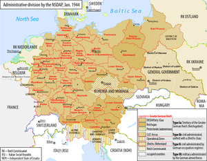
The Reichsgau Wartheland was a Nazi German Reichsgau formed from parts of Polish territory annexed in 1939 during World War II. It comprised the region of Greater Poland and adjacent areas. Parts of Warthegau matched the similarly named pre-Versailles Prussian province of Posen. The name was initially derived from the capital city, Posen (Poznań), and later from the main river, Warthe (Warta).

<i>Gauleiter</i> Third highest political rank of the Nazi Party

A Gauleiter was a regional leader of the Nazi Party (NSDAP) who served as the head of a Gau or Reichsgau. Gauleiter was the third-highest rank in the Nazi political leadership, subordinate only to Reichsleiter and to the Führer himself. The position was effectively abolished with the fall of the Nazi regime on 8 May 1945.

<span class="mw-page-title-main">Reichsgau Danzig-West Prussia</span> Administrative division of Nazi Germany

Reichsgau Danzig-West Prussia was an administrative division of Nazi Germany created on 8 October 1939 from annexed territory of the Free City of Danzig, the Greater Pomeranian Voivodship, and the Regierungsbezirk West Prussia of Gau East Prussia.

<span class="mw-page-title-main">Protectorate of Bohemia and Moravia</span> Partially-annexed territory of Germany in Central Europe (1939–45)

The Protectorate of Bohemia and Moravia was a partially-annexed territory of Nazi Germany that was established on 16 March 1939 after the German occupation of the Czech lands. The protectorate's population was mostly ethnic Czech.

<span class="mw-page-title-main">Ostmark (Austria)</span> Nazi name for Austria (1938–1942)

Ostmark was a name that referred historically to the Margraviate of Austria, a medieval frontier march. It was also used in Nazi propaganda from 1938 to 1942 to refer to the formerly independent Federal State of Austria after the Anschluss with Nazi Germany. From the Anschluss until 1939, the official name used was Land Österreich.

<span title="German-language text"><i lang="de">Reichsgau</i></span> Nazi administrative subdivision

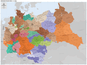
A Reichsgau was an administrative subdivision created in a number of areas annexed by Nazi Germany between 1938 and 1945.

<i>Gau</i> (territory) German term for a region within a country

Gau is a Germanic term for a region within a country, often a former or current province. It was used in the Middle Ages, when it can be seen as roughly corresponding to an English shire. The administrative use of the term was revived as a subdivision during the period of Nazi Germany in 1933–1945. It still appears today in regional names, such as the Rheingau or Allgäu.

<span class="mw-page-title-main">Josef Bürckel</span> German Nazi politician, Gauleiter of Vienna

Joseph Bürckel was a German Nazi politician and a member of the German parliament. He was an early member of the Nazi Party and was influential in the rise of the National Socialist movement. He played a central role in the German acquisition of the Saarland and Austria. He held the posts of Gauleiter and Reichsstatthalter in both Gau Westmark and Reichsgau Vienna.

<span class="mw-page-title-main">Gau Swabia</span> Administrative division of Nazi Germany

Gau Swabia, formed on 1 October 1928, was an administrative division of Nazi Germany in Swabia, Bavaria, from 1933 to 1945. From 1928 to 1933, it was the regional subdivision of the Nazi Party in that area.

<span class="mw-page-title-main">States of the Weimar Republic</span> Federated states of the Weimar Republic

The States of the Weimar Republic were the first-level administrative divisions and constituent states of the German Reich during the Weimar Republic era. The states were established in 1918 following the German Revolution upon the conclusion of World War I, and based on the 22 constituent states of the German Empire that abolished their local monarchies. The new states continued as republics alongside the three pre-existing republican city-states within the new Weimar Republic, adopting the titles Freistaat or Volksstaat.

<span class="mw-page-title-main">Reichsgau Steiermark</span>

The Reichsgau Styria was an administrative division of Nazi Germany consisting of areas in Styria, Lower Styria and southern parts of Burgenland. It existed from 1938 to 1945.

<span class="mw-page-title-main">Reichsgau Kärnten</span>

The Reichsgau Carinthia was an administrative division of Nazi Germany in Carinthia and East Tyrol and Upper Carniola in Slovenia. It existed from 1938 to 1945.

<span class="mw-page-title-main">Reichsgau Oberdonau</span>

The Reichsgau Upper Danube was an administrative division of Nazi Germany, created after the Anschluss in 1938 and dissolved in 1945. It consisted of what is today Upper Austria, parts of Southern Bohemia, and a small part of the Salzkammergut which was annexed from Styria.

<span class="mw-page-title-main">Reichsgau Wien</span>

The Reichsgau Vienna was an administrative division of Nazi Germany based in Vienna, Austria. It existed between 1938 and 1945. Parts of Lower Austria were annexed to establish Greater Vienna, which then became the biggest city of Nazi Germany by area.

<span class="mw-page-title-main">Reichsgau Niederdonau</span> Administrative division of Nazi Germany in annexed Austria

The Reichsgau Lower Danube was an administrative division of Nazi Germany consisting of areas in Lower Austria, Burgenland, southeastern parts of Bohemia, southern parts of Moravia, later expanded with Devín and Petržalka. It existed between 1938 and 1945.

<span class="mw-page-title-main">Reichsgau Tirol-Vorarlberg</span> Administrative division of Nazi Germany

The Reichsgau Tyrol-Vorarlberg was an administrative division of Nazi Germany consisting of Vorarlberg and North Tyrol. It existed from 1938 to 1945. It did not include East Tyrol (Lienz), which was instead part of Reichsgau Carinthia.

<span class="mw-page-title-main">Reichsgau Salzburg</span>

The Reichsgau Salzburg was an administrative division of Nazi Germany in Salzburg, Austria. It existed between 1938 and 1945.

<span class="mw-page-title-main">Reichsgau Sudetenland</span> Subdivision of Nazi Germany, 1939 to 1945

The Reichsgau Sudetenland was an administrative division of Nazi Germany from 1939 to 1945. It comprised the northern part of the Sudetenland territory, which was annexed from Czechoslovakia according to the 30 September 1938 Munich Agreement. The Reichsgau was headed by the former Sudeten German Party leader, now Nazi Party functionary Konrad Henlein as Gauleiter and Reichsstatthalter. From October 1938 to May 1939, it was the regional subdivision of the Nazi Party in that area, also under Henlein's leadership. The administrative capital was Reichenberg (Liberec).

<span class="mw-page-title-main">Chief of Civil Administration</span> Office in Nazi Germany

Chief of Civil Administration was an office introduced in Nazi Germany, operational during World War II. Its task was to administer civil issues according to occupation law, with the primary purpose being the support of the military command in the operational areas of the German Army. CdZ would pass his authority to a corresponding civil government after the territory in question became in the rear of the operating armed forces.

References

  1. 1 2 3 (in German) Die NS-Gaue Archived August 27, 2014, at the Wayback Machine , Deutsches Historisches Museum , accessed: 25 June 2008
  2. The Organization of the Nazi Party & State Archived November 9, 2016, at the Wayback Machine The Nizkor Project, accessed: 25 June 2008
  3. (in German) Gau (NSDAP) - Kontinuität der Gaugliederung nach 1933 Archived November 15, 2015, at the Wayback Machine , Historisches Lexikon Bayerns, accessed: 25 June 2008
  4. Bryant, C.C. (2007). Prague in black: Nazi rule and Czech nationalism, Harvard University Press, ISBN   0-674-02451-6, p. 125
  5. Decree of 16 March 1939 establishing the Protectorate of Bohemia and Moravia
  6. 1 2 3 Teigh, Mikulas (1998). Bohemia in History. Cambridge University Press, p. 274.
  7. Zentner, Christian; Bedürftig, Friedemann, eds. (1997) [1991]. The Encyclopedia of the Third Reich . New York: Da Capo Press. p. 320. ISBN   978-0-306-80793-0.
  8. Majer, Diemut (1981). Non-Germans under the Third Reich: The Nazi Judicial and Administrative System in Germany and Occupied Eastern Europe with Special Regard to Occupied Poland. Harold Bold Verlag, p. 343.
  9. Evans, Richard J. (2009). The Third Reich at War. New York: Penguin Press. p. 13. ISBN   978-1-594-20206-3.
  10. Magocsi, Paul Robert (1996). A History of Ukraine. University of Toronto Press, p. 627.
  11. 1 2 Kroener, Müller, Umbreit (2003), Germany and the Second World War: Volume V/II: Organization and Mobilization in the German Sphere of Power: Wartime Administration, Economy, and Manpower Resources 1942-1944/5, p. 79, ISBN   0-19-820873-1
  12. 1 2 Wedekind 2003, Nationalsozialistische Besatzungs- und Annexionspolitik in Norditalien 1943 bis 1945 , pp. 100-101
  13. Kallis, Aristotle (2000). Fascist Ideology: Territory and Expansionism in Italy and Germany, 1922-1945. Routledge.
  14. Gumkowski, Janusz; Leszczyński, Kazimierz (1961). Poland under Nazi Occupation. Polonia Pub. House. "Hitler's War; Hitler's Plans for Eastern Europe". Archived from the original on 2011-04-09. Retrieved 2014-03-12.
  15. 1 2 Wasser, Bruno (1993). Himmler's Raumplanung im Osten: Der Generalplan Ost im Polen. Birkhäuser.
  16. Lumans, Valdus O. (2006). Latvia in World War II, Fordham University Press, p. 149.
  17. Martin Bormann’s Minutes of a Meeting at Hitler’s Headquarters (July 16, 1941)
  18. Hitler, Adolf (2000-10-01). Bormann, Martin. ed. Hitler's Table Talk 1941-1944. trans. Cameron, Norman; Stevens, R.H. Preface and Introduction: The Mind of Adolf Hitler by H.R. Trevor-Roper (3rd ed.). London: Enigma Books. pp. 800. ISBN   1-929631-05-7.
  19. German Military History Research Office (2003). Germany and the Second World War. Volume 5 part 2: Organization and Mobilisation in the German Sphere of Power. War Administration, Economy, and Manpower Resources 1942-1944/5. Deutsche Verlags-Anstalt GmbH (1999), p. 16.
  20. Burleigh, Michael (1988). Germany Turns Eastwards: A Study of Ostforschung in the Third Reich. Cambridge University Press, p. 142.
  21. Manoschek, Walter (1995). "Serbien ist judenfrei": militärische Besatzungspolitik und Judenvernichtung in Serbien 1941/42. Oldenbourg Wissenschaftsverlag, p. 27.
  22. MacDonald, Michael H. (1996). Europe: A Tantalizing Romance. Past and Present Europe for Students and the Serious Traveller. University Press of America, p. 128.
  23. Strobl, Gerwin (2000). The Germanic Isle: Nazi Perceptions of Britain. Cambridge University Press, p. 36-60.
  24. Rich, Norman (1974). Hitler's War Aims: The Establishment of the New Order. W.W. Norton & Company Inc., p. 26.
  25. Rich 1974, pp. 401-402.
  26. Kieler, Jørgen (2007). Resistance fighter: a personal history of the Danish resistance movement, 1940-1945. Gefen Publishing House Ltd. p. 43. ISBN   978-965-229-397-8.
  27. Louis de Jong (1969). Het Koninkrijk der Nederlanden in de tweede wereldoorlog: Voorspel. M. Nijhoff, p. 97.
  28. Rich (1974), pp. 19-20, 139-140, 168-169, 195-196.
  29. De Jong, L. (1974). The Kingdom of the Netherlands in the Second World War: March '41 – July '42. Volume 5 part 1. Martinus Nijhoff, p. 245. (in Dutch)
  30. J.Th. Leerssen, Joseph Theodoor Leerssen, Manet van Montfrans (1993). Borders and territories. , pp. 38-39. (in French)

Sources