Machu Picchu is a 15th-century Inca citadel located in the Eastern Cordillera of southern Peru on a 2,430-meter (7,970 ft) mountain ridge. Often referred to as the "Lost City of the Incas", it is the most familiar icon of the Inca Empire. It is located in the Machupicchu District within Urubamba Province above the Sacred Valley, which is 80 kilometers (50 mi) northwest of Cusco. The Urubamba River flows past it, cutting through the Cordillera and creating a canyon with a tropical mountain climate. In reference to the site's name, for most English or Spanish speakers, the first 'c' in Picchu is silent. In English, the name is pronounced MAH-choo PEE-choo or MATCH-oo PEAK-choo, in Spanish as or, and in Quechua as.

Vilcabamba or Willkapampa is often called the Lost City of the Incas. Vilcabamba means "sacred plain" in Quechua. The modern name for the Inca ruins of Vilcabamba is Espíritu Pampa. Vilcabamba is located in Echarate District of La Convención Province in the Cuzco Region of Peru.

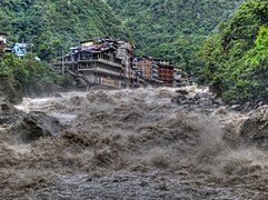
The Urubamba River or Vilcamayo River is a river in Peru. Upstream it is called Vilcanota River. Within the La Convención Province, the name changes to Urubamba. A partially navigable headwater of the Amazon River, the Urubamba rises in the Andes to the southeast of Cusco. It originates on the slopes of Cunurana in the Puno Region, Melgar Province, near the La Raya pass. It flows north-north-west for 724 km (450 mi) before coalescing with the Tambo River to form the Ucayali River.
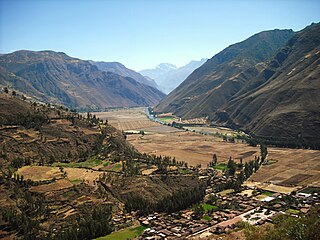
The Sacred Valley of the Incas, or the Urubamba Valley, is a valley in the Andes of Peru, north of the Inca capital of Cusco. It is located in the present-day Peruvian region of Cusco. In colonial documents it was referred to as the "Valley of Yucay." The Sacred Valley was incorporated slowly into the incipient Inca Empire during the period from 1000 to 1400.

Huayna Picchu, Quechua: Wayna Pikchu, is a mountain in Peru around which the Urubamba River bends. It is located in the Cusco Region, Urubamba Province, Machupicchu District. It rises over Machu Picchu, the so-called lost city of the Incas. The Incas built a trail up the side of the Huayna Picchu and built temples and terraces on its top. The peak of Huayna Picchu is 2,693 metres (8,835 ft) above sea level, or about 260 metres (850 ft) higher than Machu Picchu.

PeruRail is a railway operator providing tourist, freight, and charter services in southern Peru. It was founded in 1999 by two Peruvian entrepreneurs and the British company Sea Containers.

Urubamba Province is one of thirteen provinces in the Cusco Region in the southern highlands of Peru.

The Lares trek is a two- or three-day high-altitude hike in Cusco, Peru, starting near the village Lares, approximately 40 mi (64 km) north of Cusco and 35 mi (56 km) east of Machu Picchu. The Lares Valley lies in the east of the Urubamba mountain range, traversing part of the Sacred Valley. Reaching the start of the trek requires a bus or van trip of approximately five hours from the village of Lares. The trek route transverses typical Peruvian Andean mountain areas.

Putucusi is a round-shaped mountain located on the opposite side (northeast) of the Urubamba River to Machu Picchu in the Cusco Region of Peru. Reaching approximately 2,560 metres (8,400 ft) above sea level at its peak, the mountain offers epic views of Machu Picchu and the surrounding Urubamba River valley.

Machupicchu is one of seven districts of the Urubamba Province in Peru. The village of Machupicchu is the seat or capital of the district.

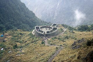
Inti Punku or Intipunku is an archaeological site in the Cusco Region of Peru that was once a fortress of the sacred city, Machu Picchu. It is now also the name of the final section of the Incan Trail between the Sun Gate complex and the city of Machu Picchu. It was believed that the steps were a control gate for those who enter and exited the Sanctuary.
Cusichaca River, is a river in Peru located in the Cusco Region, Urubamba Province, on the border of the districts Machupicchu and Ollantaytambo. Its waters flow to the Vilcanota River.

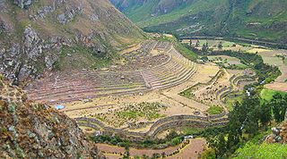
Patallacta, Llactapata or Q'ente Marka is an archaeological site in Peru located in the Cusco Region, Urubamba Province, Machupicchu District. It is situated southeast of the site Machu Picchu, at the confluence of the rivers Cusichaca and Vilcanota on a mountain named Patallacta.

Intihuatana at the archaeological site of Machu Picchu is a notable ritual stone associated with the astronomic clock or calendar of the Inca in South America. Machu Picchu was thought to have been built c. 1450 by the Sapa Inca Pachacuti as a country estate. In the late 16th century, the Viceroy Francisco de Toledo and the clergy destroyed those Intihuatana which they could find. They did so as they believed that the Incas' religion was a blasphemy and the religious significance of the Intihuatana could be a political liability. The Intihuatana of Machu Picchu was found intact by Bingham in 1911, indicating that the Spanish conquerors had not found it. Intihuatana was damaged on September 8, 2000 when a crane being used in an ad shoot toppled over and chipped off a piece of the granite.

Intihuatana is a ritual stone in South America associated with the astronomic clock or calendar of the Inca. Its name is derived from the local Quechua language. The most notable Intihuantana is an archaeological site located at Machu Picchu in the Sacred Valley near Machu Picchu, Peru. The name of the stone is derived from Quechua: inti means "sun", and wata- is the verb root "to tie, hitch (up)". The Quechua -na suffix derives nouns for tools or places. Hence inti watana is literally an instrument or place to "tie up the sun", often expressed in English as "The Hitching Post of the Sun".
Runkuraqay or Runku Raqay is an archaeological site on a mountain of the same name in Peru located in the Cusco Region, Urubamba Province, Machupicchu District. It is situated southeast of the archaeological site Machu Picchu and south of the Vilcanota river. The ruins lie on the southern slope of the mountain Runkuraqay near the Runkuraqay pass, northeast of the archaeological site Sayacmarca and southeast of the site Qunchamarka.

Qunchamarka is an archaeological site in Peru located in the Cusco Region, Urubamba Province, Machupicchu District, southwest of the mountain Runkuraqay. It lies between the archaeological sites Sayaqmarka and Phuyupatamarka on the Inca Trail to Machu Picchu.
Curcurorjo is a mountain in the Andes of Peru, about 4,400 m (14,400 ft) high. It is located in the Cusco Region, La Convención Province, Huayopata District, and in the Urubamba Province, Machupicchu District. Curcurorjo lies in the northwestern extensions of the Urubamba mountain range, northeast of the archaeological site of Machu Picchu.
Tunquiorjo is a mountain in the Andes of Peru, about 4,200 m (13,800 ft) high. It is located in the Cusco Region, La Convención Province, Huayopata District, and in the Urubamba Province, Machupicchu District. Tunquiorjo lies in the northwestern extensions of the Urubamba mountain range, northeast of the archaeological site of Machu Picchu.

Agustín Lizárraga Ruiz was a Peruvian explorer and farmer who discovered Machu Picchu on July 14, 1902, nine years prior to American explorer Hiram Bingham.