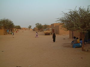
Kidal is a town and commune in the desert region of northern Mali. The town lies 285 km (177 mi) northeast of Gao and is the capital of the Kidal Cercle and the Kidal Region. The commune has an area of about 9,910 km2 (3,830 sq mi) and includes the town of Kidal and 31 other settlements.

Bandiagara is a small town and urban commune in the Mopti Region of Mali. The name translates roughly to "large eating bowl"—referring to the communal bowl meals are served in. Mainly on its Bandiagara Escarpment it has about 2,000 speakers of the vibrant Bangime language, an isolate used mainly as an anti-language; it has the highest point of the country.
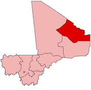
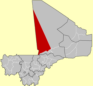
Kidal Region the eighth administrative region of Mali, covering 151,450 square kilometres or 58,480 square miles. This area was formerly part of Gao Region, but was created as a separate region in 1991. It is located in the north of the country, within the territory which the National Movement for the Liberation of Azawad proclaimed to be the independent nation-state of Azawad on 6 April 2012. This independence has not been recognized by any country or international organization. It was under the control of different armed movements such as the Ansar Dine and MNLA until January 2013, when French forces liberated the region. The Region's administrative capital is the town of Kidal.

Sokolo is a small town and rural commune in the Cercle of Niona in the Ségou Region of southern-central Mali. The commune has an area of approximately 2,219 square kilometers and includes the town and 17 villages. In the 2009 census the population was 23,338. The town lies 56 km north or Niono.
Tin-Essako is a rural commune and village, in the Tin-Essako Cercle in Mali's north-eastern Kidal Region. The village lies 115 km due east of Kidal. In the 2009 census the commune had a total population of 2,595.

Bamba is a small town and rural commune in the Bourem Cercle of the Gao Region of Mali. The town is located on the left (north) bank of the Niger River, 190 km east of Timbuktu and 230 km northwest of the town of Gao. In the 2009 census the commune had a population of 28,524.
Tinzaouaten is a Saharan rural commune in the far northeast of Mali on the Algerian border. The commune is in the Abeïbara Cercle of the Kidal Region. It included a stop on a trans-Saharan trade route and a military post on the frontier under the French colonial regime. In 2009 the 8,000 square kilometer commune had a population of 2,300, most of whom are nomadic Tuareg. The Algerian settlement of Tinzaouten is on the Algerian side of the border.

Douentza is a town and urban commune in the Mopti Region of central Mali. The town lies 145 km east-northeast of Mopti on the RN16, a paved road that links Mopti and Gao. It is the administrative center of the Douentza Cercle.
Goundam Circle is a second-level administrative subdivision of the Tombouctou Region in northern Mali. Its administrative center is the town of Goundam, although the most populous commune is that of Tonka. In the 2009 census, the circle had a population of 150,150.

Gao Cercle is an administrative subdivision of the Gao Region of north-eastern Mali. The administrative center (chef-lieu) is the town of Gao.

Tessalit Cercle is an administrative subdivision of the Kidal Region of Mali. The administrative centre is the village of Tessalit. The cercle is divided into communes, and below this, quarters/villages. As of 2009 the cercle had a population of 16,289.
Abeïbara is a small Saharan village and rural commune in the Abeïbara Cercle of the Kidal Region of north-eastern Mali. The commune has an area of approximately 8,320 square kilometers and contains 11 settlements. In the 2009 census it had a population of 4,585.
Kambila is a village and rural commune in the Cercle of Kati in the Koulikoro Region of south-western Mali. The commune has an area of 429 km2 and contains 15 villages. In the 2009 census the commune had a population of 13,974. The village of Kambila lies just to the east of the Route Nationale 1 (RN1) and 9 km north of Kati, the chef-lieu of the cercle.
Diédougou is a rural commune in the Cercle of Dioïla in the Koulikoro Region of south-western Mali. The commune contains 34 villages. The administrative center (chef-lieu) is at the village of Béléko Soba which lies 205 km east of Bamako. In the 2009 census the commune had a population of 39,021.
Koumbia is a village and commune in the Cercle of Yorosso in the Sikasso Region of southern Mali. The commune covers an area of 719 square kilometers and includes 11 villages. In the 2009 census it had a population of 24,915. The village of Koumbia, the administrative center (chef-lieu) of the commune, is 28 km north-northeast of Yorosso.
Songoua is a commune in the Cercle of Koutiala in the Sikasso Region of southern Mali. The commune covers an area of 107 square kilometers and includes the villages of Sirakélé and Kilé. In the 2009 census it had a population of 6,918. The village of Sirakélé, the administrative centre (chef-lieu) of the commune, is 15 km north of Koutiala.
Boghassa is a Saharan village and commune in the Cercle of Abeïbara in the Kidal Region of north-eastern Mali near the border with Algeria. In the 2009 census the commune had a population of 3,401.
Timtaghène is a rural commune in the Cercle of Tessalit in the Kidal Region of north-eastern Mali. The main village (chef-lieu) of the commune is Inabag which is 212 km (132 mi) due west of Aguelhok, 242 km (150 mi) southwest of Tessalit and 357 km (222 mi) northeast of Timbuktu. In the census of 2009 the commune had a population of 2,470. The commune is entirely desert and covers an area of approximately 30,000 km2, but it includes the settlements of Alybadine, Darassal, Tadjoudjoult, Tachrak, Tawhoutène, Tin Kar (Timétrine) and Teghaw-Ghawen.
Diabaly is a small town and rural commune in the Cercle of Niono in the Ségou Region of Mali. The commune has an area of approximately 1,538 square kilometres (594 sq mi) and includes 28 villages as well as the town. In the 2009 census the commune had a population of 35,266. The town lies 50 kilometres (31 mi) north of Niono on the west side of the Fala de Molodo channel that forms part of the Office du Niger irrigation scheme. The fields around the town are irrigated but much of the commune lies to the east of the Fala de Molodo in an area that lacks irrigation.
Konna is a town and rural commune in the Cercle of Mopti in the Mopti Region of Mali. The town lies 60 km northeast of Mopti on the eastern edge of the flood plain of the Niger River. The main RN16 highway linking Sévaré and Gao branches to the east just to the south of the town. The commune has an area of approximately 838 km2 and contains the town and 24 of the surrounding villages. In the 2009 census it had a population of 36,767.