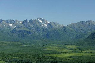
The Ahklun Mountains have many lakes, some more than 1,300 feet (400m) deep.[3] The mountains cover approximately 80 percent of the Togiak National Wildlife Refuge. The refuge also contains tundra and coastal plains.[4]
Environment
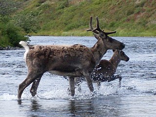
The Ahklun Mountains are dominated by alpine tundra, heath, and barrens, while moist sedge-tussock meadows occur in valley bottoms. Black spruce forest occurs on some hills and ridges. Forests of white spruce, paper birch, and alder cover the low hills along the major rivers.[5]Blackpoll warblers are common breeders in conifer stands in river valleys. Beaver are abundant, supporting a large annual harvest. Sockeye salmon are the most abundant fish. Chum, king, silver salmon, and rainbow trout are also numerous.[5] The average annual precipitation ranges from 19 to 25 inches (480 to 640mm), while the average annual temperature ranges from 29 to 33°F (−2 to 1°C). The growing season extends approximately from May 15 to September 10.[5]
The glaciers were first mapped by the U.S. Geological Survey, who used photogrammetry methods based on a 1972 series of aerial photos, revealing the presence of 116 glaciers. In 2006, 109 of these glaciers were resurveyed with the existence of 97 verified and 12 thought to have disappeared. This showed that over just three decades there had been a large decrease in the amount of land area covered by glacial ice in these mountains. The scientific community has long recognized the importance of glaciers as indicators of climatic change.[2]
In 2015, researchers analyzed aerial and satellite images from 1957, 1984, and 2009. They found that 10 out of 109 of the glaciers of the Ahklun Mountains originally mapped by the U.S Geological Survey in the 1970s had completely disappeared.[6] They also compared the size of the glaciers using aerial photographs and satellite images and found that the glaciers had lost about 50 percent of their total area.[6] At this rate of melting, they predict that all of the glaciers in the Ahklun Mountains will be gone by the end of this century.[6]
Geological evidence show that during the Pleistocene era there were repeated glaciations that have carved out a large number of valley troughs. On the eastern side, these troughs contain networks of glacial lakes, some that are over 1,300 feet (400m) deep and are dammed by terminal moraines.[3] On the southern and western side, the valleys are broader and are interspersed with rolling uplands pierced by rugged massifs.[3]
Lowlands
In the lowlands, areas not reached by the glaciation, the principal geographic features are the moraines and ridges formed by thrusting ice.[3]
A glacier is a persistent body of dense ice that is constantly moving under its own weight. A glacier forms where the accumulation of snow exceeds its ablation over many years, often centuries. Glaciers slowly deform and flow under stresses induced by their weight, creating crevasses, seracs, and other distinguishing features. They also abrade rock and debris from their substrate to create landforms such as cirques, moraines, or fjords. Glaciers form only on land and are distinct from the much thinner sea ice and lake ice that forms on the surface of bodies of water.
The exposed geology of the Yosemite area includes primarily granitic rocks with some older metamorphic rock. The first rocks were laid down in Precambrian times, when the area around Yosemite National Park was on the edge of a very young North American continent. The sediment that formed the area first settled in the waters of a shallow sea, and compressive forces from a subduction zone in the mid-Paleozoic fused the seabed rocks and sediments, appending them to the continent. Heat generated from the subduction created island arcs of volcanoes that were also thrust into the area of the park. In time, the igneous and sedimentary rocks of the area were later heavily metamorphosed.
The Wisconsin Glacial Episode, also called the Wisconsin glaciation, was the most recent glacial period of the North American ice sheet complex. This advance included the Cordilleran Ice Sheet, which nucleated in the northern North American Cordillera; the Innuitian ice sheet, which extended across the Canadian Arctic Archipelago; the Greenland ice sheet; and the massive Laurentide Ice Sheet, which covered the high latitudes of central and eastern North America. This advance was synchronous with global glaciation during the last glacial period, including the North American alpine glacier advance, known as the Pinedale glaciation. The Wisconsin glaciation extended from approximately 75,000 to 11,000 years ago, between the Sangamonian Stage and the current interglacial, the Holocene. The maximum ice extent occurred approximately 25,000–21,000 years ago during the last glacial maximum, also known as the Late Wisconsin in North America.
The Last Glacial Period (LGP), also known colloquially as the last ice age or simply ice age, occurred from the end of the Eemian to the end of the Younger Dryas, encompassing the period c. 115,000 – c. 11,700 years ago. The LGP is part of a larger sequence of glacial and interglacial periods known as the Quaternary glaciation which started around 2,588,000 years ago and is ongoing. The definition of the Quaternary as beginning 2.58 million years ago (Mya) is based on the formation of the Arctic ice cap. The Antarctic ice sheet began to form earlier, at about 34 Mya, in the mid-Cenozoic. The term Late Cenozoic Ice Age is used to include this early phase.
The Wallowa Mountains are a mountain range located in the Columbia Plateau of northeastern Oregon in the United States. The range runs approximately 40 miles (64 km) northwest to southeast in southwestern Wallowa County and eastern Union County between the Blue Mountains to the west and the Snake River to the east. The range is sometimes considered to be an eastern spur of the Blue Mountains, and it is known as the "Alps of Oregon". Much of the range is designated as the Eagle Cap Wilderness, part of the Wallowa–Whitman National Forest.
The Kuskokwim River or Kusko River is a river, 702 miles (1,130 km) long, in Southwest Alaska in the United States. It is the ninth largest river in the United States by average discharge volume at its mouth and seventeenth largest by basin drainage area. The Kuskokwim River is the longest river system contained entirely within a single U.S. state.
Glacial landforms are landforms created by the action of glaciers. Most of today's glacial landforms were created by the movement of large ice sheets during the Quaternary glaciations. Some areas, like Fennoscandia and the southern Andes, have extensive occurrences of glacial landforms; other areas, such as the Sahara, display rare and very old fossil glacial landforms.
Selawik National Wildlife Refuge in northwest Alaska in the Waring Mountains was officially established in 1980 with the passage of the Alaska National Interest Lands Conservation Act (ANILCA).
Bow Valley Provincial Park is a provincial park in Alberta, Canada. Established in 1959 in the arch of the Bow River at its confluence with the Kananaskis River, the park is one park of many within the Kananaskis Country park system.
The Sawtooth Wilderness is a federally-protected wilderness area that covers 217,088 acres (87,852 ha) of the state of Idaho. Managed by the U.S. Forest Service in the U.S. Department of Agriculture, it was designated the Sawtooth Primitive Area in 1937 to preserve the exceptional scenic beauty of the Sawtooth Mountains. On August 22, 1972 Public Law 92-400 designated the Primitive Area as the Sawtooth Wilderness and part of the newly created Sawtooth National Recreation Area. As part of the National Wilderness Preservation System, the Sawtooth Wilderness is an area where human development and use are restricted and people are to remain only visitors. According to the United States Environmental Protection Agency, the Sawtooth Wilderness has some of the clearest air in the lower 48 states.
Misty Fjords National Monument is a national monument and wilderness area administered by the U.S. Forest Service as part of the Tongass National Forest. Misty Fiords is about 40 miles (64 km) east of Ketchikan, Alaska, along the Inside Passage coast in extreme southeastern Alaska, comprising 2,294,343 acres (928,488 ha) of Tongass National Forest in Alaska's Panhandle. All but 151,832 acres (61,444 ha) are designated as wilderness.
Southwest Alaska is a region of the U.S. state of Alaska. The area is not exactly defined by any governmental administrative region(s); nor does it always have a clear geographic boundary.
The Kanektok River is a 75-mile (121 km) stream in southwestern Alaska in the United States. Beginning in the Ahklun Mountains at Kagati and Pegati lakes, it flows westward into Kuskokwim Bay on the Bering Sea at the city of Quinhagak. Almost all of the river's course lies within the Togiak National Wildlife Refuge. The Quinhagak Village Corporation owns the land bordering the lowermost 17 miles (27 km) of the river.
U-shaped valleys, also called trough valleys or glacial troughs, are formed by the process of glaciation. They are characteristic of mountain glaciation in particular. They have a characteristic U shape in cross-section, with steep, straight sides and a flat or rounded bottom. Glaciated valleys are formed when a glacier travels across and down a slope, carving the valley by the action of scouring. When the ice recedes or thaws, the valley remains, often littered with small boulders that were transported within the ice, called glacial till or glacial erratic.
The Sawtooth Range is a mountain range of the Rocky Mountains in central Idaho, United States, reaching a maximum elevation of 10,751 feet (3,277 m) at the summit of Thompson Peak. It encompasses an area of 678 square miles (1,756 km2) spanning parts of Custer, Boise, Blaine, and Elmore counties, and is bordered to the east by the Sawtooth Valley. Much of the mountain range is within the Sawtooth Wilderness, part of the Sawtooth National Recreation Area and Sawtooth National Forest.
Togiak Wilderness is a federally designated wilderness area in the Dillingham and Bethel Census Areas in the southwestern part of the U.S. state of Alaska. At 2,274,066 acres (920,282 ha), it occupies the northern half of the Togiak National Wildlife Refuge. It protects pristine rivers, lakes, and steep-sloped mountains, including the rugged Ahklun Mountains and Wood River Range, which are located partly within the wilderness. Parts of the Kanektok, Goodnews, and Togiak drainages are also located within the boundaries of the Togiak Wilderness.
Bonanza Peak is a tall peak in the North Cascades in the U.S. state of Washington and the Glacier Peak Wilderness of the Wenatchee National Forest. At 9,516 feet (2,900 m) in elevation, it is the highest point in Chelan County, and the highest non-volcanic peak in Washington and the Cascade Range as a whole. Bonanza Peak's prominence is 3,711 feet (1,131 m), making it the 26th most prominent peak in Washington. The nearest higher peak is Glacier Peak, 14.4 miles (23.2 km) to the southwest.
The Beringia upland tundra is a mountainous tundra ecoregion of North America, on the west coast of Alaska.
Tupshin Peak is an 8,320+ ft mountain summit located in the Glacier Peak Wilderness of the North Cascades in Washington state. The mountain is situated in Chelan County, on land managed by Wenatchee National Forest. Its nearest higher peak is Devore Peak, 1.55 mi (2.49 km) to the south-southwest, and Bonanza Peak lies 6.71 mi (10.80 km) to the southwest. Precipitation runoff from the peak drains to nearby Lake Chelan via tributaries of the Stehekin River. The mountain's name comes from Chinook jargon and means "needle".
Dip Top Peak is a 7,291-foot-elevation mountain summit located in the Alpine Lakes Wilderness in eastern King County of Washington state. It is part of the Cascade Range and is set on land managed by Mount Baker-Snoqualmie National Forest. The peak is situated 1.25 mi (2.01 km) north of Mount Daniel, and less than one mile south of Jade Lake. Precipitation runoff from the mountain drains into East Fork Foss River, which is a tributary of the Skykomish River. The summit saddle has two rock horns, of which the higher southwest peak is the true summit. The first ascent was made August 1950 by Bill and Gene Prater. In the early 1970s, brothers Gene and Bill Prater created the modern aluminum snowshoe known today, and sold them via Bill's "Sherpa Snowshoes" company, which proved very popular.
This page is based on this Wikipedia article Text is available under the CC BY-SA 4.0 license; additional terms may apply. Images, videos and audio are available under their respective licenses.