
The South Bay is a region of the Los Angeles metropolitan area, located in the southwest corner of Los Angeles County. The name stems from its geographic location stretching along the southern shore of Santa Monica Bay. The South Bay contains fifteen cities plus portions of the City of Los Angeles and unincorporated portions of the county. The area is bounded by the Pacific Ocean on the south and west and generally by the City of Los Angeles on the north and east.
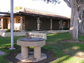
Los Alamitos is a city in Orange County, California. The city was incorporated in March 1960. The population was 11,780 at the 2020 census, up from 11,449 at the 2010 census. The adjacent unincorporated community of Rossmoor uses the same 90720 ZIP code in its mailing address, but is not part of the city. The Los Alamitos Race Course is named for the city, but lies in the neighboring city of Cypress.

Pacific Heights is a neighborhood in San Francisco, California. It has panoramic views of the Golden Gate Bridge, San Francisco Bay, the Palace of Fine Arts, Alcatraz, and the Presidio.

Area code 562 is a California telephone area code that was split from area code 310 on January 25, 1997. It is the area code for much of southeastern Los Angeles County, including Long Beach, and parts of northern Orange County.
The term Eastside or East Side has two different meanings in the city of Long Beach, California. The first, and more current meaning, refers to an area roughly comprising the eastern half of the city, usually excluding areas south of the east-west line made by Pacific Coast Highway/Atherton Street. This area is also called East Long Beach.

Bluff Park is a small, upscale neighborhood in Long Beach, California, United States. There is a bluff along much of the beach in Long Beach, and on one stretch, there is the narrow Bluff Park from which the neighborhood gets its name.

Belmont Shore is a neighborhood in Long Beach, California. It is home to many shops, restaurants, salons and business offices.

Naples is a neighborhood of Long Beach, California, United States, built on three islands located in Alamitos Bay. The islands are divided by canals which open into the bay. Most of the streets on the island have Italianate names. The center of Naples features a large fountain which serves as a popular meeting spot. The city was named after the Italian city Naples.

The El Dorado Park neighborhood of Long Beach, California, is on the east side of the city adjacent to the large El Dorado Regional Park. Lakewood is north of El Dorado Park, while Hawaiian Gardens is northeast, and Los Alamitos is east of El Dorado Park. The park is bounded on the east by the 605 Freeway, on the north by the Long Beach Towne Center shopping mall, and on the south by Stearns Street. Because of the barrier of the freeway and park between the neighborhood and the rest of Long Beach, as well as the barrier created by near Norwalk Blvd and the Coyote Creek and the neighboring cities, the El Dorado Park neighborhood feels quite separate.
The Long Beach Public Library (LBPL) is an American public library system located in Long Beach, California.
Bluff Heights is a neighborhood and historic district in Long Beach, California, composed mainly of Craftsman bungalows constructed from approximately 1910 to 1923.

The Long Beach Police Department provides law enforcement for the city of Long Beach, California.
Alamitos Beach is a coastal neighborhood in the southern portion of the city of Long Beach, California. Although it was in unincorporated Los Angeles County when annexed by the City of Long Beach, it had been planned as its own community with a townsite.
Carroll Park is a neighborhood in the city of Long Beach, California.
Hellman is a neighborhood in the city of Long Beach, California.
The 4th Street Corridor, also known as Retro Row, is a small business district in the city of Long Beach, California, along 4th Street from Walnut Avenue to Temple Avenue.

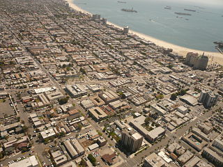
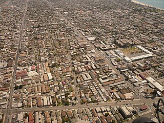
Long Beach, California, is composed of many different neighborhoods. Some neighborhoods are named after thoroughfares, while others are named for nearby parks, schools, or city features.
Belmont Park is a neighborhood in the city of Long Beach, California.
The Pacific Electric Railway established streetcar services in Long Beach in 1902. Unlike other cities where Pacific Electric operated local streetcars, Long Beach's system did not predate the company's services. Long Beach's network of streetcars peaked around 1911 with over 30 miles (48 km) of tracks throughout the city. Local services were discontinued in 1940, but interurban service to Los Angeles persisted until 1961. The route of the former main interurban line was rebuilt in the late 1980s as the Metro Blue Line, which operates at-grade with car traffic for a portion of its length.


