Mercury is the first planet from the Sun and the smallest in the Solar System. In English, it is named after the ancient Roman god Mercurius (Mercury), god of commerce and communication, and the messenger of the gods. Mercury is classified as a terrestrial planet, with roughly the same surface gravity as Mars. The surface of Mercury is heavily cratered, as a result of countless impact events that have accumulated over billions of years. Its largest crater, Caloris Planitia, has a diameter of 1,550 km (960 mi) and one-third the diameter of the planet. Similarly to the Earth's Moon, Mercury's surface displays an expansive rupes system generated from thrust faults and bright ray systems formed by impact event remnants.
Planetary nomenclature, like terrestrial nomenclature, is a system of uniquely identifying features on the surface of a planet or natural satellite so that the features can be easily located, described, and discussed. Since the invention of the telescope, astronomers have given names to the surface features they have discerned, especially on the Moon and Mars. To found an authority on planetary nomenclature, the International Astronomical Union (IAU) was organized in 1919 to designate and standardize names for features on Solar System bodies.
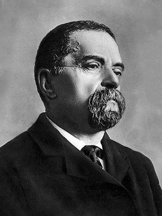
Giovanni Virginio Schiaparelli was an Italian astronomer and science historian.

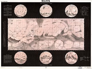
Areography, also known as the geography of Mars, is a subfield of planetary science that entails the delineation and characterization of regions on Mars. Areography is mainly focused on what is called physical geography on Earth; that is the distribution of physical features across Mars and their cartographic representations. In April 2023, The New York Times reported an updated global map of Mars based on images from the Hope spacecraft. A related, but much more detailed, global Mars map was released by NASA on 16 April 2023.
During the late 19th and early 20th centuries, it was erroneously believed that there were "canals" on the planet Mars. These were a network of long straight lines in the equatorial regions from 60° north to 60° south latitude on Mars, observed by astronomers using early telescopes without photography.

Eugène Michel Antoniadi was a Greek-French astronomer.

Hellas Planitia is a plain located within the huge, roughly circular impact basin Hellas located in the southern hemisphere of the planet Mars. Hellas is the third- or fourth-largest known impact crater in the Solar System. The basin floor is about 7,152 m (23,465 ft) deep, 3,000 m (9,800 ft) deeper than the Moon's South Pole-Aitken basin, and extends about 2,300 km (1,400 mi) east to west. It is centered at 42.4°S 70.5°E. Hellas Planitia spans the boundary between the Hellas quadrangle and the Noachis quadrangle.

The two moons of Mars are Phobos and Deimos. They are irregular in shape. Both were discovered by American astronomer Asaph Hall in August 1877 and are named after the Greek mythological twin characters Phobos and Deimos who accompanied their father Ares into battle. Ares, the god of war, was known to the Romans as Mars.

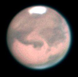
The classical albedo features of Mars are the light and dark features that can be seen on the planet Mars through an Earth-based telescope. Before the age of space probes, several astronomers created maps of Mars on which they gave names to the features they could see. The most popular system of nomenclature was devised by Giovanni Schiaparelli, who used names from classical antiquity. Today, the improved understanding of Mars enabled by space probes has rendered many of the classical names obsolete for the purposes of cartography; however, some of the old names are still used to describe geographical features on the planet.

Discovery and exploration of the Solar System is observation, visitation, and increase in knowledge and understanding of Earth's "cosmic neighborhood". This includes the Sun, Earth and the Moon, the major planets Mercury, Venus, Mars, Jupiter, Saturn, Uranus, and Neptune, their satellites, as well as smaller bodies including comets, asteroids, and dust.

The history of Mars observation is about the recorded history of observation of the planet Mars. Some of the early records of Mars' observation date back to the era of the ancient Egyptian astronomers in the 2nd millennium BCE. Chinese records about the motions of Mars appeared before the founding of the Zhou dynasty. Detailed observations of the position of Mars were made by Babylonian astronomers who developed arithmetic techniques to predict the future position of the planet. The ancient Greek philosophers and Hellenistic astronomers developed a geocentric model to explain the planet's motions. Measurements of Mars' angular diameter can be found in ancient Greek and Indian texts. In the 16th century, Nicolaus Copernicus proposed a heliocentric model for the Solar System in which the planets follow circular orbits about the Sun. This was revised by Johannes Kepler, yielding an elliptic orbit for Mars that more accurately fitted the observational data.

Hesperia Planum is a broad lava plain in the southern highlands of the planet Mars. The plain is notable for its moderate number of impact craters and abundant wrinkle ridges. It is also the location of the ancient volcano Tyrrhena Mons. The Hesperian time period on Mars is named after Hesperia Planum.

Planetary science is the scientific study of planets, celestial bodies and planetary systems and the processes of their formation. It studies objects ranging in size from micrometeoroids to gas giants, aiming to determine their composition, dynamics, formation, interrelations and history. It is a strongly interdisciplinary field, which originally grew from astronomy and Earth science, and now incorporates many disciplines, including planetary geology, cosmochemistry, atmospheric science, physics, oceanography, hydrology, theoretical planetary science, glaciology, and exoplanetology. Allied disciplines include space physics, when concerned with the effects of the Sun on the bodies of the Solar System, and astrobiology.

Mons is a mountain on a celestial body. The term is used in planetary nomenclature: it is a part of the international names of such features. It is capitalized and usually stands after the proper given name, but stands before it in the case of lunar mountains.

Collis is a small hill or knob on a celestial body. The term is used in planetary nomenclature: it is a part of international proper names of such features. Like other generic terms, it is capitalized and stands after the proper name. As of 2015, only groups of the hills have names, and the term is used only in plural.

Schiaparelli EDM was a failed Entry, Descent, and Landing Demonstrator Module (EDM) of the ExoMars programme—a joint mission of the European Space Agency (ESA) and the Russian Space Agency Roscosmos. It was built in Italy and was intended to test technology for future soft landings on the surface of Mars. It also had a limited but focused science payload that would have measured atmospheric electricity on Mars and local meteorological conditions.

PateraPAT-ər-ə is an irregular crater, or a complex crater with scalloped edges on a celestial body. Paterae can have any origin, although the majority of them were created by volcanism. The term comes from Latin, where it refers to a shallow bowl used in antique cultures.
The following outline is provided as an overview of and topical guide to Mars: