
Segesta was one of the major cities of the Elymians, one of the three indigenous peoples of Sicily. The other major cities of the Elymians were Eryx and Entella. It is located in the northwestern part of Sicily in Italy, near the modern commune of Calatafimi-Segesta in the province of Trapani. The hellenization of Segesta happened very early and had a profound effect on its people.

The Don is the fifth-longest river in Europe. Flowing from Central Russia to the Sea of Azov in Southern Russia, it is one of Russia's largest rivers and played an important role for traders from the Byzantine Empire.
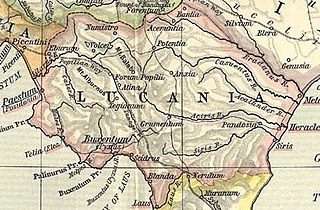
Lucania was a historical region of Southern Italy. It was the land of the Lucani, an Oscan people. It extended from the Tyrrhenian Sea to the Gulf of Taranto.
Casal Velino, also spelled Casalvelino, is a town and comune in the province of Salerno in the Campania region of south-western Italy.
Casaletto Spartano is a town and comune in the province of Salerno in the Campania region of south-western Italy.

Castelnuovo Cilento is a town and comune in the province of Salerno in the Campania region of south-western Italy.

Prignano Cilento is a town and comune in the province of Salerno in the Campania region of south-western Italy. As of 2017 its population was of 1,035.

Heraclea, also Heracleia or Herakleia, was an ancient city of Magna Graecia. It was situated on the Gulf of Taranto between the rivers Aciris and Siris. The ruins of the city are located in the modern comune of Policoro in the Province of Matera, Basilicata, Italy.
Laüs or Laus was an ancient city of Magna Graecia on the coast of the Tyrrhenian Sea. It was a colony of Sybaris at the mouth of the Lao River, which formed the boundary between Lucania and Bruttium in ancient times. The river and the city have the same name in Ancient Greek. Today the archaeological site of the city can be found at a short distance to the east of Marcellina, a frazione of the comune of Santa Maria del Cedro in Calabria.

Santa Barbara is an Italian village and hamlet (frazione) of the commune of Ceraso in the Province of Salerno, Campania. It has a population of roughly a thousand.
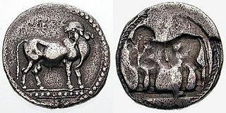
Sybaris on the Traeis was an ancient city of Magna Grecia situated on the Traeis river, now known as the Trionto. It shares its name with the original city of Sybaris which was destroyed in 510 BC. Its former inhabitants built a new city, Thurii, not far from the site of Sybaris. This new colony was founded together with other Greek settlers in 446/445 BC. Soon a conflict arose between the two groups and most of the Sybarites were killed by the other Greek colonists of Thurii. The Sybarites who managed to flee then founded Sybaris on the Traeis a short time after 444 BC. The city was destroyed by the Bruttii not long after their emergence as an ethnic group in 356/355 BC.
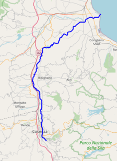
The Crati is a river in Calabria, southern Italy. It is the largest river of Calabria and the third largest river of southern Italy after the Volturno and the Sele. In classical antiquity it was known as the Crathis or Crater.
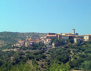
Cilento is an Italian geographical region of Campania in the central and southern part of the Province of Salerno and an important tourist area of southern Italy.

Pruno is a forest in the Campania region of southern Italy. It is the largest woodlands of central Cilento region. The hamlets (frazioni) with this name are situated in the municipalities of Laurino, Valle dell'Angelo and Piaggine, and are considered a singular village.

Cilento, Vallo di Diano and Alburni National Park is an Italian national park in the Province of Salerno, in Campania in southern Italy. It includes much of the Cilento, the Vallo di Diano and the Monti Alburni. It was founded in 1991, and was formerly known as the Parco Nazionale del Cilento e Vallo di Diano.
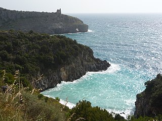
The Cilento Coast is an Italian stretch of coastline of Cilento, on the southern side of the Province of Salerno. It is situated in the gulfs of Salerno and Policastro, extending from the municipalities of Capaccio-Paestum in the north-west, to Sapri in the south-east.

Magliano Nuovo is a southern Italian village and hamlet (frazione) of Magliano Vetere, a municipality in the province of Salerno, Campania. As of 2011, its population was 334.

Marina di Casalvelino, also spelled Casalvelino Marina, is a southern Italian village and hamlet (frazione) of Casal Velino, a municipality in the province of Salerno, Campania. With a population of 1,263 (2009), it is the most populated hamlet of its municipality.

Piano Vetrale, also shortened as Vetrale or Piano, is a southern Italian village and hamlet (frazione) of Orria, a municipality in the province of Salerno, Campania. As of 2011, its population was of 475.
The Bussento is a river in southwestern Italy. Originating from Cervati mountain, it flows in the Campanian territory of Cilento, in the Province of Salerno. Its mouth is by the Tyrrhenian Sea, nearby Policastro Bussentino.

