Britannia Beach is a small unincorporated community in the Squamish-Lillooet Regional District located approximately 55 kilometres north of Vancouver, British Columbia on the Sea-to-Sky Highway on Howe Sound. It has a population of about 300. It includes the nearby Britannia Creek, a small to mid-sized stream that flows into Howe Sound that was historically one of North America's most polluted waterways.
Cassiar is a ghost town in British Columbia, Canada. It was a small company-owned asbestos mining town located in the Cassiar Mountains of Northern British Columbia north of Dease Lake.
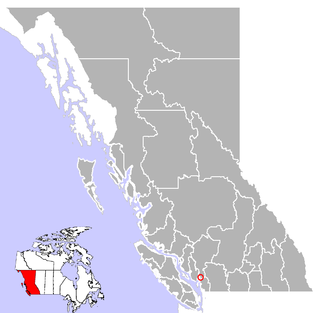
Princeton is a town municipality in the Similkameen area of southern British Columbia, Canada. The former mining and railway hub lies at the confluence of the Tulameen into the Similkameen River, just east of the Cascade Mountains. It is at the junction of BC Highway 3 and 5A.
Anyox was a small company-owned mining town in British Columbia, Canada. Today it is a ghost town, abandoned and largely destroyed. It is located on the shores of Granby Bay in coastal Observatory Inlet, about 60 kilometres southeast of Stewart, British Columbia, and about 20 kilometres, across wilderness east of the tip of the Alaska Panhandle.
Hedley is an unincorporated community near the mouth of Hedley Creek in the Similkameen region of southern British Columbia. The former mining town, on BC Highway 3, is by road about 74 kilometres (46 mi) southwest of Penticton and 38 kilometres (24 mi) southeast of Princeton.

The Bulkley Valley is in the northwest Central Interior of British Columbia, Canada.

Strathcona-Westmin Provincial Park is a Class B provincial park located at the southern extremity of Buttle Lake on Vancouver Island in British Columbia, Canada. The park was separated out from Strathcona Provincial Park by BC Parks in 1987 so that mining operations could proceed within park boundaries. Strathcona-Westmin is expected to be reabsorbed into Strathcona Provincial Park once mining operations cease.
Mount Sicker is in southern Vancouver Island, British Columbia. The twin summits of Big Sicker Mountain, at 716 metres (2,349 ft), and Little Sicker Mountain, at 660 metres (2,170 ft), are near Crofton, Chemainus and Duncan.
Robert Allan Brown was a well-known and flamboyant prospector and speculator in 19th and early 20th Century in the Canadian province of British Columbia. He was known generally as Volcanic Brown, especially in the province's Kootenay and Boundary districts and in adjoining Eastern Washington, and also as Sunset Brown in the Similkameen District and still also to others as Crazy Brown. His enthusiastic nature contributed to his nickname, and as result of that and his flamboyant personality he was a fixture in mining industry news in a wide region which spanned the British Columbia-United States border.
The Similkameen Gold Rush, also known as the Blackfoot Gold Rush, was a minor gold rush in the Similkameen Country of the Southern Interior of British Columbia, Canada, in 1860. The Similkameen Rush was one of a flurry of small rushes peripheral to the Fraser Canyon Gold Rush, which had drawn tens of thousands of prospectors to the new colony in 1858-1859, among the others being Rock Creek Gold Rush and Big Bend.
The Similkameen Country, also referred to as the Similkameen Valley or Similkameen District, but generally referred to simply as The Similkameen or more archaically, Similkameen, is a region roughly coinciding with the basin of the river of the same name in the Southern Interior of British Columbia. The term "Similkameen District" also refers to the Similkameen Mining District, a defunct government administrative district, which geographically encompasses the same area, and in more casual terms may also refer to the Similkameen electoral district, which was combined with the Grand Forks-Greenwood riding by the time of the 1966 election. The Similkameen Country has deep historical connections to the Boundary Country and the two are sometimes considered one region, partly as a result of the name of the electoral district. It is also sometimes classed as being part of the Okanagan region, which results from shared regional district and other administrative boundaries and names. The term "Similkameen District" may also historically refer to the Similkameen Division Yale Land District, which also includes Osoyoos and the Boundary Country to Osoyoos' east.
Copper Mountain was an important copper-mining company town in the Similkameen Country of the Southern Interior of British Columbia, Canada, just south of the town of Princeton.

Phoenix is a ghost town in the Boundary Country of British Columbia, Canada, 11 km east of Greenwood. Once called the "highest city in Canada" by its citizens it was a booming copper mining community from the late 1890s until 1919. In its heyday it was home to 1,000 citizens and had an opera house, twenty hotels, a brewery and its own city hall. Phoenix's magistrate, Judge Willie Williams, who served there from 1897 until 1913, became famous for his booming declaration, "I am the highest judge, in the highest court, in the highest city in Canada." In 1911, Phoenix's hockey team won the provincial championship and asked for the right to compete for the Stanley Cup, but it was too late to qualify. The Granby Consolidated Mining, Smelting and Power Company operated the Phoenix Mine, a copper mine that produced 13,678,901 tons of ore before operations ceased on June 14, 1919.

Rock Creek is a settlement in the Boundary Country region of south central British Columbia. The unincorporated settlement is mostly on the southwest side of the Kettle River at the confluence with Rock Creek. The place lies at the junction of BC Highway 33, and BC Highway 3.

The Ashnola River is a tributary of the Similkameen River, rising in the northeastern part of the North Cascades in Washington, United States, and flowing north into British Columbia, Canada, to join the Similkameen River about halfway along that river's course between the towns of Princeton and Keremeos. The river crosses the international boundary at 49°00′00″N120°19′37″W and transits Cathedral Provincial Park. It has one main tributary, Ewart Creek, which is about 25 kilometres (16 mi) long and begins virtually at the border and is entirely within Cathedral Park.
Granby Consolidated Mining, Smelting and Power Co. was established by charter to operate in the Boundary region of southern British Columbia. Primarily involved in the mining and smelting of copper, the conglomerate became a publicly traded company. The various corporate operating names within the former group mostly specified the Granby identity.
Corbin is a ghost town in British Columbia, Canada. It was a coal mining community located at the foot of Coal Mountain, south of the Crowsnest Pass in the southern Canadian Rockies.

The Highland Valley Copper mine is the largest open-pit copper mine in Canada, located near Logan Lake, British Columbia. It is an amalgamation of three historic mining operations: Bethlehem, Lornex and Highmont.

The Mount Polley mine is a Canadian gold and copper mine located in British Columbia near the towns of Williams Lake, and Likely. It consists of two open-pit sites with an underground mining component and is owned and operated by the Mount Polley Mining Corporation, a wholly owned subsidiary of Imperial Metals. In 2013, the mine produced an output of 38,501,165 pounds (17,463,835 kg) of copper, 45,823 ounces of gold, and 123,999 of silver. The mill commenced operations in 1997 and was closed and placed on care and maintenance in 2019. The company owns 20,113 hectares (201.13 km2) of property near Quesnel Lake and Polley Lake where it has mining leases and operations on 2,007 hectares (20.07 km2) and mineral claims on 18,106 hectares (181.06 km2). Mineral concentrate is delivered by truck to the Port of Vancouver.
