Arriving in 1860 during the Similkameen Gold Rush, John Fall Allisonpre-empted65 hectares (160 acres) of farmland immediately northeast of the river fork.[3] The Marston family, who had pre-empted the present townsite, left in 1871.[4] About 4 kilometres (2.5mi) downstream from the fork, the settlement of Prince Town was laid out on the hillside, but was soon abandoned.[5] The name honoured the Prince of Wales, the future Edward VII, who made a royal visit to Eastern Canada in 1860. The revised spelling as Princeton was quickly adopted for settlement in the general area.[6]
During 1860–1870, Princeton was the administrative centre for the Similkameen District.[7] In 1868, John's second marriage was to Susan Louisa Moir.[8][9] In the 1870s, the fork was a cattle centre from which herds were driven over the mountain trail to Hope.[10] In 1888, John became the inaugural postmaster.[11] In 1897, he died.[12]
In the 1880s, Ah Tuck ran a log cabin Chinese boarding house. In 1897, James Wallace opened[13] the large two-storey hotel called Wallace House, which fire destroyed in 1911.[14] In 1899, John Henry Jackson completed the two-and-a-half-storey log hotel called Jackson House. On selling and enlarging in 1906, it was renamed the Great Northern Hotel but burned down in 1912.[15]
By 1900, the town included a restaurant, two hotels, two livery stables, two butcher shops, two blacksmith shops, two laundries, three sawmills, and government buildings.[16] That year, a newspaper was launched, and the Allison townsite was laid out in the vicinity of the earlier Prince Town[17] (now encompassed by the Weyerhaeuser sawmill property). In partnership with Edgar Dewdney, the Allison family in due course promoted a rival townsite called Norman about 8 kilometres (5mi) farther downriver. This venture proved unprofitable.[12]
The three-storey, 20-room Tulameen Hotel was completed in 1902, but burned to the ground in 1904. The rebuild was in 1906[14] and demolition in 1960.[15] The Similkameen Hotel was built in 1911 but burned down in 1930.[18] Fires at the 40-room Princeton Hotel, which opened in 1912,[19] caused severe damage in 1930[20] and complete destruction in 2006.[21]
Princeton was incorporated as a village municipality in 1951 and as a town municipality in 1978.[22]
In the 1980s, a downtown revitalization began, which included red brick sidewalks and new streetlights. In the 1990s, Princeton adopted a "heritage" theme, with many businesses converting their exteriors to match architectural styles from a century earlier.[23]
Industry
The British Columbia Copper Mining Co was formed in 1883 to acquire the mineral claims on Copper Mountain.[24]
Castle ruins, Princeton, 2008
The town of Princeton relies heavily on the copper mining industry. The copper ore was originally found in 1883 and the first underground pit was opened in 1923 and continued running until 1957. Surface mining started at the mine back in 1979 and was later shut down in 1996. copper Mountain Mine Corporation bought the mine in 2006 and started running operations in 2011. The mine is still called Copper Mountain Mine however it is now owned by Hudbay Minerals. This mine has generated income and jobs for Princeton locals and has become a tourist attraction for people across North America due to it being one of the largest copper mines in Canada.
The Princeton Brewing Co, which was founded in 1902, closed after the 1961 sale to the Molson Brewery group.[26]
After investing $1 million in infrastructure, The British Columbia Portland Cement Company plant opened about 3 kilometres (2mi) northeast in 1913 but closed weeks later.[27] The ruins are part of the Rainbow Lake Castle Resort.[28]
In 1910, a community water supply system was established. The providers of town electricity were Princeton Coal and Land 1911–1914 and then the copper mining company from 1915, running a line from the defunct cement plant. In 1917, West Kootenay Power agreed to extend a line from Bonnington Falls dam. In 1922, the Princeton Light and Power Co became the distributor.[29]
Although forestry and mining have been the dominant industries since that time,[30] tourism and agriculture developed in the latter half of the century,[31] and pharmaceutical cannabis production emerged around 2020.[32]
Education and health
Princeton is part of School District 58 Nicola-Similkameen, and has two elementary schools (John Allison for grades K–3 and Vermilion Forks for grades 4–7), and Princeton Secondary School (for grades 8–12), which includes The Bridge (for adult learners who have not completed high school).[33]
Interior Health provides level 1 health care at the Princeton General Hospital. The 6-bed acute care unit is complemented by a 36-bed extended care unit (Ridgewood Lodge).[31]
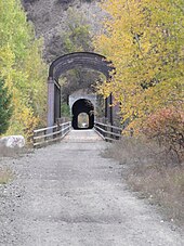
Eastward view of former railway bridge and tunnel, Princeton, 2010
The town also has a diabetes clinic, a mental health drop-in centre, and various counseling services to address needs such as balanced nutrition and substance abuse.[34]
Railways
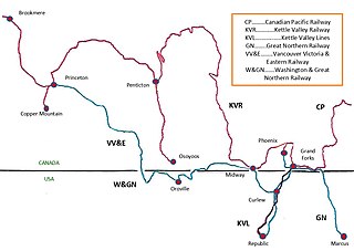
The Great Northern Railway (GN) owned the Vancouver, Victoria and Eastern Railway (VV&E). In November 1909, the northwestward advance of the VV&E rail head crossed the falsework of the Similkameen rail bridge and entered Princeton.[35] In July 1911, tracklaying continued westward through the tunnel excavated beneath Bromley Ridge.[36]
The Canadian Pacific Railway (CP) owned the Kettle Valley Railway (KV). In April 1915, the westward extension of the KV rail head crossed the Tulameen River and joined the GN track in Princeton.[37]
In October 1920, the CP branch from Princeton to Copper Mountain was completed.[38]
When the GN bridge washed out in April 1934, GN service into Princeton ended permanently.[62]
When the mine ceased operating in 1957, the CP Copper Mountain branch closed and the track was lifted that summer.[63]
Passenger service ended in January 1964.[64] The final freight train passed through in May 1989 and by the end of the summer 1991 all track had been lifted.[65]
Prior to 1949, the main thoroughfare was via the Merritt area. A bridge over the Tulameen (originally called the North Fork of the Similkameen) was washed out during the 1870s. Subsequently, First Nations provided an informal canoe service, but users demanded a government bridge because the ferry charges were considered exorbitant.[68] In 1885, a two-truss-span bridge was erected.[69]
In May 1900, a ferry was installed across the Similkameen to facilitate bridge construction.[70] In March 1901, this Howe truss at the south end of Bridge St was completed,[71] but an ice floe damaged the middle pier and shattered the southern abutment of the Tulameen bridge.[72] At the time, C.O. French had been operating an aerial ferry over the Similkameen about 3 kilometres (2mi) upstream.[73] That August, the Tulameen bridge was completely rebuilt as a Howe truss.[74]
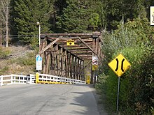
Brown Bridge, Princeton, 2008
In 1918, a two-span Howe truss was built alongside the Similkameen bridge,[75] and the former bridge was demolished the following year.[76]
Built in the 1930s, the replacement single-lane wooden Tulameen crossing is known as the Brown Bridge. In 2018, a semi-trailer caused structural damages to the bridge, one of many such incidents.[77]
The steel truss, which replaced the Similkameen bridge in 1948, was replaced by a concrete-decked span in 2003.[26][78]
In 1964, the present steel highway bridge over the Tulameen opened.[79][80]
In 2009, the award-winning Bridge of Dreams was built upon the substructure of the 1909 KV bridge.[81]
Road and air transport
Princeton Museum, 2008
By 1899, the stage journey from Spences Bridge took three and a half days.[29] Two operators provided a weekly stage on the route.[82]
In 1901, the Princeton–Hedley–Keremeos road was built, the initial section being the Old Hedley Rd.[83]
In 1920, a Merritt–Princeton auto stage commenced.[84] In 1928, the road to Merritt was upgraded to highway status.[85] Coalmont Road, which had formed the southern end, was replaced by the present section via Allison Lake.[86]
With the highway upon the abandoned VV&E right-of-way along the south bank superseding the Princeton-Stemwinder section of the Old Hedley Rd,[62] paving was tendered in May 1947 for the adjoining section southeastward.[87] In November 1949, the Hope–Princeton highway opened.[88]
By 1960, Greyhound had abandoned the Merritt–Princeton route. In September 1961, the replacement operator discontinued the run.[89]
In June 2018, Greyhound abandoned the Hope–Penticton route, which included Princeton.[90] The summer bus service between Kaslo and Vancouver, instituted by a regional operator in June 2019, routed through Princeton.[91] By 2023, the twice weekly service, which stopped in Princeton, had become year round.[92]
In 1987, Burt Reynolds starred in the film Malone, which was filmed mainly in neighbouring Hedley, but included key scenes in downtown Princeton and the surrounding area. Also partly shot in the area was Sean Penn's 2001 film The Pledge, starring Jack Nicholson, which was also filmed in Lytton and Lillooet.
The 2021 flood submerged half the town after the rivers overflowed their banks and dikes. Water levels were 150 centimetres (59in) higher than the 1995 flood.[103]
In the early 2020s, the downtown was again revitalized with the placement of bronze wildlife statues, sidewalk upgrades,[104] and visitor centre and RV campground enhancements, partially financed by a $750,000 federal government grant.[105]
Sunflower Downs, fairgrounds, Princeton, 2008
In 2023, 20 new temporary homes opened for seniors displaced by the 2021 flood.[106]
Culture and leisure
In addition to camping, fishing, hunting, and golf, popular activities include:
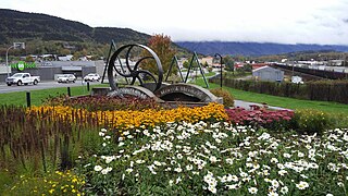
Bronze Sculpture Walk, which comprises wildlife sculptures along the main streets.
The Princeton and District Museum and Archives houses a fossil collection, First Nations artifacts, pioneer life exhibits, a 1900 stagecoach, and 1934 fire engine.
Biking or hiking the KVR or China Ridge trails in summer and cross country skiing and snow shoeing the trails during winter.[107]
Manning Park to the west offers a similar range of outdoor activities.[108]
Annual events include The Princeton Pro Rodeo, Family Day, and Canada Day celebrations.
Important facilities are the Centennial Pool, 700-seat hockey arena, curling rink, and 14 local parks.[31]
In the 2021 Census of Population conducted by Statistics Canada, Princeton had a population of 2,894 living in 1,377 of its 1,521 total private dwellings, a change of 2.3% from its 2016 population of 2,828. With a land area of 59.28km2 (22.89sqmi), it had a population density of 48.8/km2 (126.4/sqmi) in 2021.[120]
Ethnicity
Panethnic groups in the Town of Princeton (1986−2021)
Princeton has a continental climate (KöppenDfb) with semi-arid influences. It is located just east of the Cascade mountains, giving the town a rain shadow effect whereby the community receives very little precipitation relative to areas on the windward side of the Cascade mountains. Princeton is one of the sunniest places in British Columbia with 2,088 hours of sunshine annually. The 323 days per year with measurable sunshine, defined by having a minimum of 6 minutes of sunshine in a day,[132] is the most in the province, and one of the highest in Canada. The 29.4 days with measurable sunshine in March is the highest in the country.
Climate data for Princeton Aerodrome, 1981–2010 normals, extremes 1893–present.a
↑ "Hope Standard". www.newspapers.com. 9 Jul 1969. p.1. …Isabel Dawson, minister without portfolio…was no stranger to Hope and the Yale-Lillooet area, because she had lived in Princeton…
↑ "Princeton". Environment Canada. 31 Oct 2011. Retrieved 17 Feb 2017.
↑ "Princeton". Environment Canada. 31 Oct 2011. Retrieved 17 Feb 2017.
Notes
↑ Statistic includes all persons that did not make up part of a visible minority or an indigenous identity.
↑ Statistic includes total responses of "Filipino" and "Southeast Asian" under visible minority section on census.
↑ Statistic includes total responses of "Chinese", "Korean", and "Japanese" under visible minority section on census.
↑ Statistic includes total responses of "West Asian" and "Arab" under visible minority section on census.
↑ Statistic includes total responses of "Visible minority, n.i.e." and "Multiple visible minorities" under visible minority section on census.
Related Research Articles
Terrace is a city in the Skeena region of west central British Columbia, Canada. This regional hub lies east of the confluence of the Kitsumkalum River into the Skeena River. On BC Highway 16, junctions branch northward for the Nisga'a Highway to the west and southward for the Stewart–Cassiar Highway to the east. The locality is by road about 204 kilometres (127 mi) southwest of Smithers and 144 kilometres (89 mi) east of Prince Rupert. Transportation links are the Northwest Regional Airport, a passenger train, and bus services.
Merritt is a city in the Nicola Valley of the south-central Interior of British Columbia, Canada. It is 270 km (170 mi) northeast of Vancouver. Situated at the confluence of the Nicola and Coldwater rivers, it is the first major community encountered after travelling along Phase One of the Coquihalla Highway and acts as the gateway to all other major highways to the B.C. Interior. The city developed in 1893 when part of the ranches owned by William Voght, Jesus Garcia, and John Charters were surveyed for a town site.
Creston is a town in the Kootenay region of southeastern British Columbia, Canada.
Savona ( is an unincorporated community in the Thompson Country region of south central British Columbia. The place is on the western end and south shore of Kamloops Lake, adjacent to the outlet into the Thompson River. On BC Highway 1, the locality is by road about 38 kilometres east of Cache Creek and 45 kilometres west of Kamloops. The surrounding countryside is semi-arid grasslands and hills, which support cattle ranching.
Hedley is an unincorporated community near the mouth of Hedley Creek in the Similkameen region of southern British Columbia. The former mining town, on BC Highway 3, is by road about 74 kilometres (46 mi) southwest of Penticton and 38 kilometres (24 mi) southeast of Princeton.
Sicamous is a district municipality in the Shuswap Country region of south central British Columbia. The place is adjacent to the narrows, which is the confluence of Mara Lake into Shuswap Lake. At the BC Highway 97A intersection on BC Highway 1, the locality is by road about 73 kilometres (45 mi) west of Revelstoke, 140 kilometres (87 mi) east of Kamloops, and 75 kilometres (47 mi) north of Vernon.
Canal Flats is a village municipality in the East Kootenay region of southeastern British Columbia. This Columbia Valley community lies between the southern end of Columbia Lake and the northwest shore of the Kootenay River. The locality, on Highway 93/95, is by road about 83 kilometres (52 mi) north of Cranbrook and 165 kilometres (103 mi) southeast of Golden.
The Regional District of Okanagan-Similkameen (RDOS) is in southern British Columbia, adjacent to the U.S. state of Washington. It is bounded by Fraser Valley Regional District to the west, Thompson-Nicola Regional District and Regional District of Central Okanagan to the north, Regional District of Kootenay Boundary to the east, and by Okanogan County, Washington to the south. At the 2011 census the population was 80,742. The district covers a land area of 10,413.44 square kilometres (4,020.65 sq mi). The administrative offices are in the City of Penticton.
Ymir is a village in the Selkirk Mountains in the West Kootenay region of southeastern British Columbia. Ymir is located where the Salmo River meets Quartz Creek, and Ymir Creek. The locality, on BC Highway 6, is by road about 10 kilometres (6 mi) northeast of Salmo and 34 kilometres (21 mi) south of Nelson.
Midway is in the West Kootenay region of south central British Columbia. The village lies 13 kilometres (8 mi) west of Greenwood and 51 kilometres (32 mi) east of Osoyoos along Highway 3.
Brookmere is an unincorporated community adjacent to Brook Creek in the Nicola region of southern British Columbia, in Canada. The former railway town, on Coldwater Rd, is by road about 44 kilometres (27 mi) south of Merritt.
Baynes Lake is an unincorporated rural community on the east shore of Lake Koocanusa, just north of the mouth of the Elk River, in the East Kootenay region of southeastern British Columbia. Off BC Highway 93, the locality is by road about 65 kilometres (40 mi) southEAST of Cranbrook and 44 kilometres (27 mi) southWEST of Fernie.
Chopaka is an unincorporated community in the Similkameen region of south central British Columbia. Immediately north of the Canada–United States border, the population centre is on the west shore of the Similkameen River. The Nighthawk–Chopaka Border Crossing lies to the east. Off BC Highway 3, the locality is by road about 96 kilometres (60 mi) southeast of Princeton and 75 kilometres (47 mi) south of Penticton.
Deroche is an unincorporated community at the foot of Nicomen Mountain in the Fraser Valley region of southwestern British Columbia. Encompassing the northeastern part of Nicomen Island, the infrastructure is centred on the northern shore of Nicomen Slough. The locality, on BC Highway 7, is by road about 29 kilometres (18 mi) west of Agassiz, 89 kilometres (55 mi) east of Vancouver, and 21 kilometres (13 mi) east of Mission.
Mara Lake is a lake in the Shuswap Country region of south central British Columbia, Canada. To the west is Hyde Mountain and east is Morton Peak. The outlet of the Shuswap River forms the upper reaches. The lower end enters the narrows at Sicamous and flows into Shuswap Lake. The northern end of Mara Lake is by road about 73 kilometres (45 mi) west of Revelstoke, 140 kilometres (87 mi) east of Kamloops, and 75 kilometres (47 mi) north of Vernon.
Grindrod is an unincorporated community in south central British Columbia, Canada. Concentrated on the western shore of the Shuswap River, the place borders the Shuswap and Okanagan regions. On BC Highway 97A, the locality is by road about 46 kilometres (29 mi) southwest of Sicamous, 19 kilometres (12 mi) southeast of Salmon Arm, and 51 kilometres (32 mi) north of Vernon.
Waldo is a ghost town in the East Kootenay region of southeastern British Columbia. About 2 kilometres (1.2 mi) north of Krag, the remnants are submerged beside the east shore of Lake Koocanusa, just north of the mouth of the Elk River. Off BC Highway 93, the site is by road about 69 kilometres (43 mi) southwest of Cranbrook and 48 kilometres (30 mi) southeast of Fernie.
The Vancouver, Victoria and Eastern Railway (VV&E) was a railway line proposed to connect Metro Vancouver with the Kootenays, in Canada. After acquisition by the Great Northern Railway (GN), most of the route was built, but a passenger through service, using the arranged running rights on the tracks of other companies, never transpired.
South Hazelton is an unincorporated community in the Skeena region of west central British Columbia, Canada. The place is on the east side of the Skeena River immediately south of the Bulkley River mouth. On BC Highway 16, the locality is by road about 73 kilometres (45 mi) northwest of Smithers and 132 kilometres (82 mi) northeast of Terrace. South Hazelton is one of the "Three Hazeltons", the other two being the original "Old" Hazelton to the north and New Hazelton to the east.
The Spokane Falls & Northern (SF&N) is a historic railroad that operated in northeast Washington state. The SF&N initially connected the city of Spokane with the Canada–United States border at Waneta, British Columbia.
This page is based on this Wikipedia article Text is available under the CC BY-SA 4.0 license; additional terms may apply. Images, videos and audio are available under their respective licenses.