The Okanagan, also called the Okanagan Valley and sometimes the Okanagan Country, is a region in the Canadian province of British Columbia defined by the basin of Okanagan Lake and the Canadian portion of the Okanagan River. It is part of the Okanagan Country, extending into the United States as Okanogan County in north-central Washington. According to the 2016 Canadian census, the region's population is 362,258. The largest populated cities are Kelowna, Penticton, Vernon, and West Kelowna.
Highway 3A is the designation of two segments of highway in the southern part of British Columbia.

The Okanogan River is a tributary of the Columbia River, approximately 115 mi (185 km) long, in southern British Columbia and north central Washington. It drains a scenic plateau region called the Okanagan Country east of the Cascade Range and north and west of the Columbia, and also the Okanagan region of British Columbia. The Canadian portion of the river has been channelized since the mid-1950s.

Osoyoos is the southernmost town in the Okanagan Valley in British Columbia between Penticton and Omak. The town is 3.6 km (2.2 mi) north of the United States border with Washington state and is adjacent to the Osoyoos Indian reserve. The origin of the name Osoyoos was the word sw̓iw̓s meaning "narrowing of the waters" in the local Okanagan language (Syilx'tsn). The "O-" prefix is not indigenous in origin and was attached by settler-promoters wanting to harmonize the name with other place names beginning with O in the Okanagan region. There is one local newspaper, the Osoyoos Times.
Yale–Cariboo was a federal electoral district in British Columbia, Canada, that was represented in the House of Commons of Canada from 1896 to 1917.
Princeton is a town municipality in the Similkameen area of southern British Columbia, Canada. The former mining and railway hub lies at the confluence of the Tulameen into the Similkameen River, just east of the Cascade Mountains. It is at the junction of BC Highway 3 and 5A.
Boundary-Similkameen is a provincial riding formed in 2008. It includes the populations of Penticton-Okanagan Valley, West Kootenay-Boundary and Yale-Lillooet. The riding's name corresponds to that of a former riding in the same area, with similar but not identical boundaries.
Okanagan-Boundary was a provincial electoral district in the Canadian province of British Columbia spanning the area from the Similkameen towns of Kaleden and Keremeos to Grand Forks and Christina Lake, and including the southern Okanagan towns of Okanagan Falls, Oliver, Osoyoos, Rock Creek and Greenwood. The riding first appeared in the 1991 election as the result of a redistribution of the former riding of Boundary-Similkameen. The same area is now part of West Kootenay-Boundary.

Keremeos is a village in the Southern Interior of British Columbia, Canada. The name originated from the Similkameen dialect of the Okanagan language word "Keremeyeus" meaning "creek which cuts its way through the flats" referring to Keremeos Creek which flows down from the Upper Benchlands to the Similkameen River that flows past the village.

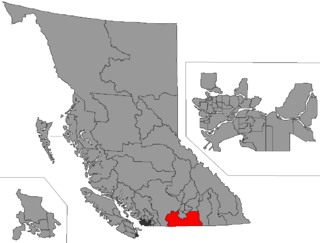
The Regional District of Okanagan-Similkameen (RDOS) is in southern British Columbia, adjacent to the U.S. state of Washington. It is bounded by Fraser Valley Regional District to the west, Thompson-Nicola Regional District and Regional District of Central Okanagan to the north, Regional District of Kootenay Boundary to the east, and by Okanogan County, Washington to the south. At the 2011 census the population was 80,742. The district covers a land area of 10,413.44 square kilometres (4,020.65 sq mi). The administrative offices are in the City of Penticton.
School District 53 Okanagan Similkameen is a school district that serves fragments of the southern Okanagan and lower Similkameen regions, which include Cawston, Hedley, Keremeos, Okanagan Falls, Oliver, and Osoyoos, totaling to six communities in the district, all of which are in British Columbia, Canada. Its main "maintenance department" office is held in Oliver, consisting of ten schools, five of which are elementary, three are high or secondary schools, while two are alternative schools. This district's superintendent is Beverly Young, while 2,665 students attend schools in it; there are 480 employees for the Okanagan Simlkammen school district. Their motto is "Learning Today for Living Tomorrow", and all places within the district are towns or villages.

The Okanagan Trail was an inland route to the Fraser Canyon Gold Rush from the Lower Columbia region of the Washington and Oregon Territories in 1858–1859. The route was essentially the same as that used by the Hudson's Bay Company fur brigades, following the Columbia River to the confluence of the Okanogan River, and then up that river's watercourse via Osoyoos, Skaha (Dog) and Okanagan lakes, then using a pass via Monte Creek to Fort Kamloops, at the confluence of the North and South Thompson rivers. From there, the route went west down the Thompson River either to the lower gold-bearing bars of the Fraser River between what is now Lytton, British Columbia and Yale, British Columbia, or via Hat Creek and Marble Canyon to the upper Fraser goldfields around present-day Lillooet, British Columbia. A shorter branch-route to the lower Thompson and lower Fraser Canyon diverged from the main route at the confluence of the Similkameen River and the Okanogan. Cayoosh and The Fountains are today's Lillooet, British Columbia and environs.
The Lower Similkameen Indian Band or Lower Smelqmix, is a First Nations band government in the Canadian province of British Columbia. Their office was in the village of Keremeos in the Similkameen region, until 2015 when they moved into their own $7million multi-purpose facility south of Cawston. They are a member of the Okanagan Nation Alliance.
The Okanagan Nation Alliance is a First Nations Tribal Council in the Canadian province of British Columbia, spanning the Nicola, Okanagan and Similkameen Districts of the Canadian province of British Columbia and also the Colville Indian Reservation in Washington state of the United States of America. Their territory covers roughly 69,000 km2 in the Canadian Province of British Columbia and also some area of Washington state in the United States of America. The diverse landscape covers deserts, lakes, forests, and grasslands.
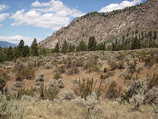
The Okanagan Basin spans two countries and comprises the basin of Okanagan Lake, the Okanogan River and tributary valleys such as that of the Similkameen and Chelan Rivers. In Canada the basin constitutes two distinct regions within British Columbia, the Similkameen Country to the west and the main Okanagan region running from the communities of Osoyoos in the south to Armstrong in the north – incorporating most of the three Okanagan regional districts and is usually known as "the Okanagan" or as the Okanagan Valley or the Okanagan Country. In the United States, the Okanogan Country is the western, lowland core of Okanogan County, which like its Canadian counterpart has a history and economy based on ranching, gold, fruit orcharding and vineyards, but the basin includes Lake Chelan and other flanking valleys. Communities in Washington's Okanogan Basin include Pateros, Omak, Okanogan, Oroville and Brewster.
The Similkameen Country, also referred to as the Similkameen Valley or Similkameen District, but generally referred to simply as The Similkameen or more archaically, Similkameen, is a region roughly coinciding with the basin of the river of the same name in the Southern Interior of British Columbia. The term "Similkameen District" also refers to the Similkameen Mining District, a defunct government administrative district, which geographically encompasses the same area, and in more casual terms may also refer to the Similkameen electoral district, which was combined with the Grand Forks-Greenwood riding by the time of the 1966 election. The Similkameen Country has deep historical connections to the Boundary Country and the two are sometimes considered one region, partly as a result of the name of the electoral district. It is also sometimes classed as being part of the Okanagan region, which results from shared regional district and other administrative boundaries and names. The term "Similkameen District" may also historically refer to the Similkameen Division Yale Land District, which also includes Osoyoos and the Boundary Country to Osoyoos' east.
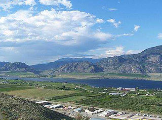
Osoyoos Lake is a lake located in British Columbia, Canada, and Washington state of the United States. Osoyoos is derived from the word sẁiẁs meaning "narrowing of the waters" in the local Okanagan language (Syilx'tsn).

The Okanagan Country, also known as the Okanagan Valley, is a region located in the Canadian province of British Columbia and the U.S. state of Washington, defined by the basin of Okanagan Lake and the Okanagan River. With an estimated 400,000 residents, the Okanagan Country spans from the Thompson Plateau near Grindrod, British Columbia in the Okanagan to the Okanagan Highland near Douglas County, Washington in the Okanogan. The largest city in the Canadian portion is Kelowna, with a metropolitan population of 222,162 residents as of 2021, while the largest city in the American portion is Omak, with 4,860 residents as of 2020. The region took its current name in honor of the Okanagan term, ukʷnaqín. The mild climate and close proximity to lakes, rivers and mountainous regions make the Okanagan Country an outdoor recreational destination. The region's economy is dominated by the primary sector industries of agriculture and forestry, although economic diversification has also occurred with retirement communities and recreational tourism. The American portion is considered to be more remote than the Canadian division, with approximately 10 percent of the population.
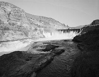
The Enloe Dam, also known as the Similkameen Dam, and its powerplant are located on the Similkameen River about 4 miles (6.4 km) west-northwest of Oroville, Washington. Located just above Similkameen (Coyote) Falls, the concrete arch-gravity dam stands about 54 feet (16 m) high, with a crest length of about 290 feet (88 m), built between 1916 and 1923. The dam was named after the president of the Okanogan Valley Power Company, Eugene Enloe. The dam was operated to generate power at its powerplant, located about 850 feet (260 m) downstream from the dam. Lacking fish ladders, Enloe Dam blocks fish passage and completely extirpated anadromous fish migration into the upper reaches of the Similkameen River and its tributaries in Canada.
South Okanagan—Similkameen National Park Reserve is a proposed national park reserve located in the Regional District of Okanagan-Similkameen of British Columbia. The goal of the park is to work with the local First Nations to protect a large patch of Okanagan dry forests and part of the northern reach of the Columbia Plateau ecoregion in Canada.