Alofi

Last updated

Alofi
Alofi.jpg
A street in Alofi
Alofi in Niue.svg
Alofi council within Niue
Niue Verwaltungsgliederung.png
Administrative map of Niue showing all the villages. Alofi is on the western side of the island
Coordinates: 19°03′15″S169°55′10″W / 19.05417°S 169.91944°W / -19.05417; -169.91944
Country New Zealand
Constituent country Niue
Tribal Area Tafiti
Village Alofi North and Alofi South
Government
  Assemblyman of Alofi NorthVaiga Tukuitoga [1]
  Assemblyman of Alofi SouthDalton Tagelagi [2]
Area
  Area of both Alofi North and Alofi South46.48 km2 (17.95 sq mi)
Elevation
[3]
21 m (69 ft)
Population
 (2022) [4]
  Total610
  Density13.12/km2 (32.46/sq mi)
  Alofi North
187
  Alofi South
423
Resident Population
[5]
  Visitors (Alofi North)6,214
  Visitor (Alofi South)6,214
Time zone UTC-11 (UTC-11)
Area code +683

Alofi is the capital of the island nation of Niue. With a population of 610 in 2022, [4] Alofi has the distinction of being the second-smallest capital city of a sovereign state by population (after Ngerulmud, capital of Palau). It consists of two villages: Alofi North and Alofi South. They collectively serve as the capital, but of the two, Alofi South hosts more government buildings, as many were moved to the southern part after Cyclone Heta.

Contents

History

In January 2004, Niue was hit by the fierce tropical storm Cyclone Heta, which killed two people and did extensive damage to the entire island. Many of Alofi's buildings were destroyed, including the hospital. Government buildings were shifted to a less exposed site 3 km (≈ 2 mi) inland from the west coast, [6] named Fonuakula, after the storm. [7] This site is within the village boundaries of Alofi South.

Geography

Overview

It is located at the centre of Alofi Bay on the west coast of the island, close to the only break in the coral reef that surrounds Niue. The bay stretches for 30% of the island's length (about seven kilometres) from Halagigie Point in the south to Makapu Point in the north.

The council's territory borders with Avatele, Hakupu, Lakepa, Liku, Makefu, Mutalau, Tamakautoga and Tuapa. [8]

Climate

Alofi
Climate chart (explanation)
J
F
M
A
M
J
J
A
S
O
N
D
 
 
260
 
 
28
23
 
 
250
 
 
29
24
 
 
300
 
 
28
24
 
 
200
 
 
27
23
 
 
130
 
 
26
22
 
 
80
 
 
26
21
 
 
90
 
 
25
20
 
 
100
 
 
25
20
 
 
100
 
 
26
21
 
 
120
 
 
26
21
 
 
140
 
 
27
22
 
 
190
 
 
28
23
Average max. and min. temperatures in °C
Precipitation totals in mm
Source: Weatherbase [3]
Imperial conversion
JFMAMJJASOND
 
 
10
 
 
82
73
 
 
9.8
 
 
84
75
 
 
12
 
 
82
75
 
 
7.9
 
 
81
73
 
 
5.1
 
 
79
72
 
 
3.1
 
 
79
70
 
 
3.5
 
 
77
68
 
 
3.9
 
 
77
68
 
 
3.9
 
 
79
70
 
 
4.7
 
 
79
70
 
 
5.5
 
 
81
72
 
 
7.5
 
 
82
73
Average max. and min. temperatures in °F
Precipitation totals in inches

Alofi features a tropical rainforest climate under the Köppen climate classification, with no discernible dry season. The city has a noticeably drier stretch from June through September. However, all of these months average more than 60 mm (2.4 in) of rain, the limit for a dry season month. Average temperatures vary slightly throughout the course of the year in Alofi hovering at around 27 °C (81 °F), during the warmest month (February) and at around 23 °C (73 °F) during the coolest months (July and August).

Climate data for Alofi
MonthJanFebMarAprMayJunJulAugSepOctNovDecYear
Record high °C (°F)38
(100)
38
(100)
32
(90)
36
(97)
30
(86)
32
(90)
35
(95)
37
(99)
36
(97)
31
(88)
37
(99)
36
(97)
38
(100)
Mean daily maximum °C (°F)28
(82)
29
(84)
28
(82)
27
(81)
26
(79)
26
(79)
25
(77)
25
(77)
26
(79)
26
(79)
27
(81)
28
(82)
27
(81)
Daily mean °C (°F)26
(79)
27
(81)
26
(79)
25
(77)
25
(77)
23
(73)
22
(72)
23
(73)
23
(73)
24
(75)
25
(77)
26
(79)
25
(77)
Mean daily minimum °C (°F)23
(73)
24
(75)
24
(75)
23
(73)
22
(72)
21
(70)
20
(68)
20
(68)
21
(70)
21
(70)
22
(72)
23
(73)
22
(72)
Record low °C (°F)20
(68)
20
(68)
20
(68)
14
(57)
15
(59)
13
(55)
11
(52)
11
(52)
15
(59)
15
(59)
11
(52)
17
(63)
11
(52)
Average precipitation mm (inches)261.6
(10.30)
253.6
(9.98)
305.6
(12.03)
202.6
(7.98)
138.2
(5.44)
88.9
(3.50)
96.4
(3.80)
105.8
(4.17)
102.4
(4.03)
123.8
(4.87)
145.5
(5.73)
196.2
(7.72)
2,018.4
(79.46)
Source: Weatherbase [9]

Transport

The town is serviced by Niue International Airport, and there are numerous roads, both paved and dirt, that crisscross the town. [10]

The island's main seaport is Sir Roberts Wharf. It is located at 19°03′10″S169°55′15″W / 19.05278°S 169.92083°W / -19.05278; -169.92083 , close to the centre of Alofi, within 200 metres of the capital's post office and just to the north of the Chamber of Commerce building. It is a small wharf, capable – due to the island's topography — of only handling smaller flat-bottomed boats. Larger cargo vessels and fishing boats moor near the reef, and barges are used to offload cargo. Major strengthening, extension work, and renovations to the wharf were commissioned in 2020, after cyclone damage earlier in the year. [11]

Personalities

See also

Related Research Articles

<span class="mw-page-title-main">Niue</span> Island country in the South Pacific Ocean

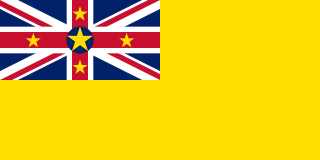
Niue is a self-governing island country in free association with New Zealand. It is situated in the South Pacific Ocean and is part of Polynesia, and predominantly inhabited by Polynesians. The island is commonly referred to as "The Rock", which comes from the traditional name "Rock of Polynesia".

The history of Niue is the history of the area and people of Niue, including its indigenous Polynesian societies. Niue was first settled by Polynesian sailors from Samoa in around 900 AD. Further settlers arrived from Tonga in the 16th century.

<span class="mw-page-title-main">Geography of Niue</span> Island in Pacific Ocean

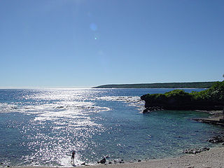
Niue is a small, oval island in the South Pacific Ocean, to the east of Tonga. It has an area of 260 square kilometres, and a coastline of 64 km. It claims an exclusive economic zone of 200 nautical miles, and a territorial sea of 12 nautical miles. It is one of world's largest coral islands.

<span class="mw-page-title-main">Transport in Niue</span>

Transport in Niue takes place on a road network, and via an (international) airport and a sea port.

<span class="mw-page-title-main">Realm of New Zealand</span> Entire area (or realm) in which the King of New Zealand is head of state

The Realm of New Zealand is the area over which the monarch of New Zealand is head of state. The realm is not a federation but is a collection of states and territories united under its monarch. New Zealand is an independent and sovereign state that has one territorial claim in Antarctica, one dependent territory (Tokelau), and two associated states. The Realm of New Zealand encompasses the three autonomous jurisdictions of New Zealand, the Cook Islands, and Niue.

<span class="mw-page-title-main">Cyclone Heta</span>

Severe Tropical Cyclone Heta was a Category 5 tropical cyclone that caused moderate damage to the islands of Tonga, Niue, and American Samoa during late December 2003 and early January 2004. Heta formed on December 25, 2003; it reached a maximum intensity of 260 km/h (160 mph) and an estimated pressure of 915 hPa before dissipating on January 11, 2004. It was the first named tropical cyclone to form during the 2003–04 South Pacific cyclone season.

<span class="mw-page-title-main">Mutalau</span> Village in Motu, Niue

Mutalau is one of the fourteen villages of Niue. Its population at the 2022 census was 77, down from 98 in 2017.

<span class="mw-page-title-main">2008 Niuean general election</span>

General elections were held in Niue on 7 June, 2008. They were initially expected to be held in April, but were delayed until June 2008. Niue has a 20-member legislative assembly, called the Niue Assembly, whose members are elected by approximately 600 registered voters. The assembly consists of 20 total members, 6 elected on a common roll and 14 representatives of the villages

<span class="mw-page-title-main">Outline of Niue</span> Overview of and topical guide to Niue

The following outline is provided as an overview of and topical guide to Niue:

<span class="mw-page-title-main">Toke Talagi</span> 5th Premier of Niue

Sir Toke Tufukia Talagi was a Niuean politician, diplomat, and statesman. He served as Premier of Niue from 2008 to 2020.

Togia Likalika Sioneholo is a Niuean politician who was a cabinet minister of Toke Talagi's government from June 2008 to May 2011 after being elected to the Niue Assembly in the June 2008 general election. He was minister for community affairs, education, justice, shipping and bulk fuels. He was formerly chief electoral officer.

<span class="mw-page-title-main">China–Niue relations</span> Bilateral relations

China-Niuean relations are relations between China and Niue.

Sam Pata Emani Tagelagi was a Niuean politician and elder. Tagelagi served as the first Speaker of the Niue Assembly from 1976 to 1993.

<span class="mw-page-title-main">Political status of the Cook Islands and Niue</span> Overview of the political status of the Cook Islands and Niue

The political status of the Cook Islands and Niue is formally defined as being states in free association within the Realm of New Zealand, which is made up of the Cook Islands, Niue, and New Zealand and its territories, Tokelau and the Ross Dependency. The Cook Islands and Niue do not have full constitutional independence from New Zealand but act as independent countries. Some countries have recognised them as sovereign entities and established diplomatic relations. However, New Zealand may carry out defence and foreign affairs on behalf of the two associated states when requested.

Niue Hotel was a hotel in Niue, Oceania, the largest on the island. The government-owned hotel was built in 1975 in the hope of stimulating tourism. It was badly damaged in 1990, but was refurbished and expanded. However, it struggled to attract guests and in 2000 was put up for sale and leased for use as a medical school. The buildings were destroyed by a hurricane in 2004.

<span class="mw-page-title-main">India–Niue relations</span> Bilateral relations

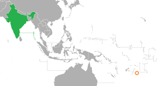
India–Niue relations are the bilateral relations between India and Niue.

Huanaki Cultural Centre & Museum was a national museum and cultural centre in Alofi in Niue, which was destroyed in 2004 by Cyclone Heta.

<span class="mw-page-title-main">Tāoga Niue Museum</span> National museum and cultural centre in Alofi, Niue

Tāoga Niue Museum is a national museum and cultural centre located in Alofi, Niue. It replaced the Huanaki Cultural Centre & Museum, which was destroyed by Cyclone Heta in 2004.

References

Notes

  1. New Zealand Ministry of Foreign Affairs and Trade
  2. Government of Niue
  3. 1 2 Weatherbase
  4. 1 2 "Niue Census of Population and Housing 2022". Niue Statistics Office. Retrieved 20 March 2024.
  5. SPC 2008, p.5.
  6. "Alofi | Encyclopedia.com". www.encyclopedia.com. Retrieved 3 September 2023.
  7. East-West Center
  8. 1558549 (x a j h) Alofi on OpenStreetMap
  9. "Weatherbase: Historical Weather for Alofi, Niue". Weatherbase. Retrieved 3 August 2009.
  10. "Niue International Airport". Archived from the original on 3 March 2016. Retrieved 26 October 2012.{{cite web}}: CS1 maint: unfit URL (link)
  11. Pavihi, Esther. "A much stronger and bigger Sir Robert's Wharf officially commissioned". Television Niue. Retrieved 20 April 2022.

Sources