Angadipuram Laterite

Last updated

Angadippuram Laterite
Town
Laterite formation on gneiss. C 009.jpg
India Kerala location map.svg
Red pog.svg
Angadippuram Laterite
Location in Kerala, India
Coordinates: 10°59′33″N76°12′15″E / 10.9925°N 76.2042°E / 10.9925; 76.2042 Coordinates: 10°59′33″N76°12′15″E / 10.9925°N 76.2042°E / 10.9925; 76.2042
CountryFlag of India.svg  India
State Kerala
District Malappuram
Languages
  Official Malayalam, English
Time zone UTC+5:30 (IST)
National Geological Monument

Angadippuram Laterite is a notified National Geo-heritage Monument [1] [2] [3] in Angadippuram town in Malappuram district in the southern Indian state of Kerala, India. The special significance of Angadippuram to laterites is that it was here that Dr. Francis Buchanan-Hamilton, a professional surgeon, gave the first account of this rock type, in his report of 1807, as "indurated clay", ideally suited for building construction. [4] [5] This formation falls outside the general classification of rocks namely, the igneous, metamorphic, or sedimentary rocks but is an exclusively "sedimentary residual product". It has generally a pitted and porous appearance. The name laterite was first coined in India, by Buchanan and its etymology is traced to the Latin word "letritis" that means bricks. [4] [5] This exceptional formation is found above parent rock types of various composition namely, charnockite, leptynite, anorthosite and gabbro in Kerala. It is found over basalt in the states of Goa, Maharashtra and in some regions of Karnataka. In Gujarat in western India, impressive formations of laterite are found over granite, shale and sandstone.. [5] [6] [7] [8]

Contents

Apart from its use as bricks in building construction, it has other substantial economic value, since it has been established that laterites are closely juxtaposed with aluminium ore (bauxite), iron ore and nickel ore mineral deposits in many parts of Kerala. [6]

A monument giving details of the Laterites over a pedestal made of laterite Laterite monument. C 002.jpg
A monument giving details of the Laterites over a pedestal made of laterite

The GSI has erected a monument at Angadippuram (see picture) where the laterite formations were first identified, as one of the 26 monuments declared as National Geological Monuments, on the occasion of the "International Conference on Laterization" held in 1979. [6]

Angadippuram is also well known as a pilgrimage centre for its famous temples, the Thirumandhamkunnu temple and the Tali temple. [9]

Geography

Kerala agro-ecological zones map Kerala ecozones map labelled3.png
Kerala agro-ecological zones map

Angadipuram is situated in the Malappuram district, which lies in northern Kerala, and is bounded on the north by Wayanad and Kozhikkode districts, on the northeast by Tamil Nadu, on the southeast and south by Palakkad District, on the southwest by Thrissur District, on the west by the Arabian Sea, and on the northwest by Kozhikode District (see Kerala eco zones map). The geographical distribution of laterite is not limited to Angadipuram in Malappuram district but it is also found in the midland regions and highlands of Kerala. Its occurrence extends to Aleppey, Quilon, Thiruvananthapuram, Kottayam, Trichur and Cannanore districts. Overall, in the landform of Kerala which has seven landscape ecological zones, laterites account for a major share of 50%. This land form comprises lateritic mesa, mounds, slopes and ridges. This dominant laterite setting is delimited between altitudes 50 metres (160 ft) and 150 metres (490 ft) (though found up to elevation 2,000 metres (6,600 ft) and extends from the northern end to the southern tip of the state. Further, as the topography changes a few kilometers from the sea to the east, there are numerous valleys called elas where patches of paddy fields, coconut and arecanut groves are seen. Incidence of laterite in other parts of India is reported in the states of Karnataka Maharashtra and Gujarat. [5] [10] [11] [12] [13]

Apart from India, its global occurrence in the form of vast deposits of lateritic bauxites with rich production is reported in Australia, Brazil, Guinea, Guyana, Suriname and Venezuela. [5]

Climate

The intense southwest Monsoon rainfall in Kerala (average annual rainfall is 3,107 mm) coupled with high temperatures (mean annual temperatures range from 25 to 27.5 °C in the coastal lowlands to 20 to 22.5 °C in the eastern highlands) and lush vegetation (belongs to the Malabar Coast moist forests of a tropical moist broadleaf forest ecoregion of southwestern India) has accentuated the chemical processes over the base rocks, which has resulted in the formation of laterites. In view of these conditions, the laterization process, which results in formation of laterites, is called the "Tropical disease of rocks". [14]

Structure

Laterite formation cut into blocks for building construction Laterite quarry, Angadipuram, India. C 004.jpg
Laterite formation cut into blocks for building construction

Laterite is a residual product created by the natural process of rocks weathering in the hot humid climatic conditions and interaction with water, oxygen and carbon dioxide. In simple terms, it is a soil formation linked to the parent rock material that has evolved because of various powers of nature in the same manner as other types of soils such as alluvial soil, regular soil and red soil. It is also inferred that paleoclimate dating back several million years has been a causative factor in laterite formation. The residue usually consists of enriched iron, aluminum and titanium oxides in varying proportions. The residue is pitted and porous in appearance. Buchanan, who discovered this formation in Kerala, in his report of 1807 observed:

It is diffused in immense masses, without any appearance of stratification and is placed over the granite that forms the basis of Malayala. It is full of cavities and pores and contains a large quantity of iron in the form of red and yellow ochres. In the mass, while excluded from air, it is so soft, that any iron instrument readily cuts it, and it is dug up in square masses with a pick-axe, and immediately cut into the shape wanted with a trowel or a large knife. It, very soon after, becomes as hard as brick, and resists air and water much better than any bricks that I have seen in India…

[15] [16] In the midland region of Kerala where lateritic soil is predominant, laterites form a residual deposit due to weathering of either crystalline or sedimentary rocks with thickness varying from 5–8 metres (16–26 ft). They also form plateaus. These laterite plateaus are attributed to various phases of uplift of the land in terraced formations in this region. However, in Malappuram, Kozhikode and Kannur districts in the plateau region, laterites are of greater thickness. [12] [17] It is also noted that top layer of laterite, over the crystalline rocks, is very compact. It is also reported by GSI that in Kerala: [17]

Quartz veins, joints and fractures can be traced from the top to the bottom of the laterite profile. The laterite profile over pyroxene granulites, metaultramafites and gneisses are characterised by relict foliation that conforms to those of the subjacent rocks which indicate the in situ nature of the laterite. Porous and spongy texture is discernible in laterites, after meta-ultramafites. Laterite derived from Tertiary sedimentary rocks is well indurated at the top for about 2–5 metres (6.6–16.4 ft). Downwards, the profile grades into soft laterite with remnants of gritstone and culminates into a zone of variegated clay.

Chemical composition

It has been inferred from chemical analysis of Angadipuram laterites that they are a derivative of charnockite. The laterite which occurs at an average elevation of about 60 metres (200 ft) in the Angadipuram area have an admixture of pyroxene granulite, charnockite and migmatite. The results of the chemical analysis of samples of these laterites indicate the following composition. [18]

Spatial variations have been recorded in the chemical composition of laterites in Kerala. [11]

Economic uses

The economic importance of laterites comes from the mining of metals, particularly nickel and aluminium. Bauxite is an aluminium-rich laterite variety, which is commercially in demand. Bauxite patches are found with laterites overlying for a thickness varying from about 1–50 metres (3.3–164.0 ft). [16] Worldwide resources inventory indicates that laterites are a major source of nickel and account for 70% of resources. But nickel production from this source is limited to about 40% of the total world production. [19] Pepper one of the commercially important spices of Kerala is grown in red laterites as it provides well drained conditions with good water holding capacity. It is also rich in humus and essential plant nutrients. [17] [20]

Access

Angadipuram has a flourishing tourist industry because of its famous temples and is located about 16 kilometres (9.9 mi) from Malappuram on the road to Palghat. It is an important railway station on the ShoranurNilambur railway line. The main road from Palghat (Palakkad) to Calicut (Kozhikode) passes through Angadipuram via Perinthalmanna. Perinthalmanna is the taluk headquarters located 1.5 kilometres (0.93 mi) from Angadipuram. The nearest airport is Calicut (Kozikode), 50 kilometres (31 mi) away. [9] [21]

Related Research Articles

<span class="mw-page-title-main">Bauxite</span> Sedimentary rock rich in aluminium

Bauxite is a sedimentary rock with a relatively high aluminium content. It is the world's main source of aluminium and gallium. Bauxite consists mostly of the aluminium minerals gibbsite (Al(OH)3), boehmite (γ-AlO(OH)) and diaspore (α-AlO(OH)), mixed with the two iron oxides goethite (FeO(OH)) and haematite (Fe2O3), the aluminium clay mineral kaolinite (Al2Si2O5(OH)4) and small amounts of anatase (TiO2) and ilmenite (FeTiO3 or FeO.TiO2). Bauxite appears dull in luster and is reddish-brown, white, or tan.

<span class="mw-page-title-main">Ultramafic rock</span> Type of igneous and meta-igneous rock

Ultramafic rocks are igneous and meta-igneous rocks with a very low silica content, generally >18% MgO, high FeO, low potassium, and are composed of usually greater than 90% mafic minerals. The Earth's mantle is composed of ultramafic rocks. Ultrabasic is a more inclusive term that includes igneous rocks with low silica content that may not be extremely enriched in Fe and Mg, such as carbonatites and ultrapotassic igneous rocks.

<span class="mw-page-title-main">Surguja district</span> District of Chhattisgarh in India

Surguja district is a district of the Indian state of Chhattisgarh. The district is one of the oldest districts of Chhattisgarh. The headquarters of the district is Ambikapur.

<span class="mw-page-title-main">Mannarkkad</span> Municipality in Kerala, India

Mannarkkad, formerly known as Mannarghat, is a municipal town in Palakkad district of the Indian state of Kerala. The Silent Valley National Park and the Attappadi Reserve Forest are located in Mannarkkad Taluk. Mannarkkad is situated 36 km away from district headquarters Palakkad on National Highway 966.

<span class="mw-page-title-main">Mankada</span> Village in Kerala, India

Mankada is a hillside village in the Malappuram district of Kerala state. It is located 15 km (9.3 mi) from Malappuram and is part of the Malappuram parliament constituency. The municipal town of Perinthalmanna is just 10 km (6.2 mi) away. Also, the municipal towns of Manjeri and Malappuram are just 15 km (9.3 mi) away. Mankada Kadannamanna Kovilakam was the seat of ruling family of the erstwhile Kingdom of Valluvanad.

<span class="mw-page-title-main">Geography of Karnataka</span>

The Indian State of Karnataka is located between 11°30' North and 18°30' North latitudes and between 74° East and 78°30' East longitude.It is situated on a tableland where the Western Ghats and Eastern Ghats converge into the complex, in the western part of the Deccan Peninsular region of India. The State is bounded by Maharashtra and Goa States in the north and northwest; by the Lakshadweep Sea in the west; by Kerala in the south-west and Tamil Nadu in the south and south-east, Andhra Pradesh in the south-east and east and Telangana in the north-east. Karnataka extends to about 850 km (530 mi) from north to south and about 450 km (280 mi) from east to west.

<span class="mw-page-title-main">Nilambur–Shoranur line</span> Railway line in India

Nilambur–Shoranur line is a 66 kilometres (41 mi)-long single-line, non-electrified broad-gauge (1676 mm) railway spur branch line of the Indian Railways connecting Nilambur Road railway station in Malappuram district with Shoranur Junction in Palakkad district in the state of Kerala. It is a branch line administered by the Palakkad railway division of the Southern Railway zone and one of the shortest broad-gauge railway lines in India. It was laid by the British in colonial era for the transportation of Nilambur Teak logs into United Kingdom through Kozhikode.

<span class="mw-page-title-main">Angadipuram</span> Town in Kerala, India

Angadippuram is a major suburb of Perinthalmanna town, in Malappuram District of Kerala. It was the capital of the powerful medieval kingdom of Valluvanad. Angadippuram is also known for Angadippuram Laterite, a notified go-heritage monument. Angadippuram is famous for its two temples, the Thirumandhamkunnu Temple and the Tali Mahadeva Temple. Kozhikode - Palakkad National Highway 966 passes through the town and Angadipuram Railway Station is one of the major railway station on the Nilambur - Shornur Line of Palakkad Division, Southern Railways. It is connected to major cities Kochi and Thiruvananthapuram through this line.

<span class="mw-page-title-main">Angadipuram railway station</span>

Angadippuram railway station is a major railway station serving the town of Angadippuram in the Malappuram District of Kerala. It lies on the scenic Nilambur–Shoranur line of Palakkad division, Southern Railways. Trains halting at the station connect the town to prominent cities in Kerala such as Nilambur, Shornur, Palakkad, Kottayam and Kochuveli. It is also the nearest railway station to Perinthalmanna (2.5 km) and Malappuram town (20 km).

<span class="mw-page-title-main">Eparchaean Unconformity</span>

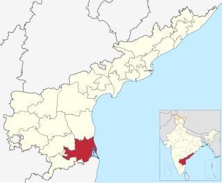
Tirupati Eparchaean Unconformity, a notified National Geo-heritage Monument is a major discontinuity of stratigraphic significance that represents a period of remarkable serenity in the geological history of the earth i.e. sudden changes and discontinuity in the rock layers in earth's crust. It is seen at the steep natural slopes, road scars and ravines in the Tirupati – Tirumala Ghat road in Tirupati district of Andhra Pradesh, India.

<span class="mw-page-title-main">Laterite</span> Product of rock weathering in wet tropical climate rich in iron and aluminium

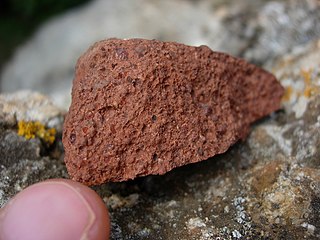
Laterite is both a soil and a rock type rich in iron and aluminium and is commonly considered to have formed in hot and wet tropical areas. Nearly all laterites are of rusty-red coloration, because of high iron oxide content. They develop by intensive and prolonged weathering of the underlying parent rock, usually when there are conditions of high temperatures and heavy rainfall with alternate wet and dry periods. Tropical weathering (laterization) is a prolonged process of chemical weathering which produces a wide variety in the thickness, grade, chemistry and ore mineralogy of the resulting soils. The majority of the land area containing laterites is between the tropics of Cancer and Capricorn.

<span class="mw-page-title-main">Saprolite</span> Chemically weathered rock

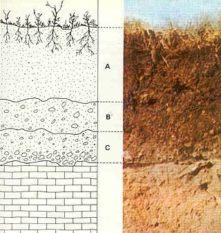
Saprolite is a chemically weathered rock. Saprolites form in the lower zones of soil profiles and represent deep weathering of the bedrock surface. In most outcrops its color comes from ferric compounds. Deeply weathered profiles are widespread on the continental landmasses between latitudes 35°N and 35°S.

Perinthalmanna is a major town and municipality in Malappuram district, Kerala, India. It serves as the headquarters of the Perinthalmanna taluk, and a block and a Revenue Division by the same name. It was formerly the headquarters of Valluvanad Taluk, which was one of the two Taluks in Malappuram Revenue Division of the erstwhile Malabar District during the British Raj. The town is located 23 kilometres (14 mi) south-west to the city of Malappuram at the centre of the Kozhikode-Malappuram-Perinthalmanna- Palakkad National Highway 966.

The 2015 Kerala fireball was a meteor air burst that occurred over Kerala state in India on 27 February 2015.

<span class="mw-page-title-main">Transportation in Malappuram district</span>

The transportation in Malappuram district includes road, rail, air, and mass transit.

<span class="mw-page-title-main">Pattikkad railway station</span>

Pattikkad railway station is a major railway station serving the town of Perinthalmanna in the Malappuram district of Kerala. It lies in the Shoranur–Mangalore section of the Southern Railways. Trains halting at the station connect the town to prominent cities in India such as Nilambur, Shoranur and Angadipuram.

<span class="mw-page-title-main">Tuvvur railway station</span>

Tuvvur railway station is a minor railway station serving the town of Tuvvur in the Malappuram district of Kerala. It lies in the Shoranur–Nilambur section of the Southern Railways. Trains halting at the station connect the town to prominent cities in India such as Nilambur, Shoranur and Angadipuram.

<span class="mw-page-title-main">Vaniyambalam railway station</span> Railway station in Kerala, India

Vaniyambalam railway station is a minor railway station serving the town of Wandoor in the Malappuram district of Kerala. It lies in the Shoranur–Mangalore section of the Southern Railways. Trains halting at the station connect the town to prominent cities in India such as Nilambur, Shoranur and Angadipuram.

The geology of Liberia is largely extremely ancient rock formed between 3.5 billion and 539 million years ago in the Archean and the Neoproterozoic, with some rocks from the past 145 million years near the coast. The country has rich iron resources as well as some diamonds, gold and other minerals in ancient sediment formations weathered to higher concentrations by tropical rainfall.

The geology of Cameroon is almost universally Precambrian metamorphic and igneous basement rock, formed in the Archean as part of the Congo Craton and the Central African Mobile Zone and covered in laterite, recent sediments and soils. Some parts of the country have sequences of sedimentary rocks from the Paleozoic, Mesozoic and Cenozoic as well as volcanic rock produced by the 1600 kilometer Cameroon Volcanic Line, which includes the still-active Mount Cameroon. The country is notable for gold, diamonds and some onshore and offshore oil and gas.

References

  1. "National Geological Monument, from Geological Survey of India website". Archived from the original on 12 July 2017. Retrieved 23 May 2017.
  2. Geo-Heritage Sites, Minister of Mines Press release, 09-March-2016
  3. national geo-heritage of India, INTACH
  4. 1 2 Buchanan, F. (1807). "A Journey from Madras through the Countries of Mysore, Canara and Malabar, Volume II" . Retrieved 17 October 2009.
  5. 1 2 3 4 5 W. Schellmann. "An Introduction in Laterite" . Retrieved 20 September 2009.
  6. 1 2 3 "Monuments of economic significance". Laterite in Angadipuram, Malappuram district, Kerala. Geological Survey of India. Archived from the original on 21 July 2011. Retrieved 20 September 2009.
  7. Geological Monuments of India. Laterite in Angadipuram, Malappuram district, Kerala. Geological Survey of India. 2001. pp. 46–48.
  8. Balasubramanyam, K. C.; Shah, S. D. (1983). Mineralogy and utilization technology of laterites from W. India. Indian Institute of Technology, Bombay. Retrieved 20 September 2009.[ permanent dead link ]
  9. 1 2 "Tourism Attractions". National Informatics Centre. Archived from the original on 6 September 2006. Retrieved 3 October 2009.
  10. "Kerala Soil and Vegetation" . Retrieved 3 October 2009.
  11. 1 2 "Sustainable Land Management in Kerala, India: A Biophysical Approach" (PDF). Landscape Ecological Analysis. pp. 5–6. Archived from the original (PDF) on 26 November 2004. Retrieved 3 October 2009.
  12. 1 2 "Introduction Chapter 1" (PDF). Geology of Kerala. pp. 4–5. Archived from the original (PDF) on 10 April 2009. Retrieved 3 October 2009.
  13. GSI Miscellaneous Publication No. 30 (reference=PGSI-101(2000). Laterite. Geological Survey of India. 1970. p. 5.
  14. "GSI" p. 46
  15. "GSI" pp. 46, 47
  16. 1 2 "Indian Soil" . Retrieved 4 October 2009.
  17. 1 2 3 "GSI Miscellaneous Publication No. 30: Geology and Mineral Resources of the States of India, Part IX – Kerala" (PDF). Laterite. Geological Survey of India. 2005. pp. 21–22. Archived from the original (PDF) on 21 July 2011. Retrieved 10 October 2009.
  18. "GSI" p. 47
  19. "The past and furute of nickel laterites". Archived from the original on 29 October 2009. Retrieved 3 October 2009.
  20. Sparks, Donald L. (2004). Advances in Agronomy, Volume 82. The Pepper Soils. Academic Press. p. 289. ISBN   978-0-12-000780-6 . Retrieved 3 October 2009.
  21. "GSI" p. 48