Antalo Limestone

Last updated
Antalo Limestone
Stratigraphic range: Oxfordian-Kimmeridgian
~163–153  Ma
Antalo Limestone at Kurkura.jpg
Formation at Kurkura village (Dogua Tembien), holding St. Mika'el's cave
Type Geological formation
Underlies Mugher Mudstone
Overlies Adigrat Sandstone
Thickness800 m (2,600 ft)
Lithology
Primary Limestone, marl, calcareous sandstone
Other Grainstone, wackestone
Location
Coordinates 13°35′52″N39°16′38″E / 13.5977°N 39.2772°E / 13.5977; 39.2772 Coordinates: 13°35′52″N39°16′38″E / 13.5977°N 39.2772°E / 13.5977; 39.2772
Approximate paleocoordinates 7°30′S26°36′E / 7.5°S 26.6°E / -7.5; 26.6
Region Tigray
CountryFlag of Ethiopia.svg  Ethiopia
Flag of Eritrea.svg  Eritrea
Extent Mekelle Outlier, Danakil Alps
Type section
Named for Antalo town
Named by William Thomas Blanford
Year defined1868
Ethiopia relief location map.jpg
Blue pog.svg
Antalo Limestone (Ethiopia)

The Antalo Limestone, also known as the Antalo Sequence, is a geological formation in Ethiopia. It is between 300 and 800 metres thick and comprises fossiliferous limestones and marls that were deposited in a reef. Marine microfossils have shown an age between 165 and 150 million years. [1] [2]

Contents

Name and definition

The Antalo Supersequence includes two main stratigraphic units: the Antalo Sequence and the Agula Group. [2] [3] The Antalo Sequence, or Antalo Limestone has been named after the town of Hintalo in Tigray, Ethiopia. The name of the formation was coined by geologist William Thomas Blanford, who accompanied the British Expedition to Abyssinia in 1868. [4] At that time, Hintalo was a major town on the route of the invading British army. [5] So far the nomenclature has not been proposed for recognition to the International Commission on Stratigraphy.

Geographical extent

The sedimentary succession is found in Ethiopia, in the Mekelle Outlier, in the Blue Nile gorge, in the Harrar Plateau and around Dire Dawa. [2]

Stratigraphic context

The Antalo Limestone overlies the Adigrat Sandstone, and is covered by the Agula Group or Agula Shale and the Mugher Mudstone.

Environment

The Antalo Limestone comprises sediment that was deposited in a shallow tropical sea in the upper Jurassic. As the region had undergone a marine transgression, it was below the sea level. At that time, what would become Ethiopia was positioned just south of the equator. [6]

Lithology

Quarry in the third member of Antalo Limestone at May Qarano in Dogu'a Tembien May Qarano quarry in Antalo Limestone.jpg
Quarry in the third member of Antalo Limestone at May Qarano in Dogu’a Tembien

The limestones and marls of the Antalo Sequence also hold shale and calcareous sandstone layers. The Antalo Limestone comprises four members: (1) a basal member with grainstone and wackestone lithologies, with marly interlayers and in the upper part stromatoporoid coral-like level; (2) sandy limestone deposited in estuaries and lagoons; (3) micritic (very fine grained) limestone with intercalations of wackestone and coquina beds deposited in relatively deep water; and (4) a succession of marls and limestone, with cherty limestone at the base. [2] [3]

Rock sample of sandy limestone (second member), collected in Addi Idaga Rock sample 11 Sandy limestone Addi Idaga.jpg
Rock sample of sandy limestone (second member), collected in Addi Idaga
Rock sample from the fourth (upper) member, collected in Miheno Rock sample 7 Upper limestone formation Miheno.jpg
Rock sample from the fourth (upper) member, collected in Miheno

Fossil content

Rock sample of Antalo Limestone with mollusks, collected in Azef Rock sample 6 Limestone with mollusks Azef.jpg
Rock sample of Antalo Limestone with mollusks, collected in Azef

The Antalo Limestone sediments were deposited at the time of dinosaurs and primitive birds. Well away from coasts, coral reefs formed the edge of the continental shelf. At shallow depth, the sea bottom was made of large mudflats, with sand bars and spits near river mouths. [6] This sea bed hosted many invertebrate animals: echinoderms, crustaceans, bivalves and gastropods were common. There was also fish. As it was not a nutrient-rich ecosystem, larger predators were rare, maybe some marine reptiles like crocodiles. A striking scavenger in this fauna was a cephalopod mollusc, a giant nautilus with a characteristic spiral shell. [6]

Invertebrates

Bivalves [7]
GenusSpeciesPresenceMaterialNotesImages
Actinostreon A. solitarium10 specimens from AL1, 65 from AL2.75 specimens.A palaeolophid.
Arcomytilus A. laitmairensisAL1 and AL2.3 left valves, 1 right valve and 4 articulated specimens.A mytilid.
Eopecten E. velatusAL1.1 left valve.A pectinid.
Gryphaea G.? (Bilobissa?) balliAL1.1 left valve.A gryphaeid.
Integricardium I. (Integricardium) cf. bannesianum7 specimens from AL1, 1 from AL2.4 left valves, 1 right valves and 3 double-valved specimens.A cardiid.
Liostrea L. sp.AL1 and AL2.2 specimens.An ostreid.
"Lucina""L." cf. cecchiiAL2.4 double-valved specimens.A lucinid.
Modiolus M. (Modiolus) imbricatus2 specimens from AL1, 1 from AL2.3 double-valved specimens.A mytilid.
Musculus M. (Musculus) somaliensisAL1 and AL2.2 articulated specimens.A mytilid.
Nanogyra N. nanaAL2.2 articulated specimens.A gryphaeid.
Pholadomya P. (Bucardiomya) somaliensis1 specimen from AL1, 6 from AL2.7 double-valved specimens.A pholadomyid.
P. (Bucardiomya) lirataAL2.1 double-valved specimen.A pholadomyid.
Plagiostoma P. harronisAL1 and AL2.3 left valves, 5 right valves and 2 articulated specimens.A limid.
P. sublaeviusculumAL2.1 left valve 1 right valve and 1 articulated specimen.A limid.
Seebachia S. ("Eoseebachia") sowerbyanaAL2.2 left valves.An astartid.
Spondylopecten S. (Spondylopecten) palinurusAL1.2 left valves.A pectinid.
Stegoconcha S. gmuelleriAL2.2 articulated specimens.A pinnid.
Brachiopods [7]
GenusSpeciesPresenceMaterialNotesImages
cf. Amydroptychus cf. A. sp.Base of AL2.10 individuals.A rhynchonellid.
Cererithyris C. sp.1 from AL1, 105 from AL2 .106 individuals.A terebratulid.
Cymatorhynchia C. sp.AL2.16 individuals.A rhynchonellid.
Daghanirhynchia D. sp.3 individuals from AL1, 51 from AL2.54 individuals.A rhynchonellid.
Monsardithyris M. sp.AL2.20 individuals.A terebratulid.
Somalirhynchia S. africanaMostly from AL2.More than 100 individuals.A rhynchonellid.
Sonalirhynchia brachial valve.jpg
Cnidarians [7]
GenusSpeciesPresenceMaterialNotesImages
Actinastrea A. crassoramosa47 specimens from AL1, 13 from AL2.60 larger fragments of colonies.A stony coral.
Coenastraea C. arabicaAL2.1 specimen.A stony coral.
Collignonastraea C. cf. grossouvreiAL2.1 specimen.A stony coral.
Columnocoenia C. gemmansAL1.2 specimens.A stony coral.
Comoseris C. meandrinoidesAL3.1 complete colony.A stony coral.
Cladophyllia C. excelsaAL3.1 specimen.A stony coral.
Cryptocoenia C. slovenica7 specimens from AL1, 4 specimens from AL2.11 specimens.A stony coral.
Ironella I. arabicaAL1.12 specimens.A stony coral.
Isastrea I. bernensis20 specimens from AL1, 22 specimens from AL2.42 specimens.A stony coral.
Kobyastraea K. lomontianaAL1.1 specimen.A stony coral.
Latiastrea L. greppini2 from AL1, 3 from AL2.5 specimens.A stony coral.
Lochmaeosmilia L. trapeziformisAL1.16 karger fragments of colonies.A stony coral.
Ovalastrea O. micheliniAL2.3 specimens (including 1 complete colony).A stony coral.
Echinoderms
GenusSpeciesPresenceMaterialNotesImages
Ausichicrinites A. zelenskyyiNearly complete specimen. [8] A comatulid.
Ausichicrinites zelenskyyi gen. et sp. nov.jpg
Pygurus P. mesleiUpper part of the formation. [9] A sea urchin.
Molluscs [10]
GenusSpeciesPresenceMaterialNotesImages
Orthosphinctes O. aff. tizianiTop part of sub-unit II.5 fragmentary specimens.An ataxioceratid ammonite.
Pachyceras P. cf. lalandeanumFrom the middle part of sub-unit II, GPS location 10°02′39.7″N, 38°13′53.7″E.One poorly preserved specimen (no. AF020).A pachyceratid ammonite.
Pachyceratidae - Pachyceras lalandeanum.JPG
Paracenoceras P. cf. ennianusTop part of sub-unit II.1 specimen (no. AF012).A nautiloid.
P. aff. prohexagonumLower Limestone Member. [11] A nautiloid.
P. cf. kumagunenseTop part of sub-unit II.1 specimen (no. AF004).A nautiloid.
P. cf. giganteumMiddle part of sub-unit II.1 specimen (no. AF005).A nautiloid.
Purpuroidea P. aff. gigasOne specimen (AF025) from the top part of sub-unit I; One specimen (AF026) from the top part of sub-unit II.2 specimen (AF025 and AF026).A gastropod.

Limestone and karst geomorphology

A spring in Antalo Limestone at Santarfa Santarfas washing place.jpg
A spring in Antalo Limestone at Santarfa

The layering is sub-horizontal, the same as that of the underlying sedimentary formations. [3] This gives rise to a structural sub-horizontal relief, with alternating cliffs and flats. Dissolution processes in limestone lead to the occurrence of caves. Most described caves in Mesozoic limestone in Ethiopia are located in the Harrar region (Sof Omar cave) and in the Dogu’a Tembien district of Tigray. [12]

Traditional uses of Antalo Limestone

Antalo Limestone is commonly used for house building; here a homestead in Addi Ateroman in Dogu'a Tembien Antalo Limestone as building material - house in Addi Ateroman in Dogu'a Tembien.jpg
Antalo Limestone is commonly used for house building; here a homestead in Addi Ateroman in Dogu’a Tembien

Given its nearly rectangular shape and its strength, the hard layers of Antalo Limestone are used for

See also

Related Research Articles

<span class="mw-page-title-main">Dogu'a Tembien</span> District in Tigray Region, Ethiopia

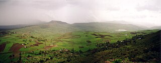
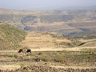
Dogu'a Tembien is a woreda in Tigray Region, Ethiopia. It is named in part after the former province of Tembien. Nowadays, the mountainous district is part of the Southeastern Tigray Zone. The administrative centre of this woreda is Hagere Selam.

<span class="mw-page-title-main">Amba Aradam Formation</span> Rock formation

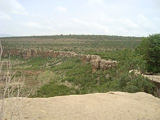
The Amba Aradam Formation is a Cretaceous sandstone formation in Ethiopia. It is up to 200 metres thick, for instance in the Degua Tembien district. As fossils are absent, the age of the Amba Aradam Formation was interpreted based on the age of assumed corresponding sandstones elsewhere in Ethiopia: the Debre Libanos Sandstones in the Blue Nile Basin, and the Upper Sandstone near Harrar in southeast Ethiopia, both of Late Cretaceous age. The lithology of the Amba Aradam Formation makes it less suitable for rock church excavation; caves have however been blasted in this formation to serve as headquarters for the TPLF during the Ethiopian Civil War of the 1980s.

<span class="mw-page-title-main">Adigrat Sandstone</span> Sandstone formation between Ethiopia and Eritrea border

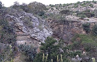
The Adigrat Sandstone formation in north Ethiopia, in a wide array of reddish colours, comprises sandstones with coarse to fine grains, and locally conglomerates, silt- and claystones. Given the many lateritic palaeosols and locally fossil wood fragments, the formation is interpreted as a deposit in estuarine, lacustrine-deltaic or continental environments. The upper limit of Adigrat Sandstone is of Middle-Late Jurassic age whereas the lower boundary is Triassic. There are numerous rock-hewn churches in this formation.

<span class="mw-page-title-main">Mika'el Abiy</span> Place in Tigray, Ethiopia

Mika’el Abiy is a tabia or municipality in the Dogu’a Tembien district of the Tigray Region of Ethiopia. The tabia centre is in Megesta village, located approximately 7 km to the southeast of the woreda town Hagere Selam.

<span class="mw-page-title-main">Melfa (Dogu'a Tembien)</span> Place in Tigray, Ethiopia

Melfa is a tabiya or municipality in the Dogu'a Tembien district of the Tigray Region of Ethiopia and ancient capital of Tembien. The tabia centre is Melfa village itself, located approximately 3 km to the west of the woreda town Hagere Selam.

<span class="mw-page-title-main">Debre Nazret</span> Municipality in Tigray Region, Ethiopia

Debre Nazret is a tabia or municipality in the Inderta district of the Tigray Region of Ethiopia. It belonged to Dogu'a Tembien up to January 2020. The tabia centre is in Togogwa town, located approximately 19 km to the east-southeast of Hagere Selam and 25 km to the west of Mekelle.

<span class="mw-page-title-main">Addi Azmera</span> Municipality in Ethiopia

Addi Azmera is a tabia or municipality in the Dogu'a Tembien district of the Tigray Region of Ethiopia. The name refers to good spring rains (“azmera”), in relation to the local microclimate. The tabia centre is in Tukhul town, located approximately half-way between the woreda town Hagere Selam and the regional capital Mekelle.

<span class="mw-page-title-main">Emni Ankelalu</span> Municipality in Ethiopia

Emni Ankelalu is a tabia or municipality in the Dogu'a Tembien district of the Tigray Region of Ethiopia. The tabia centre is in Mitslal Afras village, located approximately 20 km to the east of the woreda town Hagere Selam.

<span class="mw-page-title-main">Addilal</span> Municipality in Ethiopia

Addilal is a tabia or municipality in the Dogu'a Tembien district of the Tigray Region of Ethiopia. The tabia centre is in Addilal village, located approximately 19 km (12 mi) to the east of the woreda town Hagere Selam.

<span class="mw-page-title-main">Arebay</span> Municipality in Ethiopia

Arebay is a tabia or municipality in the Dogu'a Tembien district of the Tigray Region of Ethiopia organised around the Arebay mountain peaks. The tabia centre is in Arebay village, located approximately 13 km to the east-northeast of the woreda town Hagere Selam.

<span class="mw-page-title-main">Addi Walka</span> Municipality in Ethiopia

Addi Walka is a tabia or municipality in the Dogu'a Tembien district of the Tigray Region of Ethiopia. The tabia centre is in Kelkele village, located approximately 16 km northeast of the woreda town Hagere Selam.

<span class="mw-page-title-main">Haddinnet</span> Municipality in Tigray Region, Ethiopia

Haddinnet, also transliterated as Hadnet, is a tabia or municipality in the Dogu'a Tembien district of the Tigray Region of Ethiopia. The tabia centre is in Addi Idaga village, located approximately 6.5 km to the northeast of the woreda town Hagere Selam.

<span class="mw-page-title-main">Mahbere Sillasie</span> Municipality in Ethiopia

Mahbere Sillasie is a tabia or municipality in the Dogu'a Tembien district of the Tigray Region of Ethiopia. The tabia centre is in Guderbo village, located approximately 2.5 km to the west-northwest of the woreda town Hagere Selam.

<span class="mw-page-title-main">Simret</span> Municipality in Tigray Region, Ethiopia

Simret is a tabia or municipality in the Tanqua Millash woreda of the Tigray Region, Ethiopia, which comprises the longest cave of Tigray in Zeyi, as well as Ras Alula’s birthplace in Mennewe. The tabia centre is in Dengolo village. Until January 2020, Simret belonged to the Dogu'a Tembien district.

<span class="mw-page-title-main">Mizane Birhan</span> Municipality in Ethiopia

Mizane Birhan is a tabia or municipality in the Dogu'a Tembien district of the Tigray Region of Ethiopia. The tabia centre is in Ma’idi village, located approximately 13 km to the southeast of the woreda town Hagere Selam.

<span class="mw-page-title-main">Lim'at</span> Municipality in Ethiopia

Lim’at is a tabia in the Dogu'a Tembien district of the Tigray Region of Ethiopia. The tabia centre is in Maygwa village, located approximately 8 km to the southwest of the woreda town Hagere Selam.

<span class="mw-page-title-main">Ayninbirkekin</span> Municipality in Ethiopia

Ayninbirkekin is a tabia or municipality in the Dogu'a Tembien district of the Tigray Region of Ethiopia. Literal meaning of Ayninbirkekin in Tigrinya is "We will not bend". The tabia centre is in Halah village, located approximately 8 km to the east of the woreda town Hagere Selam. Main town is Ala'isa, situated on the ridge overseeing the Giba valley.

<span class="mw-page-title-main">Hurura</span> River in the Tembien highlands of Ethiopia

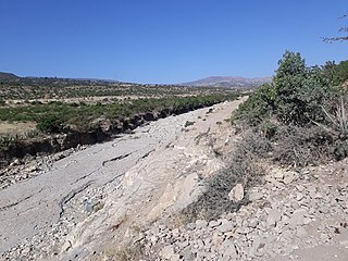
Hurura is a river of the Nile basin. Rising in the mountains of Dogu’a Tembien in northern Ethiopia, it flows southwestward to empty in Giba and finally in Tekezé River.

<span class="mw-page-title-main">Ch'eqofo River</span> River in the Tembien highlands of Ethiopia

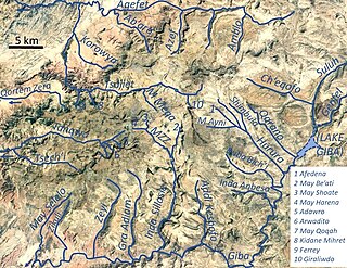
Ch’eqofo is a river of the Nile basin. Rising in the mountains of Dogu’a Tembien in northern Ethiopia, it flows southwestward to empty finally in Giba and Tekezé River.

<span class="mw-page-title-main">Agula'i River</span> River in the Tigray highlands of Ethiopia

Agula’i is a river of northern Ethiopia. Rising in the mountains of Atsbi Wenberta, it flows southwestward to Giba River which empties finally in the Tekezé River. Future Lake Giba will occupy the plain where Sulluh, Genfel and Agula’i Rivers meet.

References

  1. Sembroni, A.; Molin, P.; Dramis, F. (2019). Regional geology of the Dogu'a Tembien massif. In: Geo-trekking in Ethiopia's Tropical Mountains - The Dogu'a Tembien District. SpringerNature. ISBN   978-3-030-04954-6.
  2. 1 2 3 4 Bosellini, A.; Russo, A.; Fantozzi, P.L.; Assefa, G.; Tadesse, S. (1997). "The Mesozoic succession of the Mekelle Outlier (Tigrai Province, Ethiopia)". Mem. Sci. Geol. 49: 95–116.
  3. 1 2 3 Dramis, F.; Fubelli, G. (2019). "Limestone, Karst and Tufa Dams in the Western Part of the Mekelle Outlier". Geo-trekking in Ethiopia's Tropical Mountains. GeoGuide. Cham (CH): SpringerNature. pp. 107–119. doi:10.1007/978-3-030-04955-3_7. ISBN   978-3-030-04954-6. S2CID   199102740.
  4. Blanford, W.T. (1870). Observations on the geology and zoology of Abyssinia, made during the progress of the British expedition to that country in 1867-68. London: Macmillan and Co.
  5. Markham, C.; Prideaux, W. (1869). A history of the Abyssinian expedition. Macmillan.
  6. 1 2 3 Lerouge, F.; Aerts, R. (2019). Fossil evidence of Dogu'a Tembien's environmental past. In: Geo-Trekking in Ethiopia's Tropical Mountains, the Dogu'a Tembien District. SpringerNature. ISBN   978-3-030-04954-6.
  7. 1 2 3 Kiessling, Wolfgang; Pandey, Dhirendra Kumar; Schemm-Gregory, Mena; Mewis, Heike; Aberhan, Martin (2011). "Marine benthic invertebrates from the Upper Jurassic of northern Ethiopia and their biogeographic affinities". Journal of African Earth Sciences. 59 (2–3): 195. doi:10.1016/j.jafrearsci.2010.10.006. ISSN   1464-343X.
  8. Salamon, Mariusz A.; Jain, Sreepat; Brachaniec, Tomasz; Duda, Piotr; Płachno, Bartosz J.; Gorzelak, Przemysław (2022). "Ausichicrinites zelenskyyi gen. et sp. nov., a first nearly complete feather star (Crinoidea) from the Upper Jurassic of Africa". Royal Society Open Science. 9 (7): 220345. doi:10.1098/rsos.220345. PMC   9297031 . PMID   35875469.
  9. Radwańska, Urszula; Jain, Sreepat (2020-10-01). "First Late Jurassic echinoid record of Pygurus meslei Gauthier from the Antalo Limestone Formation (Blue Nile Basin, Ethiopia)". Journal of African Earth Sciences. 170: 103898. doi:10.1016/j.jafrearsci.2020.103898. ISSN   1464-343X. S2CID   219739555.
  10. Jain, Sreepat; Schmerold, Roland (2021). "Callovian and Kimmeridgian fossils and stratigraphy of the Blue Nile Basin (central western Ethiopia)". Annales Societatis Geologorum Poloniae. doi: 10.14241/asgp.2021.11 . ISSN   0208-9068. S2CID   239211851.
  11. Jain, Sreepat (2019-01-01). "First Bathonian (Middle Jurassic) nautiloid Paracenoceras Spath from Ethiopia". Journal of African Earth Sciences. 149: 84–96. doi:10.1016/J.JAFREARSCI.2018.07.027. ISSN   1464-343X. S2CID   134655647.
  12. Catlin, D; Largen, M; Monod, T; Morton, W (1973). "The caves of Ethiopia". Transactions of the Cave Research Group of Great Britain. 15: 107–168.
  13. Nixon-Darcus, L.A. (2014). The cultural context of food grinding equipment in Northern Ethiopia: an ethnoarchaeological approach. PhD thesis. Canada: Simon Frazer University.
  14. Gebre Teklu (2012). Ethnoarchaeological study of grind stones at Lakia'a in Adwa, Tigray Regional State, Ethiopia. PhD diss (PDF). Addis Ababa University.