The Mediterranean Sea is a sea connected to the Atlantic Ocean, surrounded by the Mediterranean Basin and almost completely enclosed by land: on the north by Western and Southern Europe and Anatolia, on the south by North Africa, and on the east by the Levant. The Sea has played a central role in the history of Western civilization. Although the Mediterranean is sometimes considered a part of the Atlantic Ocean, it is usually referred to as a separate body of water. Geological evidence indicates that around 5.9 million years ago, the Mediterranean was cut off from the Atlantic and was partly or completely desiccated over a period of some 600,000 years during the Messinian salinity crisis before being refilled by the Zanclean flood about 5.3 million years ago.

The Strait of Gibraltar, also known as the Straits of Gibraltar, is a narrow strait that connects the Atlantic Ocean to the Mediterranean Sea and separates the Iberian Peninsula in Europe from Morocco in Africa.
The pelagic zone consists of the water column of the open ocean, and can be further divided into regions by depth. The word pelagic is derived from Ancient Greek πέλαγος (pélagos) 'open sea'. The pelagic zone can be thought of as an imaginary cylinder or water column between the surface of the sea and the bottom. Conditions in the water column change with depth: pressure increases; temperature and light decrease; salinity, oxygen, micronutrients all change.

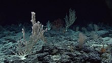
The benthic zone is the ecological region at the lowest level of a body of water such as an ocean, lake, or stream, including the sediment surface and some sub-surface layers. The name comes from ancient Greek, βένθος (bénthos), meaning "the depths." Organisms living in this zone are called benthos and include microorganisms as well as larger invertebrates, such as crustaceans and polychaetes. Organisms here generally live in close relationship with the substrate and many are permanently attached to the bottom. The benthic boundary layer, which includes the bottom layer of water and the uppermost layer of sediment directly influenced by the overlying water, is an integral part of the benthic zone, as it greatly influences the biological activity that takes place there. Examples of contact soil layers include sand bottoms, rocky outcrops, coral, and bay mud.

Bathymetry is the study of underwater depth of ocean floors, lake floors, or river floors. In other words, bathymetry is the underwater equivalent to hypsometry or topography. The first recorded evidence of water depth measurements are from Ancient Egypt over 3000 years ago. Bathymetric charts are typically produced to support safety of surface or sub-surface navigation, and usually show seafloor relief or terrain as contour lines and selected depths (soundings), and typically also provide surface navigational information. Bathymetric maps may also use a Digital Terrain Model and artificial illumination techniques to illustrate the depths being portrayed. The global bathymetry is sometimes combined with topography data to yield a global relief model. Paleobathymetry is the study of past underwater depths.

The seabed is the bottom of the ocean. All floors of the ocean are known as 'seabeds'.

The Strait of Sicily is the strait between Sicily and Tunisia. The strait is about 145 kilometres (90 mi) wide and divides the Tyrrhenian Sea and the western Mediterranean Sea, from the eastern Mediterranean Sea. The maximum depth is 316 meters (1,037 ft).

The Alboran Sea is the westernmost portion of the Mediterranean Sea, lying between the Iberian Peninsula and the north of Africa. The Strait of Gibraltar, which lies at the west end of the Alboran Sea, connects the Mediterranean with the Atlantic Ocean.

A submarine canyon is a steep-sided valley cut into the seabed of the continental slope, sometimes extending well onto the continental shelf, having nearly vertical walls, and occasionally having canyon wall heights of up to 5 km, from canyon floor to canyon rim, as with the Great Bahama Canyon. Just as above-sea-level canyons serve as channels for the flow of water across land, submarine canyons serve as channels for the flow of turbidity currents across the seafloor. Turbidity currents are flows of dense, sediment laden waters that are supplied by rivers, or generated on the seabed by storms, submarine landslides, earthquakes, and other soil disturbances. Turbidity currents travel down slope at great speed, eroding the continental slope and finally depositing sediment onto the abyssal plain, where the particles settle out.
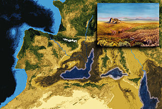
The Messinian salinity crisis (MSC), also referred to as the Messinian event, and in its latest stage as the Lago Mare event, was a geological event during which the Mediterranean Sea went into a cycle of partial or nearly complete desiccation (drying-up) throughout the latter part of the Messinian age of the Miocene epoch, from 5.96 to 5.33 Ma. It ended with the Zanclean flood, when the Atlantic reclaimed the basin.

The Lord Howe Rise is a deep sea plateau which extends from south west of New Caledonia to the Challenger Plateau, west of New Zealand in the south west of the Pacific Ocean. To its west is the Tasman Basin and to the east is the New Caledonia Basin. Lord Howe Rise has a total area of about 1,500,000 square km, and generally lies about 750 to 1,200 metres under water. It is part of Zealandia, a much larger continent that is now mostly submerged, and so is composed of continental crust.
Bottom water is the lowermost water mass in a water body, by its bottom, with distinct characteristics, in terms of physics, chemistry, and ecology.
The Integrated Marine and Coastal Regionalisation of Australia (IMCRA), formerly the Interim Marine and Coastal Regionalisation for Australia, is a biogeographic regionalisation of the oceanic waters of Australia's exclusive economic zone (EEZ). As of 2008, the most recent version is IMCRA Version 4.0.
The following outline is provided as an overview of and introduction to Oceanography.

A contourite is a sedimentary deposit commonly formed on continental rise to lower slope settings, although they may occur anywhere that is below storm wave base. Countourites are produced by thermohaline-induced deepwater bottom currents and may be influenced by wind or tidal forces. The geomorphology of contourite deposits is mainly influenced by the deepwater bottom-current velocity, sediment supply, and seafloor topography.

Hotspot Ecosystem Research and Man's Impact On European Seas (HERMIONE) is an international multidisciplinary project, started in April 2009, that studies deep-sea ecosystems. HERMIONE scientists study the distribution of hotspot ecosystems, how they function and how they interconnect, partially in the context of how these ecosystems are being affected by climate change and impacted by humans through overfishing, resource extraction, seabed installations and pollution. Major aims of the project are to understand how humans are affecting the deep-sea environment and to provide policy makers with accurate scientific information, enabling effective management strategies to protect deep sea ecosystems. The HERMIONE project is funded by the European Commission's Seventh Framework Programme, and is the successor to the HERMES project, which concluded in March 2009.

Marine habitats are habitats that support marine life. Marine life depends in some way on the saltwater that is in the sea. A habitat is an ecological or environmental area inhabited by one or more living species. The marine environment supports many kinds of these habitats. Marine habitats can be divided into coastal and open ocean habitats. Coastal habitats are found in the area that extends from as far as the tide comes in on the shoreline out to the edge of the continental shelf. Most marine life is found in coastal habitats, even though the shelf area occupies only seven percent of the total ocean area. Open ocean habitats are found in the deep ocean beyond the edge of the continental shelf.

The Zanclean flood or Zanclean deluge is a flood theorized to have refilled the Mediterranean Sea 5.33 million years ago. This flooding ended the Messinian salinity crisis and reconnected the Mediterranean Sea to the Atlantic Ocean, although it is possible that even before the flood there were partial connections to the Atlantic Ocean. The reconnection marks the beginning of the Zanclean age.

The Canadian Arctic Rift System is a major North American geological structure extending from the Labrador Sea in the southeast through Davis Strait, Baffin Bay and the Arctic Archipelago in the northwest. It consists of a series of interconnected rifts that formed during the Paleozoic, Mesozoic and Cenozoic eras. Extensional stresses along the entire length of the rift system have resulted in a variety of tectonic features, including grabens, half-grabens, basins and faults.

The Mediterranean Outflow is a current flowing from the Mediterranean Sea towards the Atlantic Ocean through the Strait of Gibraltar. Once it has reached the western side of the Strait of Gibraltar, it divides into two branches, one flowing westward following the Iberian continental slope, and another returning to the Strait of Gibraltar circulating cyclonically. In the Strait of Gibraltar and in the Gulf of Cádiz, the Mediterranean Outflow core has a width of a few tens of km. Through its nonlinear interactions with tides and topography, as it flows out of the Mediterranean basin it undergoes such strong mixing that the water masses composing this current become indistinguishable upon reaching the western side of the strait.