The Kandyan Wars refers generally to the period of warfare between the British colonial forces and the Kingdom of Kandy, on the island of what is now Sri Lanka, between 1796 and 1818. More specifically it is used to describe the expeditionary campaigns of the British Army in the Kingdom of Kandy in 1803 and 1815.
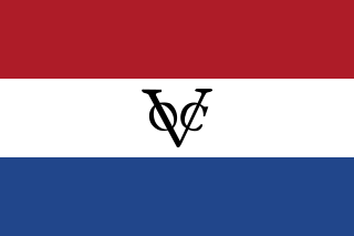
Dutch Ceylon was a governorate established in present-day Sri Lanka by the Dutch East India Company. Although the Dutch managed to capture most of the coastal areas in Sri Lanka they were never able to control the Kandyan Kingdom located in the interior of the island. Dutch Ceylon existed from 1640 until 1796.

The Nayaks of Kandy were the rulers of the Kingdom of Kandy between 1739 to 1815, and the last dynasty to rule on the island. Their rise to power came about as a result of the death of Vira Narendrasinha, who left no legitimate heir- the throne passed to his brother-in-law, who was crowned as Sri Vijaya Rajasinha in 1739.

Ceylon was a British Crown colony between 1815 and 1948. Initially the area it covered did not include the Kingdom of Kandy, which was a protectorate from 1815, but from 1817 to 1948 the British possessions included the whole island of Ceylon, now the nation of Sri Lanka.

The Kingdom of Kandy was an independent monarchy of the island of Sri Lanka, located in the central and eastern portion of the island. It was founded in the late 15th century and endured until the early 19th century.
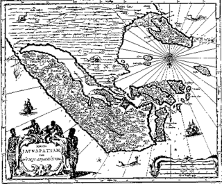
The Portuguese conquest of the Jaffna kingdom occurred after Portuguese traders arrived at the rival Kotte Kingdom in the southwest of modern Sri Lanka in 1505. Many kings of Jaffna, such as Cankili I, initially confronted the Portuguese in their attempts at converting the locals to Roman Catholicism, but eventually made peace with them.

Kirti Sri Raja Singha was the second Nayaka king of Kandy. He was a prince from the Madurai Nayak Dynasty and the brother-in-law of Sri Vijaya Raja Singha. He succeeded his brother-in-law to the throne in 1751.

Forts and fortifications in Sri Lanka date back thousands of years with many being built by Sri Lankan Kings, these include several walled cities. With the out set of colonial rule in the Indian Ocean, Sri Lanka was occupied by several major colonial empires that from time-to-time became the dominant power in the Indian Ocean. The colonists built several western styled forts, mostly in and round the cost of the island. The first to build colonial forts in Sri Lanka were the Portuguese, these forts were captured and later expanded by the Dutch. The British occupied these Dutch forts during the Napoleonic wars.

The Batticaloa Fort was built by the Portuguese in 1628 and was captured by the Dutch on 18 May 1638. From 1745, the fort was used by the British.
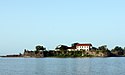
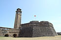
The Siege of the Portuguese fort Santa Cruz de Gale at Galle in 1640, took place during the Dutch–Portuguese and Sinhalese–Portuguese Wars. The Galle fort commanded 282 villages, which contained most fertile cinnamon lands in southern Sri Lanka It was also an important strategic coastal defense of Portuguese Ceylon. The Dutch, who were in an alliance with the Kingdom of Kandy, landed an expeditionary force under Commodore Willem Jacobszoon Coster of Akersloot, at the Bay of Galle, on 8 March 1640. After bombarding the fort for four consecutive days, Dutch troops stormed the fort and secured a victory on 13 March 1640. The Portuguese garrison, led by Captain Lourenço Ferreira de Brito, mounted a stiff resistance and unexpectedly high casualty rates among Dutch troops gave rise to the proverb “Gold in Malacca, lead in Galle”. With this victory the Dutch gained access to a large port which they later used as a convenient naval base to attack Goa and other South Indian Portuguese defenses. They also gained access to the Sri Lankan cinnamon trade and gained a permanent foothold on the island.
The Sinhalese–Portuguese War was a series of conflicts waged from 1527 to 1658 between the indigenous Sinhalese kingdoms of Ceylon and their allies against the Portuguese Empire. The Portuguese were seeking to expand from their trading post at Colombo to incorporate Ceylon into their growing empire.

Arippu Fort was built by the Portuguese and was handed over to the Dutch in 1658. The small bastion fort is located in Arippu, which is 16 km (9.9 mi) away from Mannar Island. The fort is nearly square in shape, with two bastions.
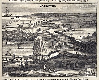
Kalutara fort was built by the Portuguese in 1622. It was located in Kalutara, Sri Lanka.
Katuwana Fort, is an inland fort constructed by the Dutch in 1646.
Koddiyar fort was the first fort that was built by Dutch in Ceylon. It was constructed in 1622 and is located on the southern side of Koddiyar Bay.
Menikkadawara fort, was a small fort located at Menikkadawara, Kegalle. The Portuguese called the place, Manicravaré or Manicavarê.

Malwana fort was located in Malwana, Gampaha, on the banks of the Kelani River. It was built by Portuguese in 1590s. The small fort served as a residence for the Portuguese Governor or Captain-Generals. Records indicate that a company of 70 soldiers were stationed at the fort. The fort was attacked by Kandyan forces in the 1630s. The Portuguese subsequently abandoned it and focused their forces on Colombo fort and its defence.
Hanwella fort was located in Hanwella, Colombo, on the banks of the Kelani River. Hanwella, which means 'skin sands', was the site of an ancient ferry route across the river. Malwana fort was situated about 15 km (9.3 mi) on the other side of the Kelani River.
Balana fort was built by the Kingdom of Kandy near Alagalla Mountain Range, Sri Lanka. The fort was functioned as a strategic rock fortress and an outpost to Kandyan kingdom. When the English established themselves in Kandy, they started tea and coffee plantations in the area of the Colombo-Kandy railway line, which has cut through tunnels in the mountains.

The History of the Kandyan Kingdom in Sri Lanka starts with its foundation in 1476.