Arba Minch

Last updated
Arba Minch (Ganta Garo)
አርባ ምንጭ (in Amharic)
City
Skyline view of AMU1.jpg
Skyline view of Arba Minch University
Ethiopia adm location map.svg
Red pog.svg
Arba Minch (Ganta Garo)
Location within Ethiopia
Coordinates: 6°2′N37°33′E / 6.033°N 37.550°E / 6.033; 37.550
Country Flag of Ethiopia.svg  Ethiopia
Region Flag of the Southern Nations, Nationalities, and Peoples' Region.svg  Southern Nations, Nationalities, and Peoples' Region
Zone Gamo Zone
Elevation
1,285 m (4,216 ft)
Population
 (2007) [1]
  Total74,879
  Estimate 
(2021) [2]
192,043
Time zone UTC+3 (EAT)
  Summer (DST) UTC+3
Climate Aw

Arba Minch (formerly called Gamo gofa) is a city and separate woreda in the southern part of Ethiopia. "Arba Minch" means "40 Springs", originated from the presence of more than 40 springs. It is located in the Gamo Zone of the South Ethiopia Regional State, about 500 kilometers south of Addis Ababa, at an elevation of 1285 meters above sea level. It is the largest town in Gamo Zone. It is surrounded by Arba Minch Zuria woreda. This Town has plenty of natural gifts including the bridge of God, Crocodile ranch, crocodile market, different fruits and vegetables, different fishes farmed from Chamo and Abaya Lakes, more than 40 springs, different cereals, and crops, surprisingly having the two big Lakes in the country, lake Abaya and Chamo, respectively, next to Lake Tana, etc. This makes the town one of the tourist destinations in Ethiopia, which comprises Nech Sar National Park, home to the country's varied wildlife and plant species.

Contents

Overview

A monument in Arba Minch Monument in Arba Minch.jpg
A monument in Arba Minch

Arba Minch received its name for the abundant local springs which produce a groundwater forest. Located at the base of the western side of the Great Rift Valley, Arba Minch consists of the uptown administrative centre of Shecha and 4 kilometers away the downtown commercial and residential areas of Sikela, which are connected by a paved road. [3] On the eastern side of Sikela is the gate to Nechisar National Park, which covers the isthmus between Lake Abaya to the north and Lake Chamo to the south. [4] Buses and taxis connect the uptown and downtown parts; both parts have schools. [5] Kulfo River flows through the town, and drains into Lake Chamo.

History

Arba Minch was founded in the early 1960s by the Fitawrari Aemeroselasie Abebe in the area locally known as "Ganta Garo". "Ganta Garo" mean in Gamo Ganta dere Language the land in which everything abundantly available for the people as well as for the animals. The city succeeded Chencha as the provincial capital city of Gamu-Gofa. [6] The oral tradition has it that Fitawrari Aemiro Selassie Abebe had to fight with prominent figures of Chencha (Aba Gaga) to move the capital from Chencha to Arba Minch (Ganta Garo). One of the reasons for Aemiroselassie Abebe to move the provincial center from Chencha to Arba Minch (Ganta Garo) was for travelers from Gidole to Chencha to take a break after a long, hot crossing of the arid Rift Valley area. This was because Arba Minch have plenty of recreational areas. Roads were built linking the new town to Soddo and making Arba Minch only a day's journey by road to the capital, Addis Ababa. [6] A telephone line connecting the town to the capital, costing E$ 250,000, was turned up on 15 July 1967. [7]

Arba Minch had previously served as a capital city for Gamo Gofa Province (Gamo Gofa Teklay Gizat), North Omo Zone (Semen Omo), Kilil 9 (Region 9), Gamo Gofa Zone, and now is serving as a capital city of Gamo Zone.

The Norwegian Lutheran Mission opened a station at Arba Minch in 1970, which included a trade school; the school's operation was later taken over by the Mekane Yesus Church. At the beginning of the Ethiopian Revolution public demonstrations occurred in the town, [8] and four people were killed in clashes with the police on 28 March 1974. [7] Following the revolution privately held plantations were made into state farms. [8]

The 193 million birr Arba Minch Textile Mill was opened on 6 May 1992 in the presence of Ethiopian Prime Minister Tamirat Layne. The mill would produce polyester mixed with cotton grey fabrics. [7] According to the SNNPR's Bureau of Finance and Economic Development, as of 2003 other amenities in Arba Minch include postal service, 24-hour electrical service, a bank and a hospital. [9] In May 2010, the Ethiopian Roads Authority awarded a contract worth 563 million E$ to the construction firm of Brehane Hagos to build a road 60 kilometers in length from this town to Belta. [10] The United States military operated a facility at Arba Minch from 2011 until September 2015. The facility served as the base for several General Atomics MQ-9 Reaper unmanned aerial vehicles. [11]

Demographics

Based on the 2007 Census conducted by the CSA, this town has a total population of 74,879, of whom 39,208 were male and 35,671 female. The majority of the inhabitants practiced Ethiopian Orthodox Christianity, with 56.04% of the population reporting that belief, 38.47% were Protestants, and 4.16% were Muslim. [12]

The 1994 national census reported this town had a total population of 40,020 of whom 20,096 were males and 19,924 were females. [13]

Transportation

Related Research Articles

<span class="mw-page-title-main">Southern Nations, Nationalities, and Peoples' Region</span> 1992–2023 regional state of Ethiopia

The Southern Nations, Nationalities, and Peoples' Region was a regional state in southwestern Ethiopia. It was formed from the merger of five kililoch, called Regions 7 to 11, following the regional council elections on 21 June 1992. Its government was based in Hawassa.

<span class="mw-page-title-main">Gamu-Gofa</span> Former province in southern Ethiopia

Gamu-Gofa was a province in the southern part of Ethiopia, named after two of the ethnic groups living within its boundaries, the Gamo and the Gofa. First incorporated into Ethiopia by Emperor Menelik II in the 1880s, its capital was first at Chencha, then around 1965 the capital was moved to Arba Minch. This province was bordered on the west and north by Kaffa, on the north and east by Sidamo, on the southeast by Lake Chew Bahir, and on the south by Kenya and Lake Turkana.

<span class="mw-page-title-main">Goba</span> Town in Oromia Region, Ethiopia

Goba is a town and separate woreda located in the Bale Zone of the Oromia Region, Ethiopia approximately 446 km southeast of Addis Ababa, this city has a latitude and longitude of 7°0′N39°59′E and an elevation of 2,743 meters above sea level.

Nechisar National Park is a national park in the Southern Nations, Nationalities, and Peoples' Region of Ethiopia. It is in the Great Rift Valley within the southwestern Ethiopian Highlands.

<span class="mw-page-title-main">Chencha</span> Place in Ethiopia

Chencha is a town in southern Ethiopia. Located in the Gamo Gofa Zone of the Southern Nations, Nationalities, and Peoples Region, 37 kilometers north of Arba Minch, Chencha has a longitude and latitude of 6°15′N37°34′E and an elevation of 2732 meters above sea level.

<span class="mw-page-title-main">Dorze people</span> Ethnic group in southern Ethiopia

The Dorze are one of the Gamo communities inhabiting the Gamo Highlands in southern Ethiopia. They speak the Dorze language, an Omotic tongue.

<span class="mw-page-title-main">North Omo Zone</span> Zone in the Southern Nations, Nationalities, and Peoples Region, Ethiopia

North Omo Zone was a zone in the Southern Nations, Nationalities, and Peoples' Region of Ethiopia. It was named after the Omo River, which flows in the western area of the former zone. In 2000 it was split into three zones: Dawro, Gamo Gofa, and Wolayita; and Basketo and Konta became special woredas.

<span class="mw-page-title-main">Amaro Zone</span> Zone in the South Ethiopia Regional State

Koore Zone (amaro)is a zone in South Ethiopia Regional State of Ethiopia. The people are called Koore and their language is Koorete. Amaro is one of the areas in which members of Koore nations widely live in. Koore got zonal status in August 2023 upon the formation of the South Ethiopia Regional State. In 2011, the Segen Area Peoples Zone was established, which includes Amaro woreda and the 3 former special woredas surrounding it. Located in the Great Rift Valley, koore is bordered on the south by Burji Zone, on the southwest by Konso Zone, on the west by Dirashe Zone, on the northwest by Gamo Zone and Lake Chamo, and on the north by Lake Abaya and in east and northeast by Oromia Region. It is divided into 35 kebeles. The administrative center of the woreda is Kelle. Jijola woreda, Derba Menena woreda, and Kereda are other growing municipals of the zone.

Boreda Abaya was one of the 77 woredas in the Southern Nations, Nationalities, and Peoples' Region of Ethiopia. Part of the Semien Omo Zone, Boreda Abaya was bordered on the south by Arba Minch Zuria, on the southwest by Chencha, on the west by Kucha, on the north by Humbo, and on the east by Lake Abaya which separates it from the Oromia Region. Aruro Island, the largest island in Lake Abaya, was administratively part of this woreda. Towns in Boreda Abaya included Birbir and Zefene. Boreda Abaya was separated for Boreda and Mirab Abaya woredas.

Chencha is a woreda in Southern Nations, Nationalities, and Peoples' Region, Ethiopia. Part of the Gamo Zone, Chencha is bordered on the south by Arba Minch Zuria, on the west by Dita & Gofa on the north by Kucha and Boreda, and on the east by Mirab Abaya. Towns in Chencha include Chencha, Dorze, Dokko and Ezo.

Bonke is one of the woredas in the Southern Nations, Nationalities, and Peoples' Region of Ethiopia. Part of the Gamo Gofa Zone, Bonke is bordered on the south by the Dirashe special woreda, on the west by the Weito River which separates it from Kemba, on the northwest by Deramalo, on the north by Dita, and on the east by Arba Minch Zuria. The major town in Bonke is Gerese.

Arba Minch Zuria is a woreda in Southern Nations, Nationalities, and Peoples' Region, Ethiopia. A part of the Gamo Zone located in the Great Rift Valley, Arba Minch Zuria is bordered on the south by the Dirashe special woreda, on the west by Bonke, on the north by Dita and Chencha, on the northeast by Mirab Abaya, on the east by the Oromia Region, and on the southeast by the Amaro special woreda. This woreda also includes portions of two lakes and their islands, Abaya found in Lante kebele and Chamo found in all Ganta Kanchama Ochole and Zeyise kebeles. Nechisar National Park is located between these lakes. City of Arba Minch is surrounded by Arba Minch Zuria.

<span class="mw-page-title-main">Lake Chamo</span> Lake in southern Ethiopia

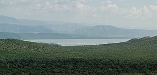
Lake Chamo is a lake in the Southern Nations, Nationalities, and Peoples' Region of southern Ethiopia. Located in the Main Ethiopian Rift, it is at an elevation of 1,110 meters. The Chamo lake is just to the south of Lake Abaya and the city of Arba Minch, east of the Guge Mountains, and west of the Amaro Mountains.

The Kulfo River is a river in southern Ethiopia that rises in the western escarpment of the Main Ethiopian Rift in the Guge mountains.

The Gamopeople are an Ethiopian ethnic group located in the Gamo Highlands of southern Ethiopia. They are found in more than 40 communities, including Chencha, Bonke, Kucha, Garbansa, Zargula, Kamba, Dorze, Birbir, Ochello, Boroda, Ganta, Gacho Baba, Eligo, Shella, Kolle, Dita, Kogo and Daramalo.

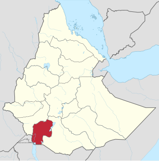
Gamo Zone is a zone in the South Ethiopia Regional State of Ethiopia. Gamo is bordered on the south by the Dirashe special woreda, on the southwest by Debub (South) Omo and the Basketo special woreda, on the northwest by Konta special woreda, on the north by Dawro and Wolayita, on the northeast by the Lake Abaya which separates it from the Oromia Region, and on the southeast by the Amaro special woreda. The administrative center of Gamo is Arba Minch.

<span class="mw-page-title-main">Wolayita Zone</span> Zone in the South Ethiopia Regional State

Wolayita or Wolaita is an administrative zone in Ethiopia. Wolayita is bordered on the south by Gamo Zone, on the west by the Omo River which separates it from Dawro, on the northwest by Kembata Zone and Tembaro Special Woreda, on the north by Hadiya, on the northeast by the Oromia Region, on the east by the Bilate River which separates it from Sidama Region, and on the south east by the Lake Abaya which separates it from Oromia Region. The administrative centre of Wolayita is Sodo. Other major towns are Areka, Boditi, Tebela, Bale Hawassa, Gesuba, Gununo, Bedessa and Dimtu.

Mirab Abaya is one of the woredas in the Southern Nations, Nationalities, and Peoples' Region of Ethiopia. Part of the Gamo Gofa Zone, Mirab Abaya is bordered on the east and south by Lake Abaya which separates it from the Oromia Region on the east and Arba Minch Zuria on the south, on the west by Chencha, on the northwest by Borena, and on the north by the Wolayita Zone. Towns in Mirab Abaya include Birbir. Mirab Abaya was part of former Boreda Abaya woreda.

Dita is one of the woredas in the Southern Nations, Nationalities, and Peoples' Region of Ethiopia. Part of the Gamo Gofa Zone, Dita is bordered on the south by Arba Minch Zuria and Bonke, on the west by Deramalo, on the north by Kucha, and on the east by Chencha. Towns in Dita include Zeda. Dita was part of former Dita Dermalo woreda.

<span class="mw-page-title-main">Arba Minch General Hospital</span> Public hospital in Arba Minch, Southern Nations, Nationalities, and Peoples Region, Ethiopia

Arba Minch General Hospital is a public hospital located in Arba Minch town, Ethiopia. It is one of the general hospitals in SNNPR region of Gamo Zone. It has a bed capacity for 200 patients.

References

  1. "Population and Housing Census 2007 – SNNPR Statistical" (PDF). Ethiopian Statistical Agency. 2007. Retrieved 31 May 2022.
  2. "Population Projection Towns as of July 2021" (PDF). Ethiopian Statistics Agency. 2021. Retrieved 31 May 2022.
  3. Briggs, Philip; Blatt, Brian (2009-01-01). Ethiopia. Bradt Travel Guides. ISBN   9781841622842.
  4. "Ethiopia: Arba Minch and Nechisar National Park Stunning Open-Air Adventures". allAfrica.com. Retrieved 2016-02-09.
  5. Philip Briggs, Ethiopia: The Bradt Travel Guide, 3rd edition (Chalfont St Peters: Bradt, 2002), p. 229
  6. 1 2 Freeman, Dena (2002). Initiating change in highland Ethiopia: causes and consequences of cultural transformation. p. 37. ISBN   9781139434898.
  7. 1 2 3 "Local History in Ethiopia" [ permanent dead link ] The Nordic Africa Institute website (accessed 6 June 2008)
  8. 1 2 Günther Schlee, Elizabeth E. Watson (2009). Changing identifications and alliances in North-East Africa, Volume 1. Vol. 2: Ethiopia and Kenya. Berghahn Books. p. 150. ISBN   9781845456030.
  9. "Detailed statistics on hotels and tourism" Archived 2011-05-31 at the Wayback Machine , Bureau of Finance and Economic Development website (accessed 4 September 2009)
  10. "Tigray, Southern Towns Get First Roads" Archived 2010-02-13 at the Wayback Machine , Addis Fortune 2 May 2010 (accessed 5 May 2010)
  11. Whitlock, Craig (4 January 2016). "Pentagon shutters African drone base, moves aircraft to other hotspots". The Washington Post. Retrieved 5 January 2016.
  12. Census 2007 Tables: Southern Peoples, Nations and Nationalities Region Archived November 13, 2012, at the Wayback Machine , Tables 2.1, and 3.4.
  13. "Population and Housing Census 1994 – SNNPR Region" (PDF). Ethiopian Statistical Agency. 1994. Retrieved 31 May 2022.