External links
- Hellenic Ministry of Culture and Tourism / in Greek
- ancient-greece.org
- www.interkriti.org
- www.planetware.com
| | This article related to a museum in Greece is a stub. You can help Wikipedia by expanding it. |
| International | |
|---|---|
| Artists | |
The Archaeological Museum of Sitia is a museum in Sitia of Crete, in Greece. Its collection consists of Minoan-era finds from Sitia, Zakros, Petra and Palaikastro.
| | This article related to a museum in Greece is a stub. You can help Wikipedia by expanding it. |
| International | |
|---|---|
| Artists | |

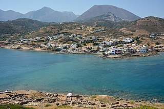
Sitia is a port town and a municipality in Lasithi, Crete, Greece. The town has 9,912 inhabitants (2011) and the municipality has 18,318 (2011). It lies east of Agios Nikolaos and northeast of Ierapetra. Sitia port is on the Sea of Crete, part of the Aegean Sea and is one of the economic centers of the Lasithi region. European route E75, which ends in Vardø, starts in Sitia. Sitia is served by the Sitia Public Airport. Sitia has not experienced the effects of mass tourism even though there is a long beach along the road leading to Vai and several places of historical interest.
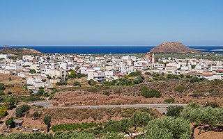
Palaikastro or Palekastro, with the Godart and Olivier abbreviation PK, is a thriving town, geographic heir to a long line of settlements extending back into prehistoric times, at the east end of the Mediterranean island Crete. The Kallikratis Programme implemented starting 2011 made the town into a local community under jurisdiction of the next-highest levels, chained as follows: municipal unit Itanos, municipality (demos) Sitia, regional unit Lasithi, region (periphereia) Crete.

Psychro Cave is an ancient Minoan sacred cave in Lasithi plateau in the Lasithi district of eastern Crete. Psychro is associated with the Diktaean Cave, one of the putative sites of the birth of Zeus. Other legends place Zeus' birthplace as Idaean Cave on Mount Ida. According to Hesiod, Theogony, Rhea gave birth to Zeus in Lyctus and hid him in a cave of Mount Aegaeon. Since the late nineteenth century the cave above the modern village of Psychro has been identified with Diktaean Cave, although there are other candidates, especially a cave above Palaikastro on Mount Petsofas.
Achladia is the archaeological site of an ancient Minoan villa on eastern Crete.

Hagia Photia is an archaeological site of a fortified ancient Minoan building on eastern Crete. Sitia lies five kilometers to the west.
Itanos is a municipal unit of the municipality (demos) Siteia in the Lasithi regional unit, eastern Crete, Greece. A former municipality itself, it was included in Siteia as part of the 2011 local government reform. The municipal unit has an area of 197.406 km2 (76.219 sq mi).

Thrypti is a mountain range in Lasithi in eastern Crete, Greece. It trends to the northeast from Ierapetra in the southwest in the direction of Sitia. However, it only goes half-way in that direction. The rest of the distance is completed by the distinct Ornon mountains, separated from the Thrypti by the Bebonas river valley, and the lower Western Siteia Foothills covering the space between the Ornon range and Sitia itself. The highest peak of Thrypti is Afentis, which is 1,476 m amsl. The three ranges constitute the West Sitia Mountains.

Ziros is a village in the municipality Sitia, Lasithi regional unit, Crete, Greece. It was the seat of government for the former municipality Lefki.

Karydi or Karidi, officially Καρύδιον (Σητείας), is a village in the highlands of east Crete, Greece, part of the municipal unit Itanos. Under the Kallikratis Programme of 2011 it was made a local community. Its chain of civic jurisdiction is as follows: municipal unit Itanos, municipality (demos) Sitia, regional unit Lasithi, region (periphereia) Crete. Until 2017 Karydi shared Itanos with Palaikastro, Zakros, and Mitato (Μητάτο). With the diminishment of Mitato village to no permanent residents the government abolished it in Presidential Decree No. 70/207 and turned over its settlements to Palaikastro.
The Archaeological Museum of Agios Nikolaos is a museum in Agios Nikolaos, Crete, Greece. It is currently open on Saturdays and Sundays 09:30 - 15:30 as of 23 April, 2023, and will fully re-open in October 2023.

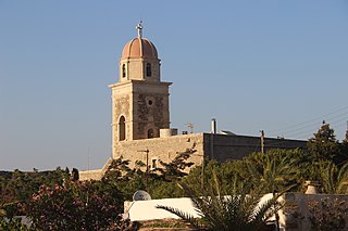
Toplou Monastery is a currently active monastery located in a semi-arid area of the Lasithi regional unit, on the eastern part of the island of Crete in Greece. It is about 6 km (3.7 mi) north of Palekastro and 85 km (53 mi) east of Agios Nikolaos. It is at the base of the Itanos promontory from which Cape Sidero, the easternmost point of Crete, projects to the northeast. The nearest settlements are Sitia to the west and Palaikastro to the southeast; otherwise, the entire promontory is uninhabited except for the modern military reservation at the tip of the cape. In the political structure of Greece, the monastery has been assigned the settlement (oikismos) of Toplou, which it had before 2011, but was validated again in the redivision of 2011. The full civic classification beyond Toplou from 2011 in ascending order is: local community Palaikastro, municipal unit Itanos, municipality (demos) Siteia, regional unit Lasithi, region (periphereia) Crete.

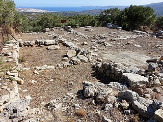
Roussolakkos is the site of a Minoan city, located near Palekastro, Crete. The Bronze Age town was occupied from Early Minoan IIA to Late Minoan IIIB, and its remains are relatively well preserved. A later Greek temple to Diktaian Zeus was built at the nearby Elaea promontory.

Greek National Road 90, also known as VOAK is the longest National Highway on the island of Crete, Greece. It runs along the north coast of the island Crete. It connects Kissamos in the west with Siteia in the east, via Chania, Rethymno, Heraklion and Agios Nikolaos.
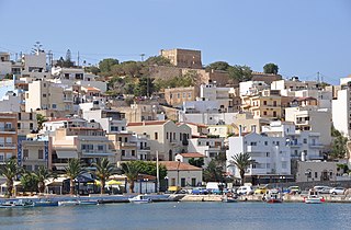
Kazarma is the Venetian-era fortress of the city of Sitia in Crete, Greece. This fortress was built in the 13th Century during Venetian rule on Crete. The Venetians abandoned the town in 1651 and destroyed parts of the fortress to prevent its use by the Turks.
Stavrochori is an historic village of eastern Crete. It belonged to the former province of Sitia and later to the former Makry Gialos municipality. Today it is part of Ierapetra municipality. It is located in a wooded valley, 29 kilometers north east from Ierapetra and 35 kilometers southwest from Sitia. Once it was the most populous village of the region and the administrative center of the surrounding settlements. Since the last 30 years, the majority of its population has moved to the seaside settlement of Koutsouras, 7 kilometers to the south. Stavrochori is a traditional village with many sights. It is also the birthplace of Ioannis Papachatzakis or "Stravogiannios", a violinist, who lived and died in Ierapetra. He was one of the most important Cretan traditional organ players of the last century.
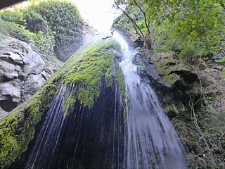
Richtis Gorge is a gorge in Crete, Greece. It is a state protected park near Exo Mouliana, Sitia, eastern Crete (Greece) that starts at the traditional village Exo Mouliana, which is located on the national road between Agios Nikolaos and Sitia and ends at the secluded Richtis beach, just east of the village Kalavros. The hiking trail is about 4 km in length of moderate (spring/summer/autumn) to hard (winter) difficulty. Elevation difference between the starting point and the beach is about 350 meters. Rich vegetation and animal life can be observed along the way, as well as old stone bridges and water mills before it culminates with the Richtis Waterfall and beach, making Richtis gorge trail one of the most diversified hiking experiences in Crete.
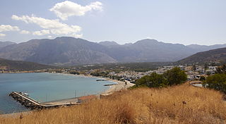
The Sitia or Siteia Mountains, also known as the Sitiaka Range, are a group of four mountain ranges extending SW-NE in Lasithi in eastern Crete, Greece. Stretching from the southern coast to the plain of the city of Sitia on the northern coast, they tend to isolate east Crete from the rest of Crete, creating a refugium for the rare plant and animal species and a refuge for the ancient people practising the Minoan culture. In this ancient refuge are now to be found the ruins of Minoan sites at Mochlos, Kato Zakro, Palaikastro, and Kavousi. These are four of the major sites of East Crete, but the number of sites recorded or excavated is in the hundreds. Endemic species, many rare or endangered, are to be found in the gorges that cut from upland to ocean or valley on all sides.
Pacheia Ammos is a village in the municipality of Ierapetra on the island of Crete in Greece. It is located on the north coast of the island, 15 km to the north of the city of Ierapetra, at the fork in the road that leads to Heraklion in the west and Sitia in the east.
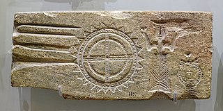
The Minoan Moulds of Palaikastro are two double-sided pieces of schist, formed in the Minoan period as casting moulds for plaques with figures and symbols. These include female figures with raised arms, labrys double axes and opium poppy flowers or capsules, two double axes with indented edges, the Horns of Consecration symbol, and a sun-like disc with complex markings, which has been claimed by some researchers to be for making objects to use in astronomical predictions of solar and lunar eclipses.

The Coastal Hill Range, East Crete is a mountain range in Lasithi in eastern Crete, Greece. It trends to the northeast from Xerokampos in the southwest in the direction of Cape Sidero. The range, however is drowned on the eastern slopes by the Kasos Strait, a deepwater channel between the island of Kasos and the island of Crete. Its peaks thus become headlands, islands, or near-surface elevations, while the cols between them are typically beaches.