Ardmore, Tennessee

Last updated

Ardmore, Tennessee
Ardmore-Main-tn.jpg
Buildings along Main Street (SR 7)
Giles County Tennessee Incorporated and Unincorporated areas Ardmore Highlighted 4701640.svg
Location in Giles County,Tennessee
USA Tennessee location map.svg
Red pog.svg
Ardmore
Location in Tennessee
Usa edcp location map.svg
Red pog.svg
Ardmore
Location in the United States
Coordinates: 35°0′17″N86°51′5″W / 35.00472°N 86.85139°W / 35.00472; -86.85139
Country United States
State Tennessee
Counties Giles, Lincoln
Founding1911
Government
  MayorMike Magnusson [1]
Area
[2]
  Total4.71 sq mi (12.19 km2)
  Land4.70 sq mi (12.17 km2)
  Water0.01 sq mi (0.02 km2)
Elevation
886 ft (270 m)
Population
 (2020) [3]
  Total1,217
  Density259.05/sq mi (100.02/km2)
Time zone UTC-6 (Central (CST))
  Summer (DST) UTC-5 (CDT)
ZIP code
38449
Area code 931
FIPS code 47-01640 [4]
GNIS feature ID1304866 [5]
Website www.cityofardmoretn.com

Ardmore is a city in Giles and Lincoln counties, Tennessee, United States. The population was 1,213 at the 2010 census. [6] Ardmore is the site of a Tennessee Department of Tourist Development Welcome Center. It borders its sister city, Ardmore, Alabama.

Contents

History

Ardmore began in 1911 as a railroad stop named "Austin" after a store owner, Alex Austin, who served construction crews working on the nearby L&N Railroad (now CSX) line that would connect Nashville, Tennessee, and Decatur, Alabama. When the L&N opened a depot in 1914, it changed the town's name to "Ardmore." [7] The name was likely inspired by Ardmore, Pennsylvania. [8] Ardmore, Tennessee, incorporated in 1949. [9]

Geography

Ardmore is located at 35°0′17″N86°51′5″W / 35.00472°N 86.85139°W / 35.00472; -86.85139 (35.004746, -86.851402). [10] The city is concentrated along Tennessee State Route 7 (Main Street), which runs congruent with Alabama State Route 53 along the state line before veering northwestward to its intersection with Interstate 65 and U.S. Route 31 in the western part of the city. US 31 connects Ardmore with Elkton, Tennessee, which lies to the northwest, and Tennessee State Route 110 connects Ardmore with Fayetteville to the northeast. Ardmore is the southern terminus of U.S. Bicycle Route 23.

According to the United States Census Bureau, the city has a total area of 4.5 square miles (12 km2), of which 0.22% is water. Ardmore's business district is located primarily in Giles County, though the eastern parts of the city are located in Lincoln County. The Elk River passes northwest of Ardmore.

Climate

Climate data for Ardmore, Tennessee, 1991–2020 normals, extremes 20082020
MonthJanFebMarAprMayJunJulAugSepOctNovDecYear
Record high °F (°C)76
(24)
81
(27)
85
(29)
89
(32)
96
(36)
102
(39)
102
(39)
100
(38)
99
(37)
96
(36)
88
(31)
78
(26)
102
(39)
Mean daily maximum °F (°C)51.9
(11.1)
57.4
(14.1)
66.1
(18.9)
75.0
(23.9)
81.5
(27.5)
87.7
(30.9)
90.8
(32.7)
90.5
(32.5)
85.3
(29.6)
76.3
(24.6)
64.8
(18.2)
55.1
(12.8)
73.5
(23.1)
Daily mean °F (°C)40.9
(4.9)
45.1
(7.3)
53.1
(11.7)
61.7
(16.5)
70.0
(21.1)
77.2
(25.1)
80.5
(26.9)
79.3
(26.3)
73.5
(23.1)
62.9
(17.2)
51.8
(11.0)
43.9
(6.6)
61.7
(16.5)
Mean daily minimum °F (°C)29.9
(−1.2)
32.7
(0.4)
40.0
(4.4)
48.3
(9.1)
58.4
(14.7)
66.7
(19.3)
70.1
(21.2)
68.0
(20.0)
61.7
(16.5)
49.4
(9.7)
38.7
(3.7)
32.7
(0.4)
49.7
(9.9)
Record low °F (°C)3
(−16)
6
(−14)
16
(−9)
29
(−2)
38
(3)
51
(11)
55
(13)
56
(13)
45
(7)
27
(−3)
17
(−8)
12
(−11)
3
(−16)
Average precipitation inches (mm)4.77
(121)
5.39
(137)
5.44
(138)
5.10
(130)
3.82
(97)
4.90
(124)
4.92
(125)
3.57
(91)
3.54
(90)
3.22
(82)
4.01
(102)
7.00
(178)
55.68
(1,415)
Source 1: NOAA [11]
Source 2: XMACIS2 [12]

Demographics

Historical population
CensusPop.Note
1950 157
1960 19524.2%
1970 601208.2%
1980 83538.9%
1990 8663.7%
2000 1,08224.9%
2010 1,21312.1%
2020 1,2170.3%
Sources: [13] [14] [3]

2020 census

Ardmore racial composition [15]
RaceNumberPercentage
White (non-Hispanic)1,07988.66%
Black or African American (non-Hispanic)352.88%
Native American 10.08%
Asian 80.66%
Pacific Islander 10.01%
Other/Mixed 574.68%
Hispanic or Latino 362.96%

As of the 2020 United States census, there were 1,217 people, 547 households, and 333 families residing in the city.

2000 census

As of the census [4] of 2000, there were 1,082 people, 427 households, and 306 families residing in the city. The population density was 238.6 inhabitants per square mile (92.1/km2). There were 480 housing units at an average density of 105.8 per square mile (40.8/km2). The racial makeup of the city was 96.86% White, 1.76% African American, 0.65% Native American, 0.09% Asian, 0.37% from other races, and 0.28% from two or more races. Hispanic or Latino of any race were 1.39% of the population.

Ardmore Veterans Memorial, with the U.S. flag and state flags of Alabama and Tennessee Ardmore TN.JPG
Ardmore Veterans Memorial, with the U.S. flag and state flags of Alabama and Tennessee

There were 427 households, out of which 31.1% had children under the age of 18 living with them, 55.7% were married couples living together, 12.9% had a female householder with no husband present, and 28.3% were non-families. 26.7% of all households were made up of individuals, and 14.3% had someone living alone who was 65 years of age or older. The average household size was 2.35 and the average family size was 2.82.

In the city, the population was spread out, with 22.6% under the age of 18, 5.9% from 18 to 24, 26.3% from 25 to 44, 23.9% from 45 to 64, and 21.3% who were 65 years of age or older. The median age was 40 years. For every 100 females, there were 82.2 males. For every 100 females age 18 and over, there were 77.2 males.

The median income for a household in the city was $33,571, and the median income for a family was $40,329. Males had a median income of $35,486 versus $25,391 for females. The per capita income for the city was $18,047. About 11.5% of families and 14.5% of the population were below the poverty line, including 21.5% of those under age 18 and 21.0% of those age 65 or over.

Related Research Articles

<span class="mw-page-title-main">Etowah County, Alabama</span> County in Alabama, United States

Etowah County is a county located in the northeastern part of the U.S. state of Alabama. As of the 2020 census the population was 103,436. Its county seat is Gadsden. Its name is from a Cherokee word meaning "edible tree". In total area, it is the smallest county in Alabama, but one of the most densely populated. Etowah County comprises the Gadsden Metropolitan Statistical Area.

<span class="mw-page-title-main">Morgan County, Alabama</span> County in Alabama, United States

Morgan County is a county in the north-central part of the U.S. state of Alabama. As of the 2020 census, its population was 123,421. The county seat is Decatur. On June 14, 1821, it was renamed in honor of American Revolutionary War General Daniel Morgan of Virginia. It is a prohibition or dry county, although alcohol sales are allowed in the cities of Decatur, Hartselle, and Priceville. Morgan County is included in the Decatur, AL Metropolitan Statistical Area, which is also included in the Huntsville-Decatur-Albertville, AL Combined Statistical Area. It is a part of the North, Northwest, and North-Central regions of Alabama.

<span class="mw-page-title-main">Limestone County, Alabama</span> County in Alabama

Limestone County is a county of the U.S. state of Alabama. As of the 2020 census, the county's population was 103,570. Its county seat is Athens. The county is named after Limestone Creek. Limestone County is included in the Huntsville, AL Metropolitan Statistical Area.

<span class="mw-page-title-main">Marshall County, Alabama</span> County in Alabama, United States

Marshall County is a county of the state of Alabama, United States. As of the 2020 census the population was 97,612. Its county seat is Guntersville. A second courthouse is in Albertville. Its name is in honor of John Marshall, famous Chief Justice of the United States. Marshall County is a dry county, with the exception of the four cities of Albertville, Arab, Guntersville, and Boaz. Marshall County comprises the Albertville, AL Micropolitan Statistical Area, which is also included in the Huntsville-Decatur-Albertville, AL Combined Statistical Area.

<span class="mw-page-title-main">Lincoln County, Tennessee</span> County in Tennessee, United States

Lincoln County is a county located in the south central part of the U.S. state of Tennessee. As of the 2020 census, the population was 35,319. Its county seat and largest city is Fayetteville. The county is named for Major General Benjamin Lincoln, an officer in the American Revolutionary War.

<span class="mw-page-title-main">Opp, Alabama</span> City in Alabama, United States

Opp is a city in Covington County, Alabama, United States. At the 2020 census, the population was 6,771. Opp is named after Henry Opp, a lawyer for the Louisville and Nashville Railroad.

<span class="mw-page-title-main">Sardis City, Alabama</span> Town in Alabama, United States

Sardis City is a town in Etowah and Marshall counties in the U.S. state of Alabama. It is part of the Gadsden Metropolitan Statistical Area. It originally incorporated in May 1963 under the name of "Sardis". It became Sardis City in the 1980s. At the 2020 census, the population was 1,814.

<span class="mw-page-title-main">Hytop, Alabama</span> Town in Alabama, United States

Hytop is a town in Jackson County, Alabama, United States. It incorporated on May 17, 1991. As of the 2010 census, the population of the town was 354, up from 315 in 2000. The Walls of Jericho, a popular hiking area, is located just north of Hytop.

<span class="mw-page-title-main">Skyline, Alabama</span> Town in Alabama, United States

Skyline is a town in Jackson County, Alabama, United States. The town incorporated in 1985. As of the 2010 census, the population of the town was 851, up from 843 in 2000.

<span class="mw-page-title-main">Ardmore, Alabama</span> Town in Alabama, United States

Ardmore is a town in Limestone County, Alabama, United States, and is included in the Huntsville-Decatur Metro Area. As of the 2010 census, the population of the town is 1,194. It borders its sister city Ardmore, Tennessee.

<span class="mw-page-title-main">Hartselle, Alabama</span> City in Alabama, United States

Hartselle is the second largest city in Morgan County, Alabama, United States, 13 miles (21 km) south of Decatur. It is part of the Decatur Metropolitan Area and the Huntsville-Decatur Combined Statistical Area.

<span class="mw-page-title-main">Pelham, Alabama</span> City in Alabama, United States

Pelham is a city in Shelby County, Alabama, United States. It incorporated in July 1964 and is a suburb located in the Birmingham metropolitan area, Alabama which was home to over 1.1 million residents as of the 2020 census. At the 2000 census the population was 14,369, and has grown to 24,318 by the 2020 census, nearly doubling. It was named for Confederate Civil War officer John Pelham.

<span class="mw-page-title-main">Manchester, Tennessee</span> City in Tennessee, United States

Manchester is a city in Coffee County, Tennessee, United States. The population was 12,213 at the 2020 census. It is the county seat of Coffee County. The city is located halfway between Nashville and Chattanooga on Interstate 24.

<span class="mw-page-title-main">Gallaway, Tennessee</span> City in Tennessee, United States

Gallaway is a city in Fayette County, Tennessee, United States. The population was 680 at the 2010 census.

<span class="mw-page-title-main">Elkton, Tennessee</span> City in Tennessee, United States

Elkton is a city in Giles County, Tennessee, United States. The population was 578 at the 2010 census.

<span class="mw-page-title-main">Minor Hill, Tennessee</span> City in Tennessee, United States

Minor Hill is a city in Giles County, Tennessee, United States. The population was 537 at the 2010 census.

<span class="mw-page-title-main">Loretto, Tennessee</span> City in Tennessee, United States

Loretto is a city in Lawrence County, Tennessee, United States. The population was 1,714 at the 2010 census, and 1,739 at the 2020 census.

<span class="mw-page-title-main">Clifton, Tennessee</span> City in Tennessee, United States

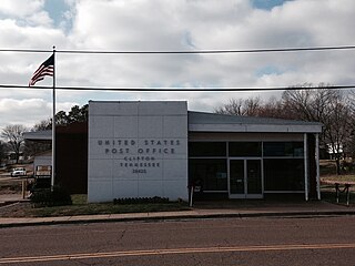
Clifton is a city in Wayne County, Tennessee, on the state's south central border with Alabama. It developed as a river port along the Tennessee River in the 19th century. Its historic districts listed on the National Register of Historic Places are associated with this period. The population was 2,694 at the 2010 census.

<span class="mw-page-title-main">Collinwood, Tennessee</span> City in Tennessee, United States

Collinwood is a city in Wayne County, Tennessee, United States. The population was 982 at the 2010 census, down from 1,024 in 2000.

<span class="mw-page-title-main">Petersburg, Tennessee</span> Town in Tennessee, United States

Petersburg is a town in Lincoln and Marshall counties in the U.S. state of Tennessee. The population was 580 at the 2000 census and 544 at the 2010 census. It used to be the location of Morgan school before consolidation

References

  1. "Mayor Mike Magnusson". cityofardmoretncom. Retrieved November 22, 2023.
  2. "ArcGIS REST Services Directory". United States Census Bureau. Retrieved October 15, 2022.
  3. 1 2 "Census Population API". United States Census Bureau. Retrieved October 15, 2022.
  4. 1 2 "U.S. Census website". United States Census Bureau . Retrieved January 31, 2008.
  5. "US Board on Geographic Names". United States Geological Survey. October 25, 2007. Retrieved January 31, 2008.
  6. "Race, Hispanic or Latino, Age, and Housing Occupancy: 2010 Census Redistricting Data (Public Law 94-171) Summary File (QT-PL), Ardmore city, Tennessee". United States Census Bureau . Retrieved October 31, 2011.
  7. History of Ardmore," Ardmore, Tennessee, official website. Accessed: 20 September 2017.
  8. James P. Kaetz, "Ardmore," Encyclopedia of Alabama, 14 December 2012.
  9. Larry Miller, Tennessee Place Names (Indiana University Press, 2001), p. 7.
  10. "US Gazetteer files: 2010, 2000, and 1990". United States Census Bureau. February 12, 2011. Retrieved April 23, 2011.
  11. "U.S. Climate Normals Quick Access – Station: Ardmore, TN". National Oceanic and Atmospheric Administration. Retrieved February 27, 2023.
  12. "xmACIS2". National Oceanic and Atmospheric Administration. Retrieved February 27, 2023.
  13. "Census of Population and Housing: Decennial Censuses". United States Census Bureau . Retrieved March 4, 2012.
  14. "Incorporated Places and Minor Civil Divisions Datasets: Subcounty Resident Population Estimates: April 1, 2010 to July 1, 2012". Population Estimates. U.S. Census Bureau. Archived from the original on June 11, 2013. Retrieved December 11, 2013.
  15. "Explore Census Data". data.census.gov. Retrieved December 24, 2021.

35°00′17″N86°51′05″W / 35.004746°N 86.851402°W / 35.004746; -86.851402