Ardotalia

Last updated

Ardotalia (Melandra Castle)
Ardotalia 5581.JPG
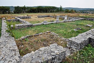
The fort today looking towards Longdendale
Derbyshire UK location map.svg
Archaeological site icon (red).svg
Map showing the location of Ardotalia within Derbyshire.
LocationHigh Peak, Derbyshire
RegionEast Midlands
Coordinates 53°27′09″N1°59′17″W / 53.45250°N 1.98806°W / 53.45250; -1.98806
TypeRoman fort
History
FoundedCohors Primae Frisiavonum—The First Cohort of Frisiavones
Associated with3rd Cohort of Bracara Augustani
Official nameMelandra Castle Roman fort
Reference no.1004595

Ardotalia (from British Celtic for "high dark hill"), also known as Melandra or Melandra Castle, is a Roman fort in Gamesley, near Glossop in Derbyshire, England. [1]

The western ramparts Ardotalia 5574.JPG
The western ramparts
Track through the centre of the fort At Glossop 2023 09.jpg
Track through the centre of the fort

Ardotalia was constructed by Cohors Primae Frisiavonum—The First Cohort of Frisiavones. [2] Evidence for the existence of this unit exists not only from the building stone found at the site but also from various diplomas and other Roman writings. [2] This unit would have had around a thousand men, including the specialist craftsmen needed to perform the skilled work of building the fort. [3]

This unit was assisted in constructing the fort by the 3rd Cohort of Bracara Augustani. These men were probably Iberian Celts from the colony of Braga in Portugal, who seem to have been attached to the XX Legion Valeria Victrix in Chester.

Whilst it is unknown which of these Cohorts manned the fort, it seems more likely that the 3rd Cohort of Bracara Augustani performed this duty, as they were from a hilly region and so were more experienced in holding terrain such as that found around Glossop. The Frisiavones were from low-lying lands beyond the Rhine and so may have been divided between the lower terrain of Manchester and Northwich. [3]

The First Cohort of Frisiavones were also present at Brocolitia, one of Hadrian's wall forts and settlements, at Carrawburgh, Northumberland. Evidence for this relies on an inscription on an altar stone, which tells us that Optio Maus (an NCO within the Cohort) had repaid a vow to the goddess Coventina. [2] Whether this altar was the repayment of the vow is unknown.

The name Melandra is of unknown origin but may have been originated by the John Watson, Rector of Stockport, who visited the site c. 1771 when substantial stone remains existed. [4] The name Ardotalia is a hypothetical emendation of Zerdotalia written in the Ravenna Cosmography. [5] The fort was excavated in the late 1800s. The towers were described by Charles Roeder: "They are built square and stand detached, 4 feet away from the angles, measuring 10 feet by 11 feet, the walls being 3 feet thick." [6]

An excavation by Hamnett and Garstang was further described by Roeder, reporting:

"Two sides ditched, the other sides naturally defended, standing on sharp slopes. Still awaiting excavation."

"Walls, 4 feet thick, composed of large boulder embedded in clay, with three courses of flagstones on the top, the outer face is of dressed stones 12 inches thick, 12 to 21 inches in length, the inner portion filled up with large boulders, clay and gravel; no inner wall has been discovered."
"Road: the principal road, 13 feet wide, of gravel, with boulder curbstone outside; from near the south-west tower, a gravel road, 9 feet wide, runs to a small plateau in the adjoining field."
"Gates placed as at Ribchester; gateway double-arched; at the P. P. Dextra was a portcullis."
"Conduit, from P. P. Sinistra to the north-west tower, flagged."
"Towers: four detached corner towers; near south angle, an oven."
"Prætorium and complex of buildings adjoining: prætorium (inner wall, 2 feet; outer wall, 3 feet), 25 feet square, three rooms excavated partially, the middle one has its floor of broken bricks and the other two of flagstones; the tile floor of granary, of tiles 8, 9, and 10 inches square, 2 inches thick; been repaired with roofing tile."
"Shape, rectangular, rounded; walls, 122 yards by 112 yards=3⅛ acres; midway between the P. P. Dextra and the Decumana entrances is the Corn Mill; the floor of a workshop to the right of the road from the Decumana to the Prætorium."
"Pottery, chiefly second century, also fragments of first century."

"Coins from Domitian (81–96), Hadrian (117–138)."

Roman Manchester (1900) [7]

The site is a Scheduled Ancient Monument. [8] As of 2020, it is on the Heritage at Risk Register, its condition described as "[g]enerally unsatisfactory with major localised problems". [9]

Doctor's Gate Roman road ran between Ardotalia fort and Navio fort at Brough-on-Noe. [10]

Related Research Articles

<span class="mw-page-title-main">Glossop</span> Town in the High Peak, Derbyshire, England

Glossop is a market town in the borough of High Peak, Derbyshire, England, 15 miles (24 km) east of Manchester, 24 miles (39 km) north-west of Sheffield and 32 miles (51 km) north of Matlock. Near Derbyshire's borders with Cheshire, Greater Manchester, South Yorkshire and West Yorkshire, between 150 and 300 metres above sea level, it is bounded by the Peak District National Park to the south, east and north. In 2021, it had a population of 33,340.

<span class="mw-page-title-main">Gamesley</span> Village in Derbyshire, England

Gamesley is a residential area within the Borough of High Peak in Derbyshire, England, west of Glossop and close to the River Etherow which forms the boundary with Tameside in Greater Manchester. Gamesley is a ward of the High Peak Borough Council. It had a population of 2,531 at the 2011 Census.

<span class="mw-page-title-main">River Etherow</span> River in north west England

The River Etherow is a river in northern England, and a tributary of the River Goyt. Although now passing through South Yorkshire, Derbyshire and Greater Manchester, it historically formed the ancient county boundary between Cheshire and Derbyshire. The upper valley is known as Longdendale. The river has a watershed of approximately 30 square miles (78 km2), and the area an annual rainfall of 52.5 inches (1,330 mm).

<i>Castra</i> Roman term for a fortified military base

In the Roman Republic and the Roman Empire, the Latin word castrum was a military-related term.

<span class="mw-page-title-main">Hardknott Roman Fort</span> Archeological site in Cumbria, England

Hardknott Roman Fort is an archeological site, the remains of the Roman fort Mediobogdum, located on the western side of the Hardknott Pass in the English Lake District. The fort was built between 120 and 138 on a rocky spur, and was initially garrisoned by a detachment of the Cohors IV Delmatarum from the Dalmatian coast. It was abandoned around a decade later, then reoccupied circa 200 and remained in use for much of the next two centuries.

<span class="mw-page-title-main">Saalburg</span> Roman fort in Hesse, Germany

The Saalburg is a Roman fort located on the main ridge of the Taunus, northwest of Bad Homburg, Hesse, Germany. It is a cohort fort, part of the Limes Germanicus, the Roman linear border fortification of the German provinces. The Saalburg, located just off the main road roughly halfway between Bad Homburg and Wehrheim is the most completely reconstructed Roman fort in Germany. Since 2005, as part of the Upper German limes, it forms part of a UNESCO World Heritage site. In the modern numbering system for the limes, it is ORL 11.

<span class="mw-page-title-main">Mamucium</span> Former Roman fort in the Castlefield area of Manchester in North West England

Mamucium, also known as Mancunium, is a former Roman fort in the Castlefield area of Manchester in North West England. The castrum, which was founded c. AD 79 within the Roman province of Roman Britain, was garrisoned by a cohort of Roman auxiliaries near two major Roman roads running through the area. Several sizeable civilian settlements containing soldiers' families, merchants and industry developed outside the fort. The area is a protected Scheduled Ancient Monument.

<span class="mw-page-title-main">Frisii</span> Germanic tribe

The Frisii were an ancient tribe, living in the low-lying region between the Rhine–Meuse–Scheldt delta and the River Ems, sharing some cultural and linguistic elements with the neighbouring Celts. The newly formed marshlands were largely uninhabitated until the 6th or 5th centuries BC, when inland settlers started to colonize the area. As sea levels rose and flooding risks increased, the inhabitants learned to build their houses on village mounds or terps. The way of life and material culture of the Frisii hardly distinguished itself from the customs of the Chaucian tribes living farther east. The latter, however, were considered to be part of the Germanic tribal confederation.

<span class="mw-page-title-main">Aquae Arnemetiae</span> Town in Roman Britain on the site of Buxton, England

Aquae Arnemetiae was a small town in the Roman province of Britannia. The settlement was based around its natural warm springs. The Roman occupation ran from around 75 AD to 410 AD. Today it is the town of Buxton, Derbyshire in England.

<span class="mw-page-title-main">Pons Aelius</span> Roman settlement in northern England

Pons Aelius, or Newcastle Roman Fort, was an auxiliary castra and small Roman settlement on Hadrian's Wall in the Roman province of Britannia Inferior, situated on the north bank of the River Tyne close to the centre of present-day Newcastle upon Tyne, and occupied between the 2nd and 4th centuries AD.

<span class="mw-page-title-main">Castleshaw Roman Fort</span> Roman camp in Greater Manchester, England

Castleshaw Roman fort was a castellum in the Roman province of Britannia. Although there is no evidence to substantiate the claim, it has been suggested that Castleshaw Roman fort is the site of Rigodunum, a Brigantian settlement. The remains of the fort are located on Castle Hill on the eastern side of Castleshaw Valley at the foot of Standedge but overlooking the valley. The hill is on the edge of Castleshaw in Greater Manchester. The fort was constructed in c. AD 79, but fell out of use at some time during the 90s. It was replaced by a smaller fortlet, built in c. 105, around which a civilian settlement grew. It may have served as a logistical and administrative centre, although it was abandoned in the 120s.

<span class="mw-page-title-main">Carrawburgh</span> Settlement in Northumberland, England

Carrawburgh is a settlement in Northumberland. In Roman times, it was the site of a 3+12-acre (1.5 ha) auxiliary fort on Hadrian's Wall called Brocolitia, Procolita, or Brocolita.

<span class="mw-page-title-main">Coggabata</span> Roman fort in Cumbria, England

Coggabata, or Congavata / Concavata, was a Roman fort on Hadrian's Wall, between Aballava to the east and Mais (Bowness-on-Solway) to the west. It was built on a hill commanding views over the flatter land to the east and west and to the shore of the Solway Firth to the north. Its purpose was to guard the southern end of two important Solway fords, the Stonewath and the Sandwath.

<span class="mw-page-title-main">Bewcastle Roman Fort</span>

Bewcastle Roman Fort was built to the north of Hadrian's Wall as an outpost fort possibly intended for scouting and intelligence. The remains of the fort are situated at the village of Bewcastle, Cumbria, 7 miles (11 km) to the north of the Roman fort at Birdoswald, on Hadrian's Wall.

<span class="mw-page-title-main">Antonine Wall</span> Defensive fortification in Roman Britain

The Antonine Wall was a turf fortification on stone foundations, built by the Romans across what is now the Central Belt of Scotland, between the Firth of Clyde and the Firth of Forth. Built some twenty years after Hadrian's Wall to the south, and intended to supersede it, while it was garrisoned it was the northernmost frontier barrier of the Roman Empire. It spanned approximately 63 kilometres and was about 3 metres high and 5 metres wide. Lidar scans have been carried out to establish the length of the wall and the Roman distance units used. Security was bolstered by a deep ditch on the northern side. It is thought that there was a wooden palisade on top of the turf. The barrier was the second of two "great walls" created by the Romans in Great Britain in the second century AD. Its ruins are less evident than those of the better-known and longer Hadrian's Wall to the south, primarily because the turf and wood wall has largely weathered away, unlike its stone-built southern predecessor.

<span class="mw-page-title-main">The Street (Derbyshire)</span> Roman road in England, linking Derby and Manchester

The Street is the medieval name of the Roman road that ran across the high limestone plateau of central Derbyshire from the spa town of Buxton southeast towards modern Derby. The line of the road can be traced from surviving features, confirmed by archaeology, from Buxton as far as Longcliffe just north of Brassington. It is believed that from Brassington the road ran eastwards to Wirksworth and there joined another road which crossed the Derwent at Milford and ran on the east bank of the Derwent and can be traced to the northern suburbs of Derby to Little Chester, the site of the Roman settlement of Derventio. The 1723 map of Brassington Moor shows The Street road from Buxton through Pikehall up to the Upper Harborough Field Gate, leading onto Manystones Lane & Brassington Lane towards Wirksworth. In records from 1613 the road from Brassington to Wirksworth is called 'Highe Streete'.

<span class="mw-page-title-main">Drobeta (castra)</span>

The Drobeta (castra) was a fort built by Emperor Trajan in the province of Roman Dacia, near the present Drobeta-Turnu Severin. It was built to protect the northern side of Trajan's Bridge across the Danube which was built quickly in preparation for Trajan's Second Dacian War in 103-105 AD. It was therefore in a key strategic location from where the imperial road north into Dacia started.

<span class="mw-page-title-main">Castra of Buciumi</span>

The castra of Buciumi was a fort in the Roman province of Dacia in the 2nd and 3rd centuries AD. Remains of the surrounding vicus were also unearthed. The castra's ruins are located in Buciumi, Romania.

<span class="mw-page-title-main">Turret (Hadrian's Wall)</span> Small watch tower on Hadrians Wall

A turret was a small watch tower, incorporated into the curtain wall of Hadrian's Wall. The turrets were normally spaced at intervals of one third of a Roman mile between Milecastles, giving two Turrets between each Milecastle.

<span class="mw-page-title-main">Navio Roman Fort</span> Roman fort near Hope in Derbyshire, England

Navio Roman fort overlooks a tight bend of the River Noe at Brough-on-Noe near Hope, Derbyshire, in England. Navio fort and vicus is a Scheduled Monument.

References

Notes
  1. Historic England. "Ardotalia (Melandra Castle) (306340)". Research records (formerly PastScape). Retrieved 4 January 2008.
  2. 1 2 3 Roman-Britain.co.uk
  3. 1 2 Ward, A M; Brown, M H (1986). Melandra Castle Roman Fort (booklet). Retrieved 17 October 2016 via Glossop Heritage Trust.
  4. Hanmer & Winterbottom 1993 , p. 20
  5. Rivet & Smith 1979 , pp. 256–257
  6. Charles Roeder (1900), Roman Manchester , Manchester, p. 21, Wikidata   Q19101512 {{citation}}: CS1 maint: location missing publisher (link)
  7. Charles Roeder (1900), Roman Manchester , Manchester, pp. 57–58, Wikidata   Q19101512 {{citation}}: CS1 maint: location missing publisher (link)
  8. Historic England. "Melandra Castle Roman fort (1004595)". National Heritage List for England . Retrieved 15 February 2014.
  9. Historic England. "Melandra Castle Roman fort - High Peak". Heritage at Risk Register. Retrieved 10 January 2020.
  10. Patterson, Mark (2016). Roman Derbyshire. Five Leaves Publications. pp. 219–225, 236–239. ISBN   978-1910170250.
Bibliography