
The Arctic Archipelago, also known as the Canadian Arctic Archipelago, is an archipelago lying to the north of the Canadian continental mainland, excluding Greenland and Iceland.

Baffin Bay, located between Baffin Island and the west coast of Greenland, is defined by the International Hydrographic Organization as a marginal sea of the Arctic Ocean. It is sometimes considered a sea of the North Atlantic Ocean. It is connected to the Atlantic via Davis Strait and the Labrador Sea. The narrower Nares Strait connects Baffin Bay with the Arctic Ocean. The bay is not navigable most of the year because of the ice cover and high density of floating ice and icebergs in the open areas. However, a polynya of about 80,000 km2 (31,000 sq mi), known as the North Water, opens in summer on the north near Smith Sound. Most of the aquatic life of the bay is concentrated near that region.
The Zhongsha Islands is a Chinese term for a collection of two skerries, many entirely submerged banks, seamounts, and shoals in the South China Sea. There are no islands in the Macclesfield Bank, the main part of Zhongsha. The Scarborough Shoal, which consists of two skerries, is not contiguous with the Macclesfield Bank but Chinese sources treat them as one chain of geographical features. The whole of the region is claimed by both the PRC and the ROC, and various bits of the eastern parts are claimed by the Philippines. No country has constant control of the whole region, and there are disputes - for example, see the Scarborough Shoal standoff.

The Tryweryn is a river in the north of Wales which starts at Llyn Tryweryn in the Snowdonia National Park and after 19 kilometres (12 mi) joins the river Dee at Bala. One of the main tributaries of the Dee, it was dammed in 1965 to form Llyn Celyn. The Tryweryn flooding forcibly removed residents of the village of Capel Celyn despite popular and political opposition in Wales. The resulting graffiti "Cofiwch Dryweryn" near Llanrhystud became and remains a popular icon of Welsh feeling. Water is stored in Llyn Celyn in winter when flows are high, and released over the summer to maintain the flow in the Dee (water from the Dee is used as the water supply for large areas of north-east Wales, and for the Wirral and much of Liverpool in England.
The Victoria Cross Ranges are a set of mountain ranges in the Canadian Rockies, located to the northwest of Jasper. Of the 19 peaks contained within this range, five are named after Canadian recipients of the Victoria Cross. The area of the ranges is 678 square kilometres (262 sq mi).
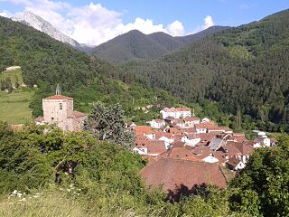
Isaba is a town and municipality located in the province and autonomous community of Navarre, northern Spain. Is the main town of the Roncal valley and is sited in the Pyrenees of the autonomous Region.

Afon Glaslyn is a river in Gwynedd, north-west Wales. While not of great significance in terms of its length, it is one of Gwynedd's primary rivers, and has greatly influenced the landscape in which it flows.
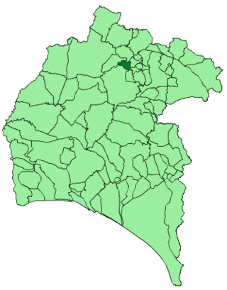
Jabugo is a town and municipality located in the province of Huelva, Spain. According to the 2005 census, it has a population of 2,475 inhabitants. The region is known for its signature ham, Jamón ibérico.

Császló is a village in Szabolcs-Szatmár-Bereg county, in the Northern Great Plain region of eastern Hungary.

Milles de la Polvorosa is a municipality located in the province of Zamora, Castile and León, Spain. According to the 2004 census (INE), the municipality has a population of 265 inhabitants.

The Afon Twymyn is a river in Powys, Mid Wales.
Vancouver River is located in the Sunshine Coast region of the South Coast of British Columbia, Canada, emptying into Prince of Wales Reach of lower Jervis Inlet at the former cannery town of Vancouver Bay and the bay of the same name. The river is approximately 21 km in length.
Kou is a village in the Tenkodogo Department of Boulgou Province in south-eastern Burkina Faso. As of 2005, the village has a population of 678.
Oniipa is a town in the Oshikoto Region of northern Namibia and the district capital of the Oniipa electoral constituency. It lies just outside Ondangwa.

Charnwood Lodge is a 134.2-hectare (332-acre) biological and geological Site of Special Scientific Interest in Charnwood Forest, east of Coalville in Leicestershire. It is a national nature reserve, and contains two Geological Conservation Review sites. It is managed by the Leicestershire and Rutland Wildlife Trust.
Sanningassoq Island is an island of Greenland. It is located in Baffin Bay in the Upernavik Archipelago.

Cynghordy is a village in the rural community of Llanfair-ar-y-bryn in Carmarthenshire, Wales. It lies on the A483 road northeast of the town of Llandovery, and is served by Cynghordy railway station on the Heart of Wales Line.
