McCurtain County is in the southeastern corner of the U.S. state of Oklahoma. As of the 2010 census, the population was 33,151. Its county seat is Idabel. It was formed at statehood from part of the earlier Choctaw Nation in Indian Territory. The name honors an influential Choctaw family that lived in the area. Green McCurtain was the last chief when Oklahoma became a state in 1907.
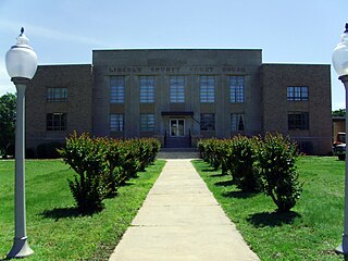
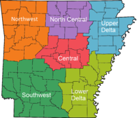
Lincoln County is located between the Arkansas Timberlands and Arkansas Delta in the U.S. state of Arkansas. It is also within the Pine Bluff metro area, and on the outer edge of the Central Arkansas region. The county is named for President Abraham Lincoln. Created as Arkansas's 65th county on March 28, 1871, Lincoln County has three incorporated cities, including Star City, the county seat and most populous city. The county contains 46 unincorporated communities and ghost towns, Cane Creek State Park at the confluence of Cane Creek and Bayou Bartholomew, and nine listings on the National Register of Historic Places to preserve the history and culture of the county.

Hot Spring County is located in the U.S. state of Arkansas. As of the 2010 census, the population was 32,923. The county seat is Malvern. Hot Spring County was formed on November 2, 1829, from a portion of Clark County. It was named for the hot springs at Hot Springs, Arkansas, which were within its boundaries until Garland County was formed in 1873. It is an alcohol prohibition or dry county. However, there is no record of this law.

Bradley County is a county located in the U.S. state of Arkansas. As of the 2020 census, the population was 10,545. The county seat is Warren. It is Arkansas's 43rd county, formed on December 18, 1840, and named for Captain Hugh Bradley, who fought in the War of 1812. It is an alcohol prohibition or dry county, and is the home of the Bradley County Pink Tomato Festival.

Ashley County is a rural South Arkansas county with a culture, economy, and history based on timber and agriculture. Created as Arkansas's 52nd county on November 30, 1848, Ashley County has seven incorporated municipalities, including Hamburg, the county seat and Crossett, the most populous city. The county is also the site of numerous unincorporated communities and ghost towns. The county is named for Chester Ashley, a prominent lawyer in the Arkansas Territory and U.S. senator from the state from 1844 to 1848.

Union Parish is a parish located in the north central section of the U.S. state of Louisiana. As of the 2010 census, the population was 22,721. The parish seat is Farmerville. The parish was created on March 13, 1839, from a section of Ouachita Parish. Its boundaries have changed four times since then.

The Ouachita Mountains, simply referred to as the Ouachitas, are a mountain range in western Arkansas and southeastern Oklahoma. They are formed by a thick succession of highly deformed Paleozoic strata constituting the Ouachita Fold and Thrust Belt, one of the important orogenic belts of North America. The Ouachitas continue in the subsurface to the northeast, where they make a poorly understood connection with the Appalachians and to the southwest, where they join with the Marathon uplift area of West Texas. Together with the Ozark Plateaus, the Ouachitas form the U.S. Interior Highlands. The highest natural point is Mount Magazine at 2,753 feet (839 m).

The Little Missouri River, or Little Mo, is a 147-mile-long (237 km) waterway that runs from the Ouachita Mountains of southwest Arkansas into the rolling hills area in the surrounding countryside.
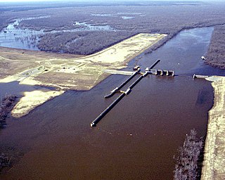
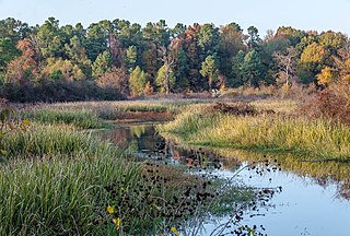
The Felsenthal National Wildlife Refuge (NWR) is a 76,000 acre national wildlife refuge located in south-central Arkansas in Ashley, Bradley, and Union counties. Felsenthal NWR is one of three refuges forming an administrative complex, which also includes Pond Creek NWR to the northwest and Overflow NWR to the east.

The University of Arkansas at Monticello (UAM) is a public university in Monticello, Arkansas with Colleges of Technology in Crossett and McGehee. UAM is part of the University of Arkansas System and offers master's degrees, baccalaureate degrees, and associate degrees. The city is in the Arkansas Timberlands, and UAM is home to the state's only School of Forest Resources.

South Arkansas lies within the southernmost portions of Arkansas Gulf Coastal Plain and Delta regions. It encompasses the lower 15 counties of the state.

Arkansas Highway 24 is the designation of two separate state highways in southwest and south central Arkansas. The two sections were formerly connected, but a middle segment of 53 miles (85 km) between Lockesburg and Prescott was redesignated as U.S. Route 371 in 1994.
Bayou Bartholomew is the longest bayou in the world, meandering approximately 364 miles (586 km) between the U.S. states of Arkansas and Louisiana. It contains over 100 aquatic species making it the second most diverse stream in North America. Known for its excellent bream, catfish, and crappie fishing, portions of the bayou are considered some of the best kept secrets of Arkansas anglers. It starts northwest of the city of Pine Bluff, Arkansas, in the Hardin community, winds through parts of Jefferson, Lincoln, Desha, Drew, Chicot, and Ashley counties in Arkansas, and Morehouse Parish, Louisiana, and eventually enters the Ouachita River after passing the northernmost tip of Ouachita Parish, near Sterlington, Louisiana. The bayou serves as the primary border separating the Arkansas Delta from the Arkansas Timberlands.

The Little River is a tributary of the Red River, with a total length of 217 miles (349 km), 130 miles (210 km) within the Choctaw Indian Reservation in southeastern Oklahoma and 87 miles (140 km) in southwestern Arkansas in the United States. Via the Red, it is part of the watershed of the Mississippi River. Six large reservoirs impound the Little River and its tributaries. The drainage basin of the river totals 4,204 square miles (10,890 km2), 2,204 square miles (5,710 km2) in Oklahoma and 2,036 square miles (5,270 km2) in Arkansas. The Little River and its upper tributaries are popular for recreational canoeing and kayaking.

The geography of Arkansas varies widely. The state is covered by mountains, river valleys, forests, lakes, and bayous in addition to the cities of Arkansas. Hot Springs National Park features bubbling springs of hot water, formerly sought across the country for their healing properties. Crowley's Ridge is a geological anomaly rising above the surrounding lowlands of the Mississippi embayment.

The Kiamichi Mountains are a mountain range in southeastern Oklahoma. A subrange within the larger Ouachita Mountains that extend from Oklahoma to western Arkansas, the Kiamichi Mountains sit within Le Flore, Pushmataha, and McCurtain counties near the towns of Poteau and Albion. The foothills of the Kiamichi Mountains sit within Haskell County, Northern Latimer County, and Northern Pittsburg County. Its peaks, which line up south of the Kiamichi River, reach 2,500 feet in elevation. The range was the namesake of Kiamichi Country, the official tourism designation for southeastern Oklahoma, until the designation was changed to Choctaw Country.
The Poison Springs State Forest encompasses 23,506 acres (9,513 ha) in Ouachita and Nevada counties in the U.S. state of Arkansas, and is under the authority of the Arkansas Forestry Commission (AFC). The name derives from the 1864 Battle of Poison Spring, so-called because of a legend about the poisoning of local water at the time of the battle. The actual battle site is preserved as Poison Springs Battleground State Park, located on 85 acres (34 ha) inside the forest.

The Arkansas Valley is a Level III ecoregion designated by the Environmental Protection Agency (EPA) in the U.S. states of Arkansas and Oklahoma. It parallels the Arkansas River between the flat plains of western Oklahoma and the Arkansas Delta, dividing the Ozarks and the Ouachita Mountains with the broad valleys created by the river's floodplain, occasionally interrupted by low hills, scattered ridges, and mountains. In Arkansas, the region is often known as the Arkansas River Valley, especially when describing the history and culture of the region.