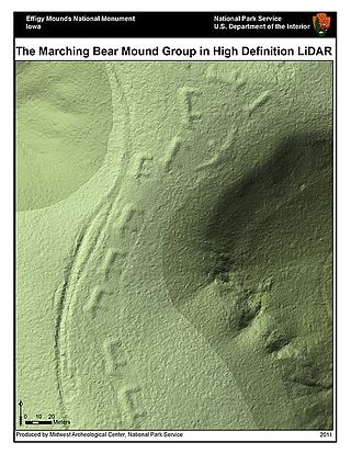
Lidar is a method for determining ranges by targeting an object or a surface with a laser and measuring the time for the reflected light to return to the receiver. LIDAR may operate in a fixed direction or it may scan multiple directions, in which case it is known as LIDAR scanning or 3D laser scanning, a special combination of 3-D scanning and laser scanning. LIDAR has terrestrial, airborne, and mobile applications.

A digital elevation model (DEM) or digital surface model (DSM) is a 3D computer graphics representation of elevation data to represent terrain or overlaying objects, commonly of a planet, moon, or asteroid. A "global DEM" refers to a discrete global grid. DEMs are used often in geographic information systems (GIS), and are the most common basis for digitally produced relief maps. A digital terrain model (DTM) represents specifically the ground surface while DEM and DSM may represent tree top canopy or building roofs.

The United States Army Corps of Engineers (USACE) is an engineer formation of the United States Army that has three primary mission areas: Engineer Regiment, military construction, and civil works. The day-to-day activities of the three mission areas are administered by a lieutenant general known as the commanding general/chief of engineers. The chief of engineers commands the Engineer Regiment, comprising combat engineer, rescue, construction, dive, and other specialty units, and answers directly to the Chief of Staff of the Army. Combat engineers, sometimes called sappers, form an integral part of the Army's combined arms team and are found in all Army service components: Regular Army, National Guard, and Army Reserve. Their duties are to breach obstacles; construct fighting positions, fixed/floating bridges, and obstacles and defensive positions; place and detonate explosives; conduct route clearance operations; emplace and detect landmines; and fight as provisional infantry when required. For the military construction mission, the commanding general is directed and supervised by the Assistant Secretary of the Army for installations, environment, and energy, whom the President appoints and the Senate confirms. Military construction relates to construction on military bases and worldwide installations.

The National Geospatial-Intelligence Agency (NGA) is a combat support agency within the United States Department of Defense whose primary mission is collecting, analyzing, and distributing geospatial intelligence (GEOINT) in support of national security. Initially known as the National Imagery and Mapping Agency (NIMA) from 1996 to 2003, it is a member of the United States Intelligence Community.

The National Reconnaissance Office (NRO) is a member of the United States Intelligence Community and an agency of the United States Department of Defense which designs, builds, launches, and operates the reconnaissance satellites of the U.S. federal government, and provides satellite intelligence to several government agencies, particularly signals intelligence (SIGINT) to the NSA, imagery intelligence (IMINT) to the NGA, and measurement and signature intelligence (MASINT) to the DIA.

ISTAR stands for intelligence, surveillance, target acquisition, and reconnaissance. In its macroscopic sense, ISTAR is a practice that links several battlefield functions together to assist a combat force in employing its sensors and managing the information they gather.

The Engineer Research and Development Center (ERDC) is a US Army Corps of Engineers (USACE) research and laboratory organization. The headquarters is located in Vicksburg, Mississippi, on the site of an antecedent organization, the Waterways Experiment Station.
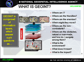
In the United States, geospatial intelligence (GEOINT) is intelligence about the human activity on earth derived from the exploitation and analysis of imagery, signals, or signatures with geospatial information. GEOINT describes, assesses, and visually depicts physical features and geographically referenced activities on the Earth. GEOINT, as defined in US Code, consists of imagery, imagery intelligence (IMINT) and geospatial information.

The Vector Map (VMAP), also called Vector Smart Map, is a vector-based collection of geographic information system (GIS) data about Earth at various levels of detail. Level 0 (low resolution) coverage is global and entirely in the public domain. Level 1 (global coverage at medium resolution) is only partly in the public domain.

GeoPDF refers to map and imagery products created by TerraGo software applications. GeoPDF products use geospatial PDF as a container for maps, imagery, and other data used to deliver an enhanced user experience in TerraGo applications. However, GeoPDF products conform to published specifications including both the OGC best practice for PDF georegistration as well as Adobe's proposed geospatial extensions to ISO 32000, making them readable by applications such as Adobe Acrobat, Adobe Reader, Avenza PDF Maps, Global Mapper, and others. GeoPDF products often include other advanced PDF features such as layers and object data which can add significant GIS functionality to the file, particularly when used with the TerraGo Technologies plugin to Adobe Reader or other TerraGo clients.

The Remote Sensing Center (RSC) at the Naval Postgraduate School was established to bring together a range of capabilities and expertise to address problems of military and intelligence importance, as well as environmental and civil concerns. It is specialized in a variety of remote sensing technologies designed to enable people to look beyond the range of human vision in range or in spectral perception.
Currently, the best source for nationwide LiDAR availability from public sources is the United States Interagency Elevation Inventory (USIEI). The USIEI is a collaborative effort of NOAA and the U.S. Geological Survey, with contributions from the Federal Emergency Management Agency, the Natural Resources Conservation Service, the US Army Corps of Engineers, and the National Park Service. The inventory displays high-accuracy topographic and bathymetric data for the US, and it's intended to be a comprehensive, nationwide listing of known high-accuracy topographic data, including lidar. The inventory is updated semi-annually. Note, however, that getting access to the data is often less than straightforward in the current implementation.
Geographic information systems (GIS) play a constantly evolving role in geospatial intelligence (GEOINT) and United States national security. These technologies allow a user to efficiently manage, analyze, and produce geospatial data, to combine GEOINT with other forms of intelligence collection, and to perform highly developed analysis and visual production of geospatial data. Therefore, GIS produces up-to-date and more reliable GEOINT to reduce uncertainty for a decisionmaker. Since GIS programs are Web-enabled, a user can constantly work with a decision maker to solve their GEOINT and national security related problems from anywhere in the world. There are many types of GIS software used in GEOINT and national security, such as Google Earth, ERDAS IMAGINE, GeoNetwork opensource, and Esri ArcGIS.

The Army Map Service (AMS) was the military cartographic agency of the United States Department of Defense from 1941 to 1968, subordinated to the United States Army Corps of Engineers. On September 1, 1968, the AMS was redesignated the U.S. Army Topographic Command (USATC) and continued as an independent organization until January 1, 1972, when it was merged into the new Defense Mapping Agency (DMA) and redesignated as the DMA Topographic Center (DMATC). On October 1, 1996, DMA was folded into the National Imagery and Mapping Agency (NIMA), which was redesignated as the National Geospatial-Intelligence Agency (NGA) in 2003.
TerraGo is a private company based in Sterling, Virginia with offices in Atlanta, Georgia, and the UK that develops location intelligence, geospatial collaboration, GIS applications, GPS data collection software. Founded in 2005, TerraGo is an In-Q-Tel portfolio company. In 2012, TerraGo acquired fellow In-Q-Tel portfolio company Geosemble. Aside from being an In-Q-Tel portfolio company, TerraGo is notable in part for pioneering the patented technology, related standards and best practices upon which GeoPDF and geospatial PDF are based and programs related thereto.
Aquaveo is a modeling software company based in Provo, Utah that develops software used to model and simulate groundwater, watershed, and surface water resources. Its main software products include SMS, GMS, WMS, and Arc Hydro Groundwater.
The Geospatial Research Laboratory is a component of the Engineer Research and Development Center (ERDC), a US Army Corps of Engineers (USACE) laboratory organization whose mission is to "Provide science, technology, and expertise in engineering and environmental sciences in support of our Armed Forces and the Nation to make the world safer and better." The laboratory is colocated with the Army Geospatial Center in the Humphreys Engineer Center adjacent to Fort Belvoir. The headquarters is located in Vicksburg, Mississippi, on the site of an antecedent organization, the Waterways Experiment Station. GRL conducts geospatial research, development, technology and evaluation of current and emerging geospatial technologies that will help characterize and measure phenomena within the physical (terrain) and social (cultural) environments encountered by the Army. GRL research areas and capabilities include terrain analysis and reasoning; passive and active spectral signature analysis; fluorescence; photogrammetry; terrain visualization; precision surveying and mapping; image analysis; data management; geographic information systems; data/image fusion; and spatio-temporal reasoning and numerical analysis.
The Buckeye system is an operational airborne surveying system that provides high-resolution spatial imagery over an area of interest to support military operations involved with intelligence, surveillance, and reconnaissance. Once mounted on a helicopter or an unmanned aerial vehicle (UAV), it incorporates visual information from a digital camera and elevation data from a Light Detection and Ranging (LIDAR) system to create a two and three-dimensional colored map with orthorectified, 4 to 6-inch resolution.
The United States Army Geospatial Intelligence Battalion, previously known as the 3rd Military Intelligence Center, is a military intelligence battalion specializing in the production and exploitation of geospatial intelligence (GEOINT), and the only operational military command at the National Geospatial-Intelligence Agency (NGA). Co-located within the NGA headquarters (NGA-East) on Fort Belvoir in Springfield, Virginia, the unit produces and analyzes geospatial intelligence products for ground combat forces in close collaboration with its host agency and other members of the U.S. Intelligence Community. Though colocated with NGA, the AGB differs from NGA's own Support Teams in that it receives tasking from the Army.