Arroscia

Last updated
Arroscia
Arroscia-IMG 0829.JPG
Arroscia map.png
Location
Country Italy
Physical characteristics
Source 
  locationnear Mendatica
Mouth Centa
  coordinates
44°03′13″N8°11′15″E / 44.05361°N 8.18750°E / 44.05361; 8.18750
  elevation
5 m (16 ft) [1]
Length36.5 [2]
Basin size289 km2 (112 sq mi)
Discharge 
  average4.02 m3/s (142 cu ft/s) [3]
Basin features
Progression CentaLigurian Sea

The Arroscia is an Italian river in the provinces of Imperia. [4] and Savona.

Contents

Geography

The river rises from monte Frontè, in the comune of Mendatica, not far from the French border. The Arroscia flows east and receives several tributaries. It then joins the Neva and forms with it the Centa, one of the most relevant rivers of western Liguria. The Arroscia has a basin of 289 km2 (112 sq mi). [5]

Main tributaries

Lerrone confluence, with the A10 motorway in the background Confluenza arroscia lerrone.jpg
Lerrone confluence, with the A10 motorway in the background

Related Research Articles

Scrivia river in Italy

The Scrivia, 117 kilometres (73 mi) long, is a right tributary of the river Po, in northern Italy. It runs through Liguria, Piedmont, and Lombardy.

Argentina (river) river in Italy

The Argentina is an Italian river in the province of Imperia.

Nervia river in Italy

The Nervia is a 28.3-kilometre (17.6 mi) stream of Liguria (Italy).

Centa (river) river in Italy

The Centa is a very short Italian river in the province of Savona.

Entella (river) river in Italy

The Entella is a very short river within the Metropolitan City of Genoa in the Liguria region of northwestern Italy.

Pora (river) river in Italy

The Pora is a 15-kilometre (9.3 mi) stream of Liguria (Italy).

Bergeggi (island) island

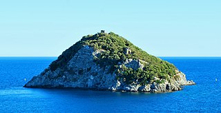
Bergeggi is an island which lies in the Ligurian Sea off the coast near the village of Bergeggi in the Province of Savona, Liguria, Italy.

Varatella river in Italy

The Varatella is a 7-kilometre (4.3 mi) stream of Liguria (Italy).

Bisagno (river) river in Liguria, Italy

The Bisagno is a 25-kilometre (16 mi) river in Liguria, (Italy).

Stura di Ovada river in Italy

The Stura di Ovada is a 32.9-kilometre (20.4 mi) stream of Liguria and Piedmont (Italy); it is the main tributary of the Orba.

Rocca Barbena Mountain in Italy

Rocca Barbena is a 1,142-metre (3,747 ft) high mountain in the Ligurian Prealps in Italy.

Steria (creek) stream in Liguria, Italy

The Steria or Cervo is a 9.6-kilometre (6.0 mi) stream of Liguria (Italy).

Impero (river)

The Impero is a 22.4-kilometre (13.9 mi) stream of Liguria (Italy).

San Pietro (creek) Stream in Liguria, Italy

The San Pietro or Evigno is a 10.2-kilometre (6.3 mi) stream of Liguria (Italy).

Merula (creek) creek, Italy

The Merula is a 14.7-kilometre (9.1 mi) stream of Liguria (Italy).

Neva (Italy) river in Italy

The Neva is a 22-kilometre (14 mi) torrent or stream of Piemonte and Liguria (Italy).

Giara di Rezzo

The Giara di Rezzo is a 14-kilometre (8.7 mi) stream of Liguria, Italy.

Monte Monega Mountain in Italy

Monte Monega is a 1,882-metre (6,175 ft) mountain of the Ligurian Alps, in Italy.

Carmo di Brocchi Mountain in Italy

Carmo di Brocchi is a 1,610-metre (5,282 ft) mountain of the Ligurian Alps, in Italy.

Brevenna

The Brevenna is a 16.138-kilometre (10.028 mi) creek of Liguria, Italy.

References

  1. "Carta tecnica regionale su Limiti Amministrativi (Comunali, Provinciali, Regionali) sc. 1:25000". geoportale.regione.liguria.it. Regione Liguria. 2011.
  2. Ferro, Gaetano (1961). "Principali corsi d'acqua della Liguria". Liguria (in Italian). Pironti. p. 28. Retrieved 2017-07-27.
  3. Portate (mc) ARROSCIA (Centa) a Pogli, 1961-1970 data of Agenzia per la protezione dell'ambiente e per i servizi tecnici; on-line version: "Archived copy". Archived from the original on 2015-07-08. Retrieved 2015-11-05.CS1 maint: archived copy as title (link) (access: 5 November 2015)
  4. The Times (1985), Atlas of the World: Comprehensive Edition, Times Books, Plate 78 (D6)
  5. PIANO DI BACINO STRALCIO SUL RISCHIO IDROGEOLOGICO (PDF). Provincia di Savona. 2003. p. 58. Archived from the original (PDF) on 2017-07-29. Retrieved 2017-07-22.

See also

Commons-logo.svg Media related to Arroscia at Wikimedia Commons

Coordinates: 44°03′N8°11′E / 44.050°N 8.183°E / 44.050; 8.183