Arshty

Last updated
Arshty
Аршты
Other transcription(s)
  IngushАьрште [lower-alpha 1]
Location of Arshty
Arshty
Russia administrative location map.svg
Red pog.svg
Arshty
Location of Arshty
Outline Map of Ingushetia.svg
Red pog.svg
Arshty
Arshty (Republic of Ingushetia)
Coordinates: 43°08′21″N45°07′46″E / 43.13917°N 45.12944°E / 43.13917; 45.12944
Country Russia
Federal subject Ingushetia
Founded1705
Population
  Total1,347
  Estimate 
(2021) [6]
1,473
  Subordinated to Sunzhensky District
Time zone UTC+3 (MSK   OOjs UI icon edit-ltr-progressive.svg [7] )
Postal code(s) [8]
386247
OKTMO ID26610440101

Arshty [lower-alpha 2] is a rural locality (a selo ) in Sunzhensky District of the Republic of Ingushetia, Russia, located on left bank of the river Arshtynka near the border with the Republic of Chechnya. It forms the municipality of the rural settlement of Arshty as the only settlement in its composition. [9] [10]

Contents

Geography

The village of Arshty on the map of the Ingush district in 1853. Ingushskii okrug na Dorozhnoi karte Kavkazskogo kraia 1853 g. (186(4).jpg
The village of Arshty on the map of the Ingush district in 1853.
The village of Arshty on the map of the Ingush district in 1869. Ingushskii okrug na karte Kavkazskogo kraia (1869 g.).jpg
The village of Arshty on the map of the Ingush district in 1869.
The village Arshty on the map of Sunzhensky (Ingush) otdel in 1892 Karta Terskoi Oblasti, 1892 g. (Sunzhenskii otdel).jpg
The village Arshty on the map of Sunzhensky (Ingush) otdel in 1892

The village is located on the left bank of the Arshtynka River, just above its confluence with Faetonka, 20 km south of the regional center - the city of Sunzha and 26 km east of the capital of the republic - the city of Magas.

The nearest settlements are: in the north - the village of Chemulga, in the northeast - the village of Bamut and in the southwest - Akati farm.

History

In the second half of the 18th century (1770s), the German researcher J. A. Güldenstädt indicates Arshty and some other Orstkhoy villages among the total number of Ingush villages and districts proper. [11]

In the winter of 1825, Cossack and Chechen militsiya under the leadership of General Nikolai Grekov  [ ru ] made a punitive expedition to Arshty and devastated it. [12] During the Caucasian War, starting from 1840, the village was the center of the Vilayet Arshtkhoy, an administrative unit of the Caucasian Imamate.

Since 1861, Arshty has been in the Ingushskiy Okrug of the Terek Oblast. In 1859, caucasologist and military-historian Adolf Berge in his principal work Chechenya and Chechens mentioned Arshty among the Galashian villages. [13] As a result of the eviction of the Orstkhoys to Turkey in 1865, including to the village of Arshty, an intensive resettlement of the Malkhists and Maystins began. [14] Since 1924, the village of Arshty, together with neighboring Bamut, was part of Ingush Autonomous Oblast. According to the Soviet Census in 1926, upper Arshty had population of 303, 303 people of Ingush ethnicity. Lower Arshty had population of 550, 546 people of Ingush ethnicity. [15]

In 1944, after the Deportation of Chechens and Ingush and the abolition of the Chechen-Ingush Autonomous Soviet Socialist Republic, the village of Arshty was renamed Dubravino. [16]

After the restoration of the Chechen-Ingush Autonomous Soviet Socialist Republic, in 1958 the settlement was returned to its former name - Arshty.

During the First Chechen war on February 22, 1996, the village was shelled by Russian troops by mistake, as the Russian soldiers had a misconception that Chechen rebels were hiding in Arshty. This incident killed ten people, mostly women. [17]

Notes

  1. 1 2 Commonly mentioned as Ärshte (Ingush: Аьрште), [1] [2] however the village was sometimes mentioned as Arshte (Арште) [3] or Ērshte (Эрште). [4]
  2. Russian: Аршты; Ingush: Аьрште, romanized: Äršte, lit. 'On the plain'; [lower-alpha 1] Chechen: Аьршта, romanized: Äršta

    Related Research Articles

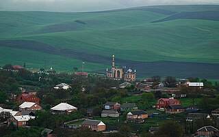
    Sagopshi is a rural locality in Malgobeksky District of the Republic of Ingushetia, Russia. Population: 10,048 (2010 Russian census); 10,738 (2002 Census).

    <span class="mw-page-title-main">Orstkhoy</span> Historical ethnoterritorial society among the Ingush and Chechen people

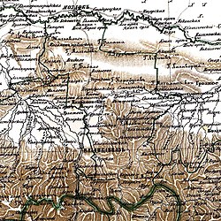
    The Orstkhoy, historically commonly known under their exonyms: Karabulaks, Balsu, Baloy, are a historical ethnoterritorial society among the Chechen and Ingush peoples. Their homeland is in the upper reaches of the Assa and Fortanga rivers in the historical region of Orstkhoy-Mokhk. In the tradition of the Chechen ethno-hierarchy, it is considered one of the nine historical Chechen tukkhums, in the Ingush tradition as one of the seven historical Ingush shahars.

    Galashki is a rural locality in Sunzhensky District of the Republic of Ingushetia, Russia, located on the left bank of the Sunzha River near the border with the Republic of North Ossetia–Alania. Its population was about 9,000 people in 2009. Galashki forms the municipality of the rural settlement of Galashki as the only settlement in its composition.

    Bamut is a non-residential rural locality in Sernovodsky District of the Republic of Chechnya, Russia. From 1922 to 1934, Bamut was a part of the Ingush Autonomous Oblast.

    <span class="mw-page-title-main">Act of oath of six Ingush clans to Russia</span> Treaty between six Ingush clans and Russia

    The Act of oath of six Ingush clans to Russia was a treaty between ten representatives of six major Ingush clans (teips) and the Russian Empire. It was signed on August 22, 1810 in the city of Vladikavkaz. Due to this oath, the Ingush were given the right to settle the land along the right bank of the Terek up to the ridge.

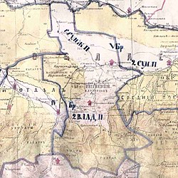
    Ingush societies or shahars were ethnoterritorial associations of the Ingush based on the geographical association of several villages and intended for conditional administrative-territorial delimitation of the Ingush ethnic group. The formation and functioning of most of them dates back to the late Middle Ages. During this period, their boundaries, number and names changed.

    Tyarsh or Tarsh, is an aul in the Dzheyrakhsky District of Ingushetia. It is part of the rural settlement of Olgeti. Tyarsh is the ancestral aul of Ingush teip Torshkhoy.

    Muzhichi is a rural locality in Sunzhensky District of the Republic of Ingushetia, Russia, located on the left bank of the Sunzha River near the border with the Republic of North Ossetia–Alania. It forms the municipality of the rural settlement of Muzhichi as the only settlement in its composition.

    <span class="mw-page-title-main">Yandare</span> Rural locality in Ingushetia

    Yandare is a rural locality in Nazranovsky District of the Republic of Ingushetia, Russia. It forms the municipality of the rural settlement of Yandare as the only settlement in its composition.

    <span class="mw-page-title-main">Ekazhevo</span> Rural locality in Ingushetia

    Ekazhevo is a rural locality in Nazranovsky District of the Republic of Ingushetia, Russia. It forms the municipality of the rural settlement of Ekazhevo as the only settlement in its composition.

    <span class="mw-page-title-main">Barsuki, Ingushetia</span> Rural locality in Ingushetia

    Barsuki is a rural locality in Nazranovsky District of the Republic of Ingushetia, Russia. It forms the municipality of the rural settlement of Barsuki as the only settlement in its composition.

    <span class="mw-page-title-main">Plievo</span> Rural locality in Ingushetia

    Plievo is a rural locality in Nazranovsky District of the Republic of Ingushetia, Russia. It forms the municipality of the rural settlement of Plievo as the only settlement in its composition.

    <span class="mw-page-title-main">Surkhakhi</span> Rural locality in Ingushetia

    Surkhakhi is a rural locality in Nazranovsky District of the Republic of Ingushetia, Russia. It forms the municipality of the rural settlement of Surkhakhi as the only settlement in its composition.

    Dattykh is a rural locality in Sunzhensky District of the Republic of Ingushetia, Russia, located on the left bank of the river Fortanga. It forms the municipality of the rural settlement of Dattykh as the only settlement in its composition.

    <span class="mw-page-title-main">Fortanga</span> River in Ingushetia, Russia

    Fortanga historically sometimes referred as Balsu, is a river in North Caucasus that flows in Ingushetia and Chechnya. The length of the river is 69 km, the basin area is 526 km2.

    <span class="mw-page-title-main">Vilayet Arshtkhoy</span> Administrative unit of the Caucasian Imamate

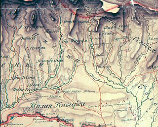
    Vilayet Arshtkhoy,Vilayet Arshty,Arshtinskiy Vilayet, was an Ingush administrative unit of the North Caucasian Imamate. The Naibstvo was the farthest region of the Imamate in the west and it was established on the territory of Orstkhoy society with the center being the village of Arshty.

    Psedakh is a rural locality in the Malgobeksky District of the Republic of Ingushetia, Russia. It forms the municipality of the rural settlement of Psedakh as the only settlement in its composition.

    <span class="mw-page-title-main">Targim</span> Rural locality in Ingushetia

    Targim is an ancient city-settlement in the Dzheyrakhsky District of Ingushetia. It is part of the rural settlement of Guli. The entire territory of the settlement is included in the Dzheyrakh-Assa State Historical-Architectural and Natural Museum-Reserve and is under state protection.

    <span class="mw-page-title-main">Metskhal</span> Rural locality in Ingushetia

    Metskhal is an abandoned aul in the Dzheyrakhsky District of Ingushetia. It is part of the rural settlement of Lyazhgi.

    Gandalbos is rural locality in Sunzhensky District of the Republic of Ingushetia, Russia, located on the left bank of the river Fortanga. It is part of the municipality of the rural settlement of Dattykh.

    References

    1. Оздоев 1980, p. 830.
    2. Кодзоев 2021, p. 14.
    3. Мальсагов 1963, p. 142.
    4. Барахоева, Кодзоев & Хайров 2016, p. 30.
    5. Russian Federal State Statistics Service (2011). Всероссийская перепись населения 2010 года. Том 1 [2010 All-Russian Population Census, vol. 1]. Всероссийская перепись населения 2010 года [2010 All-Russia Population Census] (in Russian). Federal State Statistics Service.
    6. "Таблица 5. Численность населения России, федеральных округов, субъектов Российской Федерации, городских округов, муниципальных районов, муниципальных округов, городских и сельских поселений, городских населенных пунктов, сельских населенных пунктов с населением 3000 человек и более". Всероссийской переписи населения 2020 года [ permanent dead link ]
    7. "Об исчислении времени". Официальный интернет-портал правовой информации (in Russian). 3 June 2011. Retrieved 19 January 2019.
    8. Почта России. Информационно-вычислительный центр ОАСУ РПО. (Russian Post). Поиск объектов почтовой связи (Postal Objects Search) (in Russian)
    9. "Закон Республики Ингушетия от 23 февраля 2009 года № 5-рз «Об установлении границ муниципальных образований Республики Ингушетия и наделении их статусом сельского поселения, муниципального района и городского округа»".
    10. "Код ОКАТО 26 230 808 000 — Арштынская сельский округ (сельсовет)* (Сунженский район)". Archived from the original on 2018-02-28.www.ocato.ru.
    11. Гюльденштедт 2002, p. 242.
    12. Доклад о границах и территории Ингушетии 2021, pp. 48, 84–85.
    13. Берже 1859, p. 117.
    14. Волкова 1974, p. 238.
    15. "Поселенные итоги переписи 1926 г. по Северо-Кавказскому краю" (in Russian). Ростов-на-Дону. 1929. p. 405.
    16. Указ Президиума Верховного Совета РСФСР о переименовании некоторых сельских советов и населённых пунктов Грозненской области (см. документ No.100)
    17. Kamyshev 1996.

    Bibliography

    Russian sources