Ku-ring-gai Chase National Park is a national park on the northern side of Sydney in New South Wales, Australia. The 14,977-hectare (37,010-acre) park is 25 kilometres (16 mi) north of the Sydney central business district and generally comprises the land east of the M1 Pacific Motorway, south of the Hawkesbury River, west of Pittwater and north of Mona Vale Road. It includes Barrenjoey Headland on the eastern side of Pittwater.
The Sydney Basin is an interim Australian bioregion and is both a structural entity and a depositional area, now preserved on the east coast of New South Wales, Australia and with some of its eastern side now subsided beneath the Tasman Sea. The basin is named for the city of Sydney, on which it is centred.
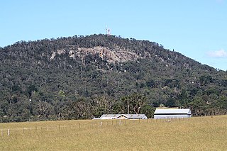
Mount Gibraltar is a mountain with an elevation of 863 metres (2,831 ft) AHD that is located in the Southern Highlands region, between Bowral and Mittagong, in New South Wales, Australia. Further west is Berrima.

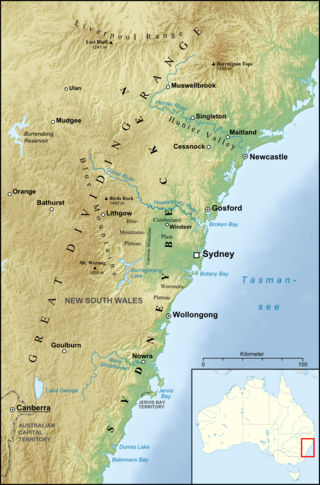
The geography of Sydney is characterised by its coastal location on a basin bordered by the Pacific Ocean to the east, the Blue Mountains to the west, the Hawkesbury River to the north and the Woronora Plateau to the south. Sydney lies on a submergent coastline on the east coast of New South Wales, where the ocean level has risen to flood deep river valleys (rias) carved in the Sydney sandstone. Port Jackson, better known as Sydney Harbour, is one such ria.

Sydney sandstone, also known as the Hawkesbury sandstone, yellowblock, and yellow gold, is a sedimentary rock named after Sydney, and the Hawkesbury River north of Sydney, where this sandstone is particularly common.

The Cumberland Plain, also known as Cumberland Basin, is a relatively flat region lying to the west of Sydney CBD in New South Wales, Australia. An IBRA biogeographic region, Cumberland Basin is the preferred physiographic and geological term for the low-lying plain of the Permian-Triassic Sydney Basin found between Sydney and the Blue Mountains, and it is a structural sub-basin of the Sydney Basin.

The Sydney Turpentine-Ironbark Forest (STIF) is a wet sclerophyll forest community of Sydney, New South Wales, Australia, that is typically found in the Inner West and Northern region of Sydney. It is also among the three of these plant communities which have been classified as Endangered, under the New South Wales government's Threatened Species Conservation Act 1995, with only around 0.5% of its original pre-settlement range remaining.

The Wianamatta Group is a geological feature of the Sydney Basin, New South Wales, Australia that directly overlies the older Hawkesbury sandstone and generally comprise fine grained sedimentary rocks such as shales and laminites as well as less common sandstone units.
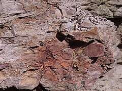
Notobrachyops is a genus of brachyopid temnospondyl amphibian. It is known from a skull roof impression found in the Ashfield Shale of Mortdale, New South Wales, Australia. The Ashfield Shale has also yielded a shark species, a lungfish species, six species of paleoniscid fish, a species of holostean fish, a subholostean fish, and the labyrinthodont amphibian Paracyclotosaurus davidi.

The Narrabeen group of sedimentary rocks occurs in the Sydney Basin in eastern Australia. This series of rocks was formed in the Triassic Period.
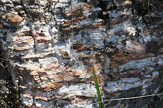
The Mittagong Formation is a sedimentary rock unit in the Sydney Basin in eastern Australia.

Lane Cove Bushland Park is located in suburban Lane Cove, 5 kilometres from the centre of Sydney, Australia. It is regarded as one of the more interesting areas of fungi in the country. In the year 2000, Bushland Park was placed on the Register of the National Estate, under the Australian Heritage Commission Act, 1975. Average annual rainfall is 1220 mm. Soils are moderately fertile, based on Hawkesbury sandstone and Ashfield Shale. The climate is warm and humid.

The Blue Gum High Forest of the Sydney Basin Bioregion is a wet sclerophyll forest found in the northern parts of Sydney, New South Wales, Australia. It has been classified as critically endangered, under the New South Wales government's Threatened Species Conservation Act 1995. The principal canopy trees in this forest community are Sydney blue gum and blackbutt which are usually seen between 20 and 40 metres tall. 180 species of indigenous plants have been identified at Dalrymple-Hay Nature Reserve.

Bringelly Shale is a component of the Wianamatta group of sedimentary rocks in the Sydney Basin of eastern Australia. Formed in the Triassic Period, it has an extensive outcrop in the western parts of Sydney. The shale has its greatest geographical extent at Bringelly, near the suburb of Liverpool.

Minchinbury Sandstone is a component of the Wianammatta Group of sedimentary rocks in the Sydney Basin of eastern Australia.

The Southern Sydney sheltered forest, or the Sydney Sandstone Gully Forest (SSGF), is a vegetation community found in Sydney, Australia that comprises an open forest composition grading into woodland or scrub, typically within gullies. The community is normally associated with sheltered heads and upper inclines of gullies on transitional zones where sandstone outcropping may be present.

The Hornsby Plateau is a dissected sandstone plateau lying to the north of Sydney Harbour that rises 200 metres. The plateau is a part of the larger Sydney Basin structure.

The ecology of Sydney, located in the state of New South Wales, Australia, is diverse for its size, where it would mainly feature biomes such as grassy woodlands or savannas and some sclerophyll forests, with some pockets of mallee shrublands, riparian forests, heathlands, and wetlands, in addition to small temperate rainforest fragments.

Wallumatta Nature Reserve, also called the Macquarie Hospital Bushland, is a 6-hectare (15-acre) nature reserve bushland area, surrounded by the residential suburb of East Ryde, in suburban Sydney, Australia. Once part of the Field of Mars of 1804, the reserve is the largest surviving area of Sydney Turpentine-Ironbark Forest, an endangered ecosystem. Soils are based on Ashfield Shale and Hawkesbury Sandstone.

Fiddens Wharf or Killara Wharf was a former wharf on the Lane Cove River in Sydney, Australia. Named after the convict Joseph Fidden, the wharf was primarily used for the transport of timber and supplies to and from Sydney in the 19th century. It is unknown whether the original structure was a conventional wharf, or a mooring place with lines connected to a metal ring secured in a nearby rock. Fiddens was one of the three main wharves on the river.