Related Research Articles

Aspley is a suburb in the City of Brisbane, Queensland, Australia. In the 2016 census, Aspley had a population of 12,108 people.

Mid Bedfordshire is a constituency represented in the House of Commons of the UK Parliament since 2005 by Nadine Dorries, of the Conservative Party. Apart from four early years, the constituency has returned a Conservative since its creation in 1918.

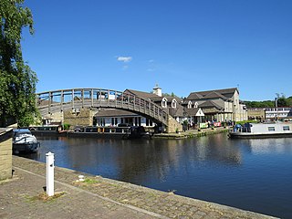
Aspley Guise is a village and civil parish in the west of Central Bedfordshire, England. In addition to the village of Aspley Guise itself, the civil parish also includes part of the town of Woburn Sands, the rest of which is in the City of Milton Keynes in Buckinghamshire. Together with Woburn Sands and Aspley Heath, it forms part of the Milton Keynes urban area. It is centred 6 miles (9.7 km) east southeast of Central Milton Keynes and 1 mile (1.6 km) south of the M1 junction 13. It has its own railway station on the Marston Vale Line, and an historic centre with 29 listed buildings.

Wolverton railway station serves the town of Wolverton in Milton Keynes, Buckinghamshire, England. The station is on the West Coast Main Line, about 52 miles (84 km) from Euston, between Milton Keynes Central and Northampton. The station is one of the seven stations serving the Milton Keynes urban area.

Shillington is a village and civil parish in Bedfordshire, England. In the south of the parish the hamlet of Pegsdon includes the Pegsdon hills nature reserve and is a salient of the county into Hertfordshire. Since 1985 its administration has included the village of Higham Gobion, south-west on the minor road leading to the main north–south road in the district, the A6. It has a population of 1,831 and is centred midway between stopping services railway stations on the Midland Main Line and East Coast Main Line 6 miles (9.7 km) away. Farmland and hedgerows forms 95% of the land use and to the south and north of the boundaries is intermittent woodland.

Ampthill was a rural district in Bedfordshire, England from 1894 to 1974. It entirely surrounded but did not include the urban district of Ampthill.

Coade stone or Lithodipyra or Lithodipra was stoneware that was often described as an artificial stone in the late 18th and early 19th centuries. It was used for moulding neoclassical statues, architectural decorations and garden ornaments of the highest quality that remain virtually weatherproof today.

Turnbridge is the area to the east of Huddersfield town centre ring road in West Yorkshire, England. It forms a corridor along which passes St Andrews Road, (B6432), and the Huddersfield Broad Canal to Aspley, where the Broad Canal meets Huddersfield Narrow Canal in the Aspley Basin. There are places for a limited number of narrowboat moorings. Some have electric and fresh water services.
Aspley is an area adjacent to the ring road around Huddersfield, Kirklees, West Yorkshire, England. It comprises a mixture of independent shops, commercial units, a small retail park, houses, student accommodation and sections of the University of Huddersfield and Kirklees Council offices, pubs and fast food outlets. It is known locally as Aspley Wharf.
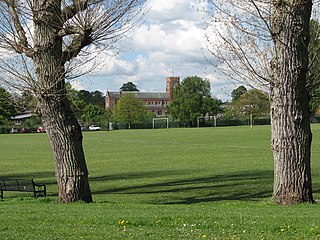
Melbourne Park is a large public space in Aspley, Nottingham, England. The park is approximately 500 by 600 metres. In addition to public greenspace, the site has a number of football pitches which are used for Sunday league football matches. There are many football teams around this area.

St. Margaret's Church, Aspley is a parish church in the Church of England in Aspley, Nottingham.

The Milton Keynes urban area or Milton Keynes Built-up Area is a designation established by the United Kingdom's Office for National Statistics. Milton Keynes has no statutory boundary: the 1967 designated area only determined the area assigned to the Milton Keynes Development Corporation for development. The wider urban area outside that designation includes Newport Pagnell and Woburn Sands as well as Aspley Guise (Bedfordshire) and part of Stoke Hammond civil parish.

Boston Friary refers to any one of four friaries that existed in Boston, Lincolnshire, England.

Moseley Hall is a Grade II listed 18th-century country house which was situated in parkland in Moseley, Birmingham. The hall itself is now part of Moseley Hall Hospital and much of the surrounding estate has been developed for roads and housing.
The Hare and Hounds is a Young's public house at Upper Richmond Road, East Sheen, in the London Borough of Richmond upon Thames. It is Grade II listed. A former coaching inn, it was built by an unknown architect in the early 19th century. It has a 1930s interior and an extensive garden.

Redlands is a Grade II listed country house estate in West Wittering, West Sussex, owned by The Rolling Stones' Keith Richards.

The Antelope, now housing a restaurant called Hajee's Spices, is a grade II listed building on the Stratford Road in Sparkhill, Birmingham, England. It opened as a public house called The Antelope in 1924.
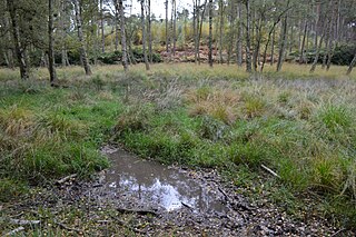
Wavendon Heath Ponds is a 4.7-hectare (12-acre) biological Site of Special Scientific Interest in Aspley Heath in Bedfordshire. It was notified in 1986 under Section 28 of the Wildlife and Countryside Act 1981, and the local planning authority is Central Bedfordshire Council.

The Hare and Hounds is a public house at 104 Sopwell Lane in St Albans, Hertfordshire, England. The timber framed building has a plastered exterior. It is listed Grade II with Historic England and is dated "seventeenth century or earlier".
The Vineyard is a street in Richmond, in the London Borough of Richmond upon Thames. It includes three groups of almshouses, a Grade II listed church and Clarence House, a 17th-century Grade II listed house associated with Bernardo O’Higgins, who is commemorated on the wall of the property with a blue plaque, installed by English Heritage, for his role in the Chilean War of Independence.
References
- ↑ Historic England. "Aspley House (1113948)". National Heritage List for England . Retrieved 9 November 2020.
- ↑ "Aspley House". bedsarchives.bedford.gov.uk. 20 June 2019. Retrieved 3 October 2020.
Coordinates: 52°00′55″N0°37′35″W / 52.01527°N 0.62633°W
| | This Bedfordshire location article is a stub. You can help Wikipedia by expanding it. |