
Longdendale is a valley in the Peak District of England, north of Glossop and southwest of Holmfirth. The name means "long wooded valley" and the valley is mostly in the counties of Derbyshire and Greater Manchester.

The Metropolitan Borough of Tameside is a metropolitan borough of Greater Manchester in England. It is named after the River Tame, which flows through the borough, and covers the towns of Ashton-under-Lyne, Audenshaw, Denton, Droylsden, Dukinfield, Hyde, Mossley and Stalybridge. Tameside is bordered by the metropolitan boroughs of Stockport to the south, Oldham to the north and northeast, Manchester to the west, and to the east by the Borough of High Peak in Derbyshire. As of 2011 the overall population was 219,324. It is also the 8th-most populous borough of Greater Manchester by population.

The River Etherow is a river in northern England, and a tributary of the River Goyt. Although now passing through South Yorkshire, Derbyshire and Greater Manchester, it historically formed the ancient county boundary between Cheshire and Derbyshire. The upper valley is known as Longdendale. The river has a watershed of approximately 30 square miles (78 km2), and the area an annual rainfall of 52.5 inches (1,330 mm).

Stalybridge is a town in Tameside, Greater Manchester, England, with a population of 23,731 at the 2011 Census.
Denton is a town in Tameside, Greater Manchester, England, five miles (8 km) east of Manchester city centre. Historically part of Lancashire, it had a population of 36,591 at the 2011 Census.

Ashton-under-Lyne is a market town in Tameside, Greater Manchester, England. The population was 45,198 at the 2011 census. Historically in Lancashire, it is on the north bank of the River Tame, in the foothills of the Pennines, 6 miles (9.7 km) east of Manchester.

Dukinfield is a town in Tameside, Greater Manchester, England, on the south bank of the River Tame opposite Ashton-under-Lyne, 6.3 miles (10.1 km) east of Manchester. At the 2011 Census, it had a population of 19,306.

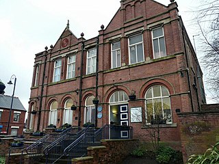
Audenshaw is a market town in Tameside, Greater Manchester, England, 4.9 miles (7.9 km) east of Manchester. Historically part of Lancashire, in 2011 it had a population of 11,419.

Mossley (/ˈmɒzli/) is a town and civil parish in Tameside, Greater Manchester, England. It is located in the upper Tame Valley and the foothills of the Pennines, 3 miles (4.8 km) south-east of Oldham and 8.9 miles (14.3 km) east of Manchester.

Droylsden is a town in Tameside, Greater Manchester, England, 4.1 miles (6.6 km) east of Manchester city centre and 2.2 miles (3.5 km) west of Ashton-under-Lyne, with a population at the 2011 Census of 22,689.

Denton and Reddish is a constituency represented in the House of Commons of the UK Parliament since 2005 by Andrew Gwynne of the Labour Party.

Audenshaw School is an all-boys secondary school in Audenshaw, Greater Manchester, England. Previously, the school was known as Audenshaw Grammar School. It opened to boys in 1932.
Tameside and Glossop Integrated Care NHS Foundation Trust is an integrated foundation Trust that operates from Tameside General Hospital situated in Ashton-under-Lyne. It serves the surrounding area of Tameside in Greater Manchester, and the town of Glossop and other smaller towns and villages in the north western part of the High Peak district of Derbyshire. Employing approximately 3,800 staff, the Trust provides a range of services both within the hospital and in the local community. This includes Accident and Emergency services, and full consultant-led obstetric and paediatric hospital services for women, children and babies.

The Longdendale Chain is a sequence of six reservoirs on the River Etherow in the Longdendale Valley, in northern Derbyshire. They were constructed between 1848 and 1884 to a design by John Frederick Bateman to supply the growing population of Manchester and Salford with fresh water.

Nico Ditch is a six-mile (9.7 km) long linear earthwork between Ashton-under-Lyne and Stretford in Greater Manchester, England. It was dug as a defensive fortification, or possibly a boundary marker, between the 5th and 11th century.

The Thirlmere Aqueduct is a 95.9-mile-long (154.3-kilometre-long) pioneering section of water supply system in England, built by the Manchester Corporation Water Works between 1890 and 1925. Often incorrectly thought of as one of the longest tunnels in the world, the aqueduct's tunnel section is not continuous.
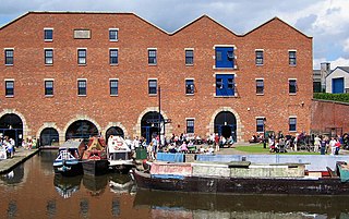
Dukinfield Junction is the name of the canal junction where the Peak Forest Canal, the Ashton Canal and the Huddersfield Narrow Canal meet near Ashton-under-Lyne, Greater Manchester, England. The area has been designated by Tameside Metropolitan Borough Council as a conservation area.
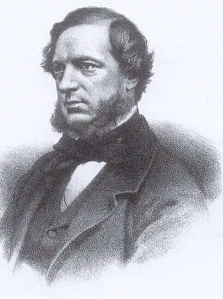
John Frederick La Trobe Bateman was an English civil engineer whose work formed the basis of the modern United Kingdom water supply industry. For more than 50 years from 1835 he designed and constructed reservoirs and waterworks. His largest project was the Longdendale Chain system that has supplied Manchester with much of its water since the 19th century. The construction of what was in its day the largest chain of reservoirs in the world began in 1848 and was completed in 1877. Bateman became "the greatest dam-builder of his generation".
The Mottram Tunnel is a tunnel carrying drinking water by gravity from Arnfield Reservoir, Tintwistle, Derbyshire, in the valley of the River Etherow, to Godley, Greater Manchester, in the valley of the River Tame. It was essential to the construction of the Longdendale Chain of reservoirs constructed by John Frederick Bateman. The tunnel was built between August 1848 and October 1850, and the Godley Reservoir was finished in 1851 to receive and filter the water.

Ashton-under-Lyne bus station is a bus station that is located in the town of Ashton-under-Lyne in Greater Manchester, run by Transport for Greater Manchester. The bus station is situated on Wellington Road and adjoins the Arcades Shopping Centre. The bus station was opened in 2020 and replaced the previous bus station that was built on the current site.
