Autonomous aircraft

Last updated

An autonomous aircraft is an aircraft which flies under the control of automatic systems and needs no intervention from a human pilot. Most autonomous aircraft are unmanned aerial vehicle or drones. However, autonomous control systems are reaching a point where several air taxis and associated regulatory regimes are being developed.

Contents

History

Unmanned aerial vehicles

Winston Churchill and others waiting to watch the launch of a de Havilland Queen Bee target drone, 6 June 1941 Winston Churchill and the Secretary of State for War waiting to see the launch of a de Havilland Queen Bee radio-controlled target drone, 6 June 1941. H10307.jpg
Winston Churchill and others waiting to watch the launch of a de Havilland Queen Bee target drone, 6 June 1941

The earliest recorded use of an unmanned aerial vehicle for warfighting occurred in July 1849, [1] serving as a balloon carrier (the precursor to the aircraft carrier) [2] Significant development of radio-controlled drones started in the early 1900s, and originally focused on providing practice targets for training military personnel. The earliest attempt at a powered UAV was A. M. Low's "Aerial Target" in 1916. [3]

Autonomous features such as the autopilot and automated navigation were developed progressively through the twentieth century, although techniques such as terrain contour matching (TERCOM) were applied mainly to cruise missiles.

Some modern drones have a high degree of autonomy, although they are not fully capable and the regulatory environment prohibits their widespread use in civil aviation. However some limited trials have been undertaken.

Passengers

As flight, navigation and communications systems have become more sophisticated, safely carrying passengers has emerged as a practical possibility. Autopilot systems are relieving the human pilot of progressively more duties, but the pilot currently remains necessary.

A number of air taxis are under development and larger autonomous transports are also being planned. The personal air vehicle is another class where from one to four passengers are not expected to be able to pilot the aircraft and autonomy is seen as necessary for widespread adoption.

Control system architecture

The computing capability of aircraft flight and navigation systems followed the advances of computing technology, beginning with analog controls and evolving into microcontrollers, then system-on-a-chip (SOC) and single-board computers (SBC).

Sensors

Position and movement sensors give information about the aircraft state. Exteroceptive sensors deal with external information like distance measurements, while exproprioceptive ones correlate internal and external states. [4]

Non-cooperative sensors are able to detect targets autonomously so they are used for separation assurance and collision avoidance. [5]

Degrees of freedom (DOF) refers to both the amount and quality of sensors on board: 6 DOF implies 3-axis gyroscopes and accelerometers (a typical inertial measurement unit   IMU), 9 DOF refers to an IMU plus a compass, 10 DOF adds a barometer and 11 DOF usually adds a GPS receiver. [6]

Actuators

UAV actuators include digital electronic speed controllers (which control the RPM of the motors) linked to motors/engines and propellers, servomotors (for planes and helicopters mostly), weapons, payload actuators, LEDs and speakers.

Software

UAV software called the flight stack or autopilot. The purpose of the flight stack is to obtain data from sensors, control motors to ensure UAV stability, and facilitate ground control and mission planning communication. [7]

UAVs are real-time systems that require rapid response to changing sensor data. As a result, UAVs rely on single-board computers for their computational needs. Examples of such single-board computers include Raspberry Pis, Beagleboards, etc. shielded with NavIO, PXFMini, etc. or designed from scratch such as NuttX, preemptive-RT Linux, Xenomai, Orocos-Robot Operating System or DDS-ROS 2.0.

Flight stack overview
LayerRequirementOperationsExample
FirmwareTime-criticalFrom machine code to processor execution, memory accessArduCopter-v1, PX4
MiddlewareTime-criticalFlight control, navigation, radio managementPX4, Cleanflight, ArduPilot
Operating systemComputer-intensiveOptical flow, obstacle avoidance, SLAM, decision-makingROS, Nuttx, Linux distributions, Microsoft IOT

Civil-use open-source stacks include:

Due to the open-source nature of UAV software, they can be customized to fit specific applications. For example, researchers from the Technical University of Košice have replaced the default control algorithm of the PX4 autopilot. [8] This flexibility and collaborative effort has led to a large number of different open-source stacks, some of which are forked from others, such as CleanFlight, which is forked from BaseFlight and from which three other stacks are forked from.

Loop principles

Typical flight-control loops for a multirotor UAV Flight control.jpg
Typical flight-control loops for a multirotor

UAVs employ open-loop, closed-loop or hybrid control architectures.

Communications

Most UAVs use a radio for remote control and exchange of video and other data. Early UAVs had only narrowband uplink. Downlinks came later. These bi-directional narrowband radio links carried command and control (C&C) and telemetry data about the status of aircraft systems to the remote operator. For very long range flights, military UAVs also use satellite receivers as part of satellite navigation systems. In cases when video transmission was required, the UAVs will implement a separate analog video radio link.

In most modern autonomous applications, video transmission is required. A broadband link is used to carry all types of data on a single radio link. These broadband links can leverage quality of service techniques to optimize the C&C traffic for low latency. Usually, these broadband links carry TCP/IP traffic that can be routed over the Internet.

Communications can be established with:

As mobile networks have increased in performance and reliability over the years, drones have begun to use mobile networks for communication. Mobile networks can be used for drone tracking, remote piloting, over the air updates, [14] and cloud computing. [15]

Modern networking standards have explicitly considered autonomous aircraft and therefore include optimizations. The 5G standard has mandated reduced user plane latency to 1ms while using ultra-reliable and low-latency communications. [16]

Autonomy

Autonomous control basics Autonomous control basics.jpg
Autonomous control basics

Basic autonomy comes from proprioceptive sensors. Advanced autonomy calls for situational awareness, knowledge about the environment surrounding the aircraft from exteroceptive sensors: sensor fusion integrates information from multiple sensors. [4]

Basic principles

One way to achieve autonomous control employs multiple control-loop layers, as in hierarchical control systems. As of 2016 the low-layer loops (i.e. for flight control) tick as fast as 32,000 times per second, while higher-level loops may cycle once per second. The principle is to decompose the aircraft's behavior into manageable "chunks", or states, with known transitions. Hierarchical control system types range from simple scripts to finite state machines, behavior trees and hierarchical task planners. The most common control mechanism used in these layers is the PID controller which can be used to achieve hover for a quadcopter by using data from the IMU to calculate precise inputs for the electronic speed controllers and motors.[ citation needed ]

Examples of mid-layer algorithms:

Evolved UAV hierarchical task planners use methods like state tree searches or genetic algorithms. [19]

Autonomy features

UAV's degrees of autonomy Degrees of autonomy.jpg
UAV's degrees of autonomy

UAV manufacturers often build in specific autonomous operations, such as:

Functions

Full autonomy is available for specific tasks, such as airborne refueling [20] or ground-based battery switching; but higher-level tasks call for greater computing, sensing and actuating capabilities. One approach to quantifying autonomous capabilities is based on OODA terminology, as suggested by a 2002 US Air Force Research Laboratory, and used in the table below: [21]

United States Autonomous control levels chart
LevelLevel descriptorObserveOrientDecideAct
Perception/Situational awarenessAnalysis/CoordinationDecision makingCapability
10Fully AutonomousCognizant of all within battlespaceCoordinates as necessaryCapable of total independenceRequires little guidance to do job
9Battlespace Swarm CognizanceBattlespace inference – Intent of self and others (allied and foes).

Complex/Intense environment – on-board tracking

Strategic group goals assigned

Enemy strategy inferred

Distributed tactical group planning

Individual determination of tactical goal

Individual task planning/execution

Choose tactical targets

Group accomplishment of strategic goal with no supervisory assistance
8Battlespace CognizanceProximity inference – Intent of self and others (allied and foes)

Reduces dependence upon off-board data

Strategic group goals assigned

Enemy tactics inferred

ATR

Coordinated tactical group planning

Individual task planning/execution

Choose target of opportunity

Group accomplishment of strategic goal with minimal supervisory assistance

(example: go SCUD hunting)

7Battlespace KnowledgeShort track awareness – History and predictive battlespace

Data in limited range, timeframe and numbers

Limited inference supplemented by off-board data

Tactical group goals assigned

Enemy trajectory estimated

Individual task planning/execution to meet goalsGroup accomplishment of tactical goals with minimal supervisory assistance
6Real Time

Multi-Vehicle Cooperation

Ranged awareness – on-board sensing for long range,

supplemented by off-board data

Tactical group goals assigned

Enemy trajectory sensed/estimated

Coordinated trajectory planning and execution to meet goals  group optimizationGroup accomplishment of tactical goals with minimal supervisory assistance

Possible: close air space separation (+/-100yds) for AAR, formation in non-threat conditions

5Real Time

Multi-Vehicle Coordination

Sensed awareness – Local sensors to detect others,

Fused with off-board data

Tactical group plan assigned

RT Health Diagnosis Ability to compensate for most failures and flight conditions;

Ability to predict onset of failures (e.g. Prognostic Health Mgmt)

Group diagnosis and resource management

On-board trajectory replanning – optimizes for current and predictive conditions

Collision avoidance

Self accomplishment of tactical plan as externally assigned

Medium vehicle airspace separation (hundreds of yds)

4Fault/Event Adaptative

Vehicle

Deliberate awareness – allies communicate dataTactical group plan assigned

Assigned Rules of Engagement

RT Health Diagnosis; Ability to compensate for most failures and flight conditions  inner loop changes reflected in outer loop performance

On-board trajectory replanning – event driven

Self resource management

Deconfliction

Self accomplishment of tactical plan as externally assigned

Medium vehicle airspace separation (hundreds of yds)

3Robust Response to Real Time Faults/EventsHealth/status history & modelsTactical group plan assigned

RT Health Diagnosis (What is the extent of the problems?)

Ability to compensate for most failures and flight conditions (i.e. adaptative inner loop control)

Evaluate status vs required mission capabilities

Abort/RTB is insufficient

Self accomplishment of tactical plan as externally assigned
2Changeable missionHealth/status sensorsRT Health diagnosis (Do I have problems?)

Off-board replan (as required)

Execute preprogrammed or uploaded plans

in response to mission and health conditions

Self accomplishment of tactical plan as externally assigned
1Execute Preplanned

Mission

Preloaded mission data

Flight Control and Navigation Sensing

Pre/Post flight BIT

Report status

Preprogrammed mission and abort plansWide airspace separation requirements (miles)
0Remotely

Piloted

Vehicle

Flight Control (attitude, rates) sensing

Nose camera

Telemetered data

Remote pilot commands

N/AControl by remote pilot

Medium levels of autonomy, such as reactive autonomy and high levels using cognitive autonomy, have already been achieved to some extent and are very active research fields.

Reactive autonomy

Reactive autonomy, such as collective flight, real-time collision avoidance, wall following and corridor centring, relies on telecommunication and situational awareness provided by range sensors: optic flow, [22] lidars (light radars), radars, sonars.

Most range sensors analyze electromagnetic radiation, reflected off the environment and coming to the sensor. The cameras (for visual flow) act as simple receivers. Lidars, radars and sonars (with sound mechanical waves) emit and receive waves, measuring the round-trip transit time. UAV cameras do not require emitting power, reducing total consumption.

Radars and sonars are mostly used for military applications.

Reactive autonomy has in some forms already reached consumer markets: it may be widely available in less than a decade. [4]

Cutting-edge (2013) autonomous levels for existing systems Autonomous-control-level-trend.png
Cutting-edge (2013) autonomous levels for existing systems

Simultaneous localization and mapping

SLAM combines odometry and external data to represent the world and the position of the UAV in it in three dimensions. High-altitude outdoor navigation does not require large vertical fields-of-view and can rely on GPS coordinates (which makes it simple mapping rather than SLAM). [23]

Two related research fields are photogrammetry and LIDAR, especially in low-altitude and indoor 3D environments.

Swarming

Robot swarming refers to networks of agents able to dynamically reconfigure as elements leave or enter the network. They provide greater flexibility than multi-agent cooperation. Swarming may open the path to data fusion. Some bio-inspired flight swarms use steering behaviors and flocking.[ clarification needed ]

Future military potential

In the military sector, American Predators and Reapers are made for counterterrorism operations and in war zones in which the enemy lacks sufficient firepower to shoot them down. They are not designed to withstand antiaircraft defenses or air-to-air combat. In September 2013, the chief of the US Air Combat Command stated that current UAVs were "useless in a contested environment" unless crewed aircraft were there to protect them. A 2012 Congressional Research Service (CRS) report speculated that in the future, UAVs may be able to perform tasks beyond intelligence, surveillance, reconnaissance and strikes; the CRS report listed air-to-air combat ("a more difficult future task") as possible future undertakings. The Department of Defense's Unmanned Systems Integrated Roadmap FY2013-2038 foresees a more important place for UAVs in combat. Issues include extended capabilities, human-UAV interaction, managing increased information flux, increased autonomy and developing UAV-specific munitions. DARPA's project of systems of systems, [30] or General Atomics work may augur future warfare scenarios, the latter disclosing Avenger swarms equipped with High Energy Liquid Laser Area Defense System (HELLADS). [31]

Cognitive radio

Cognitive radio [ clarification needed ] technology may have UAV applications. [32]

Learning capabilities

UAVs may exploit distributed neural networks. [4]

See also

Related Research Articles

An autonomous robot is a robot that acts without recourse to human control. Historic examples include space probes. Modern examples include self-driving vacuums and cars.

<span class="mw-page-title-main">Unmanned aerial vehicle</span> Aircraft without any human pilot on board

An unmanned aerial vehicle (UAV), commonly known as a drone, is an aircraft without any human pilot, crew, or passengers on board. UAVs were originally developed through the twentieth century for military missions too "dull, dirty or dangerous" for humans, and by the twenty-first, they had become essential assets to most militaries. As control technologies improved and costs fell, their use expanded to many non-military applications. These include aerial photography, area coverage, precision agriculture, forest fire monitoring, river monitoring, environmental monitoring, policing and surveillance, infrastructure inspections, smuggling, product deliveries, entertainment, and drone racing.

<span class="mw-page-title-main">Micro air vehicle</span> Class of very small unmanned aerial vehicle

A micro air vehicle (MAV), or micro aerial vehicle, is a class of man-portable miniature UAVs whose size enables them to be used in low-altitude, close-in support operations. Modern MAVs can be as small as 5 centimeters - compare Nano Air Vehicle. Development is driven by commercial, research, government, and military organizations; with insect-sized aircraft reportedly expected in the future. The small craft allow remote observation of hazardous environments or of areas inaccessible to ground vehicles. Hobbyists have designed MAVs for applications such as aerial robotics contests and aerial photography. MAVs can offer autonomous modes of flight.

<span class="mw-page-title-main">Swarm robotics</span> Coordination of multiple robots as a system

Swarm robotics is an approach to the coordination of multiple robots as a system which consist of large numbers of mostly simple physical robots. ″In a robot swarm, the collective behavior of the robots results from local interactions between the robots and between the robots and the environment in which they act.″ It is supposed that a desired collective behavior emerges from the interactions between the robots and interactions of robots with the environment. This approach emerged on the field of artificial swarm intelligence, as well as the biological studies of insects, ants and other fields in nature, where swarm behaviour occurs.

<span class="mw-page-title-main">Aerial survey</span> Method of collecting geophysical data from high altitude aircraft

Aerial survey is a method of collecting geomatics or other imagery by using airplanes, helicopters, UAVs, balloons or other aerial methods. Typical types of data collected include aerial photography, Lidar, remote sensing and also geophysical data (such as aeromagnetic surveys and gravity. It can also refer to the chart or map made by analysing a region from the air. Aerial survey should be distinguished from satellite imagery technologies because of its better resolution, quality and atmospheric conditions. Today, aerial survey is sometimes recognized as a synonym for aerophotogrammetry, part of photogrammetry where the camera is placed in the air. Measurements on aerial images are provided by photogrammetric technologies and methods.

<span class="mw-page-title-main">AeroVironment</span> American unmanned aerial vehicle manufacturer

AeroVironment, Inc. is an American defense contractor headquartered in Arlington, Virginia, that designs and manufactures unmanned aerial vehicles (UAVs). Paul B. MacCready Jr., a designer of human-powered aircraft, founded the company in 1971. The company is best known for its lightweight human-powered and solar-powered vehicles. The company is the US military's top supplier of small drones —notably the Raven, Switchblade, Wasp and Puma models.

<span class="mw-page-title-main">Lockheed DC-130</span> American military UAV carrier

The Lockheed DC-130 is a variant of the C-130 Hercules modified for drone control. It can carry four Ryan Firebee drones underneath its wings.

The usefulness of UAVs for aerial reconnaissance was demonstrated to the United States in the Vietnam War. At the same time, early steps were being taken to use them in active combat at sea and on land, but unmanned combat aerial vehicles would not come into their own until the 1980s.

<span class="mw-page-title-main">Boeing A160 Hummingbird</span> Unmanned aerial vehicle by Boeing

The Boeing A160 Hummingbird is an unmanned aerial vehicle (UAV) helicopter. Its design incorporates many new technologies never before used in helicopters, allowing for greater endurance and altitude than any helicopter currently in operation.

<span class="mw-page-title-main">First-person view (radio control)</span> Controlling a radio-controlled vehicle from the driver or pilots view point

First-person view (FPV), also known as remote-person view (RPV), or video piloting, is a method used to control a radio-controlled vehicle from the driver or pilot's viewpoint. Most commonly it is used to pilot a radio-controlled aircraft or other type of unmanned aerial vehicle (UAV) such as a military drone. The operator gets a first-person perspective from an onboard camera that feeds video to FPV goggles or a monitor. More sophisticated setups include a pan-and-tilt gimbaled camera controlled by a gyroscope sensor in the pilot's goggles and with dual onboard cameras, enabling a true stereoscopic view.

The Australian Research Centre for Aerospace Automation (ARCAA) was a research centre of the Queensland University of Technology. ARCAA conducted research into all aspects of aviation automation, with a particular research focus on autonomous technologies which support the more efficient and safer utilisation of airspace, and the development of autonomous aircraft and on-board sensor systems for a wide range of commercial applications.

<span class="mw-page-title-main">Uncrewed vehicle</span> Type of vehicle

An uncrewed vehicle or unmanned vehicle is a vehicle without a person on board. Uncrewed vehicles can either be under telerobotic control—remote controlled or remote guided vehicles—or they can be autonomously controlled—autonomous vehicles—which are capable of sensing their environment and navigating on their own.

<span class="mw-page-title-main">DRDO Ghatak</span> Type of aircraft

Ghatak is an autonomous jet powered stealthy unmanned combat air vehicle (UCAV), being developed by Aeronautical Development Establishment (ADE) of the Defence Research and Development Organisation (DRDO) for the Indian Air Force. The design work on the UCAV is to be carried out by Aeronautical Development Agency (ADA). Autonomous Unmanned Research Aircraft (AURA) was a tentative name for the UCAV. Details of the project are classified.

Paparazzi is an open-source autopilot system oriented toward inexpensive autonomous aircraft. Low cost and availability enable hobbyist use in small remotely piloted aircraft. The project began in 2003, and is being further developed and used at École nationale de l'aviation civile (ENAC), a French civil aeronautics academy. Several vendors are currently producing Paparazzi autopilots and accessories.

ArduPilot is an open source, uncrewed vehicle Autopilot Software Suite, capable of controlling:

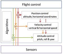
Unmanned aircraft system simulation focuses on training pilots to control an unmanned aircraft or its payload from a control station. Flight simulation involves a device that artificially re-creates aircraft flight and the environment in which it flies for pilot training, design, or other purposes. It includes replicating the equations that govern how aircraft fly, how they react to applications of flight controls, the effects of other aircraft systems, and how the aircraft reacts to external factors such as air density, turbulence, wind shear, cloud, precipitation, etc.

<span class="mw-page-title-main">INDELA-I.N.SKY</span> Type of aircraft

INDELA-I.N.SKY is a Belarusian rotary wing unmanned aerial vehicle, medium-range with the weight up to 140 kg. It is developed and produced by KB INDELA Ltd. Serial production has been set up since 2014.

Primoco UAV is a Czech company that creates unmanned aerial vehicles designed for both civilian and military applications. Its first model took flight in July 2015 and the UAV Model One 100 started full production in January 2016.

<span class="mw-page-title-main">Raytheon Coyote</span> Type of aircraft

The Raytheon Coyote is a small, expendable, unmanned aircraft system built by the Raytheon Company, with the capability of operating in autonomous swarms. It is launched from a sonobuoy canister with the wings deploying in early flight phase.

<span class="mw-page-title-main">HAL Combat Air Teaming System</span> Indian air teaming system

The HAL Combat Air Teaming System (CATS) is an Indian unmanned and manned combat aircraft air teaming system being developed by Hindustan Aeronautics Limited (HAL). The system will consist of a manned fighter aircraft acting as "mothership" of the system and a set of swarming UAVs and UCAVs governed by the mothership aircraft. A twin-seated HAL Tejas is likely to be the mothership aircraft. Various other sub components of the system are currently under development and will be jointly produced by HAL, National Aerospace Laboratories (NAL), Defence Research and Development Organisation (DRDO) and Newspace Research & Technologies.

References

  1. The Future of Drone Use: Opportunities and Threats from Ethical and Legal Perspectives, Asser Press  Springer, chapter by Alan McKenna, page 355
  2. Kaplan, Philip (2013). Naval Aviation in the Second World War. Pen and Sword. p. 19. ISBN   978-1-4738-2997-8.
  3. Taylor, John W. R.. Jane's Pocket Book of Remotely Piloted Vehicles.
  4. 1 2 3 4 Floreano, Dario; Wood, Robert J. (27 May 2015). "Science, technology and the future of small autonomous drones". Nature. 521 (7553): 460–466. Bibcode:2015Natur.521..460F. doi:10.1038/nature14542. PMID   26017445. S2CID   4463263.
  5. Fasano, Giancarmine; Accardo, Domenico; Tirri, Anna Elena; Moccia, Antonio; De Lellis, Ettore (1 October 2015). "Radar/electro-optical data fusion for non-cooperative UAS sense and avoid". Aerospace Science and Technology. 46: 436–450. Bibcode:2015AeST...46..436F. doi: 10.1016/j.ast.2015.08.010 .
  6. "Arduino Playground – WhatIsDegreesOfFreedom6DOF9DOF10DOF11DOF". playground.arduino.cc. Retrieved 4 February 2016.
  7. Carlson, Daniel F.; Rysgaard, Søren (1 January 2018). "Adapting open-source drone autopilots for real-time iceberg observations". MethodsX. 5: 1059–1072. doi:10.1016/j.mex.2018.09.003. ISSN   2215-0161. PMC   6139390 . PMID   30225206.
  8. Lesko, J.; Schreiner, M.; Megyesi, D.; Kovacs, Levente (November 2019). "Pixhawk PX-4 Autopilot in Control of a Small Unmanned Airplane". 2019 Modern Safety Technologies in Transportation (MOSATT). Kosice, Slovakia: IEEE. pp. 90–93. doi:10.1109/MOSATT48908.2019.8944101. ISBN   978-1-7281-5083-3. S2CID   209695691.
  9. Bristeau, Callou, Vissière, Petit (2011). "The Navigation and Control technology inside the AR.Drone micro UAV" (PDF). IFAC World Congress.{{cite web}}: CS1 maint: multiple names: authors list (link)
  10. Barnard, Joseph (2007). "Small UAV Command, Control and Communication Issues" (PDF). Barnard Microsystems.
  11. "The Cheap Drone Camera That Transmits to Your Phone". Bloomberg.com. Retrieved 3 February 2016.
  12. "Cellular enables safer drone deployments". Qualcomm. Retrieved 9 May 2018.
  13. "Identifying Critical Manned-Unmanned Teaming Skills for Unmanned Aircraft System Operators" (PDF). U.S. Army Research Institute for the Behavioral and Social Sciences. September 2012. Archived (PDF) from the original on 6 February 2016.
  14. USapplication 20170127245,Adkins, Timothy M.,"4G drone link",published 2017-05-04, now abandoned.
  15. Sharma, Navuday; Magarini, Maurizio; Jayakody, Dushantha Nalin K.; Sharma, Vishal; Li, Jun (August 2018). "On-Demand Ultra-Dense Cloud Drone Networks: Opportunities, Challenges and Benefits". IEEE Communications Magazine. 56 (8): 85–91. doi:10.1109/MCOM.2018.1701001. hdl: 11311/1063273 . ISSN   1558-1896. S2CID   52019723.
  16. "Minimum requirements related to technical performance for IMT-2020 radio interface(s)". www.itu.int. Retrieved 8 October 2020.
  17. Roberge, V.; Tarbouchi, M.; Labonte, G. (1 February 2013). "Comparison of Parallel Genetic Algorithm and Particle Swarm Optimization for Real-Time UAV Path Planning". IEEE Transactions on Industrial Informatics. 9 (1): 132–141. doi:10.1109/TII.2012.2198665. ISSN   1551-3203. S2CID   8418538.
  18. Tisdale, J.; Kim, ZuWhan; Hedrick, J.K. (1 June 2009). "Autonomous UAV path planning and estimation". IEEE Robotics Automation Magazine. 16 (2): 35–42. doi:10.1109/MRA.2009.932529. ISSN   1070-9932. S2CID   9696725.
  19. Cekmez, Ozsiginan, Aydin And Sahingoz (2014). "UAV Path Planning with Parallel Genetic Algorithms on CUDA Architecture" (PDF). World congress on engineering.{{cite web}}: CS1 maint: multiple names: authors list (link)
  20. Davenport, Christian (23 April 2015). "Watch a step in Navy history: an autonomous drone gets refueled mid-air". The Washington Post. ISSN   0190-8286 . Retrieved 3 February 2016.
  21. Clough, Bruce (August 2002). "Metrics, Schmetrics! How The Heck Do You Determine A UAV's Autonomy Anyway?" (PDF). US Air Force Research Laboratory. Archived (PDF) from the original on 6 February 2016.
  22. Serres, Julien R.; Masson, Guillaume P.; Ruffier, Franck; Franceschini, Nicolas (2008). "A bee in the corridor: centering and wall-following" (PDF). Naturwissenschaften. 95 (12): 1181–1187. Bibcode:2008NW.....95.1181S. doi:10.1007/s00114-008-0440-6. PMID   18813898. S2CID   226081.
  23. Roca, Martínez-Sánchez, Lagüela, and Arias (2016). "Novel Aerial 3D Mapping System Based on UAV Platforms and 2D Laser Scanners". Journal of Sensors. 2016: 1–8. doi: 10.1155/2016/4158370 .{{cite journal}}: CS1 maint: multiple names: authors list (link)
  24. "ETH Zurich: Drones with a Sense of Direction". Ascending Technologies GmbH. 10 November 2015. Retrieved 3 February 2016.
  25. Timothy B. Lee (1 January 2018). "Why experts believe cheaper, better lidar is right around the corner" via Ars Technica.
  26. Shaojie Shen (16 November 2010), Autonomous Aerial Navigation in Confined Indoor Environments , retrieved 3 February 2016
  27. "SWEEPER Demonstrates Wide-Angle Optical Phased Array Technology". www.darpa.mil. Retrieved 3 February 2016.
  28. "LIDAR: LIDAR nears ubiquity as miniature systems proliferate". www.laserfocusworld.com. 13 October 2015. Retrieved 3 February 2016.
  29. Quack, Ferrara, Gambini, Han, Keraly, Qiao, Rao, Sandborn, Zhu, Chuang, Yablonovitch, Boser, Chang-Hasnain, C. Wu (2015). "Development of an FMCW LADAR Source Chip using MEMS-Electronic-Photonic Heterogeneous Integration". University of California, Berkeley.{{cite web}}: CS1 maint: multiple names: authors list (link)
  30. "DARPA's Plan to Overwhelm Enemies With Swarming Drones – Drone 360". Drone 360. 6 April 2015. Retrieved 3 February 2016.
  31. NewWorldofWeapons (17 January 2014), US Air force STEALTH UAV armed with LASER GUN named General Atomics Avenger , retrieved 3 February 2016
  32. Young (December 2012). "Unified Multi-domain Decision Making: Cognitive Radio and Autonomous Vehicle Convergence". Faculty of the Virginia Polytechnic Institute and State University. hdl:10919/19295 . Retrieved 18 September 2020.