Avenida Rio Branco

Last updated
Rio Branco Avenue
Avenida Rio Branco, Rio de Janeiro.jpg
Native nameAvenida Rio Branco (Portuguese)
Former name(s)Avenida Central
Length1,800 m (5,900 ft)
Width33 metres (108 ft)
Location Rio de Janeiro, Brazil
Coordinates 22°54′17″S43°10′39″W / 22.90472°S 43.17750°W / -22.90472; -43.17750
NorthPraça Mauá
EastPres. Antonio Carlos Avenue
SouthBeira-Mar Avenue
WestRepublic of Paraguay Avenue
Construction
InaugurationSeptember 7, 1904

Rio Branco Avenue (Portuguese : Avenida Rio Branco), formerly Avenida Central, is a major road in downtown Rio de Janeiro. It was built as the leading brand of the urban reform carried out by the mayor Pereira Passos in early 20th century. [1]

Contents

It is one of the main thoroughfares of the city, being the scene of many important events.

History

Rio Branco Avenue in the 1930s AvenidaRioBranco1930.jpg
Rio Branco Avenue in the 1930s

The Rio de Janeiro of the early years of Republic still retained much of its colonial urban grid, which by now seemed outdated and anachronistic. Moreover, the old colonial center of town was overcrowded and prone to diseases such as yellow fever and smallpox. Out of this context came the opening of Central Avenue, part of a major modernization program in Rio de Janeiro following European urban planning and health policies.

The engineer Francisco Pereira Passos was responsible for the reforms, appointed mayor of Rio de Janeiro (Distrito Federal) by President Rodrigues Alves in 1902. The works commenced in March 1904 with the demolition of 641 homes, displacing nearly 3,900 people. The avenue was open after six months of work.

At the same time, Mangue Avenue was opened, Morro do Senado was torn down, the downtown's street were widened, parts of the Guanabara Bay's shore were developed and began the urbanization of Copacabana among other reforms. At the end of the government of Pereira Passos, in 1906, the city had a new look.

Architecture and urban planning

The Central Avenue linking the new port city (where the current Praca Maua) to the region glory, which at that time was expanding urbanism. The engineer Paulo de Frontin, head of the Construction Committee of Central Avenue, was responsible for the project. The new avenue was 1800 meters long and 33 meters wide and three hundred colonial houses were razed in the process to raise modern buildings. The facades of buildings for the Central Avenue were chosen in a contest, in which jurors were, among others, Mayor Pereira Passos, Paulo de Front in the Minister of Transportation and Public Works, Lauro Müller and the Director General of Public Health Oswaldo Cruz.

Rio Branco Avenue Avenida Rio Branco, Rio de Janeiro (RJ).jpg
Rio Branco Avenue

The buildings are finally constructed work of various architects, usually of European origin, with some Brazilians as Heitor de Melo, Gabriel Junqueira, Francisco Monteiro de Azevedo Caminhoá and Ramos de Azevedo. The first to be erected, now demolished, was the Tobacconist London. In stylistic terms, the construction of Central Avenue is the pinnacle of eclectic style monumental in Rio besides government buildings, rose several hotels, corporate offices, newspapers, clubs, etc.. The predominant style was eclectic Frenchified, but several other models were followed, as the eclectic Italianate, neo-Gothic, neo-classical, among others. The avenue had a central garden plot and electric lighting. The sidewalks in Portuguese mosaic were made by craftsmen from Portugal.

The avenue ended at Central Praça Floriano Peixoto (Now known as Cinelândia), around which were erected several public buildings of great architectural value that still exist: the Theatre, the National School of Fine Arts (Now National Museum of Fine Arts) And the National Library. At the end of the avenue was constructed Monroe Palace, Senate seat, unfortunately destroyed in 1976.

The avenue was opened on September 7 of 1904 President of the Republic, Rodrigues Alves and delivered to traffic on November 15 of 1905. Received beautiful trees, which started on October 22, 1905, by planting the first tree pau-Brazil. When increased, but the trees were removed and the sidewalk that divided in half.

Changes and distortion

Tram passes along Rio Branco Avenue. Viagem inaugural do VLT carioca 01.jpg
Tram passes along Rio Branco Avenue.

On February 21 of 1912, the name was changed to Avenue (Avenida) Rio Branco in honor of Rio Branco, Brazilian diplomat responsible for treaties which guaranteed the borders of Brazil who had died on February 10. [2]

From the 1940s, with the advancement of architectural concrete, The avenue began to appear architecturally disfigured, to the point where, today, only a handful of original buildings are preserved. The much greater height of these newer buildings leaves little of the original scale remaining, and much of the street is constantly cast into shadow.

The Avenida Rio Branco is still one of the most important arteries of the city, in which are some of the major banks and offices in Rio de Janeiro.

Related Research Articles

<span class="mw-page-title-main">Paulista Avenue</span> Avenue in São Paulo

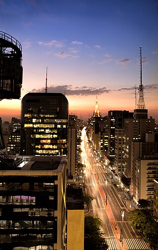
Paulista Avenue is one of the most important avenues in São Paulo, Brazil. It stretches 2.8 kilometres (1.7 mi) and runs northwest to southeast. Its northwest point is Praça Marechal Cordeiro de Farias at its intersection with Rua da Consolação and its southeast point is Praça Oswaldo Cruz at its intersection with Treze de Maio, Bernardino de Campos, Desembargador Eliseu Guilherme, and Dr. Rafael de Barros avenues. Major crossroads on the street are Rua Augusta, Rua Haddock Lobo and Avenida Brigadeiro Luis Antonio. Parallel to it are Cincinato Braga, Joaquim Eugenio de Lima on the Bela Vista/Paraíso side and Alameda Santos and Coronel Oscar Freire on the Jardins side. Paulista Avenue crosses sections of the neighborhoods of Paraíso, Bela Vista, Jardim Paulista, Cerqueira César and Jardim América, ending in Higienópolis.

<span class="mw-page-title-main">Viçosa, Minas Gerais</span> Municipality in Southeast, Brazil

Viçosa is a Brazilian municipality in the state of Minas Gerais. Its population as of 2021 was estimated at 79,910 inhabitants.

<span class="mw-page-title-main">Caetité</span> Municipality in Bahia, Brazil

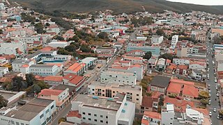
Caetité is a Brazilian municipality in the state of Bahia. It is located in the semi-arid sertão region in the interior of the state. It had an estimated 51,081 inhabitants as of 2020. It covers 2,651.5 square kilometres (1,023.7 sq mi) and is 757 kilometres (470 mi) from the state capital, Salvador. Caetité borders on ten other municipalities, all within Bahia: Igaporã, Guanambi, Pindaí, Licínio de Almeida, Caculé, Ibiassucê, Lagoa Real, Livramento do Brumado, Paramirim, and Tanque Novo.

<span class="mw-page-title-main">Vaccine Revolt</span> 1904 week of civil disorder in Rio de Janeiro, Brazil

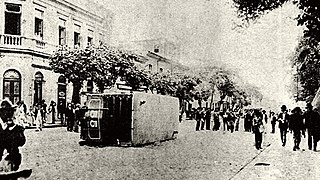
The Vaccine Revolt was a popular riot that took place between 10 and 16 November 1904 in the city of Rio de Janeiro, then the capital of Brazil. Its immediate pretext was a law that made vaccination against smallpox compulsory, but it is also associated with deeper causes, such as the urban reforms being carried out by mayor Pereira Passos and the sanitation campaigns led by physician Oswaldo Cruz.

<span class="mw-page-title-main">Theatro Municipal (Rio de Janeiro)</span> Opera house in Centro, Rio de Janeiro

<span class="mw-page-title-main">Lauro Müller</span>

Lauro Severiano Müller was a Brazilian politician, diplomat, and military engineer. Responsible for the transition of Santa Catarina from a province to a state, he is also recognised as one of those who helped achieve the Brazilian diplomatic victory over Bolivia through the Treaty of Petrópolis, which allowed for the purchase of Acre and its incorporation into Brazil.

<span class="mw-page-title-main">Cinelândia</span> Public square in central Rio de Janeiro, Brazil

<span class="mw-page-title-main">Santo Antônio do Rio Abaixo</span> Human settlement in Brazil

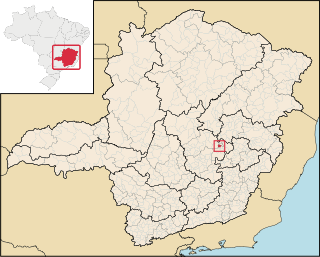
Santo Antônio do Rio Abaixo is a Brazilian municipality located in the state of Minas Gerais. The city belongs to the mesoregion of Belo Horizonte and to the microregion of Conceição do Mato Dentro. The estimated population in 2020 was 1,760 inhabitants.

<span class="mw-page-title-main">Brazilian National Archives</span>

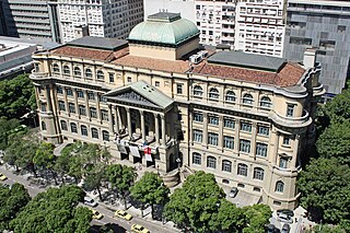
The National Archives of Brazil were created in 1838 as the Imperial Public Archives. The Archives were renamed in 1911, and are located in Rio de Janeiro. The National Archives of Brazil is the Brazilian institution responsible for the management, preservation and dissemination of federal government documents. Since 2011, it is subordinated to the Ministry of Justice and Public Security.

<span class="mw-page-title-main">Jacobina</span> Municipality in Bahia, Brazil

Jacobina is a city in the Centro Norte Baiano mesoregion of Bahia. It was founded July 28, 1722 and the population is 80,635. The town is surrounded by mountains, hills, lakes, rivers, springs, and waterfalls. Located in the northwest region of Bahia, in the extreme north of the Chapada Diamantina, Jacobina is 330 kilometers from Salvador and is also known as 'City of Gold', a legacy of the gold mines which attracted the pioneers from São Paulo in the early seventeenth century.

<span class="mw-page-title-main">Castelo, Rio de Janeiro</span> Area of the Centro neighborhood in Rio de Janeiro, Brazil

Castelo is a region in Rio de Janeiro, Brazil, but not officially recognized as a neighborhood, and officially forms part of the Centro neighborhood. It is generally considered to be located in the region between Avenida Rio Branco, the Santos Dumont Airport and Praça Quinze de Novembro. The area derives its name from the former Morro do Castelo in that location, which was demolished by water jets in the 1920s. As most of the buildings in the area were designed and built in the first half of the twentieth century, after the demolition of Morro do Castelo in 1921, the region became home to a large collection of Art Deco buildings. Art Deco was the prevalent architectural style in Rio de Janeiro at that time.

<span class="mw-page-title-main">Joseph Gire Building</span> Office building in Rio de Janeiro, Brazil

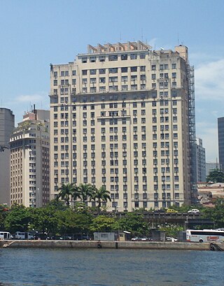
The Joseph Gire Building, better known as the A Noite Building or Edificio o Jornal A Noite, is an office building located in Rio de Janeiro, Brazil that served as the headquarters of the Rio-based newspaper A Noite. At a height of 102 meters, it was the tallest building in Brazil for two years between 1927 and 1929 before it was surpassed by the Martinelli Building in São Paulo.

<span class="mw-page-title-main">BR-040 (Brazil highway)</span>

BR-040 is a federal highway of Brazil. The 1,139.3 kilometres (707.9 mi) road connects Brasilia to Rio de Janeiro.

<span class="mw-page-title-main">Francisco Prestes Maia</span>

Francisco Prestes Maia (1896–1965) was a Brazilian architect, civil engineer, urban planner, and professor, who served three terms as mayor of the city of São Paulo.

<span class="mw-page-title-main">Ramos de Azevedo</span>

Francisco de Paula Ramos de Azevedo was a Brazilian architect, known for designing various buildings and landmarks in São Paulo, such as the Teatro Municipal, the Mercado Municipal and the Pinacoteca. He was one of the founders and director of the University of São Paulo's Polytechnical School.

<span class="mw-page-title-main">Books in Brazil</span>

The history of the book in Brazil focuses on the development of the access to publishing resources and acquisition of the book in the country, covering a period extending from the beginning of the editorial activity during colonization to today's publishing market, including the history of publishing and bookstores that allowed the modern accessibility to the book.

<span class="mw-page-title-main">Pereira Passos</span>

Francisco Pereira Passos was a Brazilian engineer and politician. He was mayor of the Federal District of Brazil from 1902 to 1906, nominated by President Rodrigues Alves. During his tenure, Pereira Passos promoted a large-scale urban renewal plan for Rio, inspired by Georges-Eugène Haussmann's renewal of Paris.

<span class="mw-page-title-main">Outline of Rio de Janeiro</span> Overview of and topical guide to Rio de Janeiro

The following outline is provided as an overview of and topical guide to Rio de Janeiro:

<span class="mw-page-title-main">Vale do Anhangabaú</span>

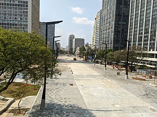
Vale do Anhangabaú is a region in the city center of São Paulo, located between the viaducts do Chá and Santa Ifigênia. It is a public space commonly characterized as park, where events have traditionally been organized, such as public demonstrations, political rallies, presentations and popular shows. It is considered the point that separates the Old City Center from the New City Center.

References

  1. Carranza, Luis E.; Lara, Fernando Luiz (2015-01-05). Modern Architecture in Latin America: Art, Technology, and Utopia. University of Texas Press. ISBN   9780292762978.
  2. February 10, 1912 - Death of Date José Paranhos, Baron of Rio Branco