Avenue Louise

Last updated

Avenue Louise (1).JPG
The Avenue Louise/Louizalaan in winter
Map Bruxelles-Capitale.jpg
Reddot.svg
Location within Brussels
Belgium location map.svg
Red pog.svg
Avenue Louise (Belgium)
Location City of Brussels, Brussels-Capital Region, Belgium
Coordinates 50°49′37″N04°21′52″E / 50.82694°N 4.36444°E / 50.82694; 4.36444
Construction
Commissioned1847

The Avenue Louise (French: [av.nylwiz] ) or Louizalaan (Dutch) is a major thoroughfare in Brussels, Belgium. It is located in the southern part of the City of Brussels, on the border with the municipality of Ixelles, where it runs south–east from the Place Louise/Louizaplein  [ nl ] to the Bois de la Cambre/Ter Kamerenbos, covering a distance of 2.7 km (1.7 mi). It is named in honour of King Leopold II's eldest daughter, Princess Louise (1858–1924).

Contents

The Avenue Louise is one of the most prestigious and expensive avenues in Brussels, lined with high-end fashion stores and boutiques. It also houses many embassies and offices. The avenue is served by the metro station Louise/Louiza at one end (on lines 2 and 6), as well as the tram lines 8 and 93, which run its entire length. [1] [2]

History

Construction

The construction of the Avenue Louise was commissioned in 1847 as a monumental avenue bordered by chestnut trees that would allow easy access from Brussels' city centre to the popular recreational area of the Bois de la Cambre/Ter Kamerenbos. It was also to be the first Haussmann-esque artery of the city. Its name was chosen in honour of King Leopold II's eldest daughter, Princess Louise, as is the Place Louise/Louizaplein, a major square located in its upper part. The Place Stéphanie/Stefanieplein, another square on the avenue, is named in honour of her younger sister, Princess Stéphanie.

The Avenue Louise from the Place Stephanie
/Stefanieplein
, c. 1920 Louisalaan Brussel met oude trams.jpg
The Avenue Louise from the Place Stéphanie/Stefanieplein, c.1920

Originally, fierce resistance to the project was put up by the town of Ixelles—then, as now, a separate municipality (local authority) from the City of Brussels—through whose territory the avenue was to run. After years of fruitless negotiations, Brussels finally annexed the narrow band of land needed for the avenue, in addition to the Bois de la Cambre itself, in 1864. That decision accounts for the unusual shape of today's City of Brussels and for the separation of Ixelles into two separate areas.

World War II

Bust of Jean de Selys Longchamps in front of the Gestapo's former headquarters, at number 453 Jean de SELYS-LONGCHAMP-av Louise.jpg
Bust of Jean de Sélys Longchamps in front of the Gestapo's former headquarters, at number 453

During World War II, following the German invasion of Belgium, Brussels was occupied by the German military. The Nazi security organisation, the Sicherheitspolizei-Sicherheitsdienst (Sipo-SD), of which the Gestapo was a part, set up their Brussels headquarters on the Avenue Louise. [3] They occupied numbers 347, 418, 453 and 510; [3] initially their headquarters were at number 453, in the Résidence Belvédère. [4]

On 20 January 1943, Baron Jean de Sélys Longchamps, a Brussels-born fighter pilot in the Royal Air Force, mounted a solo attack on the headquarters at number 453. [5] Benefiting from the wide avenues, and the large height of the apartment block relative to the neighbouring buildings, he flew his Hawker Typhoon at a low altitude straight towards the building, firing the plane's 20 mm cannons, before returning to England. [5] Following this attack, the SD moved their headquarters to number 347. [3] The cellars at this address were used to detain and interrogate captured members of the Belgian resistance. [6] The torture that took place there brought the Avenue Louise's name considerable infamy at the time. [7] A monument to Baron de Selys Longchamps now stands in front of number 453. [8]

Contemporary

The avenue was redeveloped after 1950 in preparation for the 1958 Brussels World's Fair (Expo 58), tunnelling the main intersections and offering direct access to the Small Ring (Brussels' inner ring road). The northern part is sunken and has three level crossings. The three tunnels are, from north to south: the Stéphanie Tunnel, the Bailli Tunnel and the short Vleurgat Tunnel.

Much of the post-war configuration still exists today. It implies that no metro line runs through the avenue, despite its high built density and its multiple functions of shops/offices/housing, the latter being in a way replaced by these tunnels. However, tram lines 8 and 93 operate on their own site from the Place Stéphanie to the Woluwe depot.

Although regarded as a prestigious street, at night it has a reputation for unauthorised prostitution. [9] [10] [11]

Landmarks

The Avenue Louise is home to many upmarket shops, restaurants and offices. From north to south, notable landmarks include:

The "Louise bottleneck"

The "Louise bottleneck" Brusel, Louise III.jpg
The "Louise bottleneck"

The 250-metre-long (820 ft) part of the Avenue Louise between the Place Louise/Louizaplein and the Place Stéphanie/Stefanieplein is called le goulet Louise in French ("the Louise bottleneck"). With two tramway lines and thousands of cars sharing this narrow segment of the avenue, large traffic jams occur during rush hours. The problem was already obvious in the early 1980s, so a tram tunnel under the bottleneck was built along with the metro station on the Place Louise. However, construction was abandoned toward its end due to protests of local businesses fearing losses if patrons were to be diverted through a tunnel. [12]

The nearly-completed, vast tramway tunnel under the Louise bottleneck remains unused as of 2009. Various solutions to the traffic problem have been considered. One proposes pedestrianising the whole segment, with trams running on the surface and only delivery vehicles authorised at certain hours. Another, much more costly idea, involves finishing the tunnel and diverting all trams underground.

Tramway lines 8 and 93 run the entire length of the avenue, all on segregated track except in the short "goulet Louise" section.

Embassies

The Avenue Louise houses many embassies, including those of:

Representative Offices

See also

Related Research Articles

<span class="mw-page-title-main">Brussels Metro</span> Public rapid-transit system serving the Brussels-Capital Region, Belgium

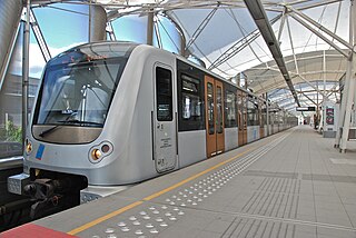
The Brussels Metro is a rapid transit system serving a large part of the Brussels-Capital Region of Belgium. It consists of four conventional metro lines and three premetro lines. The metro-grade lines are M1, M2, M5, and M6 with some shared sections, covering a total of 39.9 kilometres (24.8 mi), with 59 metro-only stations. The premetro network consists of three tram lines that partly travel over underground sections that were intended to be eventually converted into metro lines. Underground stations in the premetro network use the same design as metro stations. A few short underground tramway sections exist, so there is a total of 52.0 kilometres (32.3 mi) of underground metro and tram network. There are a total of 69 metro and premetro stations as of 2011.

<span class="mw-page-title-main">City of Brussels</span> Municipality of the Brussels-Capital Region and capital of Belgium

The City of Brussels is the largest municipality and historical centre of the Brussels-Capital Region, as well as the capital of the Flemish Region and Belgium. The City of Brussels is also the administrative centre of the European Union, as it hosts a number of principal EU institutions in its European Quarter.

<span class="mw-page-title-main">Saint-Gilles, Belgium</span> Municipality of the Brussels-Capital Region, Belgium

Saint-Gilles or Sint-Gillis is one of the 19 municipalities of the Brussels-Capital Region, Belgium. Located in the southern part of the region, it is bordered by the City of Brussels, Anderlecht, Forest and Ixelles. In common with all of Brussels' municipalities, it is legally bilingual (French–Dutch), but predominantly French-speaking nowadays.

<span class="mw-page-title-main">Bois de la Cambre</span> Park in Brussels, Belgium

The Bois de la Cambre or Ter Kamerenbos (Dutch) is an urban public park in Brussels, Belgium. It lies in the south of the Brussels-Capital Region, in the City of Brussels, and covers an area of 1.23 km2 (0.47 sq mi), forming a natural offshoot of the Sonian Forest, which penetrates deep into the city in the south-east of Brussels. It is linked to the rest of the municipality by the Avenue Louise/Louizalaan, which was built in 1861, at the same time the park was laid out.

<span class="mw-page-title-main">Ixelles</span> Municipality of the Brussels-Capital Region, Belgium

Ixelles or Elsene is one of the 19 municipalities of the Brussels-Capital Region, Belgium. Located to the south-east of Brussels' city centre, it is geographically bisected by the City of Brussels. It is also bordered by the municipalities of Auderghem, Etterbeek, Forest, Uccle, Saint-Gilles and Watermael-Boitsfort.

<span class="mw-page-title-main">Trams in Brussels</span> Belgian tram system

The Brussels tramway network is a tram system serving a large part of the Brussels-Capital Region of Belgium. It is the 16th largest tram system in the world by route length, in 2017 providing 149.1 million journeys over routes 140.6 km (87.4 mi) in length. In 2018, it consisted of 18 tram lines. Brussels trams are operated by STIB/MIVB, the local public transport company.

<span class="mw-page-title-main">La Cambre Abbey</span> Former abbey in Brussels, Belgium

La Cambre Abbey or Ter Kameren Abbey is a former Cistercian abbey in the City of Brussels, Belgium. It is located in the Maelbeek valley between the Bois de la Cambre/Ter Kamerenbos and the Ixelles Ponds. The abbey church is a Catholic parish of the Archdiocese of Mechelen–Brussels and home to a community of Norbertine canons, while other parts of the monastery house the headquarters of the Belgian National Geographic Institute (NGI) and La Cambre, a prestigious visual arts school.

<span class="mw-page-title-main">Tenbosch</span> Park in Ixelles, Belgium

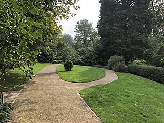
Tenbosch Park, Tenbosch or Tenbos, is a public park in the municipality of Ixelles in Brussels, Belgium. Although relatively small with an area of 2 ha, it is a landscaped park popular among local residents. It is surrounded by a wall and offers an unexpected oasis of calm in a busy district.

<span class="mw-page-title-main">Ixelles Ponds</span> Park in Ixelles, Belgium

The Ixelles Ponds or Elsene Ponds are two freshwater ponds in the Brussels municipality of Ixelles, Belgium. The ponds we can see today are those spared by a 19th-century campaign of drying the wetlands of the Maelbeek valley between La Cambre Abbey and the Place Eugène Flagey/Eugène Flageyplein.

<span class="mw-page-title-main">Fortifications of Brussels</span> Former city walls in Brussels, Belgium

The Fortifications of Brussels refers to the medieval city walls that surrounded Brussels, Belgium, built primarily to defend the city but also for administrative reasons. There were two stages of fortifications of Brussels: the first walls, built in the early 13th century, and the second walls, built in the late 14th century and later upgraded. In the 19th century, the second walls were torn down and replaced with the Small Ring, a series of boulevards bounding the historical city centre. Nowadays, only a few sections of each walls remain, most notably the Halle Gate.

<span class="mw-page-title-main">Jean de Selys Longchamps</span> Belgian fighter pilot (1912–1943)

Baron Jean Michel P.M.G. de Selys Longchamps DFC was a Belgian aristocrat and RAF fighter pilot during World War II. He is chiefly known for his single-handed attack on the Gestapo headquarters in Brussels in German-occupied Belgium.

The Greater Ring or Intermediate Ring in Brussels, Belgium is a set of roads in the shape of a ring, intermediate between the Small Ring and the main Brussels Ring motorway. The greater part of this set of roads is numbered R21 and is about 30 km long, compared to 8 km for the Small Ring and 80 km for the main Ring.

The Brussels tram route 23 was a Brussels tram route operated by STIB/MIVB in Brussels, Belgium. It ran between Vanderkindere, which was also the terminus for tram route 24 and where passengers could commute with tram routes 3, 4 and 92, and the Heysel/Heizel metro station, which offers transit with the Brussels metro line 6, tram route 51 and bus routes 84 and 88. Since March 14, 2011 the newly formed tram 7 follows the same route as tram 23, but with a much higher frequency. Because of the frequency being brought up to 'metro' level, its line number was altered to the lower regions, for those are the metro and so-called 'Chrono' tramlines. Tram 24 was also taken over completely by the newly formed tram 7.

<span class="mw-page-title-main">Brussels tram route 81</span> Tram route in Brussels, Belgium

Tram route 81 in Brussels, Belgium, is a tram route operated by STIB/MIVB, which connects the Marius Renard stop in the municipality of Anderlecht with the multimodal Montgomery metro station in Woluwe-Saint-Pierre. The route also crosses the municipalities of Saint-Gilles, Ixelles, the City of Brussels and Etterbeek. It connects with the Metro at Saint-Guidon/Sint Guido, Brussels-South, Merode and Montgomery. The route also crosses the major tram routes 3 and 4 at Horta. A good deal of its length is in carriageway, while long sections at either end are in reservation. It has a short section in tunnel at Brussels-South.

<span class="mw-page-title-main">Villa Empain</span> Art Deco building in Brussels, Belgium

The Villa Empain is a former private residence in Brussels, Belgium, which currently serves as a cultural centre and exhibition space. Built in 1930–1934 in Art Deco style by the Swiss-Belgian architect Michel Polak, the villa was commissioned by Baron Louis Empain, son of the industrialist Édouard Empain. It subsequently served as offices and an embassy before falling into disuse. After a restoration from 2009 to 2011, it was opened to the public by the Boghossian Foundation.

<span class="mw-page-title-main">Timeline of Brussels</span>

The following is a timeline of the history of Brussels, Belgium.

<span class="mw-page-title-main">The Hotel Brussels</span> Hotel in Brussels, Belgium

The Hotel Brussels is a four-star hotel in the Louise/Louiza district of Brussels, Belgium, owned and managed by the Swedish hotel group Pandox AB. A landmark building, it originally opened as the Brussels Hilton in 1969. Pandox AB purchased the building in September 2010, assumed management in February 2011 and commenced a complete renovation of the 27 floors. The renovations were completed after a two-year period.

<span class="mw-page-title-main">Namur Gate</span> Former city gate and current neighbourdhood in Brussels, Belgium

The Namur Gate was one of the medieval city gates of the second walls of Brussels, Belgium. Built in the 14th century, it was demolished in 1784 during the construction of the Small Ring.

<span class="mw-page-title-main">Avenue Franklin Roosevelt</span> Thoroughfare in Brussels, Belgium

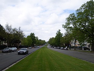
The Avenue Franklin Roosevelt (French) or Franklin Rooseveltlaan (Dutch) is an avenue in Brussels, Belgium. It is located in the southern part of the City of Brussels, near the border with the municipality of Ixelles, where it runs parallel to the Bois de la Cambre/Ter Kamerenbos. It is named in honour of the 32nd President of the United States, Franklin Delano Roosevelt.

<span class="mw-page-title-main">Chaussée de Waterloo</span> Thoroughfare in Brussels, Belgium

The Chaussée de Waterloo or Waterloosesteenweg (Dutch), is a long north–south arterial road from Brussels to Waterloo, Belgium. It begins at the Halle Gate in the Brussels municipality of Saint-Gilles, continues a course towards the south-east until the Bascule area of Uccle, then turns south in the direction of Waterloo, where it changes its name to become the Chaussée de Bruxelles and continues in the direction of Genappe and Charleroi (Wallonia) until the regional border. Its length is 12.4 kilometres (7.7 mi) and its width between 15 and 18 metres.

References

Citations

  1. "Line 8 to ROODEBEEK - STIB Mobile". m.stib.be. Retrieved 8 January 2022.
  2. "Line 93 to STADE - STIB Mobile". m.stib.be. Retrieved 9 January 2022.
  3. 1 2 3 "Avenue Louise 347 Louizalaan" (in French). Retrieved 4 February 2009.
  4. "Résidence Belvédère Avenue Louise 453" (in French). Retrieved 9 February 2009.[ dead link ]
  5. 1 2 "Baron Jean De Selys Longchamps". Archived from the original on 29 December 2008. Retrieved 4 February 2009.
  6. "Les Territoires de la Mémoire: Triangle rouge: visite" (in French). Archived from the original on 14 December 2007. Retrieved 4 February 2009.
  7. "Westminster College Welcomes Veterans Day "Speaker of Freedom"". Archived from the original on 4 June 2011. Retrieved 4 February 2009. She was moved to several prisons including '347 Avenue Louise,' Gestapo torture headquarters, where she was interrogated and tortured with beatings and experiments.
  8. "Former Gestapo Headquarters - 453 Avenue Louise" . Retrieved 4 February 2009.
  9. Helm, Sarah (26 November 1996). "Gays under pressure in Belgium's moral backlash Anger over child". The Independent. Retrieved 1 February 2019.
  10. "Brussels bans prostitution again in bid to curb Covid-19 infection rate". www.thebulletin.be. 29 September 2020. Retrieved 11 September 2021.
  11. "Council of State overturns Brussels prostitution ban". The Brussels Times. 14 October 2020. Retrieved 11 September 2021.
  12. La saga du goulet Louise Archived 12 November 2006 at archive.today - EuroBRU.com - Retrieved 12 July 2007.

Bibliography