
Monroe County is a county in the U.S. state of Indiana. In 1910 the US Census Bureau calculated the nation's mean population center to lie in Monroe County. The population was 139,718 at the 2020 United States Census. The county seat is Bloomington. Monroe County is part of the Bloomington, Indiana, Metropolitan Statistical Area.

Bedford is a city in Shawswick Township and the county seat of Lawrence County, Indiana, United States. In the 2020 census, the population was 13,792. That is up from 13,413 in 2010. Bedford is the principal city of the Bedford, IN Micropolitan Statistical Area, which comprises all of Lawrence County.

Bloomington is a city in and the county seat of Monroe County, Indiana, United States. The population was 79,168 at the 2020 census. It is the seventh-largest city in Indiana and the fourth-largest outside the Indianapolis metropolitan area. It is the home of Indiana University Bloomington, the flagship campus of the IU System. Established in 1820, IU Bloomington enrolls over 45,000 students.

Brownfield refers to land that is abandoned or underutilized due to pollution from industrial use. The specific definition of brownfield land varies and is decided by policy makers and/or land developers within different countries. The main difference in definitions of whether a piece of land is considered a brownfield or not depends on the presence or absence of pollution. Overall, brownfield land is a site previously developed for industrial or commercial purposes and thus requires further development before reuse.

Indiana University Bloomington is a public research university in Bloomington, Indiana. It is the flagship campus of Indiana University and its largest campus with over 40,000 students. Established as the state's seminary in 1820, the name was changed to "Indiana College" in 1829 and to "Indiana University" in 1838.

The Monon Railroad, also known as the Chicago, Indianapolis, and Louisville Railway from 1897 to 1971, was an American railroad that operated almost entirely within the state of Indiana. The Monon was merged into the Louisville and Nashville Railroad in 1971, and much of the former Monon right of way is owned today by CSX Transportation. In 1970, it operated 540 miles (870 km) of road on 792 miles (1,275 km) of track; that year it reported 1320 million ton-miles of revenue freight and zero passenger-miles.
The Atlanta BeltLine is a 22 miles (35 km) open and planned loop of multi-use trail and light rail transit system on a former railway corridor around the core of Atlanta, Georgia. The Atlanta BeltLine is designed to reconnect neighborhoods and communities historically divided and marginalized by infrastructure, improve transportation, add green space, promote redevelopment, create and preserve affordable housing, and showcase arts and culture. The project is in varying stages of development, with several mainline and spur trails complete and others in an unpaved, but hikeable, state. Since the passage of the More MARTA sales tax in 2016, construction of the light rail streetcar system is overseen by MARTA in close partnership with Atlanta BeltLine, Inc.

Three Rivers Park District is a special park district serving the suburban areas of the Twin Cities including suburban Hennepin, Carver, Dakota, Scott, and Ramsey counties. Three Rivers's mission is "To promote environmental stewardship through recreation and education in a natural resources-based park system." Three Rivers operates twenty parks and ten regional trails, with at least two more regional trails planned. Nearly seven million people visit Three Rivers facilities each year. It has over 27,000 acres (11,000 ha) of parks and trails.

The Cape Cod Rail Trail (CCRT) is a 25.5-mile (41.0 km) paved rail trail located on Cape Cod in Massachusetts. The trail route passes through the towns of Yarmouth, Dennis, Harwich, Brewster, Orleans, Eastham, and Wellfleet. It connects to the 6-plus mile (10 km) Old Colony Rail Trail leading to Chatham, the 2 mile Yarmouth multi-use trail, and 8 miles (13 km) of trails within Nickerson State Park. Short side trips on roads lead to national seashore beaches including Coast Guard Beach at the end of the Nauset Bike Trail in Cape Cod National Seashore. The trail is part of the Claire Saltonstall Bikeway.

Hackensack River Greenway, once known as the Hackensack RiverWalk, a is partially constructed greenway along the Newark Bay and Hackensack River in Hudson County, New Jersey, United States.
Transportation in Indianapolis consists of a complex network that includes a local public bus system, several private intercity bus providers, Amtrak passenger rail service, four freight rail lines, an Interstate Highway System, an airport, a heliport, bikeshare system, 115 miles (185 km) of bike lanes, and 116 miles (187 km) of trails and greenways. The city has also become known for its prevalence of electric scooters.
Indiana University (IU) is a system of public universities in the U.S. state of Indiana.

The Ohio River Trail is composed of two trails: The Ohio Water Trail and the Ohio River Greenway Trail. The Ohio River Greenway Trail (ORGT) is a proposed route that would interconnect existing trails in Maryland, Pennsylvania, Ohio and West Virginia. The proposal is spearheaded by the Ohio River Trail Council (ORTC), a volunteer-led, non-profit organization. The ORTC is an Internal Revenue Service registered 501(c)(3) not-for-profit organization which relies on corporate, foundation, government, and private grants and donations to achieve its stated mission of creating a multi-use trail along the Ohio River and its tributaries. The Council is headquartered in Monaca, Pennsylvania.

Pittsburgh is a neighborhood of Atlanta, Georgia, founded in 1883 as a Black working-class suburb alongside the Pegram rail shops. It was named Pittsburgh because the industrial area reminded one of Pittsburgh, Pennsylvania and its famous steel mills. Pittsburgh is a working class and developing neighborhood, and as property values rise in Intown Atlanta neighborhoods, many see possibility that this trend will spread to Pittsburgh while bringing renewal for legacy residents.
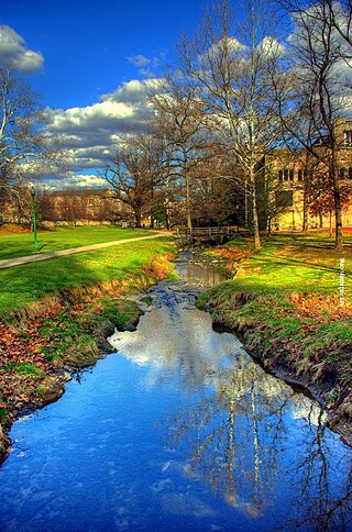
Clear Creek is an American creek in Monroe County, Indiana. Flowing in the general south-western and southern direction, it is a tributary of Salt Creek, which in its turn flows into the East Fork of Indiana's White River.
Newark Riverfront Park is a park and promenade being developed in phases along the Passaic River in Newark, New Jersey, United States. The park, expected to be 3 miles (4.8 km) long and encompass 30.5 acres (12.3 ha), is being created from brownfield and greyfield sites along the river, which itself is a Superfund site due to decades of pollution. It will follow the river between the Ironbound section along Raymond Boulevard and Downtown Newark along McCarter Highway. Announced in 1999, a groundbreaking took place in 2008, and the first phase of the park opened in 2012. It was the first time residents of the largest city in New Jersey have ever had public access to the river. Other segments of the park have subsequently opened, while others are being developed. The East Coast Greenway uses paths and roads along the park.
Bloomington Rail Trail is a 2-mile multi-use gravel path in Bloomington, Indiana. It connects with the B-Line Trail at Country Club Drive and Clear Creek Trail at Church Lane. Benches and a drinking fountain are located at the intersection with Country Club Drive intersection. Trailheads are located on Country Club Drive, Tapp Road, That Road, and Church Lane. Trees border much of the trail used by runners, walkers and cyclists. In March 2018, the city of Bloomington closed a portion of the trail for several days in order to remove invasive species of plants.

Chevy Commons is a park along the Flint River between Kettering University and downtown Flint, Michigan. Formerly the site of a Chevrolet factory widely known as "Chevy in the Hole", it has been redeveloped and revitalized since 2015 as event space and recreational areas with restored grasslands, meadows, wetlands, and woodlands. It also features green spaces, low-maintenance native plants, and walking trails. In total, the creation of Chevy Commons is expected to cost approximately $17.3 million, and it is part of a broader, $36.8-million project to change the landscape of the Flint River in Downtown Flint. The state of Michigan has committed to developing the site as a state park.
The Djerring Trail is a shared use path that runs alongside the Cranbourne and Pakenham railway lines in south-eastern Melbourne, Australia. The route serves a total of 13 railway stations.
