Oku is a subdivision in North West Region,, Cameroon. The term Oku also refers to the people who live in this region and the primary language that they speak. Oku is a rural area containing about 36 villages. The nearest really large city is Bamenda, but Kumbo, which is closer, is large enough to have telephone lines and a Baptist-run hospital. Oku also has a Sub-divisional hospital. However, three mobile telephone networks are available in Oku. As such, mobile internet facilities are available.
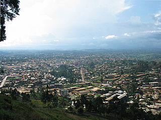
Bamenda, also known as Abakwa and Mankon Town, is a city in northwestern Cameroon and capital of the Northwest Region. The city has a population of about 2 million people and is located 366 kilometres (227 mi) north-west of the Cameroonian capital, Yaoundé. Bamenda is known for its cool climate and scenic hilly location.

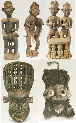
The Bamileke are a Central African people who inhabit the Bamenda Grassfields of Cameroon. They speak a Southern Bantoid language within the Bamileke language group.

Bafut is a town located in a modern commune in Cameroon, it is also a traditional fondom. It is located in the Mezam Department, which in turn is located in the Northwest Province.

Mankon is a geo-historic community constituting a large part of Bamenda in Cameroon, formed as an amalgamation of about five different ethnic groups. The Mankon fondom (kingdom) represents one of the oldest monarchies of the grassfield people of the Northwest Province. The fondom is ruled by a fon (king) with rights to kinghood acquired by birth. The crowned fon is usually a designated son of the deceased king, a child who was born only during his reign.
The Fon of Bafut is the fon or Mfor of the town of Bafut and its adjoining areas in the Northwest Province, Cameroon, which comprise the erstwhile Fondom of Bafut. At present, the Fon of Bafut is still a local ruler, but under the jurisdiction of the Government of Cameroon, and a board of Fons. Bafut is one of the largest villages in the North West Province.
The Kom are one of the principal ethnic groups of the North-West province of Cameroon, where traditional government institutions are very important. The capital, Laikom, is the seat of the ruler, the Fon, and his advisors, the Quifon, who continue to be the most respected leaders despite the imposition of a central Cameroonian government. Vincent Yuh II died in November 2017, Fon Ndzi II is the current Fon of Kom. The Cameroonian government recognizes to some degree the authority of the Fons and local chiefs subject to them.
The Vengo, or Babungos, are an ethnic group of about 14,000 people who are resident in the anglophone Northwest Province of Cameroon. They live predominantly in the region of a village which is also called Vengo or "Babungo". This village is located in the Cameroonian Grassfields at the so-called "Ringroad", approximately 50 km West of the province's capital Bamenda. The language of the people is also called Vengo or "Babungo". For the tribe, village and language the spelling "Bamungo" is also often found.
Mbengwi is the headquarters of Momo Department in the Northwest Region of Cameroon, located some 22 km from Bamenda.

The Tikar are a central African people who inhabit the Bamenda Grassfields in Cameroon. They are known as great artisans, artists and storytellers. Once a nomadic people, oral tradition traces the origin of the Tikar people to the Nile River Valley. They speak a Northern Bantoid language called Tikar. The current population of Tikar in Cameroon is approximately 168,000-173,000. This is a great difference from other trafficked ethnic groups like the Kirdi, who still number around 15 million people.
The Nso are a people of the Bamenda grass fields Northwest Region of Cameroon. Their traditional language is Lamnso and their capital is Kumbo – where the Palace of the Fon is found.
The Bafut Subdivision or the Kingdom/Chiefdom/Fondom of Bafut is a commune in the Mezam Department of Northwest Province, Cameroon. It is located in the Western Grassfields region - a name for the Northwest Province and surrounding grassland areas. Bafut is the most powerful of the traditional kingdoms of the Grassfields, now divided into 26 wards along a 10 kilometre stretch of the "Ring Road" that trails along a ridge above the Menchum Valley.
Chomba is a village under the Bamenda municipality in Cameroon. The village is located six kilometers outside of Bamenda town. Before the 1960s, no motorable road linked the village to Bamenda town. The main road that links the village to the town was constructed manually by the villagers themselves. It was until the late 1970s/early 1980s that motor vehicles could reach the village. Today, the village is linked to the Bamenda town, by a half-tarred/half-untarred road.
Bamunka is a small village of Cameroon located in the North West Region along the ring road from Bamenda. Bamunka Village is the Sub Divisional Headquarter of Ndop Central Subdivision and the Divisional Headquarter of Ngoketunjia Division.

Bambalang is a village located in the NorthWest Region of Cameroon. The village of Bambalang is one of the four villages that make up Ndop Central Sub Division and one of the thirteen villages that make up Ngoketunjia Division. Bambalang village saw most of its fertile land flooded upon the completion of the Bamendjin Dam in 1974 giving rise to some Islands like Mbissa, Nkeshie, Mbefekhu, Mishie and Mpayah. The Bamendjin Dam was constructed mainly to serve as a reservoir to feed the hydroelectric plant at Edéa. It was constructed across the Noun River, a tributary of the Sanaga River that operates the hydroelectric plant at Edea. The construction of this dam has served as a source of mixed feelings for Bambalang people because while those whose fertile land were flooded look at it as a mishap, it is beneficial to a cross section of the population given that it is contributing enormously to the economy of the village with thousands of fishermen whose lives and that of their families depend on fish gotten from the water. The vegetation is Guinea Savanna as farming has destroyed most forests with the exception of the "Pa’ah Ngwong" Forest at the heart of the village. Bambalang village is mainly a hillock stretching in a North West, South-East direction. It is narrow at the North-West and broadens towards the South East, appearing as a semi-Island or a promontory. Bambalang has a length of about 21 km and a width of about 8 km giving an area of about 168 km2 supporting a population of 20.863 people.

Balikumbat is a village located in Balikumbat Sub Division, Ngoketunjia Division of the North West Region, Cameroon. Balikumbat is the Sub Divisional Headquarter of Balikumbat Sub Division and located about 20.9 km from Ndop town.

Bamessing village is one of four villages that make up Ndop central Central Sub Division, and one of thirteen villages of Ngoketunjia division of the North West region of Cameroon. Bamessing is located along the ring road from Bamenda, some 38 km from the town of Bamenda, on the Bamenda-Nkambe stretch of the ring road, just before Bamunka.
Bamali village is one of the four villages that make up Ndop Central sub division and one of the thirteen villages of Ngoketunjia division of the North West region of Cameroon. Bamali village is located partly along the ring road from Bamenda some 40 km away from Bamenda town on the Bamenda-Nkambe stretch of the ring road just before reaching Bamunka.
Baba I village (Papiakum) is one of the four villages that make up Babessi subdivision and one of the thirteen villages of Ngoketunjia division of the North West region of Cameroon. Baba I village is located along the ring road from Bamenda some 50 km away from Bamenda town on the Bamenda-Nkambe stretch of the ring road just before one reaches Bamunka.
This is a timeline of the Anglophone Crisis during 2020.