Bad Endbach

Last updated
Bad Endbach
Panorama bad endbach 20030529.jpg
View over Bad Endbach
Wappen Bad Endbach.svg
Coat of arms
Location of Bad Endbach within Marburg-Biedenkopf district
Marburg-Biedenkopf Bad Endbach.png
Germany adm location map.svg
Red pog.svg
Bad Endbach
Hesse location map.svg
Red pog.svg
Bad Endbach
Coordinates: 50°45′N8°30′E / 50.750°N 8.500°E / 50.750; 8.500 Coordinates: 50°45′N8°30′E / 50.750°N 8.500°E / 50.750; 8.500
Country Germany
State Hesse
Admin. region Gießen
District Marburg-Biedenkopf
Subdivisions8 Ortsteile
Government
   Mayor (201723) Julian Schweitzer [1] (SPD)
Area
  Total39.84 km2 (15.38 sq mi)
Elevation
300 m (1,000 ft)
Population
 (2020-12-31) [2]
  Total8,001
  Density200/km2 (520/sq mi)
Time zone UTC+01:00 (CET)
  Summer (DST) UTC+02:00 (CEST)
Postal codes
35080
Dialling codes 02776
Vehicle registration MR
Website www.bad-endbach.de

Bad Endbach is the westernmost municipality in Marburg-Biedenkopf district of the state of Hesse in Germany, and borders on the Lahn-Dill district.

Contents

Geography

Location

Bad Endbach lies in the Lahn-Dill Bergland (ie Highland) in the foothills of the Rothaargebirge and Westerwald mountain ranges in a changeable low mountain range landscape between the towns of Marburg and Herborn.

Within the community's territory, in the Hartenrod area, rises the brook known as the Salzböde, along which stretches much of the municipal area.

Geology

Geologically, the area belongs mainly to the Devonian and Culm formation in which slate, greywacke and diabase predominate.

Neighbouring communities

Clockwise from the north, the following towns and communities border on the community of Bad Endbach:

The communities of Angelburg, Steffenberg and Dautphetal lie to the northwest, north and northeast respectively. Next, to the east, comes the town of Gladenbach. All these municipalities lie, like Bad Endbach itself, in Marburg-Biedenkopf district. Further, there is the community of Bischoffen in the south and the community of Siegbach in the west, both of which belong to the Lahn-Dill district.

Community divisions

Bad Endbach's municipal area is divided into eight constituent communities.

CommunityDescription
BottenhornWith about 1350 inhabitants it is the third biggest constituent community. Bottenhorn was first mentioned in 1302 in a document from the Altenberg Monastery. Historic names: 1304 Botinhorne, 1324 Buttinhorn, 1491 Bettehorn, 1502 Bottenhorn
DernbachHistoric names: 1255 Derinbach, 1363 Therinbach, 1398 Derenbach, 1411 Dernbach.
EndbachMain centre and second biggest constituent community lying at the forks where the Endebach empties into the Salzböde. Historic names: 1261 Endebach, 1577 Ennebach
GünterodHistoric names: 1294 Gunterode, 1343/47 Günterrode, 1416 Günterade, 1479 Gonterodde, 1502 Gunteroide, 1564 Günterode
HartenrodWith 2504 inhabitants (1997) the biggest constituent community. Hartenrod was first mentioned in 1364. Historic names: 1364 Harterode, 1380 Harprachterode, 1397 Hartenrade, 15. Jhd. Hirtprachterode, 1466 Hartenrode, 1502 Harteroide, 1630 Hartenroda.
HülshofWith about 20 inhabitants, living in five houses, the smallest constituent community. Der Hülshof was first mentioned in 1284. Historic names: 1284 Hulsbahc, 1304 Halespecher marca, 1304 Hulisbach, 1344 Hultzpach, 1354 Hulzbach, 1397 Holspach, 1630 Hulß Hoff
SchlierbachAbout 420 inhabitants. Schlierbach was first mentioned in 1318 as Slirbach (Slir-Lehm). A brook of the same name flows through the little village. Historic names: 1318 Slirbach, 1359 Sclirbach, 1448 Slierbach, 1630 Schlirbach
WommelshausenAbout 950 inhabitants. Wommelshausen was first mentioned on 10 August 1336. Historic forms of the name: 1336, a double village called Womoldishusin superior et inferior (ie Upper and Lower Womoldishusin); 1340, Syvret von Womulshusen (a lay judge's name); undated, Wommeldishoffen; 1400, Waneboltshusen; 1500, Womelshusenn; 1536, Wumolzhusen; 1707, Womelshausen. Name comes from Frankish given name Womhold or Wombold, and therefore means "settlement at Wombold's house".

The village is clearly older than the first mention, as the chapel (mentioned below) had already undergone remodelling in 1268. The community of Hütte also belongs to Wommelshausen. Once wholly confined to Wommelshausen's rural area, it has now also swallowed up 80% of Endbach's rural area, too. It was first mentioned in 1586 under the name "uf der Hütten", and later in 1703 as "Die Hütte". This community is not the same one as the former Unterwommelshausen. It is newer and can be traced back to an ironworks here in the late Middle Ages.

History

Viaduct on the Aar-Salzbode railway in Hartenrod Viadukt bad endbach 20040528.jpg
Viaduct on the Aar-Salzböde railway in Hartenrod

Amalgamations

On 1 February 1971, the two communities of Endbach and Wommelshausen combined into one community of Endbach, and likewise the two communities of Hartenrod and Schlierbach did the same on 31 December of the same year, taking the former's name. On 1 April 1972, Günterod was amalgamated with Endbach, before in the end, on 1 July 1974, as a result of municipal reform in Hesse, Endbach and Hartenrod were not only amalgamated with each other, but also with Bottenhorn, Dernbach and Hülshof to form the new community of Bad Endbach.

Politics

Municipal council

As of municipal elections on 6 March 2016 and formerly on 27 March 2011, respective on 26 March 2006, municipal council seats are apportioned thus: [3] [4] [5]

Parties and voting blocks %
2016
Seats
2016
 %
2011
Seats
2011
 %
2006
Seats
2006
SPD Social Democratic Party of Germany 42.61037.8935.511
CDU Christian Democratic Union 36.3840.11036.011
FWGFreiwillige Wählergemeinschaft (citizens' coalition)21.1518.3522.57
UBLUnabhängige Bürgerliste Bad Endbach (Independent citizens' list)3.816.02
Total100231002510031
Turnout in %40.539.136.6

Coat of arms

The municipal arms might be described thus: In vert six bendlets sinister wavy argent; above a sun Or; below a watering can Or.

Town partnerships

Culture and sightseeing

In Wommelshausen stands a noteworthy old chapel of Romanesque origins that was apparently remodelled or renovated in the 13th century in the early Gothic style. It is said to be an important historic building as it has hardly changed over the ages. Timbers found in the demonstrably remodelled east gable come from the year 1268 (the year that they were felled). The building that stands today is, however, much older, likely by as much as 200 or 250 years. During renovation work, clues were found on the south side in the inner room to an earlier building. This earlier building might have been a wooden church on a stone foundation, and might have been built in the time of the Irish-Scottish mission in the area. Irish-Scottish missionaries were active in the vicinity even before Saint Boniface, as digs at the Büraburg Monastery prove (as do those at, among others, Wetter and the Christenberg). The building standing today might have been built under the influence of the Worms Bauhütte (a forerunner to the later guilds), as it bears a keen likeness to the rather bigger Magnus-Kirche (church) in Worms. The Bishopric of Worms once had vast holdings throughout the area.

Two small, high windows on the building's south side have round frames inside, but oddly squeezed, peaked frames on the outside, a sure sign of remodelling. The former priest's entrance in the south front wall is definitely Romanesque. The layman's entrance lies on the north side underneath the later enlarged window. In the west wall is found a further window. The chapel once had an oblong choir which was broken up and its opening walled up in the 18th century. Measurements of the building's inner dimensions yield a width of about 6.95 m and a length of about 10.15 m. The walls are about 1.2 m thick. The builders, however, used a "foot", believed to average about 33 cm long to do their measurements. The building stones were boulders, greywacke, on rich beds of mortar. There are no hewn stones. The inner room is a plain chamber. The building has a ridge turret as a bell tower. It never had a steeple like other churches in the area. These are the main things that set the building apart from others in the area. The inner room is further an example of one of the earliest galleries in the whole area.

The chapel is said to have once been built over a spring. Its location at the lowest place in the village lends weight to this story. It was supposedly a chapel to Saint Mary before the Reformation, and served as a pilgrimage site because of the spring, which was said to work wonders, and which was said to have come forth from under the choir. There is a pleasant anecdote about this.

Christian communities

DenominationCentre
Evangelical ChurchBad Endbach / Bottenhorn / Günterod / Hartenrod / Wommelshausen
Free Evangelical Community Bad Endbach / Günterod / Hartenrod-Schlierbach / Wommelshausen
Catholic ChurchHartenrod
Ev. Gemeinschaft e.V. and Christian Endeavour Youth Association Hartenrod
Christian Assembly ("Open Brethren")Bad Endbach / Günterod
Christian Assembly ("Closed Brethren")Dernbach / Günterod
Plymouth Brethren IV ("Exclusive Brethren")Bad Endbach

Regular events

Easter hiking week, Whitsun hiking week, Health days, Music days, Autumn hiking week, Sinnlos youth evangelization .

Economy and infrastructure

Bad Endbach earns its livelihood overridingly from its spa business and tourism. There are no big companies operating in the community.

Spas

Bad Endbach offers an extensive network of hiking trails, a choice of specialized offerings for migraine therapy and vein treatments as well as clinical aftercare.

Related Research Articles

Lahn-Dill is a Kreis (district) in the west of Hesse, Germany. Neighboring districts are Siegen-Wittgenstein, Marburg-Biedenkopf, Gießen, Wetteraukreis, Hochtaunuskreis, Limburg-Weilburg, Westerwaldkreis.

Marburg-Biedenkopf is a Kreis (district) in the west of Hesse, Germany. Neighboring districts are Waldeck-Frankenberg, Schwalm-Eder, Vogelsbergkreis, Gießen, Lahn-Dill, Siegen-Wittgenstein.

Wetter, Hesse Place in Hesse, Germany

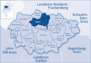
Wetter (Hessen) is a small town in Hesse, Germany. The rather unusual designation Wetter (Hessen-Nassau) stems from a time when the town belonged to the Prussian province of the same name, and nowadays is only used by the railway – even today, the railway station in town bears this name.

Hatzfeld Place in Hesse, Germany

Hatzfeld (Eder) is a small town in Waldeck-Frankenberg district in Hesse, Germany.

Dautphetal Place in Hesse, Germany

Dautphetal is a community in Hesse, Germany, and is among the six larger communities of the 22 in Marburg-Biedenkopf district.

Lahntal Place in Hesse, Germany

The community of Lahntal is found in the Marburg-Biedenkopf district in northwest Middle Hesse, Germany.

Leun Place in Hesse, Germany

Leun is a small town in the Lahn-Dill-Kreis in Hesse, Germany.

Eschenburg Place in Hesse, Germany

Eschenburg is a community in the Lahn-Dill-Kreis in Hesse, Germany. The community inherited its name from nearby Eschenburg mountain.

Amöneburg Place in Hesse, Germany

Amöneburg is a town in the Marburg-Biedenkopf district in Hesse, Germany. It lies on a mountain and is built around the castle of the same name, Burg Amöneburg.

Angelburg Place in Hesse, Germany

Angelburg is a community in western Marburg-Biedenkopf in northwest Middle Hesse in Germany.

Biedenkopf Place in Hesse, Germany

Biedenkopf is a spa town in western Hesse, Germany with a population of 13,588.

Breidenbach Place in Hesse, Germany

Breidenbach is a community in the west of Marburg-Biedenkopf district in Hesse, Germany.

Ebsdorfergrund Place in Hesse, Germany

Ebsdorfergrund is a community consisting of eleven villages in the southeast of Marburg-Biedenkopf district in Hesse, Germany.

Weimar (Lahn) Place in Hesse, Germany

Weimar is a community in the south of Marburg-Biedenkopf district in Gießen administrative region, Hesse, Germany. The community's administrative seat is the centre of Niederweimar.

Gladenbach Place in Hesse, Germany

Gladenbach [German pronunciation: [ˈɡlaːdn̩ˌbax](listen)] is a town in Hesse, Germany, in the west of Marburg-Biedenkopf district.

Cölbe Place in Hesse, Germany

Cölbe is a community in Marburg-Biedenkopf district in Hesse, Germany.

Steffenberg Place in Hesse, Germany

Steffenberg is a community in Marburg-Biedenkopf district in Hesse, Germany.

Bischoffen Place in Hesse, Germany

Bischoffen is a community in the Lahn-Dill-Kreis in Hesse, Germany.

Burgwald Place in Hesse, Germany

Burgwald is a community in Waldeck-Frankenberg in Hesse, Germany.

Hessian Hinterland

The land known as the Hessian Hinterland lies within the region of Middle Hesse and is concentrated around the old county of Biedenkopf, that is the western part of the present county of Marburg-Biedenkopf, as well as elements of the present-day counties of Lahn-Dill-Kreis and Waldeck-Frankenberg. Formerly it snaked its way from Bromskirchen in the north to Rodheim, in the municipality of Biebertal.

References

  1. Direkt gewählte (Ober-) Bürgermeister/-innen der hessischen Städte und Gemeinden, accessed 5 July 2021.
  2. "Bevölkerung in Hessen am 31.12.2020 nach Gemeinden". Hessisches Statistisches Landesamt (in German). June 2021.
  3. 2016-Hessisches Statistisches Landesamt (in german)
  4. 2011-Hessisches Statistisches Landesamt (in german)
  5. 2006-Hessisches Statistisches Landesamt (in german)