Bad Schwalbach

Last updated
Bad Schwalbach
Gesamtanlage Gartenfeldstrasse - 1.JPG
A residential area in Bad Schwalbach
Wappen Bad Schwalbach.png
Location of Bad Schwalbach within Rheingau-Taunus-Kreis district
Bad Schwalbach in RUD.svgHohenstein
Germany adm location map.svg
Red pog.svg
Bad Schwalbach
Hesse location map.svg
Red pog.svg
Bad Schwalbach
Coordinates: 50°08′N08°04′E / 50.133°N 8.067°E / 50.133; 8.067 Coordinates: 50°08′N08°04′E / 50.133°N 8.067°E / 50.133; 8.067
Country Germany
State Hesse
Admin. region Darmstadt
District Rheingau-Taunus-Kreis
Subdivisions8 districts
Government
   Mayor (201925) Markus Oberndörfer [1] (SPD)
Area
  Total40.27 km2 (15.55 sq mi)
Elevation
361 m (1,184 ft)
Population
 (2020-12-31) [2]
  Total11,207
  Density280/km2 (720/sq mi)
Time zone UTC+01:00 (CET)
  Summer (DST) UTC+02:00 (CEST)
Postal codes
65307
Dialling codes 06124
Vehicle registration RÜD, SWA
Website www.bad-schwalbach.de

Bad Schwalbach (called Langenschwalbach until 1927) is the district seat of Rheingau-Taunus-Kreis, in Hesse, Germany.

Contents

Geography

Geographic location

Bad Schwalbach is a spa town some 20 km northwest of Wiesbaden. It lies at 289 to 465 m above sea level in the Taunus, along the small river Aar (Lahn) (a tributary of the Lahn). Over 56 percent of the municipal area is forest.

Neighbouring communities

Bad Schwalbach borders in the north on the community of Hohenstein, in the east on the town of Taunusstein, in the south on the community of Schlangenbad, and in the west on the community of Heidenrod.

Constituent communities

Bad Schwalbach’s Stadtteile are Adolfseck, Bad Schwalbach, Fischbach (Bad Schwalbach), Heimbach, Hettenhain, Langenseifen, Lindschied and Ramschied.

History

Map of Langenschwalbach in 1728 Langenschwalbach.jpg
Map of Langenschwalbach in 1728
Bad Schwalbach - Extract from Topographia Hassiae by Matthaus Merian the Younger, 1655 Bad Schwalbach De Merian Hassiae.jpg
Bad Schwalbach – Extract from Topographia Hassiae by Matthäus Merian the Younger, 1655
Bad Langenschwalbach about 1900 Bad Langenschwalbach 1900.jpg
Bad Langenschwalbach about 1900
Bad Schwalbach about 1832 in an engraving after Tombleson Tombleson Schwalbach.jpg
Bad Schwalbach about 1832 in an engraving after Tombleson
Bad Langenschwalbach about 1900 Bad Langenschwalbach 2 1900.jpg
Bad Langenschwalbach about 1900
Bond of the City of Langenschwalbach, issued 1. March 1880 for the building of a school, a pump room and a mortuary. Stadt Langenschwalbach 1880.jpg
Bond of the City of Langenschwalbach, issued 1. March 1880 for the building of a school, a pump room and a mortuary.

Bad Schwalbach was first mentioned in a document in 1352 as Langinswalbach. The first reliable report of the mineral springs came in 1568 from the Worms doctor Tabernaemontanus , who also made the place known in his 1581 work Neuw Wasserschatz (New Water Resources). Although Langenschwalbach was utterly destroyed in the Thirty Years' War, it was quickly rebuilt, and the healing water trade began to blossom. At first, the water would be sold by the jug or barrel throughout Europe by mail order. Only a few seekers of healing undertook the arduous journey to the Taunus.

The health resort started at the beginning of the 19th century only after the improvement of road conditions through construction. The Aartalbahn (railway) from Wiesbaden to Langenschwalbach, finished in 1889, also contributed substantially to its founding. Many crowned heads, princes and counts then came to take the waters and visit the gaming parlours where few strict rules applied. After the end of the First World War, the nobility quickly lost importance and thus began the long, drawn-out and somewhat painful transition from a luxury spa to a public one, which only ended after the Second World War.

In a wood near Bad Schwalbach in late 1800 or early 1801, Katharina Pfeifer is said to have borne the outlaw Schinderhannes (Johannes Bückler) a child. [3]

Politics

Town council

The municipal election held on 26 March 2006 yielded the following results:

Parties and voter communities%
2006
Seats
2006
%
2001
Seats
2001
CDU Christian Democratic Union of Germany 34.11333.012
SPD Social Democratic Party of Germany 30.81132.812
GREENS Bündnis 90/Die Grünen 11.149.34
FDP Free Democratic Party 4.013.91
BSBBad Schwalbacher Bürgerblock15.8611.24
FWGFreie-Wähler-Gemeinschaft4.129.84
Total100.037100.037
Voter turnout in %46.652.4

Mayors

Culture and sightseeing

The Kurbahn, which operates on the rails of the former Moortransportbahn in the spa park, provides special access to the town’s and health resort’s history. From April to October, the trains are run by the Bad Schwalbacher Kurbahn Verein e.V. on all Sundays and holidays. From Moorbadehaus Station the line leads to the Moorgruben by way of Golfhaus, Schwalbenbrunnen and Waldsee.

Bad Schwalbach's only museum was reopened in 2002 with new exhibits. Through its exhibits, it attempts to lead visitors through Bad Schwalbach’s history and its life as a health resort. Among other things, the museum includes the pharmacy museum, once displayed in private rooms. The pharmacy museum contains the oldest pharmacy in the Taunus (established in 1642), fully furnished. The museum also houses the town archive.

Also worth seeing are the seven fountains and many temples, among them the Elisabethentempel, which was endowed by Elisabeth of Austria-Hungary (Sissi) while she was staying at the spa in Langenschwalbach. It affords a good view over the town.

North of the town is found Alexander’s Rest – so called even in German – a sheltered bench which also serves as a memorial to a British spa visitor who was killed at this spot in a bicycle accident in August 1896 (he is buried at the local cemetery).

Economy and Infrastructure

The largest employer is the Schwälbchen Molkerei Jakob Berz AG (dairy).

Transport

Bad Schwalbach lies on Bundesstraße 260, also known as the Bäderstraße (“Bath Road”), as well as Bundesstraßen 54 and 275. The nearest Autobahn interchange is on the A 66 15 km away. There is also another interchange 20 km away at Idstein on the A 3.

Bad Schwalbach also lies on the Aartalbahn, but there has been no regular passenger service since 1986, only seasonal railway-museum tours by the Nassauische Touristikbahn. Bad Schwalbach is therefore the only Hessian district seat which is no longer served by rail. There have been efforts to have the line reactivated, yet they have all been unsuccessful so far. This line has been labelled a cultural monument and is Hesse's longest building monument – only the Roman limes, a land monument, is longer.

Education

Famous people

Sons and daughters of the town

People associated with the town

The Realschule (Hufeisenschule) in what was then called Langenschwalbach was attended from 1846 to 1848 by Nicolaus Otto (1832–1891), the inventor born in nearby Holzhausen an der Haide who developed the Otto engine.

Related Research Articles

<span class="mw-page-title-main">Taunus</span> Mountain range in Germany

The Taunus is a mountain range in Hesse, Germany, located north of Frankfurt. The tallest peak in the range is Großer Feldberg at 878 m; other notable peaks are Kleiner Feldberg and Altkönig.

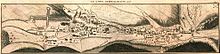
Rheingau-Taunus is a Kreis (district) in the west of Hesse, Germany. Rheingau-Taunus-Kreis is part of the Darmstadt region; its main administrative seat is Bad Schwalbach. Outposted sections of the local administration are located in Idstein and Rüdesheim am Rhein.

<span class="mw-page-title-main">Hofheim, Hesse</span> Town in Hesse, Germany

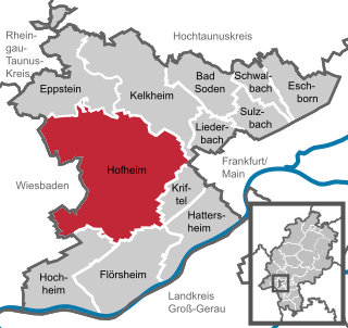
Hofheim is the administrative centre of Main-Taunus-Kreis district, in the south of the German state of Hesse. Its population in September 2020 was 39,946.

<span class="mw-page-title-main">Kronberg im Taunus</span> Town in Hesse, Germany

Kronberg im Taunus is a town in the Hochtaunuskreis district, Hesse, Germany and part of the Frankfurt Rhein-Main urban area. Before 1866, it was in the Duchy of Nassau; in that year the whole Duchy was absorbed into Prussia. Kronberg lies at the foot of the Taunus, flanked in the north and southwest by forests. A mineral water spring also rises in the town.

<span class="mw-page-title-main">Bad Ems</span> Town in Rhineland-Palatinate, Germany

Bad Ems is a town in Rheinland Pfalz, Germany. It is the administrative seat of the Rhein-Lahn rural district and is well known as a spa on the river Lahn. Bad Ems is the seat of the Verbandsgemeinde Bad Ems-Nassau. The town has around 9,000 inhabitants.

<span class="mw-page-title-main">Schmitten im Taunus</span> Municipality in Hesse, Germany

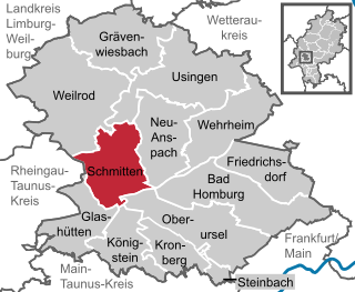
Schmitten im Taunus is a municipality in the Hochtaunuskreis in Hessen, Germany.

<span class="mw-page-title-main">Königstein im Taunus</span> Town in Hesse, Germany

Königstein im Taunus is a health spa and lies on the thickly wooded slopes of the Taunus in Hesse, Germany. The town is part of the Frankfurt Rhein-Main urban area. Owing to its advantageous location for both scenery and transport on the edge of the Frankfurt Rhine Main Region, Königstein is a favourite residential town. Neighbouring places are Kronberg im Taunus, Glashütten, Schwalbach am Taunus, Bad Soden am Taunus and Kelkheim.

<span class="mw-page-title-main">Schlangenbad</span> Municipality in Hesse, Germany

Schlangenbad is a municipality in the Rheingau-Taunus-Kreis in the Regierungsbezirk of Darmstadt in Hesse, Germany.

<span class="mw-page-title-main">Taunusstein</span> Town in Hesse, Germany

Taunusstein is the biggest town in the Rheingau-Taunus-Kreis in the Regierungsbezirk of Darmstadt in Hessen, Germany. It has 30,068 inhabitants (2020).

<span class="mw-page-title-main">Sontra</span> Town in Hesse, Germany

Sontra is a small town in the Werra-Meißner-Kreis in northeastern Hesse, Germany.

<span class="mw-page-title-main">Wiesbaden Hauptbahnhof</span> Railway station in Hesse, Germany

Wiesbaden Hauptbahnhof is a railway station for the city of Wiesbaden, the state capital of the German state of Hesse. It is a terminal station at the southern edge of the city centre and is used by more than 40,000 travelers each day, so it is the second largest station in Hesse after Frankfurt Hauptbahnhof. It is classified by Deutsche Bahn as a category 2 station.

<span class="mw-page-title-main">Aarbergen</span> Municipality in Hesse, Germany

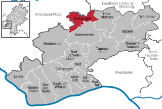
Aarbergen is a municipality in the Rheingau-Taunus-Kreis in the Regierungsbezirk of Darmstadt in Hesse, Germany.

<span class="mw-page-title-main">Heidenrod</span> Municipality in Hesse, Germany

Heidenrod is a municipality in the Rheingau-Taunus-Kreis in the Regierungsbezirk of Darmstadt in Hesse, Germany. Seat of municipal administration is to be found in the most populated municipal district, in Laufenselden.

<span class="mw-page-title-main">Aar (Lahn)</span> River in Germany

The Aar is a 50-kilometre-long (31 mi) river in western Germany, left tributary of the Lahn. It rises in the Taunus mountains, near Taunusstein. It flows generally north through the towns Taunusstein, Bad Schwalbach, Aarbergen and Hahnstätten. It flows into the Lahn in Diez.

William I "the Elder" of Hesse-Rotenburg was from 1683 until his death Landgrave of Hesse-Rotenburg. He was a son of Ernest I of Hesse-Rotenburg-Rheinfels and his wife, Countess Maria Eleonore of Solms-Lich. William was nicknamed the Elder to distinguish him from his nephew, William of Hesse-Wanfried.

<span class="mw-page-title-main">Niedernhausen station</span> Railway station in Hesse, Germany

Niedernhausen station serves the municipality of Niedernhausen in the German state of Hesse. It is the most important station on the Main-Lahn Railway between the stations of Frankfurt-Höchst and Eschhofen in Limburg an der Lahn. It is the terminus of the Ländches Railway running from Niedernhausen to Wiesbaden Hauptbahnhof and of line S2 of the Rhine-Main S-Bahn from Frankfurt.

<span class="mw-page-title-main">Bad Soden (Taunus) station</span>

Bad Soden (Taunus) station is the northern terminus of the Soden Railway in the German state of Hesse. It is also the northern terminus of line S3 of the Rhine-Main S-Bahn over the Limes Railway (Limesbahn).

<span class="mw-page-title-main">Aar Valley Railway</span>

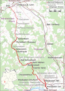
The Aar Valley Railway is a 53.7 km long line between Wiesbaden, the capital of the German state of Hesse, and Diez in Rhineland-Palatinate. From 1985 to 2007, the southern end was operated as a heritage railway with historic trains. The Hessian part of the line is heritage-listed. Currently, two bridges are unusable and several sets of points are defective and need to be repaired. Its northern end is operated with draisines.

The village of Ramchied is a district of the town of Bad Schwalbach in the Rheingau-Taunus-Kreis region of the state of Hessen, Germany. It is also referred to as Bad Schwalbach - Ramschied.

References

  1. "Ergebnisse der letzten Direktwahl aller hessischen Landkreise und Gemeinden" (XLS) (in German). Hessisches Statistisches Landesamt. 5 September 2022.
  2. "Bevölkerung in Hessen am 31.12.2020 nach Gemeinden". Hessisches Statistisches Landesamt (in German). June 2021.
  3. Bayerlein, S. 214

Further reading