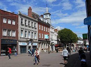
Nuneaton is a market town in the borough of Nuneaton and Bedworth in northern Warwickshire, England, located adjacent to the county border with Leicestershire to the north-east. Nuneaton's population at the 2021 census was 88,813, making it the largest town in Warwickshire.

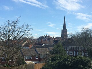
Bedworth is a market town in the borough of Nuneaton and Bedworth, Warwickshire, England. It is situated between Coventry, 6 miles to the south, and Nuneaton, 3 miles (5 km) to the north.

Atherstone is a market town and civil parish in the North Warwickshire district of Warwickshire, England. Located in the far north of the county, Atherstone is on the A5 national route, and is adjacent to the border with Leicestershire which is here formed by the River Anker. It is situated between the towns of Tamworth and Nuneaton. Atherstone is the administrative centre of the North Warwickshire district, with the offices of North Warwickshire Borough Council located in the town.

Warwickshire is a ceremonial county in the West Midlands of England. It is bordered by Staffordshire and Leicestershire to the north, Northamptonshire to the east, Oxfordshire and Gloucestershire to the south, and Worcestershire and the West Midlands county to the west. The largest settlement is Nuneaton, and the county town is Warwick.

North Warwickshire is a local government district with borough status in the ceremonial county of Warwickshire, West Midlands, England. The borough includes the two towns of Atherstone and Coleshill, and the large villages of Polesworth, Kingsbury, Hartshill and Water Orton.
Coleshill is a market town and civil parish in the North Warwickshire district of Warwickshire, England, taking its name from the River Cole, on which it stands. It had a population of 6,897 in the 2021 Census, and is situated 10 miles (16 km) east-northeast of Birmingham, 9 miles (14 km) southeast of Sutton Coldfield, 11 miles (18 km) south of Tamworth, 13 miles (21 km) northwest of Coventry by road and 13 miles (21km) west of Nuneaton.
Polesworth is a large village and civil parish in the North Warwickshire district of Warwickshire, England. It is situated close to the northern tip of Warwickshire, adjacent to the border with Staffordshire. It is 3 miles (5 km) east of Tamworth, and is 5 miles (8 km) northwest of Atherstone.

Baxterley is a small village and civil parish in the North Warwickshire district of Warwickshire in England. According to the 2001 Census, it had a population of 335, reducing to 328 at the 2011 Census. The village is about two miles west of Atherstone and is home to Jaguar Land Rover's national distribution centre.
Wood End is a former Pit village in North Warwickshire, England. It lies to the south east of Tamworth and close to the border with Staffordshire. It grew around the former Kingsbury Colliery but now it serves as a commuter village to Tamworth. It has a church, a primary school, a co-operative store, a working men's club and a village hall. The population of Wood End is 2,205, but from the 2011 Census has been included in Kingsbury.

Warwick Parkway is a railway station with park and ride facilities on the western outskirts of Warwick in Warwickshire, England. It also serves the village of Budbrooke. Unusually, the station is not owned by Network Rail but by Warwickshire County Council.

Coleshill Parkway is a railway station at Hams Hall on the Birmingham to Peterborough railway line, serving Coleshill in Warwickshire, England. Sitting on the site of the former Coleshill station which closed in 1968, the current station was opened in 2007. Unusually it is not owned by Network Rail. It is managed by West Midlands Trains train operating company (TOC) although all rail services are operated by CrossCountry.
Dordon is a village and civil parish in the North Warwickshire district of the county of Warwickshire in England and close to the border with Staffordshire. The village is located on the A5 national route and is contiguous with the larger village of Polesworth. Other nearby places include Tamworth, Atherstone, Grendon, Wood End Village, Baddesley Ensor and Nuneaton. In 2001 the population for the parish of Dordon was 3,225, reducing slightly to 3,215 at the 2011 census.

Merevale is a small village and civil parish in the North Warwickshire district of the county of Warwickshire in England. Located about one and a half miles west of Atherstone, it is the site of a medieval Cistercian Abbey and Merevale Hall.
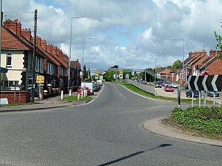
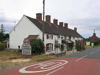
Hurley is a village in the Kingsbury civil parish of North Warwickshire, England. Other nearby places include Wood End, Hurley Common, Coleshill, Water Orton, Curdworth, Atherstone and Tamworth. According to the 2001 Census the population of the Hurley and Wood End ward was 3,642. Over 99.5% of people (3,550) described themselves as White British with only 92 people from other ethnic groups. The most common distance travelled to work is 5–10 kilometres (3.1–6.2 mi), which is essentially to Tamworth, with the most common form of employment being manufacturing. The village has an almost exact 50:50 split of males and females, with a ratio of 1,822 to 1,820 respectively.

Old Arley is a village in the civil parish of Arley, in the north of Warwickshire, England, 5.5 miles (8.9 km) west of Nuneaton and 10 miles (16 km) north west of the city of Coventry.
Piccadilly is a small village in the North Warwickshire district of the county of Warwickshire in England. It is located near to the larger village of Kingsbury, and is four miles south of Tamworth.
Hurley Common is a village in North Warwickshire, England, between Wood End and Hurley, it consists of several houses and 2 Farms, Hurley common does not have its own Parish Church so it is technically a hamlet. Population details for the 2011 Census can be found under Kingsbury.

Foul End is a small hamlet in the civil parish of Kingsbury, in the North Warwickshire district, in the county of Warwickshire, England. Other nearby places include Hurley, Wood End, Hurley Common, Coleshill, Water Orton, Curdworth, Atherstone and Tamworth.
Coventry Colliery was a coal mine located in the village of Keresley End in northern Warwickshire, between Bedworth and Coventry, England. Closed in 1991, the site today has been redeveloped as a distribution park, owned by Prologis.

Grendon is a civil parish which includes both Old Grendon and New Grendon in North Warwickshire, England. Old Grendon is a village situated three miles (5 km) west of Atherstone and five miles (8 km) east of Tamworth centred on the A5. It lies on the north-western tip of Warwickshire, divided from Leicestershire by a small stream and by the River Anker. Also, Grendon has since enlarged and has a population of 1000.

