
Cavendish is a village and parish in the Stour Valley in Suffolk, England.
Tingewick is a village and civil parish about 2.5 miles (4.0 km) west of Buckingham in the Aylesbury Vale district of Buckinghamshire, England. The parish is bounded to the north by the River Great Ouse, to the east by a tributary of the Great Ouse, to the west by the county boundary with Oxfordshire and to the south by field boundaries.
Twyford is a village and civil parish in the Aylesbury Vale district of Buckinghamshire, England. It is about 2 miles (3 km) west of Steeple Claydon and 4 miles (6.4 km) northeast of Bicester in Oxfordshire.

Reydon is a village and civil parish, 1.0 mile (1.6 km) north-west of Southwold and 2.5 miles (4.0 km) south-east of Wangford, in the East Suffolk district and the ceremonial county of Suffolk in England. It had a population of 2,567 in 2001, including Easton Bavents. This rose minimally to 2,582 at the 2011 Census. The name probably means Rye Hill, Rey meaning rye and -don being an old word for hill or rise). The village is close to the cliffs at Easton Bavents, a village now much eroded. Both were established before neighbouring Southwold. The parish church is St Margaret of Antioch. The parish of Easton Bavents was merged with Reydon in 1987. Part of Southwold was also transferred to Reydon.

Barby is a village and civil parish about 5 miles (8 km) north of Daventry in Northamptonshire, England. The 2011 Census recorded the parish population as 2,336. Barby is located right off the M45 motorway a short spur from the M1 motorway to the A45 Trunk Road.

Ash is a village and civil parish in the Dover district of east Kent about three miles west of Sandwich.

Cold Ash is a village and civil parish in West Berkshire centred 1 mile (1.6 km) from Thatcham and 2.5 miles (4 km) northeast of Newbury, England.

Wrentham is a village and civil parish in the East Suffolk district, in the north-east of the English county of Suffolk. It is located about 2 miles (3.2 km) from the North Sea coast on the A12 trunk road, about 7 miles (11 km) south-west of Lowestoft, 4 miles (6.4 km) north of Southwold and 6 miles (9.7 km) south-east of Beccles.

Wangford is a village and former civil parish, now in the parish of Wangford with Henham, in the East Suffolk district, in the county of Suffolk, England, just off the A12 trunk road on the edge of the Henham Park estate just outside Southwold.
Bardwell is a village and civil parish in the West Suffolk district of Suffolk, England.
Barking is a village and civil parish in the Mid Suffolk district of the English county of Suffolk. It is 2 miles (3 km) west of Needham Market on the B1078 road. The village is linear along the road with its centre being around the area known as Barking Tye and away from the large village church of St Mary. There are six bells that hang the church of St Mary with the largest weighing 11 cwt - 1 qr - 7 lb. All 6 bells were recast and rehung in 1911 by Alfred Bowell.

Hunston is a small Suffolk village and civil parish set in a conservation area of Mid-Suffolk and lies between Stowlangtoft and Badwell Ash off the A1088, nearly eight miles east of the centre of Bury St Edmunds. It is set in flattish farmland, mostly arable.
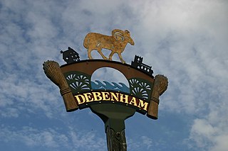
Debenham is a village and civil parish in the Mid Suffolk district of Suffolk, England. The River Deben rises in the parish, and flows along a prolonged ford through the village.
Stadhampton is a village and civil parish about 5 miles (8 km) north of Wallingford, in South Oxfordshire, England. Stadhampton village is on the A329 road and close to the River Thame.

Wootton is a village and civil parish on the River Glyme about 2 miles (3 km) north of Woodstock, Oxfordshire. In recent years the village is sometimes referred to as Wootton-by-Woodstock to distinguish it from Wootton, Vale of White Horse, which was in Berkshire but was transferred to Oxfordshire in the 1974 local authority boundary changes. The 2011 Census recorded the parish's population as 469.

Semer is a small village and civil parish in Suffolk, England. Located adjacent to a bridge over the River Brett on the B1115 between Hadleigh and Stowmarket, it is part of Babergh district. The parish also contains the hamlets of Ash Street and Drakestone Green.
Tredington is a village and civil parish on the River Stour in Warwickshire, England. The village is 2 miles (3 km) north of Shipston-on-Stour. The civil parish includes the village of Newbold on Stour and hamlets of Armscote, Blackwell and Darlingscott. The 2011 Census recorded the parish population as 1,422.

Stonham Aspal is a village and civil parish in the Mid Suffolk district of Suffolk in eastern England, some five miles east of the town of Stowmarket. Nearby villages include Mickfield, Little Stonham and Pettaugh. Its population in 2011 was 601. The village has a primary school. It is set in farmland, but has a busy main road, A1120, running through.
Stoke Ash is a village and civil parish in the Mid Suffolk district of Suffolk in eastern England. Located around six miles south of Diss, in 2011 its population was 314. The village shares a parish council with neighbouring Thwaite. It is located on the A140 road from Norwich to Ipswich The name 'Stoke', comes from 'stoc', which means a place or a secondary settlement in old English. The word 'Ash', comes from the Anglian word 'æsc', which means ash-tree. The name Ash was added to the name Stoke in the sixteenth century. In 1086 Stoke Ash was known as Stoches Stotas.

Ufford is a village and civil parish in Suffolk, England. For the 2001 census, it had a population of 808, which increased to 948 at the 2011 Census. The village lies 2 miles south-south-west of Wickham Market and 13 miles north-east of Ipswich. The main road through the village has been renumbered B1438 since it was replaced as a trunk road by the new A12.


