Barisal District

Last updated

Barisal District
বরিশাল জেলা
Barishal District
Barisal Cityscape, 2015.jpg
Guthiya mosque Ri palash 03.jpg
durgaasaagr.JPG
Oxford Mission Church, Barishal.JPG
BM College, Barisal.jpg
Bell's Park aka Bangabandhu Udyan Barisal.jpg
ksbaa msjid 30.jpg
kaauy'aar cr pherighaatt .jpg
bijy' gupter mnsaa mndir 13.jpg
ulaaniy'aa jmidaar baadd'i jaame msjid.jpg
From top: City skyline, Guthia Mosque, Durga Sagar lake, Oxford Mission Church, Brojomohun College, Bell's Park aka Bangabandhu Udyan, Kasba Mosque, Paddle steamer at Kirtonkhola River port, Satlar Bil, Manasa Mandir of Bijoy Gupta and Ulania Zamnindar Bari Mosque.
BD Barishal District locator map.svg
Location of Barisal District in Bangladesh
Barisal District
Expandable map of Barisal District
Coordinates: 22°48′N90°22′E / 22.80°N 90.37°E / 22.80; 90.37
CountryFlag of Bangladesh.svg  Bangladesh
Division Barisal
Bakerganj District 1797
Seat Barisal
Government
   Deputy Commissioner S.M. Ajior Rahman
   District Council Chairman Md. Moidul Islam [1]
  Chief Executive OfficerMd. Monik-har Rahman
Area
  Total2,784.52 km2 (1,075.11 sq mi)
Population
 (2022) [2]
  Total2,570,446
  Density920/km2 (2,400/sq mi)
Demonyms Borishailla
Time zone UTC+06:00 (BST)
Postal code
8200
HDI (2018)0.672 [3]
medium · 2nd of 21

Barisal District, officially spelled Barishal District from April 2018, [4] is a district in south-central Bangladesh, formerly called Bakerganj district, established in 1797. [5] Its headquarters are in the city of Barisal, which is also the headquarters of Barisal Division. [6]

Contents

History

Barisal District traces its origins to Bakerganj district which was established in 1797. It was placed in Barisal Division on 1 January 1993. [5]

Education

Notable educational institutions in Barisal include

Demographics

Historical population
YearPop.±% p.a.
1974 1,648,068    
1981 1,965,950+2.55%
1991 2,207,426+1.17%
2001 2,355,967+0.65%
2011 2,324,310−0.14%
2022 2,570,446+0.92%
Sources: [2] [7]

At the 2022 Census, Barisal District had 629,626 households and a population of 2,570,446. 475,192 (18.49%) were under 10 years of age. The population density was 923 people per km2. Barisal district had a literacy rate (age 7 and over) of 79.85%, compared to the national average of 74.80%, and a sex ratio of 1047 females per 1000 males. 30.23% of the population lived in urban areas. [2]

Religion

Religions in Barisal district (2022) [2]
ReligionPercent
Islam
88.84%
Hinduism
10.71%
Christianity
0.43%
Other or not stated
0.02%
Religion in present-day Barisal district [lower-alpha 1]
ReligionPopulation (1941) [8] :100–101Percentage (1941)Population (2022) [2] Percentage (2022)
Islam Star and Crescent.svg 724,28966.17%2,283,65888.84%
Hinduism Om.svg 361,60233.04%275,25810.71%
Christianity Christian cross.svg 8,5360.78%11,1380.43%
Others [lower-alpha 2] 1730.02%3920.02%
Total Population1,094,600100%2,570,446100%

Islam is the predominant religion in the district with a large Hindu population. Historically, the Barisal region has seen one of the highest concentration of Hindus since the area had been part of the British Raj, through the rule of East Pakistan and subsequently after the independence of Bangladesh. However, since Partition Hindus have been fleeing the district in large numbers. Among the 10 upazilas of the district, the Agailjhara Upazila has the highest percentage share of Hindus at 42 per cent, while the Muladi Upazila has the lowest at just 1.8 per cent, according to the 2011 Bangladesh census.

Overall, minority populations have seen a steep drop in their share of the total population, as well as a fall in their absolute numbers in Barisal district. The trend is similar to other districts in the wider Barisal division.

Subdivisions

Barisal District is divided into the following Upazilas (formerly called Thanas):

  1. Agailjhara Upazila
  2. Babuganj Upazila
  3. Bakerganj Upazila
  4. Banaripara Upazila
  5. Barisal Sadar Upazila
  6. Gournadi Upazila
  7. Hizla Upazila
  8. Mehendiganj Upazila
  9. Muladi Upazila
  10. Wazirpur Upazila

Notable personalities

Notes

  1. Sadar subdivision of Bakerganj district without Nalchiti, Jhalokati and Rajapur thanas
  2. Including Jainism, Buddhism, Zoroastrianism, Judaism, Ad-Dharmis, or not stated

Related Research Articles

<span class="mw-page-title-main">Barisal Division</span> Division of Bangladesh

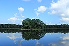
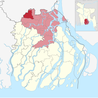
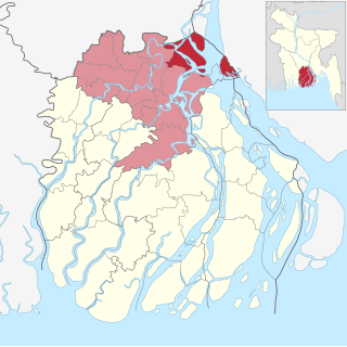
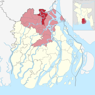
Barisal Division is one of the eight administrative divisions of Bangladesh. Located in the south-central part of the country, it has an area of 13,644.85 km2 (5,268.31 sq mi), and a population of 9,100,102 at the 2011 Census. It is the least populous Division in Bangladesh. It is bounded by Dhaka Division on the north, the Bay of Bengal on the south, Chittagong Division on the east and Khulna Division on the west. The administrative capital, Barisal city, lies in the Padma River delta on an offshoot of the Arial Khan River. Barisal division is criss-crossed by numerous rivers that earned it the nickname Dhan-Nodi-Khal, Ei tin-e Borishal.

<span class="mw-page-title-main">A. K. Fazlul Huq</span> Bengali statesman and jurist (1873–1962)

Abul Kasem Fazlul Huq, popularly known as Sher-e-Bangla, was a Bengali lawyer and politician who presented the Lahore Resolution which had the objective of creating an independent Pakistan. He also served as the first and longest Prime Minister of Bengal during the British Raj.

<span class="mw-page-title-main">Faridpur District</span> District in Dhaka, Bangladesh

Faridpur District is a district in south-central Bangladesh. It is a part of the Dhaka Division. It is bounded by the Padma River to the northeast. The district was named for its headquarters Faridpur town, which itself was named for Farīd-ud-Dīn Masʿūd, a 13th-century Sufi saint. A separate district was created by severing Dhaka district in 1786 and was called Dacca Jelalpur. A municipality was established in 1869. Historically, the town was known as Fatehabad. It was also called Haveli Mahal Fatehabad.

<span class="mw-page-title-main">Barguna District</span> District of Bangladesh in Barisal Division

Barguna is a district in the division of Barisal, in southern Bangladesh. Barguna subdivision was established in 1969 and promoted to a district on 28 February 1984.

<span class="mw-page-title-main">Patuakhali District</span> District in Barisal Division, Bangladesh

Patuakhali is a district in south-central Bangladesh in the Barisal Division. This district is the main entrance for the beach of Kuakata.

<span class="mw-page-title-main">Sirajganj District</span> District of Bangladesh in Rajshahi Division

Sirajganj District is a district in the North Bengal region of Bangladesh, located in the Rajshahi Division. It is an economically important district of Bangladesh. Sirajganj district is the 25th largest district by area and 9th largest district by population in Bangladesh. It is known as the gateway to North Bengal.

<span class="mw-page-title-main">Barisal</span> City in Barisal Division, Bangladesh

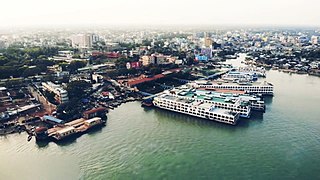
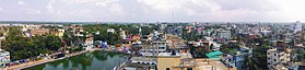
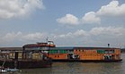
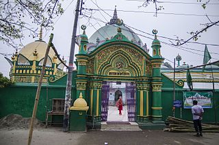
Barisal, officially known as Barishal, is a major city that lies on the banks of the Kirtankhola river in south-central Bangladesh. It is the largest city and the administrative headquarter of both Barisal District and Barisal Division. It is one of the oldest municipalities and river ports of the country. The city was once called the Venice of the East or the Venice of Bengal.

<span class="mw-page-title-main">Brojomohun College</span>

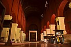
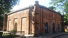
Govt. Brojomohun College, Barishal is one of the oldest institutions of higher education in Bangladesh. It is located in the city of Barishal in south-western Bangladesh.

<span class="mw-page-title-main">Agailjhara Upazila</span> Upazila in Barisal Division, Bangladesh

Agailjhara is an upazila (sub-district) of southern Bangladesh's Barisal District, part of the Barisal Division.

<span class="mw-page-title-main">Banaripara Upazila</span> Upazila in Barisal, Bangladesh

Banaripara is an Upazila of Barishal District in the Division of Barishal in southern-central Bangladesh.

<span class="mw-page-title-main">Hizla Upazila</span> Upazila in Barisal, Bangladesh

Hizla is the largest upazila (sub-district) of southern Bangladesh's Barisal District.

<span class="mw-page-title-main">Mehendiganj Upazila</span> Upazila in Barisal, Bangladesh

Mehendigonj is an Upazila of Barisal District in the Division of Barisal, Bangladesh. Mehendigonj is popularly known as Patarhat by the local people.

<span class="mw-page-title-main">Muladi Upazila</span> Upazila in Barishal Division, Bangladesh

Muladi is an Upazila of Barishal District in the Division of Barishal, Bangladesh.

<span class="mw-page-title-main">Jhalokati Sadar Upazila</span> Upazila in Barisal, Bangladesh

Jhalakathi Sadar is an upazila of Jhalokati District in the Division of Barisal, Bangladesh.

<span class="mw-page-title-main">Nalchity Upazila</span> Upazila in Barisal Division, Bangladesh

Nalchity is an upazila of Jhalokati District in the division of Barisal, Bangladesh.

<span class="mw-page-title-main">Rajapur Upazila</span> Upazila in Barisal Division, Bangladesh

Rajapur is an upazila (sub-district) of southern Bangladesh's Jhalokati District, part of the Barisal Division.

<span class="mw-page-title-main">Bhaluka Upazila</span> Upazila in Mymensingh Division, Bangladesh

Bhaluka is an upazila of the Mymensingh District located in Bangladesh. It is one of the oldest small business hubs in the area.

<span class="mw-page-title-main">Barishal Zilla School</span> Public school in Bangladesh

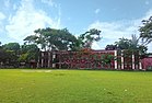
Barishal Zilla School, popularly known as BZS, is a public educational institution for boys, located in Barisal, Bangladesh. It was the first high school established in Barisal Division. Founded as Barisal English School on 23 December 1829 by W. N. Garrett, it began with 27 students. In 1853, the school was renamed Barisal Zilla School.

<span class="mw-page-title-main">Khan Bahadur Hasem Ali Khan</span> Bengali politician, lawyer, peasant movement leader and social worker (1888-1962)

Khan Bahadur Hasem Ali Khan was a Bengali politician, lawyer, peasant movement leader and social worker. He was a close associate of A. K. Fazlul Huq. He became a Minister in the Bengal Legislature in 1941 in the second cabinet led by Huq. During his political life, he tried to establish rights of farmers and common people. He was conferred the title of Khan Bahadur by the British Raj as recognition of his contribution for maintaining peaceful relations between people of different faiths.

Govt. Fazlul Huq College is a public institution for higher education in Chakhar, a small town in Barisal district in Bangladesh. It was founded in 1940 by then Prime Minister of Bengal A K Fazlul Huq with a view to creating opportunity of higher education to underprivileged students in rural areas. It offers Higher Secondary School Certificate (HSC), as well as 3 years degree(pass) courses and 4 years honours programs which divisions are affiliated to the National University, Bangladesh. It is the second oldest and largest college in Barisal division and was previously affiliated with University of Calcutta before partition and University of Dhaka after formation of Pakistan and Bangladesh respectively.

References

  1. barisal.gov.bd
  2. 1 2 3 4 5 Population and Housing Census 2022 National Report (PDF). Vol. 1. Bangladesh Bureau of Statistics. November 2023.
  3. "Sub-national HDI - Area Database - Global Data Lab". hdi.globaldatalab.org. Retrieved 18 March 2020.
  4. Mahadi Al Hasnat (2 April 2018). "Mixed reactions as govt changes English spellings of 5 district names". Dhaka Tribune. Retrieved 8 April 2018.
  5. 1 2 KAM Saiful Islam (2012). "Barisal District". In Sirajul Islam and Ahmed A Jamal (ed.). Banglapedia: National Encyclopedia of Bangladesh (Second ed.). Asiatic Society of Bangladesh.
  6. About Barisal Archived 20 January 2017 at the Wayback Machine Local Government Engineering Department, Local Government Division, Ministry of Local Government, Rural Development & Cooperatives; retrieved 14 May 2014.
  7. "Bangladesh Population and Housing Census 2011 Zila Report – Barisal" (PDF). bbs.gov.bd. Bangladesh Bureau of Statistics.
  8. "Census of India, 1941 Volume VI Bengal Province" (PDF). Retrieved 13 August 2022.