Barnoldby le Beck

Last updated

Barnoldby le Beck
St. Helen's Church, Barnoldby-le-Beck - geograph.org.uk - 386522.jpg
Church of St Helen's
Lincolnshire UK location map.svg
Red pog.svg
Barnoldby le Beck
Location within Lincolnshire
Population346 (2011) [1]
OS grid reference TA236032
  London 140 mi (230 km)  S
Civil parish
  • Barnoldby le Beck
Unitary authority
Ceremonial county
Region
Country England
Sovereign state United Kingdom
Post town GRIMSBY
Postcode district DN37
Dialling code 01472
Police Humberside
Fire Humberside
Ambulance East Midlands
UK Parliament
List of places
UK
England
Lincolnshire
53°30′47″N0°07′12″W / 53.513128°N 0.12°W / 53.513128; -0.12

Barnoldby le Beck is a village and civil parish in North East Lincolnshire, England, It is situated just east of the A18 and is close to the village of Waltham and the town of Grimsby.

Contents

Etymology

The name Barnoldby le Beck has origins in the Norse settlement of North East Lincolnshire. The affix by means a farm or settlement and is preceded by the modern phrasing of the personal name Bjǫrnulfr. While le beck reflects the Scandinavian word bekkr which means stream. [2]

History

In the Domesday Book of 1086, Barnoldby le Beck was a large village with 9 smallholders, 26 freeman, 12 ploughlands and a meadow of 200 acres. In 1066, the lord was Ralph the Staller, a constable of Edward the Confessor, and in 1086, the lord and tenant in chief was Alan Rufus. [3]

Early land holders in the Middle Ages included the Abbot of Grimsby, John Yarborough and Geoffrey le Scrope. [4]

Following the Enclosure of common lands in 1769 there were 12 landholders, including the Dashwood, Hewson and Bonsor families. [4]

In 1820, the population of the village was 230, [4] 232 in 1831, [5] and in 1851 it was 269. [6]

In 1855, the lord of the manor was B. Auningson and Miss Eleanor Tupling was the landlady of the Ship inn. [6]

Church of St Helen's

The earliest surviving parts of the church date to the 13th century with later additions over the next 200 years. Renovations took place in 1839 and, by Ewan Christian, in 1892. In 1901–2, the porch and tower were rebuilt. A font bowl in the south aisle, dates to the 11th or 12th century. [7]

Following the English Civil War, Anthony Harewood, the Royalist rector of the church of St. Helen's was replaced by a Puritan minister at the direction of the Earl of Manchester. [4] The appointment of the new minister divided the village's inhabitants and some became early Quakers following a visit by a missionary for George Fox. [4]

In 1855, the living of the rectory was in the gift of the Chapter of Southwell Collegiate church and worth £200. The incumbent at that time was Rev. H. M. Beecher. The village also had Primitive Methodist and Wesleyan chapels. [6]

Community

The population of the parish in the 2011 Census was 346 residents. [8]

The village public house is the Ship Inn, situated on Main Road.

Barnoldby Orange Miss

Osmond & Sons, farmers based in Barnoldby le Beck, were well known for their prize-winning herd of Herefords

Barnoldby Orange Miss, named for the village and bred here, was voted supreme champion Hereford Heifer at the Royal Smithfield Show in Earls Court, London and was presented to the Queen along with Ray Osmond on 7 December 1965. [9]

Notable people

Related Research Articles

<span class="mw-page-title-main">North Thoresby</span> Village and civil parish in the East Lindsey district of Lincolnshire, England

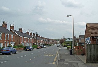
North Thoresby is a village and civil parish in the East Lindsey district of Lincolnshire, England. It is situated between Louth and Grimsby, approximately 7.5 miles (12 km) from each. and has a village population of 1,068 (2011) Some 50.5% of the population is older than 60 years.

<span class="mw-page-title-main">Swallow, Lincolnshire</span> Small village and civil parish in the West Lindsey district of Lincolnshire, England

Swallow is a small village and civil parish in the West Lindsey district of Lincolnshire, England, on the A46 road 4 miles (6.4 km) north-east from Caistor. The population taken at the 2011 census was 289.

<span class="mw-page-title-main">Immingham</span> Town and civil parish in Lincolnshire, England

Immingham is a town and civil parish in North East Lincolnshire, in Lincolnshire, England. It is situated on the south-west bank of the Humber Estuary, and is six miles northwest of Grimsby.

<span class="mw-page-title-main">Stickney, Lincolnshire</span> Linear village and civil parish in the East Lindsey district of Lincolnshire, England

Stickney is a linear village and civil parish in the East Lindsey district of Lincolnshire, England. It was an ancient parish in Lincoln County. Its population has increased since late 20th-century immigration and is 1127 as of 2011.

<span class="mw-page-title-main">Healing, Lincolnshire</span> Human settlement in England

Healing is a village and civil parish in North East Lincolnshire, England. It is situated between Stallingborough and Great Coates, and 3 miles (5 km) west from Grimsby.

<span class="mw-page-title-main">Althorpe</span> Small village in North Lincolnshire, England

Althorpe is a small village and former civil parish, now in the parish of Keadby with Althorpe, in the North Lincolnshire district, in the ceremonial county of Lincolnshire, England. It is four miles (6 km) west of Scunthorpe and the same distance south-east of Crowle, on the A18 road.

<span class="mw-page-title-main">Aylesby</span> Village and civil parish in North East Lincolnshire, England

Aylesby is a village and civil parish in North East Lincolnshire, England. It is situated near the A18 road, approximately 4 miles (6 km) west from Cleethorpes and north of Laceby. The population at the 2001 census was 135, increasing to 155 at the 2011 Census.

<span class="mw-page-title-main">Bradley, Lincolnshire</span> Village and civil parish in North East Lincolnshire, England

Bradley is a village and civil parish in North East Lincolnshire, England. It is situated approximately 3 miles (5 km) south-west from Grimsby and 2 miles (3 km) north from Barnoldby le Beck. Its population recorded in the census for both 2001 and 2011 was 198.

<span class="mw-page-title-main">Hatcliffe</span> Small village and civil parish in rural North East Lincolnshire, England

Hatcliffe is a small village and civil parish in rural North East Lincolnshire, England. It is situated 6 miles (10 km) south-west from Grimsby and 1.5 miles (2.4 km) west from the A18. Less than 1 mile (1.6 km) to the north is the neighbouring village of Beelsby.

<span class="mw-page-title-main">Irby upon Humber</span> Small village and civil parish in North East Lincolnshire, England

Irby upon Humber or Irby-on-Humber is a small village and a civil parish in North East Lincolnshire, England. The village is situated on the A46 road, 1.5 miles (2.4 km) south-west of Laceby.

<span class="mw-page-title-main">Laceby</span> Village and civil parish in North East Lincolnshire, England

Laceby is a village and civil parish in North East Lincolnshire, England. It is situated on the A46 road, just outside the western boundary of Grimsby. Laceby's population at the 2001 Census was 2,886, increasing to 3,259 at the 2011 Census. The village is noted for its parish church, parts of which date to the 12th century.

<span class="mw-page-title-main">Stallingborough</span> Human settlement in England

Stallingborough is a village and civil parish in North East Lincolnshire, England. The population of the civil parish at the 2011 census was 1,234.

<span class="mw-page-title-main">Barnetby le Wold</span> Small rural village and civil parish in North Lincolnshire, England

Barnetby le Wold is a village and civil parish in North Lincolnshire, Lincolnshire, England, located between Brigg and Immingham. The village is also near Barton-upon-Humber. The population of the parish in the 2001 census was 1,593. This increased by 148 to 1,741 in the 2011 census.

<span class="mw-page-title-main">Bilsby</span> Village in East Lindsey district, Lincolnshire, England

Bilsby is a village and civil parish in the East Lindsey district of Lincolnshire, England. It lies on the main A1111 road between Alford and Sutton-on-Sea, 1 mile (1.6 km) east of Alford. Thurlby and Asserby are hamlets within Bilsby parish. The censuses showed a parish population of 538 in 2001 and 487 in 2011, with an estimate of 489 in 2019.

<span class="mw-page-title-main">Glentham</span> Village and civil parish in the West Lindsey district of Lincolnshire, England

Glentham is a village and civil parish in the West Lindsey district of Lincolnshire, England. It is situated on the A631, 6 miles (9.7 km) west from Market Rasen, and 2 miles (3.2 km) east from Caenby Corner and the A15. The village includes the hamlet of Caenby.

<span class="mw-page-title-main">Lancet window</span> Tall, narrow window with a pointed arch at its top

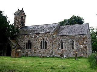
A lancet window is a tall, narrow window with a pointed arch at its top. It acquired the "lancet" name from its resemblance to a lance. Instances of this architectural element are typical of Gothic church edifices of the earliest period. Lancet windows may occur singly, or paired under a single moulding, or grouped in an odd number with the tallest window at the centre.

<span class="mw-page-title-main">Mareham le Fen</span> Village in Lincolnshire, England

Mareham le Fen is a village and civil parish about 6 miles (10 km) south from the town of Horncastle, Lincolnshire, England. The hamlet of Mareham Gate lies about 0.5 miles (0.8 km) south from the village, and it is believed that the deserted medieval village (DMV) of Birkwood is situated nearby.

<span class="mw-page-title-main">Holton-le-Clay</span> Village and civil parish in Lincolnshire, England

Holton-le-Clay is a village and civil parish in the East Lindsey district of Lincolnshire, England, around 5 miles (8.0 km) south of Grimsby.

<span class="mw-page-title-main">Fulstow</span> Marsh village and civil parish in the East Lindsey district of Lincolnshire, England

Fulstow is a marsh village and civil parish in the East Lindsey district of Lincolnshire, England. It is situated 6 miles (10 km) north of Louth and 8 miles (13 km) south of Grimsby.

<span class="mw-page-title-main">Waithe</span> Hamlet and civil parish in the East Lindsey district of Lincolnshire, England

Waithe is a hamlet and civil parish in the East Lindsey district of Lincolnshire, England. It is on the A16, 1 mile (1.6 km) south from Holton-le-Clay and 1 mile (1.6 km) north from North Thoresby.

References

  1. "Parish population 2011". Neighbourhood Statistics. Office for National Statistics. Retrieved 17 August 2015.
  2. Mills, A. D. (2011). "Barnoldby le Beck". A Dictionary Of British Place Names . Oxford Reference. Retrieved 9 August 2014.
  3. "Place: Barnoldby le Beck". Open Domesday. Archived from the original on 9 August 2014. Retrieved 9 August 2014.
  4. 1 2 3 4 5 The Gentleman's Magazine, and Historical Chronicle. E. Cave. 1833. p. 505.
  5. Great Britain. Poor Law Commissioners (1837). Annual Report of the Poor Law Commissioners for England and Wales. Poor Law Commission Office. p. 253.
  6. 1 2 3 Post Office Directory of Lincolnshire, 1855. 1855. p. 239.
  7. Historic England. "Church of St. Helens (81620)". Research records (formerly PastScape). Retrieved 9 August 2014.
  8. "Area: Barnoldby le Beck (Parish). Residence Type, 2011 (QS101EW)". 2001 United Kingdom census. Office for National Statistics. 30 January 2013. Retrieved 9 August 2014.
  9. "Queen Elizabeth II inspects the Supreme Champion, Hereford heifer Barnoldby Orange Miss..." www.alamy.com. 7 December 1965. Retrieved 12 September 2023.