
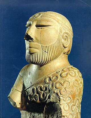
Sindhis are an Indo-Aryan ethnolinguistic group who speak the Sindhi language and are native to the Sindh province of Pakistan. The historical homeland of Sindhis is bordered by the southeastern part of Balochistan, the Bahawalpur region of Punjab and the Kutch region of Gujarat, India. Having been isolated throughout history unlike its neighbours, Sindhi culture has preserved its own uniqueness.

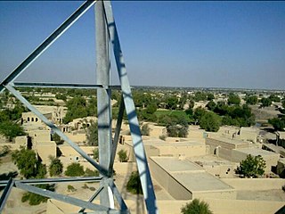
Khairpur is a city and the capital of the Khairpur District of Pakistan's Sindh province.

Thatta is a city in the Pakistani province of Sindh. Thatta was the medieval capital of Sindh, and served as the seat of power for three successive dynasties. Thatta's historic significance has yielded several monuments in and around the city. Thatta's Makli Necropolis, a UNESCO World Heritage Site, is site of one of the world's largest cemeteries and has numerous monumental tombs built between the 14th and 18th centuries designed in a syncretic funerary style characteristic of lower Sindh. The city's 17th century Shah Jahan Mosque is richly embellished with decorative tiles, and is considered to have the most elaborate display of tile work in the South Asia.

The Battle of Miani was a battle between forces of the Bombay Army of the East India Company, under the command of Charles Napier and the Baluch army of Talpur Amirs of Sindh, led by Mir Nasir Khan Talpur. The battle took place on 17 February 1843 at Miani, Sindh, in what is now modern-day Pakistan. This battle and the subsequent Battle of Hyderabad eventually led to the capture of parts of Sindh region, first territorial possession by the East India Company in what is the modern-day state of Pakistan.

Ranikot Fort is a historical Talpur fort near Sann, Jamshoro District, Sindh. in Pakistan. Ranikot Fort is also known as The Great Wall of Sindh and is believed to be the world's largest fort, with a circumference of approximately 32 kilometres (20 mi). The fort's ramparts have been compared to the Great Wall of China.

The State of Khairpur, also transliterated as Khayrpur, was a princely state of British India on the Indus River in northern Sindh, modern Pakistan, with its capital city at Khairpur. It was established as capital for the Sohrabani branch of the Talpur dynasty, and was established shortly after Talpur ascendency in 1783 as one of several Talpur dominions. Whereas the other Talpur dominions were conquered by the British in 1843, the Khairpur state entered into treaty with the British, thereby maintaining some of its autonomy as a princely state. The last Mir of Khairpur opted to join the new state of Pakistan in 1947, and the dominion was thus made a Princely state of Pakistan, until it was fully amalgamated into West Pakistan in 1955.
His Highness Mir Tharo Khan, Sitara-i-Jang, was the founder of the Mankani Talpur state in southeastern Sindh. Talpurs defeated Kalhora rulers and founded their rule over Sindh. Mir Tharo Khan Talpur participated in the Battle of Halani against Kalhoras. However, when Mir Fateh Ali Talpur started rule from Hyderabad (Sindh), HH Mir Tharo Khan Talpur went to southeastern Sindh and founded a state under his own crown, which was called the state of Mir Pur Khas in 1784, located at Keti Mir Tharo.
The history of Sindh refers to the history of the modern-day Pakistani province of Sindh, as well as neighboring regions that periodically came under its sway.
Bhurgri is a Baloch tribe which lives in various provinces of Pakistan.

The area of Karachi in Sindh, Pakistan has a natural harbor and has been used as fishing port by local fisherman belonging to Sindhi tribes since prehistory. Archaeological excavations have uncovered a period going back to Indus valley civilisation which shows the importance of the port since the Bronze Age. The port city of Banbhore was established before the Christian era which served as an important trade hub in the region, the port was recorded by various names by the Greeks such as Krokola, Morontobara port, and Barbarikon, a sea port of the Indo-Greek Bactrian kingdom and Ramya according to some Greek texts. The Arabs knew it as the port of Debal, from where Muhammad bin Qasim led his conquering force into Sindh in AD 712. Lahari Bandar or Lari Bandar succeeded Debal as a major port of the Indus; it was located close to Banbhore, in modern Karachi. The first modern port city near Manora Island was established during British colonial Raj in the late 19th century.

The Talpur dynasty were rulers based in Sindh. Four branches of the dynasty were established following the defeat of the Kalhora dynasty at the Battle of Halani in 1783: one ruled lower Sindh from the city of Hyderabad, another ruled over upper Sindh from the city of Khairpur, a third ruled around the eastern city of Mirpur Khas, and a fourth was based in Tando Muhammad Khan. The Talpurs were ethnically Baloch. For most of their rule, they were subordinate to the Durrani Empire and were forced to pay tribute to them.

Khudabad is a city in Dadu District, Sindh, Pakistan. It served as capital of the Kalhora dynasty between 1719 and 1768, when the capital was shifted to Hyderabad.
Mehrabpur, (Sindhi:محرابپور), is a city in the Naushahro Feroze District in the Sindh province of Pakistan. The city is administratively subdivided into 8 Union Councils. It has a busy railway station on the main railway line between Karachi and Lahore. It is a junction station with a disused branch line to Naushahro Feroze.
Tando Qaiser is a town in Hyderabad District, Pakistan. It is named after the 18th-century leader of the Nizamani tribe in Sindh, Qaiser Khan Nizamani, who founded the village after his son Gulham Ali Nizamani died there whilst Qaiser, his younger brother, Aloda and their forces were moving north to their original home of Dera Ghazi Khan in Southern Punjab. Tando means 'fortified settlement' and indicates the original settlement founded by Qaiser was a militarily fortified settlement.
The Balochs of Sindh, also known as the Sindhi Balochs, is a community of Sindhi-speaking Baloch tribes living in the Northern part of Sindh province.

Mian Sarfaraz Kalhoro, known as Khudayar Khan, was the famous king of the Kalhora Dynasty that ruled Sindh from 1701 to 1783. He reigned from 1772 to 1775. He ascended the throne of Sindh after the death of his father Mian Ghulam Shah Kalhoro He was given the title of Khudayar Khan by the Mughal Emperor Shah Alam II and is known to have assisted Timur Shah Durrani prior to the Third Battle of Panipat.

The Kalhora dynasty was a Muslim dynasty based in the region of Sindh, present day's Pakistan. The dynasty ruled Sindh and parts of the Punjab region between 1701 and 1783 from their capital of Khudabad, before shifting to Hyderabad from 1768 onwards. They were assigned to hold authority by the Mughal Grand Vizier Mirza Ghazi Beg and later formed their own independent dynasty, and they were known as the "Kalhora Nawabs" by the Mughal emperors.

Naukot Fort is a fortification that was established by Mir Karam Ali Khan Talpur in 1814. It is situated in Mithi Taluqa, Tharparkar District, approximately 64 km in the south of Mirpur Khas town, Sindh. Its location gave it its other common name, "The Gateway to the Thar Desert". It is meant to guard the area against the Rajputs.
Drigh Bala is a historical town in Johi Taluka of Dadu District, Sindh, Pakistan, located in Kachho desert near the Nai Gaj, established by Talpur Amirs during early Kalhora period. The graveyard of Mir Allahyar Talpur-I is situated close to this town. This necropolis of Kalhora Dynasty and Talpur Dynasty is a historical heritage of Sindh near this town. The education facility is available in the town at secondary level. The Rural Health Center is working as well.