Baudette River

Last updated

The Baudette River is a short tributary of the Rainy River in northern Minnesota in the United States. Via the Rainy River, Lake of the Woods, the Winnipeg River, Lake Winnipeg and the Nelson River, it is part of the Hudson Bay watershed. It drains a flat region which was a prehistoric lake bed of glacial Lake Agassiz.

Tributary stream or river that flows into a main stem river or lake

A tributary or affluent is a stream or river that flows into a larger stream or main stem river or a lake. A tributary does not flow directly into a sea or ocean. Tributaries and the main stem river drain the surrounding drainage basin of its surface water and groundwater, leading the water out into an ocean.

Minnesota State of the United States of America

Minnesota is a state in the Upper Midwest and northern regions of the United States. Minnesota was admitted as the 32nd U.S. state on May 11, 1858, created from the eastern half of the Minnesota Territory. The state has a large number of lakes, and is known by the slogan the "Land of 10,000 Lakes". Its official motto is L'Étoile du Nord.

United States federal republic in North America

The United States of America (USA), commonly known as the United States or America, is a country composed of 50 states, a federal district, five major self-governing territories, and various possessions. At 3.8 million square miles, the United States is the world's third or fourth largest country by total area and is slightly smaller than the entire continent of Europe's 3.9 million square miles. With a population of over 327 million people, the U.S. is the third most populous country. The capital is Washington, D.C., and the largest city by population is New York City. Forty-eight states and the capital's federal district are contiguous in North America between Canada and Mexico. The State of Alaska is in the northwest corner of North America, bordered by Canada to the east and across the Bering Strait from Russia to the west. The State of Hawaii is an archipelago in the mid-Pacific Ocean. The U.S. territories are scattered about the Pacific Ocean and the Caribbean Sea, stretching across nine official time zones. The extremely diverse geography, climate, and wildlife of the United States make it one of the world's 17 megadiverse countries.

The river flows for its entire length in eastern Lake of the Woods County. It flows generally north-northeastwardly and joins the Rainy River at the town of Baudette, opposite the town of Rainy River, Ontario.

Lake of the Woods County, Minnesota County in the United States

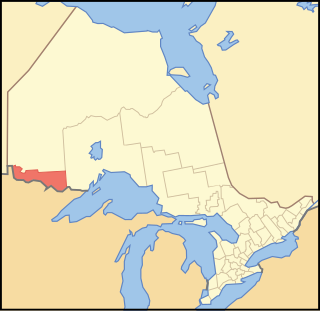
Lake of the Woods County is a county in the U.S. state of Minnesota. As of the 2010 census, the population was 4,045, making it the second-least populous county in Minnesota. Its county seat is Baudette. The county was organized on November 28, 1922, though county functions did not begin until 1923.

Baudette, Minnesota City in Minnesota, United States

Baudette is a city and county seat of Lake of the Woods County, Minnesota, United States. The population was 1,106 at the 2010 census. It is known as the Walleye Capital of the World.

Rainy River, Ontario Town in Ontario, Canada

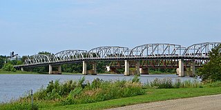
Rainy River is a town in north-western Ontario, Canada, southeast of Lake of the Woods. Rainy River is situated on the eponymous Rainy River, which forms part of the Ontario-Minnesota segment of the Canada–US border. Opposite Rainy River across the river is the town of Baudette, Minnesota. The two towns are connected by the Baudette – Rainy River International Bridge. Rainy River is at the northwestern terminus of Ontario Highway 11.

See also

Coordinates: 48°43′00″N94°35′33″W / 48.7166404°N 94.5924293°W / 48.7166404; -94.5924293 [1]

Geographic coordinate system Coordinate system

A geographic coordinate system is a coordinate system that enables every location on Earth to be specified by a set of numbers, letters or symbols. The coordinates are often chosen such that one of the numbers represents a vertical position and two or three of the numbers represent a horizontal position; alternatively, a geographic position may be expressed in a combined three-dimensional Cartesian vector. A common choice of coordinates is latitude, longitude and elevation. To specify a location on a plane requires a map projection.

Related Research Articles

Koochiching County, Minnesota County in the United States

Koochiching County is a county located in the U.S. state of Minnesota. As of the 2010 census, the population was 13,311. Its county seat is International Falls. A portion of the Bois Forte Indian Reservation is in the county. A small part of Voyageurs National Park extends into its boundary, with Lake of the Woods County to its northwest.

Pigeon River (Minnesota–Ontario) river

The Pigeon River forms part of the Canada–United States border between the state of Minnesota and the province of Ontario, west of Lake Superior. In pre-industrial times the river was a waterway of great importance for transportation and the fur trade.

Rainy River District District in Ontario, Canada

Rainy River District is a district and census division in Northwestern Ontario in the Canadian province of Ontario. It was created in 1885. It is the only division in Ontario that lies completely in the Central Time Zone, except of the township of Atikokan observing Eastern Standard Time year-round. Its seat is Fort Frances. It is known for its fishing and its location on the US border opposite International Falls, Minnesota and Baudette, Minnesota.

Rainy River (Minnesota–Ontario) river on the United States-Canada border

The Rainy River is a river, approximately 137 kilometres (85 mi) long, which forms part of the Canada–United States border separating northern Minnesota and Northwestern Ontario.

MOM's Way is the name for a series of highways in the Canadian provinces of Ontario and Manitoba, and the U.S. state of Minnesota. The name "MOM" is an acronym for Manitoba, Ontario, and Minnesota, the two provinces and one state traversed by this multi-highway route. MOM's Way provides a secondary route between the cities of Winnipeg, Manitoba and Thunder Bay, Ontario.

Minnesota State Highway 11 is a highway in northwest and north-central Minnesota, which runs from North Dakota Highway 66 at the North Dakota state line and continues east to its eastern terminus at the community of Island View at Rainy Lake, near International Falls.

Minnesota State Highway 72 (MN 72) is a highway in northwest Minnesota, which runs from its intersection with U.S. 71 in Blackduck and continues north to its northern terminus at the Canada–US border in Baudette. The road continues as Ontario Highway 11 upon entering the town of Rainy River, Ontario at the Baudette-Rainy River International Bridge.

Minnesota State Highway 172 (MN 172) is a highway in far northern Minnesota, which runs from its intersection with State Highway 11 at Baudette and continues north to its northern terminus in Wheeler's Point at the Lake of the Woods.

Lake of the Woods School is a public high school located in Baudette, Minnesota.

Baudette–Rainy River International Bridge

The Baudette – Rainy River International Bridge is an international bridge connecting Rainy River, Ontario, Canada, with Baudette, Minnesota, United States, across the Rainy River.

Pitt is a ghost town in Lake of the Woods County, Minnesota, United States.

Wheelers Point, Minnesota Unincorporated community in Minnesota, United States

Wheeler's Point is an unincorporated community in Wheeler Township, Lake of the Woods County, Minnesota, United States. It is 12 miles north of Baudette.

Baudette International Airport

Baudette International Airport is a county-owned public-use airport located one mile (2 km) north of the central business district of Baudette, a city in Lake of the Woods County, Minnesota, United States. Also known as Baudette International Airport & Seaplane Base, it is located on the Rainy River, which is the border between Minnesota in the U.S. and Ontario in Canada.

The Baudette fire, also known as the Spooner–Baudette fire, was a large wildfire that burned 1,200 to 1,450 square kilometres in Lake of the Woods County, Minnesota, including nearly all of the twin towns of Spooner and Baudette on October 7, 1910. In addition to Baudette, the fire also burned the villages of Graceton, Pitt, Williams, and Cedar Spur. Damage was horrific yet less so in the communities of Zipple, Roosevelt, Swift and Warroad in the U.S. and Stratton, Pinewood, Rainy River, and Sprague across the river in Canada which also suffered losses. The Town of Rainy River lost its lumber mill, but saved many of the residents of Baudette and Spooner since the residential area was not affected. Their American friends were welcomed into homes where they remained for a very long time as their homes had to be rebuilt, creating a strong bond between the two communities.

Hackett, Minnesota Unincorporated community in Minnesota, United States

Hackett is a small unincorporated community in Wheeler Township, Lake of the Woods County, Minnesota, United States. It lies 10 miles north of Baudette.

Central, Minnesota Unincorporated community in Minnesota, United States

Central is an unincorporated community in Koochiching County, Minnesota, United States; located in the northwest corner of the county; along the Rainy River.

References

International Standard Book Number Unique numeric book identifier

The International Standard Book Number (ISBN) is a numeric commercial book identifier which is intended to be unique. Publishers purchase ISBNs from an affiliate of the International ISBN Agency.