Baynham Hall

Last updated

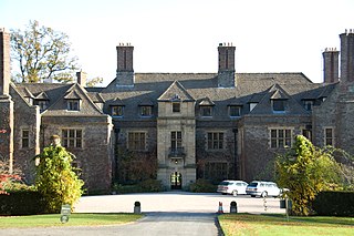
Baynham Hall is a Grade II* listed 17th century manor house located in Michaelchurch-On-Arrow, Gladestry, Powys, Wales.

Listed building Collection of protected architectural creations in the United Kingdom

A listed building, or listed structure, is one that has been placed on one of the four statutory lists maintained by Historic England in England, Historic Environment Scotland in Scotland, Cadw in Wales, and the Northern Ireland Environment Agency in Northern Ireland.

Manor house country house that historically formed the administrative centre of a manor

A manor house was historically the main residence of the lord of the manor. The house formed the administrative centre of a manor in the European feudal system; within its great hall were held the lord's manorial courts, communal meals with manorial tenants and great banquets. The term is today loosely applied to various country houses, frequently dating from the late medieval era, which formerly housed the gentry.

Gladestry village in the county of Powys, Wales

Gladestry is a small village and community in Radnorshire, Powys, mid Wales, close to the border with England at the end of the Hergest Ridge and south of the large moorland area of Radnor Forest.

Originally built circa 1700, the stone house was added to an earlier wing of the previous property and developments. Of William and Mary-aged proportions across five bays, it has a tall hipped roof, pediment gable containing a Venetian window, and tall chimney stacks. Internally the house contains a period staircase with contemporary turned ballastrades. Adjacent to the main house is an L-shaped 18th century corn barn with byres. [1]

William and Mary style

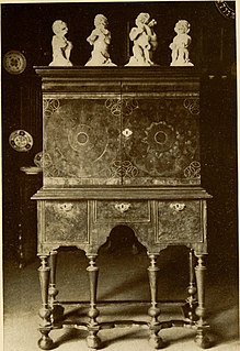
What later came to be known as the William and Mary style is a furniture design common from 1700 to 1725 in the Netherlands, the Kingdom of England, the Kingdom of Scotland, and later, in England's American colonies. It was a transitional style between Mannerist furniture and Queen Anne furniture. Sturdy, emphasizing both straight lines and curves, and featuring elaborate carving and woodturning, the style was one of the first to imitate Asian design elements such as japanning.

Pediment element in classical, neoclassical and baroque architecture

A pediment is an architectural element found particularly in classical, neoclassical and baroque architecture, and its derivatives, consisting of a gable, usually of a triangular shape, placed above the horizontal structure of the entablature, typically supported by columns. The tympanum, the triangular area within the pediment, is often decorated with relief sculpture.

Gable Generally triangular portion of a wall between the edges of intersecting roof pitches

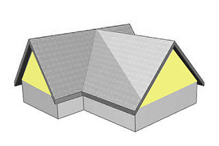
A gable is the generally triangular portion of a wall between the edges of intersecting roof pitches. The shape of the gable and how it is detailed depends on the structural system used, which reflects climate, material availability, and aesthetic concerns. A gable wall or gable end more commonly refers to the entire wall, including the gable and the wall below it.

In 1830, Hugh Lloyd, originally of Llanddewi Ystradenny, Radnorshire, purchased Baynham Hall from William Trumper. [2]

Llanddewi Ystradenni is a community in Radnorshire, Powys, Wales. The population of the Community at the 2011 census was 310.

Radnorshire Historic county of Wales

Radnor or Radnorshire is a sparsely populated area, one of thirteen historic and former administrative counties of Wales. It is represented by the Radnorshire area of Powys, which according to the 2011 census, had a population of 25,821. The historic county was bounded to the north by Montgomeryshire and Shropshire, to the east by Herefordshire, to the south by Brecknockshire and to the west by Cardiganshire.

It was Grade II* listed on the 21 September 1962, [3] and forms part of the Cadw registry of ancient Welsh buildings. [4]

Cadw is the historic environment service of the Welsh Government and part of the Tourism and Culture group. Cadw works to protect the historic buildings and structures, the landscapes and heritage sites of Wales, so that the public can visit them, enjoy them and understand their significance. Cadw manages 127 state owned properties and sites. It arranges events at its managed properties, provides lectures and teaching sessions, offers heritage walks and hosts an online shop. Members of the public can become members of Cadw to gain membership privileges.

Related Research Articles

Llansantffraed village in the county of Powys, Wales

Llansantffraed (Llansantffraed-juxta-Usk) is a parish in the community of Talybont-on-Usk in Powys, Wales near Brecon. The benefice of Llansantffraed with Llanrhystud and Llanddeiniol falls within the diocese of St David's in the Church in Wales.

Llanidloes town in Powys, Wales

Llanidloes is a town and community on the A470 and B4518 roads in Powys, within the historic county boundaries of Montgomeryshire, Wales. The population in 2011 was 2,929, of whom 15% could speak Welsh.

Montgomery, Powys town in the Welsh county of Powys

Montgomery is a town and community in the Welsh Marches, administratively in the Welsh county of Powys. It is the traditional county town of the historic county of Montgomeryshire to which it gives its name. The town centre lies about 1 mile (1.6 km) west of the English border. Montgomery Castle was started in 1223 and its parish church in 1227. Other locations in the town include The Old Bell Museum, the Offa's Dyke Path, the Robber's Grave and the town wall. The large Iron Age hill fort of Ffridd Faldwyn is sited northwest of the town and west of the Castle.

Berriew village in the county of Powys, Wales

Berriew is a village, community and electoral ward in Montgomeryshire, Powys, Wales, on the Montgomeryshire Canal and the Afon Rhiw near the confluence with the River Severn at grid reference SJ185005, 79 miles (128 km) from Cardiff and 151 miles (243 km) from London.

Three Cocks village in United Kingdom

Three Cocks or Aberllynfi is a village near Glasbury in Powys, Wales. The Welsh name refers to the mouth of the Afon Llynfi which enters the River Wye a mile from the village. The nearest town is Hay-on-Wye some 5 miles (8.5 km) to the North East.

Pontrobert hamlet in the county of Powys, Wales

Pontrobert is an ecclesiastical parish that was formed in September 1854. It comprises the townships of Teirtref and part of Nantymerchiard in the parish Meifod, a portion of Cynhinfa which was in the parish of Llangynyw and portions of the townships of Fachwel, Llaethbwlch and Cadwnfa which were in the parish of Llanfihangel. The total area of this parish is 5,000 acres. As a result of this arrangement, Pont Robert is now divided between the present day Community Councils of Meifod, Llangyniew and Mawddwy. Pontrobert was within the historic county of Montgomeryshire, now forming part of Powys. The name Pontrobert is derived from Robert ap Oliver of Cyhinfa, who built the original bridge over the River Vyrnwy around 1700. An alternative Welsh name for Pontrobert is Pont y ddolfeiniog.

Llangoed Hall country house hotel, near the village of Llyswen, in Powys, Mid Wales

Llangoed Hall is a country house hotel, near the village of Llyswen, in Powys, Mid Wales. It is known for its decoration in Laura Ashley fabrics and styles, and was owned by Sir Bernard Ashley, the widower of the designer. It is a Grade II* listed building.

Llanfyllin market town in Powys, Wales

Llanfyllin is a small market town, community and electoral ward in a sparsely-populated area in Montgomeryshire, Powys, Wales. Llanfyllin's population in 2011 was 1,532, of whom 34.1% could speak Welsh. Llanfyllin means church or parish (llan) of St Myllin.

Plas Machynlleth Grade II* listed building in Powys.

Plas Machynlleth was the Welsh residence of the Marquesses of Londonderry. It is situated in the market town of Machynlleth in Powys, Wales. It was brought into the family by the marriage of George Henry Robert Charles William Vane-Tempest, Viscount Seaham, to Mary Cornelia Edwards, whose father Sir John Edwards had extended and renamed the house. It is a Grade II* listed building.

Cwmhir Abbey Grade II* listed building in Abbeycwmhir. Abbey

Cwmhir Abbey, near Llandrindod Wells in Powys, is a Welsh Cistercian monastery founded in 1176 by Cadwallon ap Madog. A spurious tale was later recorded that the abbey was founded in 1143 by Meredudd ap Maelgwn at Ty-faenor, and then refounded at the present location near the village of Abbeycwmhir in 1176. There does appear to be a site movement from Ty-faenor, but Maredudd ap Maelgwn was prince of Maelienydd in 1215 under Prince Llywelyn ab Iorwerth of Gwynedd, who then controlled the district. The later charter to the abbey in 1215 caused the confusion and led to the belief that Maredudd had founded the abbey in 1143.

Glasbury village in the county of Powys, Wales

Glasbury, also known as Glasbury-on-Wye, is a village and community in Powys, Wales. The village lies at an important crossing point on the River Wye, connecting the historic counties of Brecknockshire and Radnorshire, and is located just outside the Brecon Beacons National Park, north of the Black Mountains. The village is split between the communities of Glasbury and Gwernyfed. The nearest town is Hay-on-Wye, some 4 miles (6 km) to the north east. The nearest city is Hereford in England, some 25 miles (40 km) to the east. Glasbury is a popular location for river fishing, canoeing and kayaking. The population of Glasbury community in Radnorshire was 994, in 1841 it was 838.

Llanfechain village in the county of Powys, Wales

Llanfechain is a small village and community in Powys, Wales, between Llanfyllin and Llansantffraid-ym-Mechain on the B4393 road. Historically it was part of Montgomeryshire. Afon Cain runs through the village. It has a population of less than 500.

Brogyntyn country house in Shropshire, England

Brogyntyn, or Porkington, is a mansion in the parish of Selatyn to the north-west of Oswestry in Shropshire, England. Brogyntyn Hall was the home of the Ormsby-Gore family from 1815, and had previously been the estate of their ancestors the Maurices and Owens since the sixteenth century. It was abandoned and uninhabited from around 1985.

Lilford Hall Grade I listed stately home in East Northamptonshire, United Kingdom

Lilford Hall is a Grade I listed stately home in Northamptonshire in the United Kingdom. It was started in 1495 as a Tudor building, with a major Jacobean exterior extension added in 1635 and a Georgian interior adopted in the 1740s, having a 55,000 sq ft (5,100 m2) floor area. The 100-room house is located in the eastern part of the County of Northamptonshire, south of Oundle and north of Thrapston. A Grade I listed building is considered by the UK government as of outstanding architectural and historic interest.

St Michaels Church, Michaelchurch Church in Herefordshire, England

St Michael's Church is a redundant Anglican church in Michaelchurch, Herefordshire, England. It is recorded in the National Heritage List for England as a designated Grade II listed building, and is under the care of the Churches Conservation Trust. It is located in an isolated position in a field some 5 miles (8 km) to the west of Ross-on-Wye. The church is notable for its 13th-century wall paintings, and the presence of a reconstructed Roman altar.

Llanbadarn Fawr, Powys village in Powys, Wales

Llanbadarn Fawr is a community in Powys, within the historic boundaries of Radnorshire, mid Wales. Consisting of a tract of undulating land directly north east of Llandrindod Wells, the community consists of the settlements of Crossgates and Fron and in 2001 had a population of 654, increasing to 701 at the 2011 Census. The community name comes from the local church.

Monk Street, Monmouth

Monk Street is an historic street in the town of Monmouth, Monmouthshire, Wales. A portion of it was in existence by the 14th century, and appears on the 1610 map of the town by cartographer John Speed. It runs in a north-south direction, extending northward from its intersection with Whitecross Street. The name of the street relates to the nearby Priory, as well as the gate which was originally on this road and provided part of the town's defences, Monk's Gate. Monk Street is lined with numerous listed buildings.

Abercynllaith hamlet in Powys, Wales

Abercynllaith, also sometimes referred to as Aberkenllith, is a hamlet, between Llangedwyn and Pen-y-bont in northeastern Powys, Wales. It lies to the southwest of Oswestry, Shropshire, along the B4396 road, near the English border.

Mount Stuart Square

Mount Stuart Square is a residential and commercial square in Cardiff, Wales. It is located in the Butetown area of the city. Originally developed in the late 1800s as a residential location for nearby dock workers, it quickly became a centre for upscale residential properties which revolved around the main square. By 1900, commercial activity had taken its place, dominated by the Coal Exchange, which occupied the once open central space. The square contains a high concentration of listed buildings, which represent a range of architectural styles and some of Cardiff's finest examples of late 19th and early 20th Century commercial architecture. Mount Stuart Square area was designated a Conservation Area in July 1980.

References

  1. Richard Haslam (1 January 1979). Powys - Pevsner Architectural Guides: Buildings of Wales. Yale University Press. ISBN   0300096313.
  2. "Baynham Hall". LloydsofBaynham.com. Retrieved 16 February 2013.
  3. "Baynham Hall, Michaelchurch-On-Arrow, Gladestry". britishlistedbuildings.co.uk. Retrieved 16 February 2013.
  4. "Baynham Hall". coflein.gov.uk. Archived from the original on 23 April 2013. Retrieved 16 February 2013.

Coordinates: 52°09′15″N3°07′22″W / 52.1542°N 3.1227°W / 52.1542; -3.1227

Geographic coordinate system Coordinate system

A geographic coordinate system is a coordinate system that enables every location on Earth to be specified by a set of numbers, letters or symbols. The coordinates are often chosen such that one of the numbers represents a vertical position and two or three of the numbers represent a horizontal position; alternatively, a geographic position may be expressed in a combined three-dimensional Cartesian vector. A common choice of coordinates is latitude, longitude and elevation. To specify a location on a plane requires a map projection.