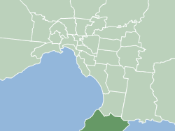
The Shire of Mornington Peninsula is a local government area in southeastern Metropolitan Melbourne, Victoria, Australia. It is located to the south of the Melbourne City Centre. It has an area of 724 square kilometres and in June 2018 it had a population of 165,822.
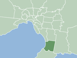
The City of Frankston is a local government area (LGA) in Victoria, Australia in the southern suburbs of Melbourne. It has an area of 130 square kilometres, and in June 2018, the City of Frankston recorded a population of 141,845.

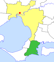
The Mornington Peninsula is a peninsula located south of Melbourne, Victoria, Australia. It is surrounded by Port Phillip to the west, Western Port to the east and Bass Strait to the south, and is connected to the mainland in the north. Geographically, the peninsula begins its protrusion from the mainland in the area between Pearcedale and an area north of Frankston. The area was originally home to the Mayone-bulluk and Boonwurrung-Balluk clans and formed part of the Boonwurrung nation's territory prior to European settlement.
Hampton Park is a suburb in Melbourne, Victoria, Australia, 36 km south-east of Melbourne's Central Business District, located within the City of Casey local government area. Hampton Park recorded a population of 26,082 at the 2021 census.

Pearcedale is a township and coastal rural locality in Victoria, Australia, 49 km south-east of Melbourne's Central Business District, located within the City of Casey and the Shire of Mornington Peninsula local government areas. Pearcedale recorded a population of 3,867 at the 2021 census.

Carrum Downs is a suburb in Melbourne, Victoria, Australia, 36 km south-east of Melbourne's Central Business District, located within the City of Frankston local government area. Carrum Downs recorded a population of 21,976 at the 2021 census.

Frankston is a suburb in Melbourne, Victoria, Australia, 41 km (25 mi) south-east of Melbourne's Central Business District, located within the City of Frankston local government area. Frankston recorded a population of 37,331 at the 2021 census.

Mount Eliza is a seaside suburb on the Mornington Peninsula in Melbourne, Victoria, Australia, 42 km (26 mi) south-east of Melbourne's Central Business District, located within the Shire of Mornington Peninsula local government area. Mount Eliza recorded a population of 18,734 at the 2021 census.

Somerville is a suburb on the Mornington Peninsula in Melbourne, Victoria, Australia, 49 km (30 mi) south-east of Melbourne's Central Business District, located within the Shire of Mornington Peninsula local government area. Somerville recorded a population of 11,767 at the 2021 census.

Carrum is a suburb in Melbourne, Victoria, Australia, 33 km (21 mi) south-east of Melbourne's Central Business District, located within the City of Kingston local government area. Carrum recorded a population of 4,239 at the 2021 census.

The Mornington Peninsula Freeway is a freeway in Melbourne, Victoria, Australia, that provides a link from south-eastern suburban Melbourne to the Mornington Peninsula. Whilst the entire freeway from Dingley Village to Rosebud is declared by VicRoads as the Mornington Peninsula Freeway, the section between EastLink in Carrum Downs and Moorooduc Highway in Moorooduc is locally and commonly known as Peninsula Link. The entire freeway corridor bears the designation M11.

Peninsula Grammar, formerly The Peninsula School, is an Australian independent, co-educational, Anglican, day and boarding school located in Mount Eliza, Victoria.
Brighton East is a suburb in Melbourne, Victoria, Australia, 12 km south-east of Melbourne's Central Business District, located within the Cities of Bayside and Glen Eira local government areas. Brighton East recorded a population of 16,757 at the 2021 census.

Frankston High School or simply Frankston High, is a government-funded co-educational high school, located in Frankston, Melbourne, Victoria, Australia. The school offers education for students from Year 7 to Year 12.
The Peninsula campus of Monash University is Monash's third-largest campus, with close to 4000 students and almost 300 staff. The campus is located at the "Gateway to the Mornington Peninsula", in the Bayside suburb of Frankston. It continues to specialise in its historical strengths of health and early childhood education. Monash teaching in primary education, nursing and physiotherapy are all based at Peninsula Campus. The campus offers programs from undergraduate through to PhD level. It has research strengths in health and well-being, education and business. At any one time, there are around 100 higher degree by research students at Peninsula Campus.
The Shire of Hastings was a local government area about 60 kilometres (37 mi) south-southeast of Melbourne, the state capital of Victoria, Australia, encompassing the eastern extremity of the Mornington Peninsula. The shire covered an area of 304.6 square kilometres (117.6 sq mi), and existed from 1960 until 1994.

The Shire of Mornington was a local government area about 50 kilometres (31 mi) south of Melbourne, the state capital of Victoria, Australia, encompassing the western extremity of the Mornington Peninsula. The shire covered an area of 90.65 square kilometres (35.0 sq mi) immediately to the south of Frankston, and existed from 1860 until 1994.
Karingal is a local area within the suburb of Frankston located in Melbourne, Victoria in Australia. It is in the local government area of the City of Frankston
Padua College is a Catholic co-educational Secondary College located in Victoria, Australia. The college derives its name from Franciscan friar Saint Anthony of Padua (1195–1231). The Mornington campus alone provides for approximately 2,404 students from across the Mornington Peninsula. The college also has two smaller campuses that cater for students in years 7-9 in Rosebud and in Tyabb.
Bayside Church is an Australia church in fellowship with Crosslink Christian Network. The church is based in the Melbourne Bayside suburbs of Cheltenham and Frankston. The church’s founding senior pastors are Rob and Christie Buckingham.
